干旱区地理 ›› 2024, Vol. 47 ›› Issue (4): 599-611.doi: 10.12118/j.issn.1000-6060.2023.222 cstr: 32274.14.ALG2023222
董晓媛( ), 胥德泽, 施小斌, 杜森()
收稿日期:2023-05-15
修回日期:2023-06-29
出版日期:2024-04-25
发布日期:2024-05-17
通讯作者:
杜森(1980-),男,副教授,主要从事城乡规划与设计、国土空间规划等方面的研究. E-mail: dusen@mail.lzjtu.cn作者简介:董晓媛(1980-),女,讲师,主要从事城市地理信息系统、国土空间规划等方面的研究. E-mail: dongxiaoyuan@mail.lzjtu.cn
基金资助:
DONG Xiaoyuan(), XU Deze, SHI Xiaobin, DU Sen()
Received:2023-05-15
Revised:2023-06-29
Published:2024-04-25
Online:2024-05-17
摘要:
为探究适用于黄河流域甘肃段生态环境的保护理论与方法,解决该区域生态环境保护与社会经济发展的矛盾问题,选取适合黄河流域甘肃段生态敏感性评价因子,利用层次分析法和GIS空间分析方法,定量评价广河县生态敏感性,并选取GDP、人均GDP、人口密度等6项社会经济指标,结合耦合度模型和耦合协调度模型,分别探究生态敏感性与其的耦合协调关系。研究表明:(1) 水体、土壤可蚀性、植被覆盖与土地利用类型对广河县生态敏感性影响较强烈。(2) 生态敏感性子系统与各社会经济指标子系统呈现出较强的空间相关性,互相依存关系明显,耦合度水平均处于较高状态。(3) 耦合协调度研究中生态敏感性子系统与人均GDP、矿产资源指标子系统处于协调发展状态,生态敏感性子系统与GDP、人口密度、工业指标与养殖业指标子系统处于拮抗发展状态。研究生态敏感性与社会经济发展的相关性,为该区域提供差异化的发展与保护协调路径,并为同类型区域提供借鉴。
董晓媛, 胥德泽, 施小斌, 杜森. 黄河流域甘肃段生态敏感性评价研究——以广河县为例[J]. 干旱区地理, 2024, 47(4): 599-611.
DONG Xiaoyuan, XU Deze, SHI Xiaobin, DU Sen. Ecological sensitivity evaluation of the Gansu section of the Yellow River: A case study of Guanghe County[J]. Arid Land Geography, 2024, 47(4): 599-611.
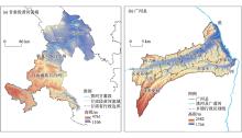
图1
研究示意图"
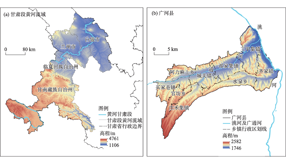
表1
广河县生态敏感性评价指标体系"
| 评价指标 | 低敏感 | 较低敏感 | 一般敏感 | 较高敏感 | 高敏感 | |
|---|---|---|---|---|---|---|
| 地形条件 | 海拔/m | <1914 | 1914~2047 | 2047~2165 | 2165~2311 | >2311 |
| 坡度/(°) | <7.8 | 7.8~15.5 | 15.5~23.2 | 23.2~33.3 | >33.3 | |
| 坡向 | 平地、正南 | 东南、西南 | 正东、正西 | 东北、西北 | 正北 | |
| 自然环境 | 水体/m | <50 | 50~200 | 200~500 | 500~1000 | >1000 |
| 植被覆盖 | >0.49 | 0.42~0.49 | 0.34~0.42 | 0.26~0.34 | <0.26 | |
| 土壤可蚀性 | <0.039 | 0.039~0.041 | 0.041~0.043 | 0.043~0.045 | >0.045 | |
| 降雨侵蚀力 | <1344 | 1344~1447 | 1447~1546 | 1546~1690 | >1690 | |
| 人类活动 | 土地利用类型 | 水域 | 林地 | 草地 | 耕地 | 建设用地、未利用土地 |
表2
指标因子对比矩阵及权重"
| 指标 | 海拔 | 坡度 | 坡向 | 水体 | 植被覆盖 | 土壤可蚀性 | 降雨侵蚀力 | 土地利用类型 | 权重 | 权重排序 |
|---|---|---|---|---|---|---|---|---|---|---|
| 海拔 | 1 | 3 | 5 | 1/3 | 1/4 | 1/3 | 1/3 | 1/5 | 0.066 | 6 |
| 坡度 | 1/3 | 1 | 3 | 1/5 | 1/5 | 1/3 | 1/3 | 1/5 | 0.042 | 7 |
| 坡向 | 1/5 | 1/3 | 1 | 1/5 | 1/7 | 1/5 | 1/5 | 1/9 | 0.024 | 8 |
| 水体 | 3 | 5 | 5 | 1 | 1/2 | 1 | 1 | 1/3 | 0.132 | 5 |
| 植被覆盖 | 4 | 5 | 7 | 2 | 1 | 1 | 3 | 1 | 0.218 | 2 |
| 土壤可蚀性 | 3 | 3 | 5 | 1 | 1 | 1 | 1 | 1 | 0.156 | 3 |
| 降雨侵蚀力 | 3 | 3 | 5 | 1 | 1/3 | 1 | 1 | 1/3 | 0.117 | 4 |
| 土地利用类型 | 5 | 5 | 9 | 3 | 1 | 1 | 3 | 1 | 0.245 | 1 |
表3
单因子生态敏感性评价数据"
| 指标 | 低敏感 | 较低敏感 | 一般敏感 | 较高敏感 | 高敏感 | |||||||||
|---|---|---|---|---|---|---|---|---|---|---|---|---|---|---|
| 面积/km2 | 占比/% | 面积/km2 | 占比/% | 面积/km2 | 占比/% | 面积/km2 | 占比/% | 面积/km2 | 占比/% | |||||
| 海拔 | 83.71 | 15.55 | 133.90 | 24.87 | 158.07 | 29.36 | 122.91 | 22.83 | 39.75 | 7.38 | ||||
| 坡度 | 136.21 | 25.30 | 151.43 | 28.13 | 143.40 | 26.64 | 79.14 | 14.70 | 26.24 | 4.87 | ||||
| 坡向 | 49.73 | 9.27 | 104.37 | 19.46 | 159.70 | 29.77 | 153.21 | 28.56 | 69.40 | 12.94 | ||||
| 水体 | 33.73 | 6.29 | 49.04 | 9.14 | 111.16 | 20.72 | 142.88 | 26.64 | 201.52 | 37.57 | ||||
| 植被覆盖 | 4.43 | 0.83 | 65.68 | 12.25 | 202.61 | 37.77 | 238.62 | 44.48 | 27.00 | 5.03 | ||||
| 土壤可蚀性 | 0.05 | 0.01 | 124.88 | 23.28 | 139.62 | 26.03 | 157.06 | 29.28 | 116.72 | 21.76 | ||||
| 降雨侵蚀力 | 66.17 | 12.34 | 131.69 | 24.55 | 140.04 | 26.11 | 105.27 | 19.62 | 95.17 | 17.74 | ||||
| 土地利用类型 | 11.75 | 2.19 | 11.46 | 2.14 | 322.75 | 60.17 | 166.72 | 31.08 | 25.66 | 4.78 | ||||
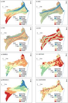
图2
各评价因子敏感性集合"

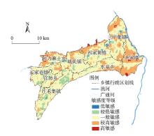
图3
综合生态敏感性分析"
表4
综合生态敏感性分析"
| 指标 | 低敏感 | 较低敏感 | 一般敏感 | 较高敏感 | 高敏感 | |||||||||
|---|---|---|---|---|---|---|---|---|---|---|---|---|---|---|
| 面积/km2 | 占比/% | 面积/km2 | 占比/% | 面积/km2 | 占比/% | 面积/km2 | 占比/% | 面积/km2 | 占比/% | |||||
| 综合生态 敏感性指数 | 6.41 | 1.19 | 55.14 | 10.28 | 308.50 | 57.51 | 159.01 | 29.64 | 7.34 | 1.37 | ||||
图4
生态敏感性与社会经济指标耦合度"
表5
广河县生态敏感性与社会经济指标耦合协调类型及发展状态"
| 耦合协调度分级 | 类型 | 耦合协调发展状态 | 耦合协调度分级 | 类型 | 耦合协调发展状态 |
|---|---|---|---|---|---|
| 0.0≤D<0.5 | 失调 | 严重拮抗 | 0.7≤D<0.85 | 中度耦合协调 | 磨合 |
| 0.5≤D<0.7 | 低耦合协调 | 拮抗 | 0.85≤D≤1.0 | 高度耦合协调 | 协调 |
图5
生态敏感性与社会经济指标耦合协调度"
| [1] |
陆大道, 孙东琪. 黄河流域的综合治理与可持续发展[J]. 地理学报, 2019, 74(12): 2431-2436.
doi: 10.11821/dlxb201912001 |
|
[Lu Dadao, Sun Dongqi. Development and management tasks of the Yellow River Basin: A preliminary understanding and suggestion[J]. Acta Geographica Sinica, 2019, 74(12): 2431-2436. ]
doi: 10.11821/dlxb201912001 |
|
| [2] | 赵诚诚, 潘竟虎. 基于供需视角的黄河流域甘肃段生态安全格局识别与优化[J]. 生态学报, 2022, 42(17): 6973-6984. |
| [Zhao Chengcheng, Pan Jinghu. Ecological safety pattern identification and optimization based on the ecologicalsupply and demand in Gansu section of the Yellow River Basin[J]. Acta Ecologica Sinica, 2022, 42(17): 6973-6984. ] | |
| [3] | 李元征, 冯智志, 李立, 等. 基于GIS的黄河流域陆地生态系统生态敏感性评价[J]. 环境科学与技术, 2021, 44(4): 219-225. |
| [Li Yuanzheng, Feng Zhizhi, Li Li, et al. Assessment of ecological sensitivity of terrestrial ecosystem in the Yellow River Basin based on GIS[J]. Environmental Science & Technology, 2021, 44(4): 219-225. ] | |
| [4] | Seidl R, Aggestam F, Rammer W, et al. The sensitivity of current and future forest managers to climate-induced changes in ecological processes[J]. Ambio, 2015, 45: 430-441. |
| [5] | Raupach M, Haverd V, Briggs P. Sensitivities of the Australian terrestrial water and carbon balances to climate change and variability[J]. Agricultural and Forest Meteorology, 2013, 182-183: 277-291. |
| [6] | Jin X, Wei L, Wang Y, et al. Construction of ecological security pattern based on the importance of ecosystem service functions and ecological sensitivity assessment: A case study in Fengxian County of Jiangsu Province, China[J]. Environment Development and Sustainability, 2020, 23: 563-590. |
| [7] | Chen J, Wang S, Zou Y. Construction of an ecological security pattern based on ecosystem sensitivity and the importance of ecological services: A case study of the Guanzhong Plain urban agglomeration, China[J]. Ecological Indicators, 2022, 136: 108688, doi: 10.1016/j.ecolind.2022.108688. |
| [8] | Hu X, Ma C, Huang P, et al. Ecological vulnerability assessment based on AHP-PSR method and analysis of its single parameter sensitivity and spatial autocorrelation for ecological protection? A case of Weifang City, China[J]. Ecological Indicators, 2021, 125: 107464, doi: 10.1016/j.ecolind.2021.107464. |
| [9] | Su X, Zhou Y, Li Q. Designing ecological security patterns based on the framework of ecological quality and ecological sensitivity: A case study of Jianghan Plain, China[J]. International Journal of Environmental Research and Public Health, 2021, 18(8383): 1-31. |
| [10] | Zhang Q, Wang G, Yuan R, et al. Dynamic responses of ecological vulnerability to land cover shifts over the Yellow River Basin, China[J]. Ecological Indicators, 2022, 144: 109554, doi: 10.1016/j.ecolind.2022.109554. |
| [11] | Li T, Zhang Q, Singh V P, et al. Identification of degradation areas of ecological environment and degradation intensity assessment in the Yellow River Basin[J]. Frontiers in Earth Science, 2022, 10: 1-14. |
| [12] | 张恩伟, 彭双云, 冯华梅. 基于GIS和RUSLE的滇池流域土壤侵蚀敏感性评价及其空间格局演变[J]. 水土保持学报, 2020, 34(2): 115-122. |
| [Zhang Enwei, Peng Shuangyun, Feng Huamei. Sensitivity assessment of soil erosion and its spatial pattern evolution in Dianchi Lake Basin based on GIS and RUSLE[J]. Journal of Soil and Water Conservation, 2020, 34(2): 115-122. ] | |
| [13] | 杨志峰, 徐俏, 何孟常, 等. 城市生态敏感性分析[J]. 中国环境科学, 2002(4): 73-77. |
| [Yang Zhifeng, Xu Qiao, He Mengchang, et al. Analysis of city ecosensitivity[J]. China Environmental Science, 2002(4): 73-77. ] | |
| [14] | 吴金华, 李纪伟, 朱鸿儒. 基于ArcGIS区统计的延安市土地生态敏感性评价[J]. 自然资源学报, 2011, 26(7): 1180-1188. |
| [Wu Jinhua, Li Jiwei, Zhu Hongru. Land ecological sensitivity evaluation of Yan’an based on zonal statistics of ArcGIS[J]. Journal of Natural Resources, 2011, 26(7): 1180-1188. ] | |
| [15] | 刘海龙, 王炜桥, 王跃飞, 等. 汾河流域生态敏感性综合评价及时空演变特征[J]. 生态学报, 2021, 41(10): 3952-3964. |
| [Liu Hailong, Wang Weiqiao, Wang Yuefei, et al. Comprehensive evaluation of ecological sensitivity and the characteristics of spatiotemporal variations in the Fenhe River Basin[J]. Acta Ecologica Sinica, 2021, 41(10): 3952-3964. ] | |
| [16] | 贾良清, 欧阳志云, 赵同谦, 等. 安徽省生态功能区划研究[J]. 生态学报, 2005, 25(2): 254-260. |
| [Jia Liangqing, Ouyang Zhiyun, Zhao Tongqian, et al. The ecological function regionalization of Anhui Province[J]. Acta Ecologica Sinica, 2005, 25(2): 254-260. ] | |
| [17] | 朱金峰, 周艺, 王世新, 等. 白洋淀湿地生态功能评价及分区[J]. 生态学报, 2020, 40(2): 459-472. |
| [Zhu Jinfeng, Zhou Yi, Wang Shixin, et al. Ecological function evaluation and regionalization in Baiyangdian Wetland[J]. Acta Ecologica Sinica, 2020, 40(2): 459-472. ] | |
| [18] | 熊善高, 秦昌波, 于雷, 等. 基于生态系统服务功能和生态敏感性的生态空间划定研究——以南宁市为例[J]. 生态学报, 2018, 38(22): 7899-7911. |
| [Xiong Shangao, Qin Changbo, Yu Lei, et al. Methods to identify the boundary of ecological space based on ecosystem service functions and ecological sensitivity: A case study of Nanning City[J]. Acta Ecologica Sinica, 2018, 38(22): 7899-7911. ] | |
| [19] | 杨姗姗, 邹长新, 沈渭寿, 等. 基于生态红线划分的生态安全格局构建——以江西省为例[J]. 生态学杂志, 2016, 35(1): 250-258. |
| [Yang Shanshan, Zou Changxin, Shen Weishou, et al. Construction of ecological security patterns based on ecological red line: A case study of Jiangxi Province[J]. Chinese Journal of Ecology, 2016, 35(1): 250-258. ] | |
| [20] | 田柳兰, 王珊珊, 毋兆鹏. 基于多时相遥感数据的乌鲁木齐市生态安全格局构建[J]. 干旱区地理, 2023, 46(7): 1155-1165. |
| [Tian Liulan, Wang Shanshan, Wu Zhaopeng. Construction of ecological security pattern in Urumqi based on multi-temporal remote sensing data[J]. Arid Land Geography, 2023, 46(7): 1155-1165. ] | |
| [21] | 刘学, 杨春艳, 高艳妮, 等. 厦门市生态安全格局识别与生态管控区分级管控研究[J/OL]. 生态学报, 2023(13): 1-13. |
| [Liu Xue, Yang Chunyan, Gao Yanni, et al. Identification of ecological security patterns and hierarchical management of ecological control area in Xiamen[J/OL]. Acta Ecologica Sinica, 2023(13): 1-13. ] | |
| [22] | 李伊彤, 荣丽华, 李文龙, 等. 生态重要性视角下东北林区县域生态安全格局研究——以呼伦贝尔市阿荣旗为例[J]. 干旱区地理, 2022, 45(5): 1615-1625. |
| [Li Yitong, Rong Lihua, Li Wenlong, et al. Ecological security pattern at county level in northeast forest area of China from the perspective of ecological importance: A case of Arun Banner in Hulun Buir City[J]. Arid Land Geography, 2022, 45(5): 1615-1625. ] | |
| [23] | 李洪庆, 杨瑀, 张俊红. 雅鲁藏布江山南宽谷流域生态安全格局构建[J]. 干旱区地理, 2023, 46(9): 1503-1513. |
| [Li Hongqing, Yang Yu, Zhang Junhong. Construction of ecological security pattern in Shannan Wide Valley Basin of Yarlung Zangbo River[J]. Arid Land Geography, 2023, 46(9): 1503-1513. ] | |
| [24] | 李益敏, 管成文, 郭丽琴, 等. 基于生态敏感性分析的江川区土地利用空间格局优化配置[J]. 农业工程学报, 2018, 34(20): 267-276. |
| [Li Yimin, Guan Chengwen, Guo Liqin, et al. Optimization of land use spatial pattern in Jiangchuan District based on ecological sensitivity analysis[J]. Transactions of the Chinese Society of Agricultural Engineering, 2018, 34(20): 267-276. ] | |
| [25] | 程逸楠, 苏光, 秦晓春, 等. 基于景观生态学的旅游公路路域景观现状与生态敏感性研究[J]. 中国园林, 2020, 36(1): 113-117. |
| [Cheng Yinan, Su Guang, Qin Xiaochun, et al. study on landscape status and ecological sensitivity of tourism highway roads based on landscape ecology[J]. Chinese Landscape Architecture, 2020, 36(1): 113-117. ] | |
| [26] | 刘军会, 高吉喜, 马苏, 等. 中国生态环境敏感区评价[J]. 自然资源学报, 2015, 30(10): 1607-1616. |
|
[Liu Junhui, Gao Jixi, Ma Su, et al. Evaluation of ecological sensitivity in China[J]. Journal of Natural Resources, 2015, 30(10): 1607-1616. ]
doi: 10.11849/zrzyxb.2015.10.001 |
|
| [27] | 欧阳志云, 王效科, 苗鸿. 中国生态环境敏感性及其区域差异规律研究[J]. 生态学报, 2000, 20(1): 9-12. |
| [Ouyang Zhiyun, Wang Xiaoke, Miao Hong. China’s eco-environmental sensitivity and its spatial heterogeneity[J]. Acta Ecologica Sinica, 2000, 20(1): 9-12. ] | |
| [28] | 苏溥雅, 齐实, 梁斌, 等. 西北五省生态敏感性分析[J]. 甘肃农业大学学报, 2019, 54(2): 171-179. |
| [Su Puya, Qi Shi, Liang Bin, et al. Analysis of ecological sensitivity of five provinces in northwestern China[J]. Journal of Gansu Agricultural University, 2019, 54(2): 171-179. ] | |
| [29] | 王后阵, 蔡广鹏, 郜红娟. 贵州省生态敏感性与社会经济相关性分析[J]. 湖南师范大学自然科学学报, 2017, 40(2): 11-16. |
| [Wang Houjian, Cai Guangpeng, Gao Hongjuan. Analysis of ecological sensitivity and socio-economic correlation in Guizhou Province[J]. Journal of Natural Science of Hunan Normal University, 2017, 40(2): 11-16. ] | |
| [30] | 史娜娜, 全占军, 韩煜, 等. 基于生态敏感性评价的乌海市土地资源承载力分析[J]. 水土保持研究, 2017, 24(1): 239-243. |
| [Shi Nana, Quan Zhanjun, Han Yu, et al. Analysis of land resources carrying capacity in Wuhai City based on ecological sensitivity[J]. Research of Soil and Water Conservation, 2017, 24(1): 239-243. ] | |
| [31] | 张玉, 马良, 庞海威, 等. 基于水力侵蚀影响因子评价济南市南部山区生态敏感性[J]. 济南大学学报(自然科学版), 2023, 37(5): 553-558. |
| [Zhang Yu, Ma Liang, Pang Haiwei, et al. Ecological sensitivity in southern mountain region of Jinan City evaluated on the basis of influencing factors of hydraulic erosion[J]. Journal of University of Jinan (Science and Technology Edition), 2023, 37(5): 553-558. ] | |
| [32] | 奥勇, 蒋嶺峰, 白召弟, 等. 基于格网GIS的黄河流域土地生态质量综合评价[J]. 干旱区地理, 2022, 45(1): 164-175. |
| [Ao Yong, Jiang Lingfeng, Bai Zhaodi, et al. Comprehensive evaluation of land ecological quality in the Yellow River Basin based on Grid-GIS[J]. Arid Land Geography, 2022, 45(1): 164-175. ] | |
| [33] | 亚库普·约麦尔, 阿里木江·卡斯木. 喀什市土地利用变化下的生态敏感性研究[J]. 生态科学, 2016, 35(2): 19-25. |
| [Yuemaier Yakupu, Kasimu Alimujiang. Ecological sensitivity analysis of land use change in Kashgar City[J]. Ecological Science, 2016, 35(2): 19-25. ] | |
| [34] | 蒲欣冬, 刘兰涛, 陈怀录, 等. 甘肃省广河县土地利用分区研究[J]. 干旱区资源与环境, 2013, 27(2): 64-68. |
| [Pu Xindong, Liu Lantao, Chen Huailu, et al. The zoning of land utilization division in Guanghe, Gansu[J]. Journal of Arid Land Resources and Environment, 2013, 27(2): 64-68. ] | |
| [35] | 张科利, 彭文英, 杨红丽. 中国土壤可蚀性值及其估算[J]. 土壤学报, 2007, 44(1): 7-13. |
| [Zhang Keli, Peng Wenying, Yang Hongli. Soil erodibility and itd estimation for agriculrural soil in China[J]. Acta Pedologica Sinica, 2007, 44(1): 7-13. ] | |
| [36] | 王万忠, 焦菊英. 中国的土壤侵蚀因子定量评价研究[J]. 水土保持通报, 1996(5): 1-20. |
| [Wang Wanzhong, Jiao Juying. Qutantitative evaluation on factors influencing soil erosion in China[J]. Bulletin of Soil and Water Conservation, 1996(5): 1-20. ] | |
| [37] | Zhao Naizhou, Liu Ying, Cao Guofeng, et al. Forecasting China’s GDP at the pixel level using nighttime lights time series and population images[J]. Giscience & Remote Sensing, 2017, 54(3): 407-425. |
| [38] | 许振宇, 贺建林. 湖南省生态经济系统耦合状态分析[J]. 资源科学, 2008, 30(2): 185-191. |
| [Xu Zhengyu, He Jianlin. Analysis of coupling status between ecological system and economic system in Hunan Province[J]. Resource Science, 2008, 30(2): 185-191. ] | |
| [39] | 黄金川, 方创琳. 城市化与生态环境交互耦合机制与规律性分析[J]. 地理研究, 2003, 22(2): 211-220. |
|
[Huang Jinchuan, Fang Chuanglin. Analysis of coupling mechanism and rules between urbanization and eco-environment[J]. Geographical Research, 2003, 22(2): 211-220. ]
doi: 10.11821/yj2003020010 |
|
| [40] | 张传华, 张凤太, 王钟书, 等. 生态敏感区村域尺度土地生态经济系统的耦合协调发展研究——以重庆市江津区为例[J]. 长江流域资源与环境, 2021, 30(7): 1547-1558. |
| [Zhang Chuanhua, Zhang Fengtai, Wang Zhongshu, et al. Study on the coupling and coordinated development of land eco-economic system in village scale in the ecologically sensitive area: A case of Jiangjin District,Chongqing, China[J]. Resources and Environment in the Yangtze Basin, 2021, 30(7): 1547-1558. ] | |
| [41] | 吴帛阳, 高英杰, 栾春凤. 基于生态敏感性评价的风景名胜区生态保护对策研究——以尧山风景名胜区为例[J]. 甘肃农业大学学报, 2023, 58(2): 180-188, 199. |
| [Wu Boyang, Gao Yingjie, Luan Chunfeng. Developing ecological protection strategies for scenic spots based on ecological sensitivity[J]. Journal of Gansu Agricultural University, 2023, 58(2): 180-188, 199. ] | |
| [42] | 尹海伟, 徐建刚, 陈昌勇, 等. 基于GIS的吴江东部地区生态敏感性分析[J]. 地理科学, 2006, 26(1): 64-69. |
|
[Yin Haiwei, Xu JianGang, Chen Changyong, et al. GIS-based ecological sensitivity analysis in the east of Wujiang City[J]. Scientia Geographica Sinica, 2006, 26(1): 64-69. ]
doi: 10.13249/j.cnki.sgs.2006.01.64 |
|
| [43] | 李大龙, 杨井, 李卫红, 等. 基于GIS和USLE的伊犁河谷土壤侵蚀敏感性评价[J]. 生态学杂志, 2016, 35(4): 942-951. |
| [Li Dalong, Yang Jing, Li Weihong, et al. Evaluating the sensitivity of soil erosion in the Yili River valley based on GIS and USLE[J]. Chinese Journal of Ecology, 2016, 35(4): 942-951. ] | |
| [44] | 马亚亚, 刘国彬, 张超, 等. 陕北安塞县生态与经济系统耦合协调发展[J]. 生态学报, 2019, 39(18): 6840-6849. |
| [Ma Yaya, Liu Guobin, Zhang Chao, et al. Research on the coordinated development of ecological and economic systems in Ansai County, northern Shaanxi Province[J]. Acta Ecologica Sinica, 2019, 39(18): 6840-6849. ] | |
| [45] | 毕国华, 杨庆媛, 刘苏. 中国省域生态文明建设与城市化的耦合协调发展[J]. 经济地理, 2017, 37(1): 50-58. |
| [Bi Guohua, Yang Qingyuan, Liu Su. Coupling coordination development between ecological civilization constructionand urbanization in China[J]. Economic Geography, 2017, 37(1): 50-58. ] |
| [1] | 李梦园, 庞家朋, 李欢. 省域典型旅游集散地综合可达性协调发展及空间关系研究——以新疆为例[J]. 干旱区地理, 2025, 48(3): 539-548. |
| [2] | 刘苗苗, 吴卫东. 陕西省新型城镇化与乡村振兴耦合性实证研究[J]. 干旱区地理, 2024, 47(8): 1420-1430. |
| [3] | 王超, 雷婷, 孟晓莎, 樊建强. “交旅”融合下旅游经济与高速交通协调发展分析——以关中平原城市群为例[J]. 干旱区地理, 2024, 47(6): 1015-1025. |
| [4] | 卢泉, 高花彦, 王鹏鹏, 冯啸林, 杨艳霞. 塔里木河流域水-耕地-粮棉系统耦合关系及影响因素分析[J]. 干旱区地理, 2024, 47(5): 820-829. |
| [5] | 曹佳琳, 刘艳芳, 赵金梅, 安睿, 胡艺川, 孙文杰, 辛格格. 宁夏城市建设用地节约集约利用与高质量发展耦合协调研究[J]. 干旱区地理, 2024, 47(5): 872-884. |
| [6] | 赵雪纯, 菊春燕. 公园绿地与城市功能空间耦合协调关系及影响因素分析——以乌鲁木齐市为例[J]. 干旱区地理, 2024, 47(5): 898-908. |
| [7] | 闫天亮, 王承武, 陈梦茜, 陈暄, 赵文静. 基于土地生态敏感性评价的生态产品价值分区实现研究——以阿勒泰市为例[J]. 干旱区地理, 2024, 47(4): 612-621. |
| [8] | 刘玒玒, 刘书芳. 祁连山地区复合生态系统韧性时空演化及障碍因子识别[J]. 干旱区地理, 2024, 47(2): 237-247. |
| [9] | 万赟, 吴文恒, 刘金凤, 史海金, 刘力萌. 近30 a黄河流域中心城市空间扩展特征及启示[J]. 干旱区地理, 2024, 47(2): 281-292. |
| [10] | 陈繁繁, 白永平, 梁建设, 张春悦, 赵越, 龚享林. 兰州市蔬菜市场的空间分布特征及影响因素研究[J]. 干旱区地理, 2024, 47(2): 293-306. |
| [11] | 张立新, 张家瑞. 中国新基建与区域韧性耦合协调发展:时空差异与演变趋势[J]. 干旱区地理, 2024, 47(12): 2164-2176. |
| [12] | 李海央, 杨敏. 中国西北农作制区耕地利用“显-隐性”形态耦合协调度研究[J]. 干旱区地理, 2024, 47(11): 1924-1934. |
| [13] | 吉泽男, 付文婷, 王鹏程, 廖升, 潘铮. 干旱区数字经济与农业绿色发展耦合协调研究——以新疆为例[J]. 干旱区地理, 2024, 47(11): 1981-1990. |
| [14] | 孟晓, 田明华, 杜磊, 马爽. 中国农业农村现代化发展水平测度及其协调性研究[J]. 干旱区地理, 2024, 47(1): 137-146. |
| [15] | 王冠孝,王伟,张娟娟. 乡村旅游与农村人居环境的耦合协调关系及障碍因子诊断——以山西省为例[J]. 干旱区地理, 2024, 47(1): 170-180. |
|
||