干旱区地理 ›› 2021, Vol. 44 ›› Issue (5): 1373-1383.doi: 10.12118/j.issn.1000–6060.2021.05.18
任才1,2( ),龙爱华1,2(),於嘉闻1,2,尹振良3,张继1,2
收稿日期:2020-09-21
修回日期:2020-11-18
出版日期:2021-09-25
发布日期:2021-09-22
通讯作者:
龙爱华
作者简介:任才(1995-),男,硕士研究生,主要从事水文水资源方向的研究. E-mail: 基金资助:
REN Cai1,2(),LONG Aihua1,2(),YU Jiawen1,2,YIN Zhenliang3,ZHANG Ji1,2
Received:2020-09-21
Revised:2020-11-18
Online:2021-09-25
Published:2021-09-22
Contact:
Aihua LONG
摘要:
以叶尔羌河流域上游河源区为研究区,构建嵌入了冰川模块的SWAT分布式水文模型,对卡群水文站1968-2017年逐月径流进行模拟,评价该模型在研究区内的适用性,基于模拟结果分析研究区冰川径流年际变化与年内分布情况,并定量核算气候和下垫面变化对径流变化的贡献率。结果表明:该模型在研究区径流模拟中具有良好的适用性,校准期(1968-1992年)与验证期(1993-2017年)的决定系数(R2)分别为0.77和0.86,纳什系数(NSE)分别为0.76和0.85,均方根误差与实测值标准差的比值(RSR)分别为0.49和0.38,偏差百分比(PBIAS)分别为-7.4%和0.6%。经模拟,研究区近50 a冰川径流量总体呈增加趋势,且其占总径流量的比重约为51.1%;年内冰川产流主要发生在6-9月,占全年冰川径流量的90.0%以上。气候和下垫面变化分别使月径流量增加6.62 m3·s-1和0.41 m3·s-1,其中气候变化的贡献率为94.2%,即气候变化对研究区径流的影响占主导地位。研究成果可为理解研究区的历史径流变化成因及预测未来径流的演变趋势提供科学依据。
任才,龙爱华,於嘉闻,尹振良,张继. 气候与下垫面变化对叶尔羌河源流径流的影响[J]. 干旱区地理, 2021, 44(5): 1373-1383.
REN Cai,LONG Aihua,YU Jiawen,YIN Zhenliang,ZHANG Ji. Effects of climate and underlying surface changes on runoff of Yarkant River Source[J]. Arid Land Geography, 2021, 44(5): 1373-1383.
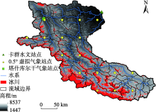
图1
叶尔羌河流域上游河源区概况"

表1
下垫面重分类名称及面积占比"
| 编号 | 名称 | 重分类名称 | 面积占比/% |
|---|---|---|---|
| 12 | 旱地 | AGRR | 0.1 |
| 21 | 有林地 | XJZY | 0.2 |
| 22 | 灌木林 | XJGC | 0.2 |
| 31 | 高覆盖草地 | XJCD | 9.8 |
| 32 | 中覆盖草地 | XJCY | 17.5 |
| 33 | 低覆盖草地 | XJHM | 9.3 |
| 41 | 河渠 | XJHQ | 0.1 |
| 43 | 水库坑塘 | WASK | 0.1 |
| 44 | 永久性冰川雪地 | CNJX | 12.6 |
| 52 | 城镇用地 | URLD | 0.0 |
| 62 | 戈壁 | XJGB | 1.6 |
| 66 | 裸岩石质地 | XJLY | 48.7 |
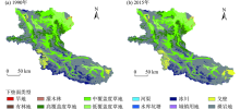
图2
叶尔羌河流域上游河源区下垫面分布"

表2
土壤重分类名称及面积占比"
| 亚类名称 | 土类名称 | 土壤亚类代码 | 重分类名称 | 面积占比/% |
|---|---|---|---|---|
| 寒冻土 | 寒冻土 | 23120171 | HDTXJ | 41.2 |
| 棕钙土 | 棕钙土 | 23113101 | ZGTXJ | 9.2 |
| 淡棕钙土 | 棕钙土 | 23113102 | DGTXJ | 5.4 |
| 棕漠土 | 棕漠土 | 23114121 | ZMTXJ | 3.3 |
| 含盐石质土 | 石质土 | 23115185 | HYSZTXJ | 1.4 |
| 草毡土 | 草毡土 | 23120102 | CZTXJ | 0.9 |
| 寒钙土 | 寒钙土 | 23120122 | HGTXJ | 2.0 |
| 冷钙土 | 冷钙土 | 23120132 | LGTXJ | 18.7 |
| 寒漠土 | 寒漠土 | 23120151 | HMTXJ | 5. 3 |
| 冰川雪被 | 冰川雪被 | 23127101 | ICE | 12. 6 |
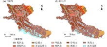
图3
叶尔羌河流域上游河源区土壤类型分布"


图4
研究流程图"

表3
气候和下垫面变化对径流影响的情景设置"
| 情景 | 气候数据年份 | 下垫面数据年份 | 模拟径流结果 |
|---|---|---|---|
| | 1966—1992 | 1990 | Q0 |
| | 1993—2017 | 1990 | Q1 |
| | 1966—1992 | 2015 | Q2 |
| | 1993—2017 | 2015 | Q3 |
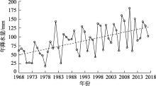
图5
塔什库尔干站年降水量变化趋势"

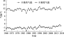
图6
塔什库尔干站日最高、最低气温变化趋势"


图7
卡群站年径流变化趋势"
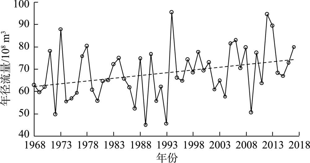
表4
率定参数及其最优值"
| 参数模块 | 参数名称 | 参数意义 | 参数范围 | 参数最优值 |
|---|---|---|---|---|
| 径流 | ESCO | 土壤蒸发补偿系数 | [0.01, 1.0] | 0.6 |
| ALPHA_BF | 基流系数 | [0.1, 1.0] | 0.036 | |
| CH_K2 | 主河道河床有效水力传导度 | [0, 50] | 6.5 | |
| GWQMIN | “基流”水位阈值 | [1, 200] | 100 | |
| GW_DELAY | 地下水延迟时间 | [0, 180] | 60 | |
| 冰川 | FM | 融冰系数 | [2.6, 13] | 5.5 |
| Rice | 冰辐射系数 | [0, 0.1] | 14.4×10⁻⁶ | |
| β0 | 基础蓄积系数 | [0.001, 0.006] | 0.003 | |
| 积雪 | SMFMX | 6月21日融雪度日因子 | [0, 10] | 6.5 |
| SMFMN | 12月21日融雪度日因子 | [0, 10] | 1.0 | |
| SFTMP | 降雪阈值温度 | [-5, +5] | 1.0 | |
| SMTMP | 融雪阈值温度 | [-5, +5] | 0.5 | |
| TIMP | 积雪温度滞后系数 | [0.1, 2.0] | 1.0 |

图8
卡群站月平均流量模拟结果(校准期)"
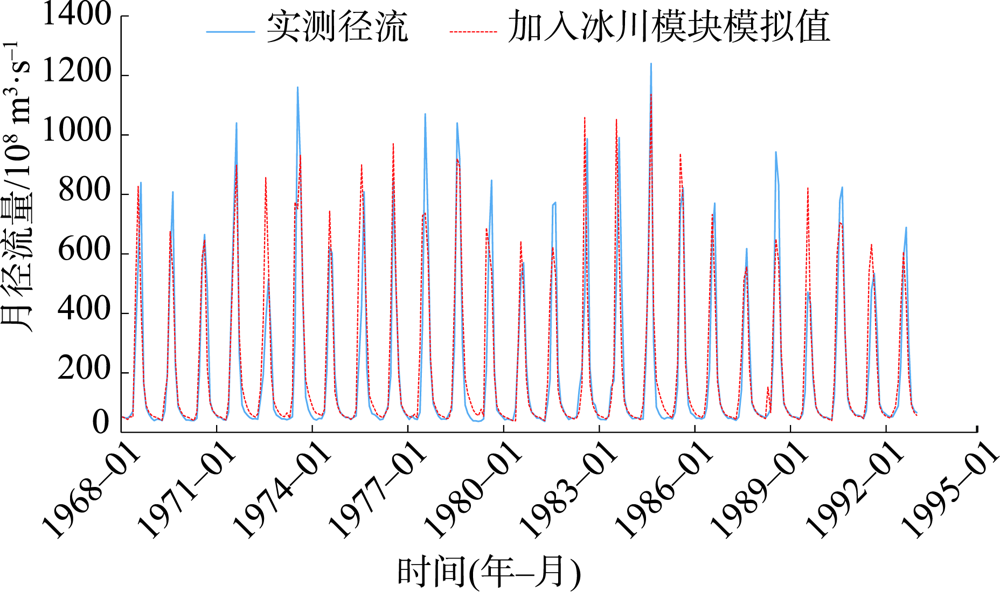
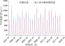
图9
卡群站月平均流量模拟结果(验证期)"
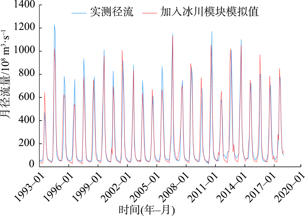
表5
卡群站月平均径流模拟结果评价"
| 时段 | 实测径流均值/m3·s-1 | 模拟径流均值/m3·s-1 | R2 | NSE | RSR | PBIAS/% |
|---|---|---|---|---|---|---|
| 校准期(1968-01—1992-12) | 203.14 | 218.10 | 0.77 | 0.76 | 0.49 | -7.37 |
| 验证期(1993-01—2017-12) | 226.06 | 224.72 | 0.86 | 0.85 | 0.38 | 0.59 |
| 全时段(1968-01—2017-12) | 214.60 | 221.41 | 0.82 | 0.81 | 0.44 | -3.17 |
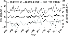
图10
模拟年径流、模拟冰川径流、冰川径流贡献率年际变化趋势"

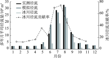
图11
实测径流、模拟径流、冰川径流和冰川径流贡献率年内分布特征"

表6
气候及下垫面变化对径流影响定量分析结果"
| 水文站 | Q0/m3·s-1 | Q1/m3·s-1 | Q2/m3·s-1 | Q3/m3·s-1 | ΔQC/m3·s-1 | ΔQL/m3·s-1 | ΔQC+L/m3·s-1 | βC/% | βL/% | |
|---|---|---|---|---|---|---|---|---|---|---|
| 卡群 | 217.67 | 224.31 | 218.10 | 224.72 | 6.62 | 0.41 | 7.03 | 94.2 | 5.8 | |
| [1] | 杨满根, 陈星. 气候变化对淮河流域中上游汛期极端流量影响的SWAT模拟[J]. 生态学报, 2017, 37(23):8107-8116. |
| [ Yang Mangen, Chen Xing. Effects of climate change on extreme streamflow in flood season in the upper and middle basin of the Huaihe River by SWAT simulation[J]. Acta Ecologica Sinica, 2017, 37(23):8107-8116. ] | |
| [2] |
Brown A E, Zhang L, Mcmahon T A, et al. A review of paired catchment studies for determining changes in water yield resulting from alterations in vegetation[J]. Journal of Hydrology, 2005, 310(1-4):28-61.
doi: 10.1016/j.jhydrol.2004.12.010 |
| [3] | 龙爱华, 邓铭江, 谢蕾, 等. 气候变化下新疆及咸海流域河川径流演变及适应性对策分析[J]. 干旱区地理, 2012, 35(3):377-387. |
| [ Long Aihua, Deng Mingjiang, Xie Lei, et al. Exploring analysis on the adaptive countermeasures to water resources evolvement under the climate change in Xinjiang and Aral Sea Basin[J]. Arid Land Geography, 2012, 35(3):377-387. ] | |
| [4] | 祖拜代·木依布拉, 师庆东, 普拉提·莫合塔尔, 等. 基于SWAT模型的乌鲁木齐河上游土地利用和气候变化对径流的影响[J]. 生态学报, 2018, 38(14):5149-5157. |
| [ Muyibul Zubaida, Shi Qingdong, Muhtar Polat, et al. Land use and climate change effects on runoff in the upper Urumqi River watershed: A SWAT model based analysis[J]. Acta Ecologica Sinica, 2018, 38(14):5149-5157. ] | |
| [5] | 李帅, 魏虹, 刘媛, 等. 气候与土地利用变化下宁夏清水河流域径流模拟[J]. 生态学报, 2017, 37(4):1252-1260. |
| [ Li Shuai, Wei Hong, Liu Yuan, et al. Runoff prediction for Ningxia Qingshui River Basin under scenarios of climate and land use changes[J]. Acta Ecologica Sinica, 2017, 37(4):1252-1260. ] | |
| [6] | 秦文静, 王云琦, 王彬, 等. 土地利用和气候变化对王家桥小流域径流的影响[J]. 水文, 2019, 39(2):49-54. |
| [ Qin Wenjing, Wang Yunqi, Wang Bin, et al. Impacts of land use and climate change on runoff in Wangjiaqiao Watershed[J]. Journal of China Hydrology, 2019, 39(2):49-54. ] | |
| [7] | 袁宇志, 张正栋, 蒙金华. 基于SWAT模型的流溪河流域土地利用与气候变化对径流的影响[J]. 应用生态学报, 2015, 26(4):989-998. |
| [ Yuan Yuzhi, Zhang Zhengdong, Meng Jinhua, et al. Impact of changes in land use and climate on the runoff in Liuxihe Watershed based on SWAT model[J]. Chinese Journal of Applied Ecology, 2015, 26(4):989-998. ] | |
| [8] | 尹振良, 肖洪浪, 邹松兵, 等. 祁连山黑河干流山区水文模拟研究进展[J]. 冰川冻土, 2013, 35(2):438-446. |
| [ Yin Zhenliang, Xiao Honglang, Zou Songbing, et al. Progress of research on hydrological simulation in the mainstream of the Heihe River, Qilian Mountains[J]. Journal of Glaciology and Geocryology, 2013, 35(2):438-446. ] | |
| [9] |
Rahman K, Etienne C, Gago-Silva A, et al. Streamflow response to regional climate model output in the mountainous watershed: A case study from the Swiss Alps[J]. Environmental Earth Sciences, 2014, 72(11):4357-4369.
doi: 10.1007/s12665-014-3336-0 |
| [10] | 郭军庭, 张志强, 王盛萍, 等. 应用SWAT模型研究潮河流域土地利用和气候变化对径流的影响[J]. 生态学报, 2014, 34(6):1559-1567. |
| [ Guo Junting, Zhang Zhiqiang, Wang Shengping, et al. Appling SWAT model to explore the impact of changes in land use and climate on the streamflow in a watershed of northern China[J]. Acta Ecologica Sinica, 2014, 34(6):1559-1567. ] | |
| [11] | 赵杰, 徐长春, 高沈瞳, 等. 基于SWAT模型的乌鲁木齐河流域径流模拟[J]. 干旱区地理, 2015, 38(4):666-674. |
| [ Zhao Jie, Xu Changchun, Gao Shentong, et al. Hydrological modeling in the Urumqi River Basin based on SWAT[J]. Arid Land Geography, 2015, 38(4):666-674. ] | |
| [12] | 刘全諹, 齐明亮, 马啸宙, 等. 基于遥感和 GIS 的洮河流域面源污染流域尺度模拟及防治对策研究[J]. 干旱区地理, 2020, 43(3):706-714. |
| [ Liu Quanyang, Qi Mingliang, Ma Xiaozhou, et al. SWAT simulation and countermeasures of non-point source pollution based on remote sensing and GIS in Taohe River Basin[J]. Arid Land Geography, 2020, 43(3):706-714. ] | |
| [13] | 祁敏, 张超. 基于SWAT模型的阿克苏河流域径流模拟[J]. 水土保持研究, 2017, 24(3):283-287. |
| [ Qi Min, Zhang Chao. Runoff simulation in Aksu River Basin based on SWAT model[J]. Research of Soil and Water Conservation, 2017, 24(3):283-287. ] | |
| [14] | 张一驰, 李宝林, 包安明, 等. 开都河流域融雪径流模拟研究[J]. 中国科学: 地球科学, 2006, 36(增刊2):24-32. |
| [ Zhang Yichi, Li Baolin, Bao Anming, et al. Simulation study on snowmelt runoff in Kaidu River Basin[J]. Scientia Sinica (Terrae), 2006, 36(Suppl. 2):24-32. ] | |
| [15] | 黄粤, 陈曦, 包安明, 等. 干旱区资料稀缺流域日径流过程模拟[J]. 水科学进展, 2009, 20(3):332-336. |
| [ Huang Yue, Chen Xi, Bao Anming, et al. Daily flow modeling in arid ungauged basin[J]. Advances in Water Science, 2009, 20(3):332-336. ] | |
| [16] | 黄粤, 陈曦, 包安明, 等. 开都河流域山区径流模拟及降雨输入的不确定性分析[J]. 冰川冻土, 2010, 32(3):567-572. |
| [ Huang Yue, Chen Xi, Bao Anming, et al. Distributed hydrological modeling in Kaidu Basin: MIKE-SHE model calibration and uncertainty estimation[J]. Journal of Glaciology and Geocryology, 2010, 32(3):567-572. ] | |
| [17] | 王鹏, 姜卉芳, 穆振侠. 阿克苏河源流径流模拟初探[J]. 水资源与水工程学报, 2012, 23(3):51-54, 57. |
| [ Wang Peng, Jiang Huifang, Mu Zhenxia. Simulation of runoff process in headstream of Aksu River[J]. Journal of Water Resources and Water Engineering, 2012, 23(3):51-54, 57. ] | |
| [18] | 罗敏, 刘铁, 黄粤, 等. 未来气候情景下和田河流域日径流过程模拟[J]. 水资源与水工程学报, 2016, 27(2):11-17. |
| [ Luo Min, Liu Tie, Huang Yue, et al. Simulation of daily runoff process in Hotan River Basin under scenario of future climate[J]. Journal of Water Resources and Water Engineering, 2016, 27(2):11-17. ] | |
| [19] | 陈亚宁, 杨青, 罗毅, 等. 西北干旱区水资源问题研究思考[J]. 干旱区地理, 2012, 35(1):1-9. |
| [ Chen Yaning, Yang Qing, Luo Yi, et al. Ponder on the issues of water resources in the arid region of northwest China[J]. Arid Land Geography, 2012, 35(1):1-9. ] | |
| [20] | 刘蛟, 刘晓辉, 刘铁, 等. 驱动数据对流域水文模拟中不同结果要素的影响[J]. 自然资源学报, 2019, 34(11):2481-2490. |
| [ Liu Jiao, Liu Xiaohui, Liu Tie, et al. The impacts of input data on different simulated results in hydrological modelling[J]. Journal of Natural Resources, 2019, 34(11):2481-2490. ] | |
| [21] | 陈昱凝, 胡林金, 颜伟, 等. 叶尔羌河上游不同流域夏季气候和径流变化研究[J]. 冰川冻土, 2014, 36(3):678-684. |
| [ Chen Yuning, Hu Linjin, Yan Wei, et al. Study of the changes in summer climate and runoff in two upper streams of the Yarkant River[J]. Journal of Glaciology and Geocryology, 2014, 36(3):678-684. ] | |
| [22] | 陈亚宁, 徐长春, 郝兴明, 等. 新疆塔里木河流域近50 a气候变化及其对径流的影响[J]. 冰川冻土, 2008, 30(6):921-929. |
| [ Chen Yaning, Xu Changchun, Hao Xingming, et al. Fifty-year climate change and its effect on annual runoff in the Tarim River Basin, China[J]. Journal of Glaciology and Geocryology, 2008, 30(6):921-929. ] | |
| [23] | Zhao Y F, Zhu J. Assessing quality of grid daily precipitation datasets in China in recent 50 years[J]. Plateau Meteorology, 2015, 34(1):50-58. |
| [24] | 刘启宁, 辛卓航, 韩建旭, 等. 变化环境下东北半干旱地区径流演变规律分析--以洮儿河流域为例[J]. 水力发电学报, 2020, 39(5):51-63. |
| [ Liu Qining, Xin Zhuohang, Han Jianxu, et al. Analysis on the evolution mechanisms of streamflow in semi-arid region in northeast China under the changing environment: A case study in Taoer River Basin[J]. Journal of Hydroelectric Engineering, 2020, 39(5):51-63. ] | |
| [25] | 吴用, 李畅游, 张成福, 等. 基于ArcGIS和SWAT的山区、平原区复合地貌流域划分方法研究[J]. 干旱区地理, 2016, 39(2):413-419. |
| [ Wu Yong, Li Changyou, Zhang Chengfu, et al. A watershed delineation method for mountains, plains complex landform area based on ArcGIS and SWAT[J]. Arid Land Geography, 2016, 39(2):413-419. ] | |
| [26] | 龙爱华, 邹松兵, 许宝荣, 等. SWAT 2009理论基础[M]. 郑州: 黄河水利出版社, 2012: 1-378. |
| [ Long Aihua, Zou Songbing, Xu Baorong, et al. Soil and water assessment tool theoretical documentation version 2009[M]. Zhengzhou: Yellow River Water Conservancy Press, 2012: 1-378. ] | |
| [27] |
Neupane P, Bailey R T, Tavaloil-Kivi S. Assessing controls on selenium fate and transport in watersheds using the SWAT model[J]. Science of the Total Environment, 2020, 738:140318, doi: 10. 1016/j.scitotenv.2020.140318.
doi: 10. 1016/j.scitotenv.2020.140318 |
| [28] |
Ying Z L, Feng Q, Liu S Y, et al. The spatial and temporal contribution of glacier runoff to watershed discharge in the Yarkant River Basin, northwest China[J]. Water, 2017, 9(3):159.
doi: 10.3390/w9030159 |
| [29] | Moriasi D N, Arnold J G, Liew M, et al. Model evaluation guidelines for systematic quantification of accuracy in watershed simulations[J]. Transactions of the Asabe, 2007, 50(3):855-900. |
| [30] |
Zhang Y, Liu S Y, Ding Y J. Observed degree-day factors and their spatial variation on glaciers in western China[J]. Annals of Glaciology, 2006, 43(1):301-306.
doi: 10.3189/172756406781811952 |
| [31] |
Dubey S, Goyal M K. Glacial lake outburst flood hazard, downstream impact, and risk over the Indian Himalayas[J]. Water Resources Research, 2020, 56(4): e2019wr026533, doi: 10.1029/2019wr026533.
doi: 10.1029/2019wr026533 |
| [32] |
Luo Y, Arnold J, Liu S Y, et al. Inclusion of glacier processes for distributed hydrological modeling at basin scale with application to a watershed in Tianshan Mountains, northwest China[J]. Journal of Hydrology, 2013, 477:72-85.
doi: 10.1016/j.jhydrol.2012.11.005 |
| [33] | 王鹏赫, 赵成义, 王丹丹, 等. 气候变化对叶尔羌河流域极端水文事件的影响[J]. 生态科学, 2018, 37(6):1-8. |
| [ Wang Penghe, Zhao Chengyi, Wang Dandan, et al. Influence of climate change on hydrological extremes of Yarkant River Basin[J]. Ecological Science, 2018, 37(6):1-8. ] | |
| [34] |
Gao X, Ye B S, Zhang S Q, et al. Glacier runoff variation and its influence on river runoff during 1961-2006 in the Tarim River Basin, China[J]. Science China Earth Science, 2010, 53:880-891.
doi: 10.1007/s11430-010-0073-4 |
| [35] | 魏天锋, 刘志辉, 姚俊强, 等. 呼图壁河径流过程对气候变化的响应[J]. 干旱区资源与环境, 2015, 29(4):102-107. |
| [ Wei Tianfeng, Liu Zhihui, Yao Junqiang, et al. Response of Hutubi River runoff process on climate change[J]. Journal of Arid Land Resources and Environment, 2015, 29(4):102-107. ] | |
| [36] | 赵悦. 水利工程项目质量管理研究[D]. 长春: 吉林大学, 2017. |
| [ Zhao Yue. Research on quality management of water conservancy projects[D]. Changchun: Jilin University, 2017. ] | |
| [37] | 薛宝林, 张瀚文, 闫宇会, 等. 黄垒河流域气候与土地利用变化对径流的影响[J]. 北京师范大学学报(自然科学版), 2020, 56(3):445-453. |
| [ Xue Baolin, Zhang Hanwen, Yan Yuhui, et al. Impact of climate and land use change on runoff in Huanglei River Basin[J]. Journal of Beijing Normal University (Natural Science Edition), 2020, 56(3):445-453. ] | |
| [38] | Guo J T, Zhang Z Q, Wang S P, et al. Appling SWAT model to explore the impact of changes in land use and climate on the streamflow in a watershed of northern China[J]. Acta Ecologica Sinica, 2014, 34(6):1559-1567. |
| [39] |
Ying Z L, Xiao H L, Zou S B, et al. Simulation of hydrological processes of mountainous watersheds in inland river basins: Taking the Heihe Mainstream River as an example[J]. Journal of Arid Land, 2014, 6(1):16-26.
doi: 10.1007/s40333-013-0197-4 |
| [40] | 刘志斌, 黄粤, 刘铁, 等. 开都河源区径流变化的气候响应[J]. 干旱区研究, 2020, 37(2):418-427. |
| [ Liu Zhibin, Huang Yue, Liu Tie, et al. Climate response of runoff variation in the source area of the Kaidu River[J]. Arid Zone Research, 2020, 37(2):418-427. ] |
| [1] | 隋露, 闫志明, 李开放, 何佩恩, 马英杰, 张汝萃. 人类活动及气候变化影响下伊犁河谷生境质量预测研究[J]. 干旱区地理, 2024, 47(1): 104-116. |
| [2] | 田昊玮, 陈伏龙, 龙爱华, 刘静, 海洋. 博尔塔拉河源流区径流对气候变化的响应及预测[J]. 干旱区地理, 2023, 46(9): 1432-1442. |
| [3] | 艾丽亚, 王永芳, 郭恩亮, 银山, 顾锡羚. 基于GEE的大青山国家级自然保护区NDVI变化及影响因素分析[J]. 干旱区地理, 2023, 46(8): 1279-1290. |
| [4] | 高晓宇, 郝海超, 张雪琪, 陈亚宁. 中国西北干旱区植被水分利用效率变化对气象要素的响应——以新疆为例[J]. 干旱区地理, 2023, 46(7): 1111-1120. |
| [5] | 顾朝林, 苏鹤放, 顾江, 高喆, 陈乐琳, 郭力. 论地球科学的新时代[J]. 干旱区地理, 2023, 46(7): 1176-1195. |
| [6] | 陈淑君,许国昌,吕志平,马铭悦,李晗羽,朱玉岩. 中国植被覆盖度时空演变及其对气候变化和城市化的响应[J]. 干旱区地理, 2023, 46(5): 742-752. |
| [7] | 李娜,武永利,赵桂香,钱锦霞,李芬,赵海英,韩普. 近60 a山西省极端气温事件的年际变化及其对区域增暖的响应[J]. 干旱区地理, 2023, 46(3): 337-348. |
| [8] | 任涛涛,李双双,段克勤,何锦屏. 黄土高原热浪型和缺水型骤旱时空变化特征及其影响因素[J]. 干旱区地理, 2023, 46(3): 360-370. |
| [9] | 晋子振, 秦翔, 赵求东, 李延召, 刘宇硕, 陈记祖, 王利辉, 王强. 祁连山西段老虎沟流域消融季径流变化特征研究[J]. 干旱区地理, 2023, 46(2): 178-190. |
| [10] | 曹晓云,肖建设,郝晓华,史飞飞,刘致远,李素雲. 2001—2020年三江源地区积雪日数变化及地形分异[J]. 干旱区地理, 2022, 45(5): 1370-1380. |
| [11] | 梁鹏飞,辛惠娟,李宗省,张百娟,桂娟,段然,南富森,丁增扬平,杨盛梅. 祁连山黑河径流变化特征及影响因素研究[J]. 干旱区地理, 2022, 45(5): 1460-1471. |
| [12] | 胡可可,何建村,赵健,苏里坦,张音. 气候变化背景下尼雅河流域生态基流研究[J]. 干旱区地理, 2022, 45(5): 1472-1480. |
| [13] | 姚旭阳,张明军,张宇,王家鑫,肖涵余. 中国西北地区气候转型的新认识[J]. 干旱区地理, 2022, 45(3): 671-683. |
| [14] | 苏玥,张存厚,阿木尔萨那,李轲. 1981—2018年内蒙古典型草原季节性冻土对气候变化的响应[J]. 干旱区地理, 2022, 45(3): 684-694. |
| [15] | 王雅琴,杨海梅,范文波,许忠宇,乔长录. 近50 a新疆风蚀气候侵蚀力迁移特征及影响因素研究[J]. 干旱区地理, 2022, 45(2): 370-378. |
|
||