| [1] |
钟士恩, 陆文镔, 彭红松, 等. 红领巾儿童对红色旅游资源与爱国主义的认知——雨花台烈士陵园案例实证及启示[J]. 自然资源学报, 2021, 36(7): 1684-1699.
doi: 10.31497/zrzyxb.20210705
|
|
[Zhong Shi’en, Lu Wenbin, Peng Hongsong, et al. Red scarf children’s cognition of red tourism resources and patriotism: Evidence from Yuhuatai revolutionary martyrs memorial area in Nanjing[J]. Journal of Natural Resources, 2021, 36(7): 1684-1699. ]
doi: 10.31497/zrzyxb.20210705
|
| [2] |
邹建琴, 明庆忠, 刘安乐, 等. 中国红色旅游经典景点空间分布格局及其影响因素异质性[J]. 自然资源学报, 2021, 36(11): 2748-2762.
doi: 10.31497/zrzyxb.20211103
|
|
[Zou Jianqin, Ming Qingzhong, Liu Anle, et al. Spatial distribution pattern of classic red tourism scenic spots and heterogeneity of its influencing factors in China[J]. Journal of Natural Resources, 2021, 36(11): 2748-2762. ]
doi: 10.31497/zrzyxb.20211103
|
| [3] |
张新成, 高楠, 王琳艳, 等. 红色旅游高质量发展评价指标体系与培育路径研究——以红色旅游城市为例[J]. 干旱区地理, 2022, 45(6): 1927-1937.
|
|
[Zhang Xincheng, Gao Nan, Wang Linyan, et al. Evaluation index system and cultivation path of high-quality development of red tourism: A case of red tourist cities[J]. Arid Land Geography, 2022, 45(6): 1927-1937. ]
|
| [4] |
刘润佳, 黄震方, 余润哲, 等. 红色旅游对游客国家认同的影响[J]. 自然资源学报, 2021, 36(7): 1673-1683.
doi: 10.31497/zrzyxb.20210704
|
|
[Liu Runjia, Huang Zhenfang, Yu Runzhe, et al. The impact of red tourism on national identity of tourists[J]. Journal of Natural Resources, 2021, 36(7): 1673-1683. ]
doi: 10.31497/zrzyxb.20210704
|
| [5] |
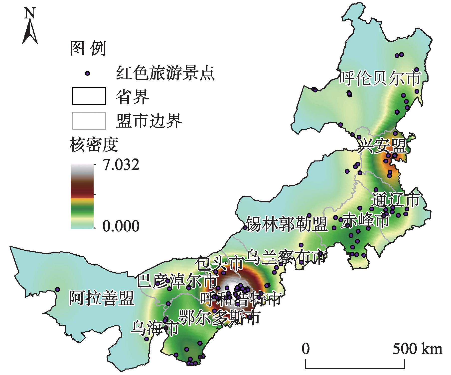
周海涛, 张雨惠, 宁小莉, 等. 内蒙古A级旅游景区时空分异特征及影响因素[J]. 干旱区资源与环境, 2021, 35(12): 202-208.
|
|
[Zhou Haitao, Zhang Yuhui, Ning Xiaoli, et al. Spatial-temporal differentiation characteristics of A class tourist attractions in Inner Mongolia[J]. Journal of Arid Land Resources and Environment, 2021, 35(12): 202-208. ]
|
| [6] |
陈国磊, 张春燕, 罗静, 等. 中国红色旅游经典景区空间分布格局[J]. 干旱区资源与环境, 2018, 32(9): 196-202.
|
|
[Chen Guolei, Zhang Chunyan, Luo Jing, et al. Spatial distribution pattern of classical red tourism scenic spots in China[J]. Journal of Arid Land Resources and Environment, 2018, 32(9): 196-202. ]
|
| [7] |
熊杰, 章锦河, 周臖, 等. 中国红色旅游景点的时空分布特征[J]. 地域研究与开发, 2018, 37(2): 83-88.
|
|
[Xiong Jie, Zhang Jinhe, Zhou Jun, et al. Spatial-temporal distribution characteristics of red-tourism attractions in China[J]. Areal Research and Development, 2018, 37(2): 83-88. ]
|
| [8] |
邓伟, 谭琳, 杨才, 等. 中国山地红色旅游资源类型、分布与高质量开发[J]. 山地学报, 2021, 39(2): 163-173.
|
|
[Deng Wei, Tan Lin, Yang Cai, et al. Types, distribution and high-efficiency exploitation of red tourism resources in mountainous areas of China[J]. Mountain Research, 2021, 39(2): 163-173. ]
|
| [9] |
王金伟, 王国权, 刘乙, 等. 井冈山红色旅游流时空分布及网络结构特征[J]. 自然资源学报, 2021, 36(7): 1777-1791.
doi: 10.31497/zrzyxb.20210711
|
|
[Wang Jinwei, Wang Guoquan, Liu Yi, et al. Spatio-temporal distribution and network structure of red tourism flow in Jinggangshan[J]. Journal of Natural Resources, 2021, 36(7): 1777-1791. ]
doi: 10.31497/zrzyxb.20210711
|
| [10] |
王钊, 黄文杰. 长征红色旅游景区的演化及其形成机制研究[J]. 经济地理, 2021, 41(11): 209-217.
|
|
[Wang Zhao, Huang Wenjie. The evolution and formation mechanism of red tourism attractions in Long March[J]. Economic Geography, 2021, 41(11): 209-217. ]
|
| [11] |
王美霞, 蒋才芳, 王永明, 等. 基于公路交通网的武陵山片区旅游景点可达性格局分析[J]. 经济地理, 2014, 34(6): 187-192.
doi: 10.2307/142305
|
|
[Wang Meixia, Jiang Caifang, Wang Yongming, et al. Accessibility analysis of scenic spots in Wuling mountainous area based on road traffic network[J]. Economic Geography, 2014, 34(6): 187-192. ]
doi: 10.2307/142305
|
| [12] |
赵鹏军, 罗佳, 胡昊宇. 基于大数据的生活圈范围与服务设施空间匹配研究——以北京为例[J]. 地理科学进展, 2021, 40(4): 541-553.
doi: 10.18306/dlkxjz.2021.04.001
|
|
[Zhao Pengjun, Luo Jia, Hu Haoyu. Spatial match between residents’ daily life circle and public service facilities using big data analytics: A case of Beijing[J]. Progress in Geography, 2021, 40(4): 541-553. ]
doi: 10.18306/dlkxjz.2021.04.001
|
| [13] |
翟石艳, 何新新, 孔云峰, 等. 基于最优供需分配的公共设施空间可达性分析[J]. 地理学报, 2022, 77(4): 1028-1038.
doi: 10.11821/dlxb202204017
|
|
[Zhai Shiyan, He Xinxin, Kong Yunfeng, et al. Measuring the spatial accessibility of public services by optimal supply-demand allocation[J]. Acta Geographica Sinica, 2022, 77(4): 1028-1038. ]
doi: 10.11821/dlxb202204017
|
| [14] |
任家怿, 王云. 基于改进两步移动搜索法的上海市黄浦区公园绿地空间可达性分析[J]. 地理科学进展, 2021, 40(5): 774-783.
doi: 10.18306/dlkxjz.2021.05.005
|
|
[Ren Jiayi, Wang Yun. Spatial accessibility of park green space in Huangpu District of Shanghai based on modified two-step floating catchment area method[J]. Progress in Geography, 2021, 40(5): 774-783. ]
doi: 10.18306/dlkxjz.2021.05.005
|
| [15] |
杨友宝, 邓巧. 湖南省红色村落空间分布格局及公路可达性研究[J]. 长江流域资源与环境, 2022, 31(4): 793-804.
|
|
[Yang Youbao, Deng Qiao. Study on the spatial distribution pattern and highway accessibility of red villages in Hunan Province[J]. Resources and Environment in the Yangtze Basin, 2022, 31(4): 793-804. ]
|
| [16] |
陈阳, 张琳琳, 马仁锋, 等. 城市绿色空间可达性与居民分布的空间匹配与影响因素[J]. 生态学报, 2022, 42(24): 9971-9980.
|
|
[Chen Yang, Zhang Linlin, Ma Renfeng, et al. Spatial match between urban residents’ distribution and green accessibility and its driving force[J]. Acta Ecologica Sinica, 2022, 42(24): 9971-9980. ]
|
| [17] |
李小璨, 阿荣, 佟宝全. 呼和浩特市生活性服务业空间布局特征及评价[J]. 干旱区地理, 2021, 44(4): 1186-1197.
|
|
[Li Xiaocan, A Rong, Tong Baoquan. Characteristics and evaluation of the spatial distribution of life service industry in Hohhot City[J]. Arid Land Geography, 2021, 44(4): 1186-1197. ]
|
| [18] |
苏都尔, 那顺达来, 其力木格, 等. 基于GIS的内蒙古半农半牧区地名景观空间分布特征研究[J]. 干旱区地理, 2020, 43(6): 1648-1656.
|
|
[ Suduer, Nashundalai, Qilimuge, et al. Spatial distribution of place-names in farming-pastoral region based on GIS: A case study of Jarud Banner, Inner Mongolia[J]. Arid Land Geography, 2020, 43(6): 1648-1656. ]
|
| [19] |
王劲峰, 徐成东. 地理探测器:原理与展望[J]. 地理学报, 2017, 72(1): 116-134.
doi: 10.11821/dlxb201701010
|
|
[Wang Jinfeng, Xu Chengdong. Geodetector: Principle and prospective[J]. Acta Geographica Sinica, 2017, 72(1): 116-134. ]
doi: 10.11821/dlxb201701010
|
| [20] |
艾廷华, 雷英哲, 谢鹏, 等. 等时线模型支持下的深圳市综合医院空间可达性测度分析[J]. 地球信息科学学报, 2020, 22(1): 113-121.
doi: 10.12082/dqxxkx.2020.190470
|
|
[Ai Tinghua, Lei Yingzhe, Xie Peng, et al. Quantifying spatial accessibility of Shenzhen’s hospitals by the isochrone model[J]. Journal of Geo-information Science, 2020, 22(1): 113-121. ]
doi: 10.12082/dqxxkx.2020.190470
|
 ),马钰松1,樊亚宇1,宁小莉1(