Arid Land Geography ›› 2024, Vol. 47 ›› Issue (8): 1263-1276.doi: 10.12118/j.issn.1000-6060.2024.166
• The Third Xinjiang Scientific Expedition • Previous Articles Next Articles
LI Zhi1( ), ZHU Chenggang1(), WANG Jiayou1,2, LIU Yongchang1,2, WANG Chuan1,2, ZHANG Xueqi1, HAN Shiru1,2, FANG Gonghuan1
Received:2024-03-13
Revised:2024-03-26
Online:2024-08-25
Published:2024-09-02
Contact:
ZHU Chenggang
E-mail:liz@ms.xjb.ac.cn;zhuchg@ms.xjb.ac.cn
LI Zhi, ZHU Chenggang, WANG Jiayou, LIU Yongchang, WANG Chuan, ZHANG Xueqi, HAN Shiru, FANG Gonghuan. Estimation of evaporation loss from typical lakes in the Kumukuli Basin, East Kunlun Mountains[J].Arid Land Geography, 2024, 47(8): 1263-1276.
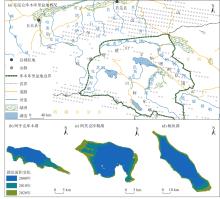
Fig. 1
Schematic diagram of the study area"

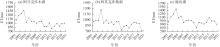
Fig. 2
Interannual change in actual evapotranspiration of the three typical lakes from 2001 to 2020"

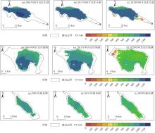
Fig. 3
Spatial distribution of mean actual evapotranspiration in the three typical lakes from 2001 to 2020"


Fig. 4
Spatial distribution of trend values of actual evapotranspiration of the three typical lakes from 2001 to 2020"
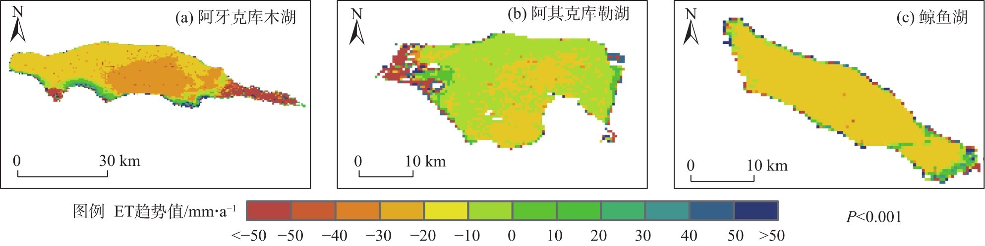
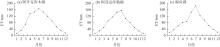
Fig. 5
Changes of monthly actual evapotranspiration in the three typical lakes from 2001 to 2020"
Fig. 6
Changes of annual lake area and evaporated water quantity of the three typical lakes from 2001 to 2020"

Fig. 7
Importance of evaporation influencing factors in Ayakkum Lake"
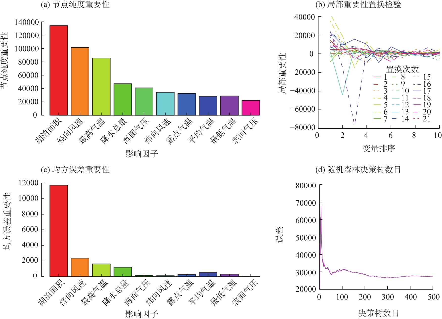

Fig. 8
Importance of evaporation influencing factors in Aqqikkol Lake"


Fig. 9
Importance of evaporation influencing factors in Whale Lake"

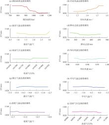
Fig. 10
Dependence of evaporation influencing factors in Ayakkum Lake"
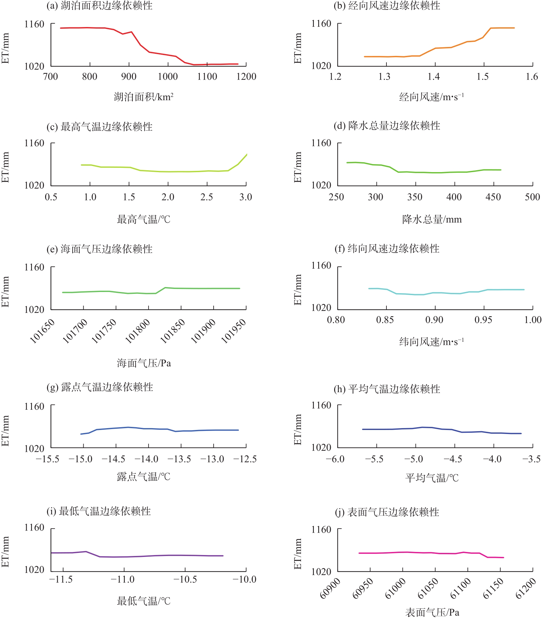
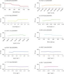
Fig. 11
Dependence of evaporation influencing factors in Aqqikkol Lake"
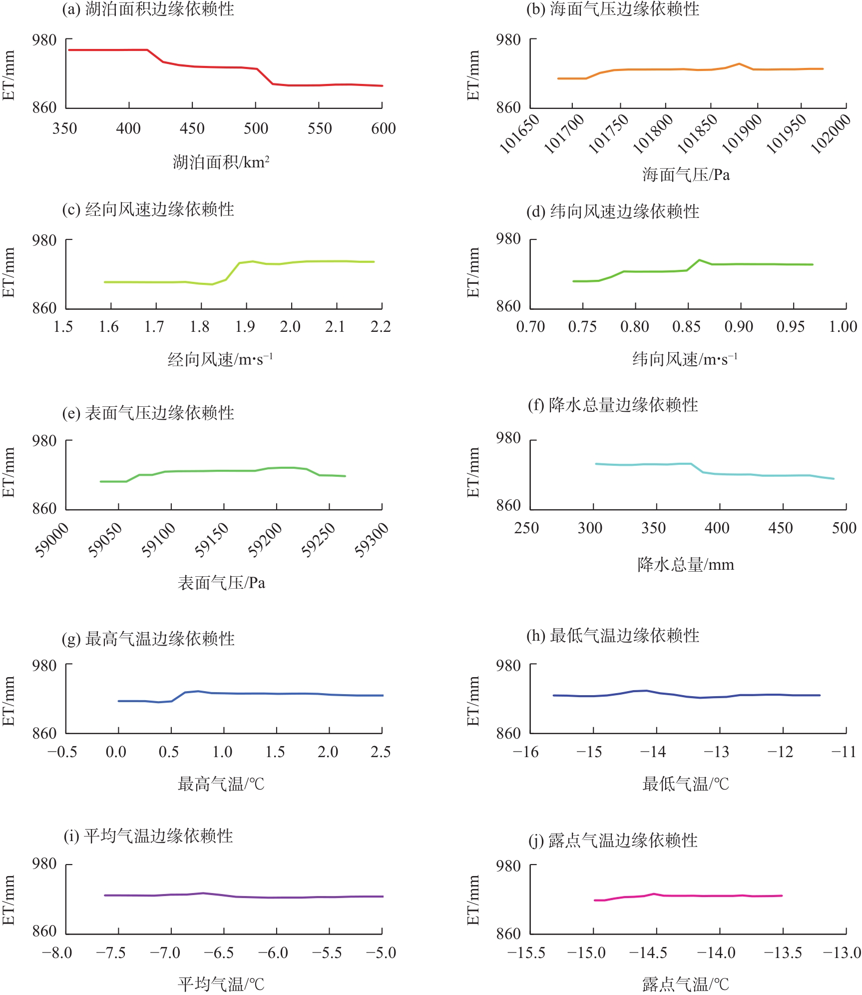
Fig. 12
Dependence of factors on evaporation in Whale Lake"

| [1] | Steingruber S M, Bernasconi S M, Valenti G. Climate change-induced changes in the chemistry of a high-altitude mountain lake in the Central Alps[J]. Aquatic Geochemistry, 2021, 27(2): 105-126. |
| [2] | Zhao G, Gao H. Estimating reservoir evaporation losses for the United States: Fusing remote sensing and modeling approaches[J]. Remote Sensing of Environment, 2019(226): 109-124. |
| [3] | Wang W, Lee X, Xiao W, et al. Global lake evaporation accelerated by changes in surface energy allocation in a warmer climate[J]. Nature Geoscience, 2018, 11(6): 410-414. |
| [4] | Ali S, Ghosh N C, Singh R. Evaluating best evaporation estimate model for water surface evaporation in semi-arid region, India[J]. Hydrological Processes: An International Journal, 2008, 22(8): 1093-1106. |
| [5] | Morton F I. Climatological estimates of lake evaporation[J]. Water Resources Research, 1979, 15(1): 64-76. |
| [6] | 艾尔肯·图尔荪, 玉素甫江·如素力, 崔一爽, 等. 2000—2019年新疆大型湖泊湖冰物候时空变化特征[J]. 干旱区地理, 2022, 45(5): 1440-1449. |
| [Tuersun Aierken, Rusuli Yusufujiang, Cui Yishuang, et al. Temporal and spatial variations of lake ice phenology in large lakes of Xinjiang from 2000 to 2019[J]. Arid Land Geography, 2022, 45(5): 1440-1449.] | |
| [7] | Cai Y, Ke C Q, Yao G H, et al. MODIS-observed variations of lake ice phenology in Xinjiang, China[J]. Climatic Change, 2020, 158(3): 575-592. |
| [8] | 于革, 赖格英, 薛滨, 等. 中国西部湖泊水量对未来气候变化的响应——蒙特卡罗概率法在气候模拟输出的应用[J]. 湖泊科学, 2004, 16(3): 193-202. |
| [Yu Ge, Lai Geying, Xue Bin, et al. Preliminary study on the responses of lake water from the western China to climate change in the future: Monte Carlo analysis applied in GCM simulations and lake water changes[J]. Journal of Lake Sciences, 2004, 16(3): 193-202.] | |
| [9] | Zhang G, Bolch T, Yao T, et al. Underestimated mass loss from lake-terminating glaciers in the greater Himalaya[J]. Nature Geoscience, 2023, 16(4): 333-338. |
| [10] | Zhang H, Gorelick S M, Zimba P V, et al. A remote sensing method for estimating regional reservoir area and evaporative loss[J]. Journal of Hydrology, 2017, 555: 213-227. |
| [11] | Maestre-Valero J F, Martínez-Granados D, Martínez-Alvarez V, et al. Socio-economic impact of evaporation losses from reservoirs under past, current and future water availability scenarios in the semi-arid Segura Basin[J]. Water Resources Management, 2013(27): 1411-1426. |
| [12] | Friedrich K, Grossman R L, Huntington J, et al. Reservoir evaporation in the Western United States: Current science, challenges, and future needs[J]. Bulletin of the American Meteorological Society, 2018, 99(1): 167-187. |
| [13] | Li Z, Chen Y N, Shen Y J, et al. Analysis of changing pan evaporation in the arid region of Northwest China[J]. Water Resources Research, 2013, 49(4): 2205-2212. |
| [14] | McMahon T A, Peel M C, Lowe L, et al. Estimating actual, potential, reference crop and pan evaporation using standard meteorological data: A pragmatic synthesis[J]. Hydrology and Earth System Sciences, 2013, 17(4): 1331-1363. |
| [15] | Zhang Z, Zhang M, Cao C, et al. A dataset of microclimate and radiation and energy fluxes from the Lake Taihu eddy flux network[J]. Earth System Science Data, 2020, 12(4): 2635-2645. |
| [16] | Moran M S, Jackson R D. Assessing the spatial distribution of evapotranspiration using remotely sensed inputs[J]. Journal of Environmental Quality, 1991, 20(4): 725-737. |
| [17] | Harbeck G E. A practical field technique for measuring reservoir evaporation utilizing mass-transfer theory[M]. Washington: US Government Printing Office, 1962. |
| [18] | Penman H L. Natural evaporation from open water, bare soil and grass[J]. Proceedings Royal Society of London: Series A. Mathematical and Physical Sciences, 1948, 193(1032): 120-145. |
| [19] | Giadrossich F, Niedda M, Cohen D, et al. Evaporation in a Mediterranean environment by energy budget and Penman methods, Lake Baratz, Sardinia, Italy[J]. Hydrology and Earth System Sciences, 2015(19): 2451-2468. |
| [20] | El-Mahdy M E S, Abbas M S, Sobhy H M. Development of mass-transfer evaporation model for Lake Nasser, Egypt[J]. Journal of Water and Climate Change, 2021, 12(1): 223-237. |
| [21] | Gao H. Satellite remote sensing of large lakes and reservoirs: From elevation and area to storage[J]. Wiley Interdisciplinary Reviews: Water, 2015, 2(2): 147-157. |
| [22] | Rosenberry D O, Winter T C, Buso D C, et al. Comparison of 15 evaporation methods applied to a small mountain lake in the northeastern USA[J]. Journal of Hydrology, 2007, 340(3-4): 149-166. |
| [23] | McJannet D L, Cook F J, Burn S. Comparison of techniques for estimating evaporation from an irrigation water storage[J]. Water Resources Research, 2013, 49(3): 1415-1428. |
| [24] | 柯长青. 湖泊遥感研究进展[J]. 海洋湖沼通报, 2004(4): 81-86. |
| [Ke Changqing. A review of monitoring lake environment change by means of remote sensing[J]. Transactions of Oceanology and Limnology, 2004(4): 81-86.] | |
| [25] | Zhang Y, Kong D, Gan R, et al. Coupled estimation of 500 m and 8-day resolution global evapotranspiration and gross primary production in 2002—2017[J]. Remote Sensing Environment, 2019, 222, 165-182. |
| [26] | Lu H, Zhao R, Zhao L, et al. A contrarian growth: The spatiotemporal dynamics of open-surface water bodies on the northern slope of Kunlun Mountains[J]. Ecological Indicators, 2023, 157, 111249, doi: 10.1016/j.ecolind.2023.111249. |
| [27] | 刘鸿波, 董理, 严若婧, 等. ERA5 再分析资料对中国大陆区域近地层风速气候特征及变化趋势再现能力的评估[J]. 气候与环境研究, 2021, 26(3): 299-311. |
| [Liu Hongbo, Dong Li, Yan Ruojing, et al. Evaluation of near-surface wind speed climatology and long-term trend over China’s mainland region based on ERA5 reanalysis[J]. Climatic and Environmental Research, 2021, 26(3): 299-311.] | |
| [28] | 刘婷婷, 朱秀芳, 郭锐, 等. ERA5再分析降水数据在中国的适用性分析[J]. 干旱区地理, 2022, 45(1): 66-79. |
| [Liu Tingting, Zhu Xiufang, Guo Rui, et al. Applicability of ERA5 reanalysis of precipitation data in China[J]. Arid Land Geography, 2022, 45(1): 66-79.] | |
| [29] | Breiman L. Random forests[J]. Machine Learning, 2001, 45(1): 5-32. |
| [30] | Zhang Q, Zhang G, Zhang Y, et al. Coupling GEDI LiDAR and optical satellite for revealing large-scale maize lodging in Northeast China[J]. Earth’s Future, 2024, 12: e2023EF003590, doi: 10.1029/2023EF003590. |
| [31] | Mhawej M, Fadel A, Faour G. Evaporation rates in a vital lake: A 34-year assessment for the Karaoun Lake[J]. International Journal of Remote Sensing, 2020, 41(14): 5321-5337. |
| [32] | Zhang M, Chen F, Zhao H, et al. Recent changes of glacial lakes in the high mountain Asia and its potential controlling factors analysis[J]. Remote Sensing, 2021, 13(18): 3757, doi: 10.3390/rs13183757. |
| [33] |
Zhao G, Li Y, Zhou L, et al. Evaporative water loss of 1.42 million global lakes[J]. Nature Communications, 2022, 13(1): 3686, doi: 10.1038/s41467-022-31125-6.
pmid: 35764629 |
| [34] | Wang B, Ma Y, Ma W, et al. Evaluation of ten methods for estimating evaporation in a small high-elevation lake on the Tibetan Plateau[J]. Theoretical and Applied Climatology, 2019, 136: 1033-1045. |
| [35] | Zhou W Y, Wang L Y, Li D, et al. Spatial pattern of lake evaporation increases under global warming linked to regional hydroclimate change[J]. Communications Earth & Environment, 2021, 1(1): 255, doi: 10.1038/s43247-021-00327-z. |
| [36] | Shi F, Li X, Zhao S, et al. Evaporation and sublimation measurement and modeling of an alpine saline lake influenced by freeze-thaw on the Qinghai-Tibet Plateau[J]. Hydrology and Earth System Sciences, 2024, 28(1): 163-178. |
| [37] | Wang L, Wang J, Wang L, et al. Lake evaporation and its effects on basin evapotranspiration and lake water storage on the inner Tibetan Plateau[J]. Water Resources Research, 2023, 59(10): e2022WR034030, doi: 10.1029/2022WR034030. |
| [38] | Zhang G, Bolch T, Chen W, et al. Comprehensive estimation of lake volume changes on the Tibetan Plateau during 1976—2019 and basin-wide glacier contribution[J]. Science of the Total Environment, 2021, 772: 145463, doi: 10.1016/j.scitotenv.2021.145463. |
| [39] | 陈军, 汪永丰, 郑佳佳, 等. 中国阿牙克库木湖水量变化及其驱动机制[J]. 自然资源学报, 2019, 34(6): 1345-1356. |
| [Chen Jun, Wang Yongfeng, Zheng Jiajia, et al. The changes in the water volume of Ayakekumu Lake based on satellite remote sensing data[J]. Journal of Natural Resources, 2019, 34(6): 1345-1356.] |
| [1] | XU Xiaoliang, LIU Xuyi, GUAN Jingyun, YANG Jingjing, WANG Mingchen, BAO Longfei. Spatiotemporal evolution and driving factors of high-quality development of cultural and tourism integration in border ethnic areas in western China [J]. Arid Land Geography, 2024, 47(9): 1596-1605. |
| [2] | ZHOU Cheng, ZHAO Yaling, REN Minmin, JIN Yiting, LYU Sisi. Spatiotemporal differentiation, center of gravity evolution and driving factors of national wetland parks in the Yellow River Basin [J]. Arid Land Geography, 2024, 47(3): 506-514. |
| [3] | WANG Jian, GUAN Yao, HE Xinghong, DAI Yunhao, CHEN Yiwei, WANG Yuqiang, LI Huiwen, FAN Debao. Dynamic monitoring and evaluation of ecological environment quality in Tumshuk City from 2000 to 2021 [J]. Arid Land Geography, 2024, 47(3): 465-473. |
| [4] | WANG Huixian, YANG Bei, YANG Ningjun, LI Luyao. Tourism economic differences and key driving factors in the Yellow River Basin [J]. Arid Land Geography, 2024, 47(3): 515-527. |
| [5] | REN Zijian, WANG Jianglin, XU Henian, QIN Chun. Evolution and driving factors of megadrought and pluvial events in the Qilian Mountains during the past 500 years [J]. Arid Land Geography, 2024, 47(2): 214-227. |
| [6] | CHEN Lihua, CHE Yanjun, CAO Yun, ZHANG Mingjun, GU Lailei, WU Jiakang, LYU Weiwei. Responses of glacier and lake to local climate change in the Jingyu Lake Basin, east Kunlun Mountains [J]. Arid Land Geography, 2024, 47(10): 1640-1650. |
| [7] | ZHANG Xiaolong, CHEN Yaning, ZHU Chenggang, FU Aihong, LI Yupeng, SUN Huilan. Lake change and genetic analysis in east Kunlun Kumukuli Basin from 1986 to 2023 [J]. Arid Land Geography, 2024, 47(10): 1651-1661. |
| [8] | MA Zhenbang,WANG Sijian,LI Wei,LYU Peng,GUO Xiaodong. Poverty evolution and its implications in the Liupan Mountain Area of Gansu Province from 1986 to 2020 [J]. Arid Land Geography, 2023, 46(9): 1545-1555. |
| [9] | ZHUO Jing,HU Hao,HE Huijuan,WANG Zhi,YANG Chengrui. Spatiotemporal variation and driving factors of ecological vulnerability in the Loess Plateau of northern Shaanxi [J]. Arid Land Geography, 2023, 46(11): 1768-1777. |
| [10] | YANG Li,FU Yuhui,WANG Jiaojiao. Spatiotemporal distribution patterns and driving factors of tourism information flow in Chinese provinces along the Belt and Road [J]. Arid Land Geography, 2023, 46(10): 1714-1722. |
| [11] | ZHANG Junmin,RONG Cheng,MA Yuxiang. Spatial and temporal differences and driving factors of the green development of urbanization in Xinjiang [J]. Arid Land Geography, 2022, 45(1): 251-262. |
| [12] | TAO Zefu,WANG Shiqing,SUN Piling,LI Kaidi,TIAN Wen,HAN Xiaoxiao. Spatio-temporal differentiation and driving factors of cropland in the agro-pastoral ecotone of northern China [J]. Arid Land Geography, 2022, 45(1): 153-163. |
| [13] | JIANG Song,MENG Jijun. Process of land use conflict research: Contents and methods [J]. Arid Land Geography, 2021, 44(3): 877-887. |
| [14] | LI Haoxin,WAN Huawei,SUN Lin,LIU Yuping,LI Liping,WANG Yongcai. Remote sensing assessment and key driving factors of ecosystem health in Xinjiang [J]. Arid Land Geography, 2021, 44(2): 460-470. |
| [15] | ZOU Ya-jing, YAN Qing-wu, TAN Xue-ling, WANG Jin. Evaluation of soil erosion and driving factors analysis in Weibei mining area [J]. Arid Land Geography, 2019, 42(6): 1387-1394. |
|
||