Arid Land Geography ›› 2024, Vol. 47 ›› Issue (8): 1277-1291.doi: 10.12118/j.issn.1000-6060.2024.112
• The Third Xinjiang Scientific Expedition • Previous Articles Next Articles
MU Jianxin1( ), LI Zhongqin1(), WANG Puyu1, LIANG Pengbin2,3, WANG Yanqiang4, BAI Changbin5, WANG Fanglong1
Received:2024-02-23
Revised:2024-05-23
Online:2024-08-25
Published:2024-09-02
Contact:
LI Zhongqin
E-mail:mujianxin@lzb.ac.cn;lizq@lzb.ac.cn
MU Jianxin, LI Zhongqin, WANG Puyu, LIANG Pengbin, WANG Yanqiang, BAI Changbin, WANG Fanglong. Glaciers in Saur Mountains: Current situation and evolutionary process[J].Arid Land Geography, 2024, 47(8): 1277-1291.
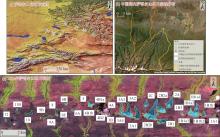
Fig. 1
Location of Saur Mountains and its glacier distribution"

Tab. 1
Landsat image information for glacier boundary interpretation"
| ID | 接收日期(年-月-日) | 传感器 | 分辨率/m | 轨道号 |
|---|---|---|---|---|
| LT41440271989237XXX01 | 1989-08-25 | TM | 30 | 145/027 |
| LT51450271998245BIK00 | 1998-09-02 | TM | 30 | 145/027 |
| LT51450272006251IKR00 | 2006-09-08 | TM | 30 | 145/027 |
| LC81450272016247LGN00 | 2016-09-03 | OLI | 30 | 145/027 |
Tab. 2
Sentinel-2 image information for glacier boundary interpretation in 2022"
| ID | 接收日期(年-月-日) | 传感器 | 解译分辨率/m | 影像用途 |
|---|---|---|---|---|
| S2B_MSIL2A_20220725T051659_N0400_R062_T45TUN_20220725T080907 | 2022-07-25 | MSI | 10 | 主影像 |
| S2A_MSIL2A_20220829T051701_N0400_R062_T45TUN_20220829T095801 | 2022-08-29 | MSI | 10 | 验证补充影像 |
| S2B_MSIL2A_20220824T051649_N0400_R062_T45TUN_20220824T075837 | 2022-08-24 | MSI | 10 | 验证影像 |
| L1C_T45TUN_A027973_20220715T051825 | 2022-07-15 | MSI | 10 | 解译辅影像 |
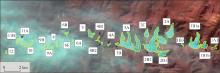
Fig. 2
Distribution of glacier in Saur Mountains in 2016"

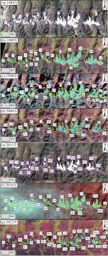
Fig. 3
Distribution and identifiers of glaciers of the Saur Mountains in different periods"

Tab. 3
Basic information on the distribution of glaciers in Saur Mountains in 2022"
| 范围 | 冰川名称 | 经度/°E | 纬度/°N | 面积/km2 | 最低海拔/m | 最高海拔/m | 海拔跨度/m | 平均海拔/m | 中值海拔/m |
|---|---|---|---|---|---|---|---|---|---|
| 中国境内 | 1A1 | 85.66 | 47.06 | 0.11 | 3271 | 3647 | 376 | 3420.90 | 3425 |
| 1B1a1 | 85.63 | 47.06 | 1.09 | 3218 | 3783 | 565 | 3567.41 | 3546 | |
| 1B1a2 | 85.62 | 47.06 | 0.28 | 3248 | 3779 | 531 | 3635.20 | 3697 | |
| 1B1a3 | 85.62 | 47.06 | 0.06 | 3685 | 3766 | 81 | 3739.27 | 3745 | |
| 1B1b1 | 85.65 | 47.06 | 0.27 | 3290 | 3728 | 438 | 3487.64 | 3490 | |
| 1B1b2 | 85.64 | 47.06 | 0.04 | 3576 | 3724 | 148 | 3665.03 | 3671 | |
| 1B3 | 85.61 | 47.06 | 0.10 | 3275 | 3756 | 481 | 3516.53 | 3520 | |
| 2A | 85.59 | 47.07 | 0.92 | 3128 | 3693 | 565 | 3506.20 | 3522 | |
| 2B1 | 85.58 | 47.05 | 0.59 | 3224 | 3780 | 556 | 3497.95 | 3483 | |
| 2B2a | 85.56 | 47.06 | 2.95 | 3166 | 3827 | 661 | 3531.01 | 3544 | |
| 2B2b | 85.55 | 47.06 | 0.08 | 3568 | 3758 | 190 | 3705.46 | 3718 | |
| 2C | 85.55 | 47.07 | 0.35 | 3182 | 3700 | 518 | 3491.95 | 3494 | |
| 哈萨克斯 坦境内 | 3A1 | 85.54 | 47.06 | 0.98 | 3174 | 3712 | 538 | 3418.67 | 3418 |
| 3A2 | 85.52 | 47.06 | 1.20 | 3051 | 3714 | 663 | 3506.64 | 3529 | |
| 3A3 | 85.51 | 47.06 | 0.32 | 3210 | 3646 | 436 | 3515.26 | 3557 | |
| 3A4 | 85.51 | 47.06 | 0.16 | 3421 | 3693 | 272 | 3613.99 | 3638 | |
| 3B | 85.50 | 47.06 | 0.01 | 3426 | 3616 | 190 | 3521.53 | 3512 | |
| 4A | 85.49 | 47.06 | 0.08 | 3178 | 3447 | 269 | 3271.90 | 3266 | |
| 4B1a | 85.47 | 47.06 | 0.11 | 3275 | 3459 | 184 | 3364.50 | 3367 | |
| 4B1b | 85.47 | 47.06 | 0.03 | 3536 | 3639 | 103 | 3591.43 | 3594 | |
| 4B2 | 85.48 | 47.06 | 0.04 | 3518 | 3657 | 139 | 3602.27 | 3610 | |
| 5 | 85.46 | 47.07 | 0.36 | 3206 | 3722 | 516 | 3568.88 | 3632 | |
| 6A | 85.43 | 47.06 | 0.07 | 3251 | 3592 | 341 | 3399.24 | 3390 | |
| 6B | 85.42 | 47.07 | 0.11 | 3347 | 3691 | 344 | 3562.03 | 3587 | |
| 6E | 85.42 | 47.06 | 0.02 | 3464 | 3590 | 126 | 3544.19 | 3556 | |
| 8 | 85.41 | 47.06 | 0.22 | 3252 | 3634 | 382 | 3449.19 | 3440 | |
| 9A | 85.40 | 47.05 | 0.09 | 3273 | 3434 | 161 | 3349.45 | 3352 | |
| 9B | 85.39 | 47.05 | 0.30 | 3211 | 3454 | 243 | 3290.22 | 3287 | |
| 10 | 85.36 | 47.06 | 0.34 | 3163 | 3423 | 260 | 3289.50 | 3295 | |
| 11B | 85.34 | 47.06 | 0.16 | 3329 | 3590 | 261 | 3494.12 | 3518 | |
| 12 | 85.32 | 47.05 | 0.03 | 3228 | 3431 | 203 | 3316.89 | 3310 |
Tab. 4
Evolution of glacier number in Saur Mountains"
| 年份 | 冰川数量/条 | 冰川数量/条 | |
|---|---|---|---|
| 中国境内 | 哈萨克斯坦境内 | ||
| 1984 | 12 | 2 | 10 |
| 1989 | 20 | 5 | 15 |
| 1998 | 27 | 13 | 14 |
| 2006 | 22 | 7 | 15 |
| 2016 | 24 | 8 | 16 |
| 2022 | 31 | 12 | 19 |
Tab. 5
Changes of glacier area in Saur Mountains"
| 年份 | 冰川面积/km2 | 冰川面积/km2 | |
|---|---|---|---|
| 中国境内 | 哈萨克斯坦境内 | ||
| 1989 | 19.58 | 10.35 | 9.23 |
| 1998 | 16.779 | 8.955 | 7.824 |
| 2006 | 14.59 | 8.13 | 6.46 |
| 2016 | 12.89 | 7.22 | 5.67 |
| 2022 | 11.47 | 6.84 | 4.63 |
Tab. 6
Changes of glacier length in Saur Mountains"
| 年份 | 冰川长度/km | 冰川长度/km | |
|---|---|---|---|
| 中国境内 | 哈萨克斯坦境内 | ||
| 1989 | 25.24 | 10.54 | 14.70 |
| 1998 | 23.14 | 9.86 | 13.28 |
| 2006 | 20.93 | 9.55 | 11.38 |
| 2016 | 19.31 | 8.87 | 10.44 |
| 2022 | 17.78 | 8.26 | 9.52 |
Tab. 7
Distribution of glacier area and length in Saur Mountains from 1989 to 2022"
| 范围 | 冰川编号 | 1989年 | 1998年 | 2006年 | 2016年 | 2022年 | ||||||||||||||
|---|---|---|---|---|---|---|---|---|---|---|---|---|---|---|---|---|---|---|---|---|
| 面积/km2 | 长度/km | 面积/km2 | 长度/km | 面积/km2 | 长度/km | 面积/km2 | 长度/km | 面积/km2 | 长度/km | |||||||||||
| 国内 | 1 | 1A | 1A1 | 0.90 | 1.18 | 0.34 | 0.90 | 0.32 | 0.85 | 0.19 | 0.78 | 0.11 | 0.56 | |||||||
| 1A2 | 0.01 | 0.06 | ||||||||||||||||||
| 1A3 | 0.01 | 0.08 | ||||||||||||||||||
| 1A4 | 0.02 | 0.26 | ||||||||||||||||||
| 1A5 | 0.01 | 0.13 | ||||||||||||||||||
| 1B | 1B1 | 1B1a | 1B1a1 | 3.18 | 2.39 | 2.54 | 2.23 | 2.23 | 2.15 | 1.55 | 1.90 | 1.09 | 1.70 | |||||||
| 1B1a2 | 0.28 | 0.80 | ||||||||||||||||||
| 1B1a3 | 0.06 | 0.30 | ||||||||||||||||||
| 1B1b | 1B1b1 | 0.46 | 0.98 | 0.27 | 0.80 | |||||||||||||||
| 1B1b2 | 0.04 | 0.26 | ||||||||||||||||||
| 1B2 | 0.05 | 0.57 | ||||||||||||||||||
| 1B3 | 0.13 | 0.79 | 0.12 | 0.60 | 0.05 | 0.43 | 0.10 | 0.51 | ||||||||||||
| 1B4 | 0.002 | 0.05 | ||||||||||||||||||
| 1B5 | 0.003 | 0.07 | ||||||||||||||||||
| 2 | 2A | 1.12 | 2.09 | 1.09 | 2.07 | 1.05 | 2.04 | 0.88 | 1.77 | 0.92 | 1.80 | |||||||||
| 2B | 2B1 | 4.65 | 3.62 | 4.30 | 3.43 | 0.67 | 1.60 | 0.59 | 1.38 | 0.59 | 1.40 | |||||||||
| 2B2 | 2B2a | 3.34 | 3.32 | 3.13 | 3.20 | 2.95 | 3.10 | |||||||||||||
| 2B2b | 0.08 | 0.45 | ||||||||||||||||||
| 2C | 0.50 | 1.26 | 0.45 | 1.23 | 0.40 | 1.22 | 0.37 | 1.22 | 0.35 | 1.10 | ||||||||||
| 国外 | 3 | 3A | 3A1 | 3.72 | 2.62 | 3.42 | 2.58 | 3.14 | 2.39 | 3.08 | 2.32 | 0.98 | 1.95 | |||||||
| 3A2 | 1.20 | 2.10 | ||||||||||||||||||
| 3A3 | 0.32 | 1.30 | ||||||||||||||||||
| 3A4 | 0.16 | 0.70 | ||||||||||||||||||
| 3B | 0.03 | 0.28 | 0.01 | 0.20 | ||||||||||||||||
| 4 | 4A | 0.54 | 0.88 | 0.38 | 0.87 | 0.11 | 0.55 | 0.04 | 0.41 | 0.08 | 0.50 | |||||||||
| 4B | 4B1 | 4B1a | 0.54 | 1.01 | 0.31 | 0.92 | 0.30 | 0.85 | 0.1 | 0.69 | 0.11 | 0.67 | ||||||||
| 4B1b | 0.03 | 0.26 | ||||||||||||||||||
| 4B2 | 0.12 | 0.43 | 0.09 | 0.34 | 0.08 | 0.29 | 0.04 | 0.27 | ||||||||||||
| 5 | 0.68 | 1.44 | 0.59 | 1.35 | 0.53 | 1.18 | 0.43 | 1.17 | 0.36 | 1.01 | ||||||||||
| 6 | 6A | 0.26 | 0.98 | 0.18 | 0.71 | 0.05 | 0.34 | 0.05 | 0.33 | 0.07 | 0.38 | |||||||||
| 6B | 0.23 | 0.72 | 0.20 | 0.70 | 0.16 | 0.53 | 0.14 | 0.47 | 0.11 | 0.44 | ||||||||||
| 6C | 0.03 | 0.16 | ||||||||||||||||||
| 6D | 0.03 | 0.27 | ||||||||||||||||||
| 6E | 0.08 | 0.42 | 0.04 | 0.27 | 0.03 | 0.14 | 0.02 | 0.12 | 0.02 | 0.12 | ||||||||||
| 7 | 0.01 | 0.11 | 0.004 | 0.06 | ||||||||||||||||
| 8 | 0.38 | 1.23 | 0.33 | 1.16 | 0.29 | 1.09 | 0.25 | 1.05 | 0.22 | 1.02 | ||||||||||
| 9 | 9A | 0.91 | 1.38 | 0.75 | 1.29 | 0.14 | 0.63 | 0.14 | 0.62 | 0.09 | 0.50 | |||||||||
| 9B | 0.44 | 1.22 | 0.44 | 1.20 | 0.30 | 0.98 | ||||||||||||||
| 10 | 1.14 | 1.72 | 0.95 | 1.71 | 0.73 | 1.58 | 0.54 | 1.51 | 0.34 | 1.20 | ||||||||||
| 11 | 11A | 0.46 | 1.11 | 0.38 | 1.08 | 0.04 | 0.42 | 0.04 | 0.39 | |||||||||||
| 11B | 0.27 | 0.94 | 0.25 | 0.85 | 0.16 | 0.80 | ||||||||||||||
| 12 | 0.22 | 0.65 | 0.17 | 0.58 | 0.14 | 0.57 | 0.04 | 0.32 | 0.03 | 0.30 | ||||||||||
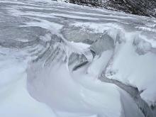
Fig. 4
Expansion of supra-glacial drainage caused by intense melting in Muz Taw Glacier"

Tab. 8
Comparison of glacier changes in 14 mountains in western China"
| 山脉 | 年份 | 面积变化/km2 | 年平均面积变化/km2∙a-1 | 面积变化率/% | 年平均面积变化率/%∙a-1 | 资料来源 |
|---|---|---|---|---|---|---|
| 阿尔泰山 | 1960—2009 | -104.61 | -2.13 | -36.91 | -0.75 | 姚晓军等[ |
| 萨吾尔山 | 1959—2006 | -7.75 | -0.16 | -48.80 | -1.04 | 本研究 |
| 天山 | 1959—2009 | -1619.82 | -32.40 | -18.41 | -0.37 | 邢武成等[ |
| 喀喇昆仑山 | 1978—2015 | -237.55 | -6.42 | -7.77 | -0.21 | 许艾文[ |
| 帕米尔高原 | 1963—2009 | -248.70 | -5.41 | -10.80 | -0.24 | Zhang等[ |
| 昆仑山 | 1970—2010 | -95.06 | -2.38 | -13.60 | -0.34 | Bao等[ |
| 阿尔金山 | 1973—2015 | -58.78 | -1.40 | -16.80 | -0.40 | 胡凡盛等[ |
| 祁连山 | 1956—2010 | -420.81 | -7.79 | -20.88 | -0.39 | Sun等[ |
| 唐古拉山 | 1969—2015 | -524.80 | -11.41 | -24.00 | -0.52 | Duan等[ |
| 羌塘高原 | 1970—2000 | - 90.12 | -3.00 | -4.35 | -0.15 | 王利平等[ |
| 冈底斯山 | 1970—2016 | -854.05 | -18.57 | -39.53 | -0.86 | Liu等[ |
| 喜马拉雅山 | 1990—2015 | -2553.10 | -102.12 | -10.99 | -0.44 | 冀琴等[ |
| 念青唐古拉山 | 1980—2016 | -1000.61 | -27.79 | -10.80 | -0.30 | 邸宝刚[ |
| 横断山 | 1973—2013 | -278.57 | -7.53 | -41.81 | -1.13 | 李霞[ |
| [1] | IPCC. Climate change 2021:The physical science basis. Contribution of working group I to the sixth assessment report of the intergovernmental panel on climate change[M]. Cambridge: Cambridge University Press, 2021. |
| [2] | Bojinski S, Verstraete M, Peterson T C, et al. The concept of essential climate variables in support of climate research, applications, and policy[J]. Bulletin of the American Meteorological Society, 2014, 95(9): 1431-1443. |
| [3] |
牟建新, 李忠勤, 张慧, 等. 全球冰川面积现状及近期变化——基于2017年发布的Randolph冰川编目[J]. 冰川冻土, 2018, 40(2): 238-248.
doi: 10.7522/j.issn.1000-0240.2018.0028 |
|
[Mu Jianxin, Li Zhongqin, Zhang Hui, et al. The global glacierized area: Current situation and recent change, based on the Randolph Glacier Inventory (RGI 6.0) published in 2017[J]. Journal of Glaciology and Geocryology, 2018, 40(2): 238-248.]
doi: 10.7522/j.issn.1000-0240.2018.0028 |
|
| [4] | 马丽娟, 效存德, 康世昌. 全球主要山地气候变化特征和异同——IPCC AR6 WGI报告和SROCC综合解读[J]. 气候变化研究进展, 2022, 18(5): 605-621. |
| [Ma Lijuan, Xiao Cunde, Kang Shichang. Characteristics, and similarities and differences of climate change in major high mountains in the world: Comprehensive interpretation of IPCC AR6 WGI report and SROCC[J]. Advances in Climate Change Research, 2022, 18(5): 605-621.] | |
| [5] | Pritchard H D. Asia’s glaciers are a regionally important buffer against drought[J]. Nature, 2017, 545(7653): 169-174. |
| [6] |
刘时银, 姚晓军, 郭万钦, 等. 基于第二次冰川编目的中国冰川现状[J]. 地理学报, 2015, 70(1): 3-16.
doi: 10.11821/dlxb201501001 |
|
[Liu Shiyin, Yao Xiaojun, Guo Wanqin, et al. The contemporary glaciers in China based on the Second Chinese Glacier Inventory[J]. Acta Geographica Sinica, 2015, 70(1): 3-16.]
doi: 10.11821/dlxb201501001 |
|
| [7] | 王宁练, 姚檀栋, 徐柏青, 等. 全球变暖背景下青藏高原及周边地区冰川变化的时空格局与趋势及影响[J]. 中国科学院院刊, 2019, 34(11): 1220-1232. |
| [Wang Ninglian, Yao Tandong, Xu Baiqing, et al. Spatiotemporal pattern, trend, and influence of glacier change in Tibetan Plateau and surroundings under global warming[J]. Bulletin of Chinese Academy of Sciences, 2019, 34(11): 1220-1232.] | |
| [8] | 王宗太. 中国各山脉的冰川最新统计及其分布特征[J]. 干旱区地理, 1988, 11(3): 8-14. |
| [Wang Zongtei. New statistical figures and distribution feature of glaciers on the various mountains in China[J]. Arid Land Geography, 1988, 11(3): 8-14.] | |
| [9] | Shi Y F, Liu S Y, Ye B S, et al. Concise glacier inventory of China[M]. Shanghai: Shanghai Popular Science Press, 2008. |
| [10] |
怀保娟, 李忠勤, 王飞腾, 等. 1959—2013年中国境内萨吾尔山冰川变化特征[J]. 冰川冻土, 2015, 37(5): 1141-1149.
doi: 10.7522/j.isnn.1000-0240.2015.0128 |
|
[Huai Baojuan, Li Zhongqin, Wang Feiteng, et al. Variation of glaciers in the Sawuer Mountain within Chinese territory during 1959—2013[J]. Journal of Glaciology and Geocryology, 2015, 37(5): 1141-1149.]
doi: 10.7522/j.isnn.1000-0240.2015.0128 |
|
| [11] | Bai C B, Wang F T, Bi Y Q, et al. Increased mass loss of glaciers in the Sawir Mountains of Central Asia between 1959 and 2021[J]. Remote Sensing, 2022, 14(21): 5406, doi: 10.3390/rs14215406. |
| [12] |
王炎强, 赵军, 李忠勤, 等. 1977—2017年萨吾尔山冰川变化及其对气候变化的响应[J]. 自然资源学报, 2019, 34(4): 802-814.
doi: 10.31497/zrzyxb.20190410 |
|
[Wang Yanqiang, Zhao Jun, Li Zhongqin, et al. Glacier changes in the Sawuer Mountain during 1977—2017 and their response to climate change[J]. Journal of Natural Resources, 2019, 34(4): 802-814.]
doi: 10.31497/zrzyxb.20190410 |
|
| [13] | 尹立东. 萨吾尔山地植被概况[J]. 植物生态学与地植物学学报, 1986, 10(4): 316-322. |
| [Yin Lidong. Vegetation of the Sawur Mountain[J]. Chinese Journal of Plant Ecology, 1986, 10(4): 316-322.] | |
| [14] | Le Bris R, Paul F, Frey H, et al. A new satellite-derived glacier inventory for western Alaska[J]. Annals of Glaciology, 2011, 52(59): 135-143. |
| [15] | Bolch T, Menounos B, Wheate R. Landsat-based inventory of glaciers in western Canada, 1985—2005[J]. Remote Sensing of Environment, 2010, 114(1): 127-137. |
| [16] | Winsvold S H, Andreassen L M, Kienholz C. Glacier area and length changes in Norway from repeat inventories[J]. The Cryosphere, 2014, 8(5): 1885-1903. |
| [17] | Paul F, Rastner P, Azzoni R S, et al. Glacier shrinkage in the Alps continues unabated as revealed by a new glacier inventory from Sentinel-2[J]. Earth System Science Data, 2020, 12(3): 1805-1821. |
| [18] |
张慧, 李忠勤, 牟建新, 等. 近50年新疆天山奎屯河流域冰川变化及其对水资源的影响[J]. 地理科学, 2017, 37(11): 1771-1777.
doi: 10.13249/j.cnki.sgs.2017.11.020 |
|
[Zhang Hui, Li Zhongqin, Mu Jianxin, et al. Impact of the glacier change on water resources in the Kuytun River Basin, Tianshan Mountains during recent 50 years[J]. Scientia Geographica Sinica, 2017, 37(11): 1771-1777.]
doi: 10.13249/j.cnki.sgs.2017.11.020 |
|
| [19] |
姚晓军, 刘时银, 朱钰, 等. 基于GIS的冰川中流线自动提取方法设计与实现[J]. 冰川冻土, 2015, 37(6): 1563-1570.
doi: 10.7522/j.issn.1000-0240.2015.0173 |
|
[Yao Xiaojun, Liu Shiyin, Zhu Yu, et al. Design and implementation of an automatic method for deriving glacier centerlines based on GIS[J]. Journal of Glaciology and Geocryology, 2015, 37(6): 1563-1570.]
doi: 10.7522/j.issn.1000-0240.2015.0173 |
|
| [20] | 中国气象局国家气候中心. 中国气候变化蓝皮书(2023)[M]. 北京: 科学出版社, 2023. |
| [National Climate Centre of China Meteorological Administration. Blue book on climate change in China (2023)[M]. Beijing: Science Press, 2023.] | |
| [21] | 李忠勤. 山地冰川物质平衡和动力过程模拟[M]. 北京: 科学出版社, 2019. |
| [Li Zhongqin. Mass balance and dynamic process simulation of mountain glaciers[M]. Beijing: Science Press, 2019.] | |
| [22] | Wang P Y, Li H L, Li Z Q, et al. Cryosphere changes and their impacts on regional water resources in the Chinese Altai Mountains from 2000 to 2021[J]. Catena, 2024, 235: 107644, doi: 10.1016/j.catena.2023.107644. |
| [23] | Jouberton A, Shaw T E, Miles E, et al. Warming-induced monsoon precipitation phase change intensifies glacier mass loss in the southeastern Tibetan Plateau[J]. Proceedings of the National Academy of Sciences, 2022, 119(37): e2109796119, doi: 10.1073/pans.2109796119. |
| [24] | Zhang Y L, Gao T G, Kang S C, et al. Albedo reduction as an important driver for glacier melting in Tibetan Plateau and its surrounding areas[J]. Earth-Science Reviews, 2021, 220: 103735, doi: 10.1016/j.earscirev.2021.103735. |
| [25] |
毛瑞娟, 蒋熹, 郭忠明, 等. 基于TM/ETM+影像反演祁连山七一冰川反照率精度比较研究[J]. 冰川冻土, 2013, 35(2): 301-309.
doi: 10.7522/j.issn.1000-0240.2013.0036 |
| [Mao Ranjuan, Jiang Xi, Guo Zhongming, et al. Study of the inversion precision of albedo on the Qiyi Glacier in the Qilian Mountain based on TM/ETM+ image[J]. Journal of Glaciology and Geocryology, 2013, 35(2): 301-309.] | |
| [26] | Yue X Y, Li Z Q, Wang F T, et al. Spatiotemporal variations in surface albedo during the ablation season and linkages with the annual mass balance on Muz Taw Glacier, Altai Mountains[J]. International Journal of Digital Earth, 2022, 15(1): 2126-2147. |
| [27] | Xu C H, Li Z Q, Mu J X, et al. High-precision measurements of the inter-annual evolution for Urumqi Glacier No.1 in eastern Tien Shan, China[J]. Sciences in Cold and Arid Regions, 2022, 13(6): 474-487. |
| [28] | 刘时银, 张勇, 刘巧, 等. 气候变化影响与风险: 气候变化对冰川影响与风险研究[M]. 北京: 科学出版社, 2017. |
| [Liu Shiyin, Zhang Yong, Liu Qiao, et al. Climate change impact and risk: Impact and risk of climate change on glacier[M]. Beijing: Science Press, 2017.] | |
| [29] |
姚晓军, 刘时银, 郭万钦, 等. 近50 a来中国阿尔泰山冰川变化——基于中国第二次冰川编目成果[J]. 自然资源学报, 2012, 27(10): 1734-1745.
doi: 10.11849/zrzyxb.2012.10.011 |
|
[Yao Xiaojun, Liu Shiyin, Guo Wanqin, et al. Glacier change of Altay Mountain in China from 1960 to 2009: Based on the second glacier inventory of China[J]. Journal of Natural Resources, 2012, 27(10): 1734-1745.]
doi: 10.11849/zrzyxb.2012.10.011 |
|
| [30] |
邢武成, 李忠勤, 张慧, 等. 1959年来中国天山冰川资源时空变化[J]. 地理学报, 2017, 72(9): 1594-1605.
doi: 10.11821/dlxb201709005 |
|
[Xing Wucheng, Li Zhongqin, Zhang Hui, et al. Spatial-temporal variation of glacier resources in Chinese Tianshan Mountains since 1959[J]. Acta Geographica Sinica, 2017, 72(9): 1594-1605.]
doi: 10.11821/dlxb201709005 |
|
| [31] | 许艾文. 近40年中国喀喇昆仑山冰川变化的遥感监测[D]. 兰州: 兰州大学, 2017. |
| [Xu Aiwen. Monitoring glacier change based on remote sensing in China Karakoram for the last four decades[D]. Lanzhou: Lanzhou University, 2017.] | |
| [32] | Zhang Z, Xu J L, Liu S Y, et al. Glacier changes since the early 1960s, eastern Pamir, China[J]. Journal of Mountain Science, 2016, 13(2): 276-291. |
| [33] | Bao W J, Liu S Y, Wei J F, et al. Glacier changes during the past 40 years in the west Kunlun Shan[J]. Journal of Mountain Science, 2015, 12(2): 344-357. |
| [34] | 胡凡盛, 杨太保, 冀琴, 等. 近40 a阿尔金山冰川与气候变化关系研究[J]. 干旱区地理, 2017, 40(3): 581-588. |
| [Hu Fansheng, Yang Taibao, Ji Qin, et al. Relationship between the glacier and climate change in the Altun Mountain in recent four decades[J]. Arid Land Geography, 2017, 40(3): 581-588.] | |
| [35] |
Sun M P, Liu S Y, Yao X J, et al. Glacier changes in the Qilian Mountains in the past half-century: Based on the revised First and Second Chinese Glacier Inventory[J]. Journal of Geographical Sciences, 2018, 28: 206-220.
doi: 10.1007/s11442-018-1468-y |
| [36] | Duan H Y, Yao X J, Liu S Y, et al. Glacier change in the Tanggula Mountains, Tibetan Plateau, in 1969—2015[J]. Journal of Mountain Science, 2019, 16(11): 2663-2678. |
| [37] | 王利平, 谢自楚, 刘时银, 等. 1970—2000年羌塘高原冰川变化及其预测研究[J]. 冰川冻土, 2011, 33(5): 979-990. |
| [Wang Liping, Xie Zichu, Liu Shiyin, et al. Glacierized area variation and its response to climate change in Qangtang Plateau during 1970—2000[J]. Journal of Glaciology and Geocryology, 2011, 33(5): 979-990.] | |
| [38] |
Liu J, Yao X J, Liu S Y, et al. Glacial changes in the Gangdisê Mountains from 1970 to 2016[J]. Journal of Geographical Sciences, 2020, 30: 131-144.
doi: 10.1007/s11442-020-1719-6 |
| [39] |
冀琴, 刘睿, 杨太保. 1990—2015年喜马拉雅山冰川变化的遥感监测[J]. 地理研究, 2020, 39(10): 2403-2414.
doi: 10.11821/dlyj020190283 |
| [Ji Qin, Liu Rui, Yang Taibao. Glacier variations in the Himalayas during 1990—2015[J]. Geographical Research, 2020, 39(10): 2403-2414.] | |
| [40] | 邸宝刚. 念青唐古拉山脉36年来冰川变化及其对气候变化的响应[D]. 北京: 中国地质大学(北京), 2019. |
| [Di Baogang. Glacier change in the Nianqing Tanggula Mountains in 36 years and its response to climate change[D]. Beijing: University of Geosciences (Beijing), 2019.] | |
| [41] | 李霞. 近40年横断山冰川变化的遥感监测研究[D]. 兰州: 兰州大学, 2015. |
| [Li Xia. Monitoring glacier change based on remote sensing in the Hengduan Mountains for the last four decades[D]. Lanzhou: Lanzhou University, 2015.] |
| [1] | HU Fan-sheng, YANG Tai-bao, JI Qin, WANG Cong-qiang, XU Ai-wen. Relationship between the glacier and climate change in the Altun Mountain in recent four decades [J]. , 2017, 40(3): 581-588. |
| [2] | MENG Yan-cong, LI Zhong-qin, XU Chun-hai, HUAI Bao-juan. Glacier change ofWestern China since the Little Ice Age: a case of the Urumqi River Watershed [J]. , 2016, 39(3): 486-494. |
|
||