- Apr. 11, 2025
Arid Land Geography ›› 2021, Vol. 44 ›› Issue (2): 460-470.doi: 10.12118/j.issn.1000–6060.2021.02.17
• Earth Information Sciences • Previous Articles Next Articles
LI Haoxin1( ),WAN Huawei2,SUN Lin1,LIU Yuping2(),LI Liping3,WANG Yongcai2
Received:2020-11-10
Revised:2021-02-07
Online:2021-03-25
Published:2021-04-14
Contact:
Yuping LIU
E-mail:1197665475@qq.com;lyping3349@sina.com
LI Haoxin,WAN Huawei,SUN Lin,LIU Yuping,LI Liping,WANG Yongcai. Remote sensing assessment and key driving factors of ecosystem health in Xinjiang[J].Arid Land Geography, 2021, 44(2): 460-470.

Fig. 1
Classification of land cover in Xinjiang"

Tab. 1
Data source and basic information"
| 基础数据 | 数据来源 | 空间分辨率 | 合成方式 | 时间 |
|---|---|---|---|---|
| 归一化植被指数 | MOD13 A2产品 | 1 km | 16 d合成 | 2000、2010、2018年6—9月 |
| 地表温度 | MOD11 A2产品 | 1 km | 8 d合成 | 2000、2010、2018年6—9月 |
| 土地覆盖类型 | 2000、2010、2018年全国30 m分辨率土地覆盖分类数据 | 30 km | 最邻近内插法合成 | 2000、2010、2018年6—9月 |
| 动物物种丰富度 | 文献资料查询 | 10 km | 统计合成 | 2010年 |
Tab. 2
Data source and basic information"
| 指标 | 方差膨胀因子(VIF) | 容忍度(TOL) |
|---|---|---|
| 归一化植被指数 | 1.918 | 0.521 |
| 动物物种丰富度 | 1.242 | 0.805 |
| 人类扰动指数 | 1.521 | 0.657 |
| 干旱度 | 1.269 | 0.788 |
Tab. 3
Equivalent conversion coefficients of different types of land cover in Xinjiang"
| 土地利用/覆被类型 | CI值 | 土地利用/覆被类型 | CI值 |
|---|---|---|---|
| 耕地 | 0.200 | 低覆盖改良草地 | 0.067 |
| 水田 | 0.200 | 水库池塘 | 0.600 |
| 旱地 | 0.200 | 城镇用地 | 1.000 |
| 高覆盖改良草地 | 0.067 | 农村居民点 | 1.000 |
| 中覆盖改良草地 | 0.067 | 建设用地 | 1.000 |
Tab. 4
Indicator system of remote sensing assessment of ecological health in Xinjiang"
| 目标层 | 准则层 | 指标层 | 属性 |
|---|---|---|---|
| 新疆生态健康(EH) | 活力(EV) | 归一化植被指数(NDVI) | 正向 |
| 组织力(EO) | 动物物种丰富度(ASR) | 正向 | |
| 恢复力(ER) | 人类扰动指数(HDI) | 负向 | |
| 干旱度(DI) | 负向 |
Tab. 5
The type of interaction between independent factors and dependent variables"
| 判据 | 交互作用 |
|---|---|
                 | 非线性减弱 |
  | 单因子非线性减弱 |
 | 双因子增强 |
 | 独立 |
| 非线性增强 |
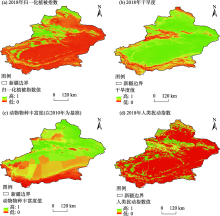
Fig. 2
Spatial distribution of single factor index"

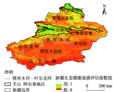
Fig. 3
Ecological quality evaluation index of Xinjiang in 2018"

Tab. 6
Single factor detection and analysis results"
| 单因子指标 | 影响力(q) | 解释力(p) | 影响力排序 |
|---|---|---|---|
| 归一化植被指数 | 0.645 | 0.00 | 1 |
| 动物物种丰富度 | 0.414 | 0.00 | 3 |
| 人类扰动指数 | 0.512 | 0.00 | 2 |
| 干旱度 | 0.116 | 0.00 | 4 |
Tab. 7
Interaction probe analysis results"
| 交互指标 | 交互关系 |
|---|---|
| NDVI | 双因子增强 |
| NDVI | 双因子增强 |
| NDVI | 双因子增强 |
| 人类扰动指数 | 双因子增强 |
| 人类扰动指数 | 双因子增强 |
| 干旱度 | 非线性增强 |

Fig. 4
Classification of remote sensing assessment of ecological health in counties in different year"

Tab. 8
Mean value of single factor index and ecological health assessment index from 2000 to 2018"
| 年份 | 归一化植被指数 | 动物物种丰富度 | 干旱度 | 人类扰动指数 | 生态健康评估指数 |
|---|---|---|---|---|---|
| 2000 | 0.20 | 0.55 | 0.64 | 0.25 | 0.027 |
| 2010 | 0.34 | 0.55 | 0.63 | 0.28 | 0.035 |
| 2018 | 0.32 | 0.55 | 0.60 | 0.26 | 0.037 |
| [1] | Chiu G S, Guttorp P, Westveld A H, et al. Latent health factor index: A statistical modeling approach for ecological health assessment[J]. Environmetrics, 2011,22(3):243-255. |
| [2] | Armah F A, Luginaah I, Essandoh P K, et al. Ecological health status of the Fosu Lagoon Southern Ghana I: Biotic assessment[J]. Journal of Ecosystem & Ecography, 2012,2(1):433-441. |
| [3] | Patil G P, Myers Wayne L. Environmental and ecological health assessment of landscapes and watersheds with remote sensing data[J]. Ecosyst Health, 1999,4(5):221-224. |
| [4] | Sheldon F. Incorporating natural variability into the assessment of ecological health in Australian dryland rivers[J]. Hydro Biologia, 2005,552(1):45-56. |
| [5] | 徐菲, 王永刚, 张楠, 等. 北京市白河和潮河流域生态健康评价[J]. 生态学报, 2017,37(3):932-942. |
| [ Xu Fei, Wang Yonggang, Zhang Nan, et al. Health assessment of watershed ecosystems[J]. Chinese Journal of Ecology, 2017,37(3):932-942. ] | |
| [6] | James R K, Kurt D F, Paul L A, et al. Assessing biological integrity in running waters: A method and its rationale[J]. Special Publication, 1986,12(5):312-319. |
| [7] | 杨斌, 隋鹏, 陈源泉, 等. 生态系统健康评价研究进展[J]. 中国农学通报, 2010,26(21):291-296. |
| [ Yang Bin, Sui Peng, Chen Yuanquan, et al. Progress in ecosystem health assessment[J]. Chinese Agricultural Science Bulletin, 2010,26(21):291-296. ] | |
| [8] | 黄和平, 杨劼, 毕军. 生态系统健康研究综述与展望[J]. 环境污染与防治, 2006,28(10):768-771. |
| [ Huang Heping, Yang Jie, Bi Jun. Review on ecosystem health research[J]. Environmental Pollution & Control, 2006,28(10):768-771. ] | |
| [9] | 谭娟, 王卿, 沙晨燕, 等. 基于指标体系法的生态系统健康评价[J]. 中国人口资源与环境, 2012,22(增刊1):352-355. |
| [ Tan Juan, Wang Qing, Sha Chenyan, et al. Studies on ecosystem health assessment based on index system method[J]. China Population, Resources and Environment, 2012,22(Suppl. 1):352-355. ] | |
| [10] | Benjamin S H, Catherine L, Darren H, et al. An index to assess the health and benefits of the global ocean[J]. Nature, 2012,488(3):615-620. |
| [11] | Langat D K, Maranga E K, Aboud A A, et al. Role of forest resources to local livelihoods: The case of east Mau forest ecosystem, Kenya[J]. International Journal of Forestry Research, 2016,216:1-10. |
| [12] | 王立新, 刘钟龄, 刘华民, 等. 内蒙古典型草原生态系统健康评价[J]. 生态学报, 2008,28(2):544-550. |
| [ Wang Lixin, Liu Zhongling, Liu Huamin, et al. Assessment of typical steppe ecosystem health in Inner Mongolia[J]. Chinese Journal of Ecology, 2008,28(2):544-550. ] | |
| [13] | HJ/T 192-2006. 生态环境状况评价技术规范(试行)[S]. 北京: 中国环境科学出版社出版发行, 2006. |
| [ HJ/T 192-2006. Technical specification for eco-environmental assessment (trial)[S]. Beijing: China Environmental Science Press, 2006. ] | |
| [14] | 徐涵秋. 城市遥感生态指数的创建及其应用[J]. 生态学报, 2012,33(24):7853-7862. |
| [ Xu Hanqiu. A remote sensing urban ecological index and its application[J]. Acta Ecologica Sinica, 2012,33(24):7853-7862. ] | |
| [15] | 周雪欣, 罗昊. 基于GIS与RS技术的北盘江流域生态环境质量评价研究[J]. 环境科学与管理, 2018,248(7):182-186. |
| [ Zhou Xuexin, Luo Hao. Ecological environment quality evaluation of Beipanjiang River Basin based on GIS and RS technology[J]. Environmental Science and Management, 2018,248(7):182-186. ] | |
| [16] | 刘索玄, 袁艳斌, 赵皞, 等. 基于遥感生态指数(RSEI)的水电开发区生态环境变化分析: 以清江中下游地区为例[J]. 生态与农村环境学报, 2019,35(11):1361-1368. |
| [ Liu Suoxuan, Yuan Yanbin, Zhao Hao, et al. Analysis of ecological environment changes in hydropower development zone based on RSEI: A case study in the middle and lower reaches of the Qingjiang River, China[J]. Journal of Ecology and Rural Environment, 2019,35(11):1361-1368. ] | |
| [17] | 宋媛, 石惠春, 谢敏慧, 等. 2000—2017年甘肃省生态环境质量时空演变格局及其影响因素[J]. 生态学杂志, 2019,38(12):3800-3808. |
| [ Song Yuan, Shi Huichun, Xie Minhui, et al. Spatiotemporal evolution pattern and influencing factors of eco-environmental quality in Gansu from 2000 to 2017[J]. Chinese Journal of Ecology, 2019,38(12):3800-3808. ] | |
| [18] | 邓力琛, 刘寿东, 赵小艳. 基于MOD13A2数据的长三角区域土地覆盖类型变化研究[J]. 中国科技论文, 2015,10(15):1822-1827. |
| [ Deng Lishen, Liu Shoudong, Zhao Xiaoyan. Study on the change in land cover of Yangtze River Delta based on MOD13A2 data[J]. China Science Paper, 2015,10(15):1822-1827. ] | |
| [19] | Zhou G Q, Kang C L, Wang Y F, et al. Characteristics of urban heat island distribution in Guangxi Beibu Gulf Economic Zone based on MOD11A2[C]// International Conference on Intelligent Earth Observing & Applications. International Society for Optics and Photonics, 2015: 814-980. |
| [20] | 夏列钢, 骆剑承, 王卫红, 等. 遥感信息图谱支持的土地覆盖自动分类[J]. 遥感学报, 2014,18(4):788-803. |
| [ Xia Liegang, Luo Jiancheng, Wang Weihong, et al. Land cover automatic classification based on RS-Informatic Tupu[J]. Journal of Remote Sensing, 2014,18(4):788-803. ] | |
| [21] | 马鸣. 新疆鸟类名录[M]. 北京: 科学出版社, 2002: 41-62. |
| [ Ma Ming. Xinjiang bird list[M]. Beijing: Science Press, 2002: 41-62. ] | |
| [22] | 阿布力米提. 新疆哺乳类(兽纲)名录[M]. 北京: 科学出版社, 2002: 10-33. |
| [ Abulimiti. Catalogue of mammals (animal class) in Xinjiang[M]. Beijing: Science Press, 2002: 10-33. ] | |
| [23] | 李利平, 尹林克, 唐志尧. 新疆野生动植物物种丰富度的分布格局[J]. 干旱区研究, 2011,28(1):1-9. |
| [ Li Liping, Yin Linke, Tang Zhirao. Distribution patterns of the species richness of plants and animals in Xinjiang, China[J]. Arid Zone Research. 2011,28(1):1-9. ] | |
| [24] | Lu F, Li Z. A model of ecosystem health and its application[J]. Ecological Modelling, 2003,170(1):55-59. |
| [25] |
Pantus F, Dennidon W. Quantifying and evaluating ecosystem health: A case study from Moreton Bay, Australia[J]. Environmental Management, 2005,36(5):757-771.
doi: 10.1007/s00267-003-0110-6 pmid: 16206027 |
| [26] | 欧阳晓, 朱翔, 贺清云. 基于生态系统服务和生态系统健康的生态风险评价: 以长株潭城市群为例[J]. 生态学报, 2020,40(16):5478-5489. |
| [ Ouyang Xiao, Zhu Xiang, He Qingyun. Incorporating ecosystem services with ecosystem health for ecological risk assessment: Case study in Changsha, Zhuzhou and Xiangtan urban agglomeration, China[J]. Chinese Journal of Ecology, 2020,40(16):5478-5489. ] | |
| [27] | Samuel N, Goward, Czajkowski K P, et al. Evaluating land surface moisture conditions from the remotely sensed temperature/vegetation index measurements: An exploration with the simplified simple biosphere model[J]. Remote Sensing of Environment, 2002,79(2/3):225-242. |
| [28] | Peng J, Liu Y, Li T, et al. Regional ecosystem health response to rural land use change: A case study in Lijiang City, China[J]. Ecological Indicators, 2017,72:399-410. |
| [29] | 倪永明. 新疆荒漠生态系统评价及其综合治理模式[D]. 北京: 中国科学院生态环境研究中心, 2005. |
| [ Ni Yongming. Evaluation of desert ecosystem in Xinjiang and its comprehensive management model[D]. Beijing: Research Center for Eco-Environmental Sciences, Chinese Academy of Sciences, 2005. ] | |
| [30] | 黄莹, 包安明, 刘海隆, 等. 基于景观格局的新疆生态脆弱性综合评价研究[J]. 干旱地区农业研究, 2009,27(3):261-266. |
| [ Huang Ying, Bao Anming, Liu Hailong, et al. Analysis of ecological vulnerability in Xinjiang based on its landscape pattern[J]. Agricultural Research in the Arid Areas, 2009,27(3):261-266. ] | |
| [31] | 黄明, 张学霞, 张建军, 等. 基于CLUE-S模型的罗玉沟流域多尺度土地利用变化模拟[J]. 资源科学, 2012,34(4):769-776. |
| [ Huang Ming, Zhang Xuexia, Zhang Jianjun, et al. A multi-scale simulation of land use change in Luoyugou Watershed based on CLUE-S model[J]. Resources Science, 2012,34(4):769-776. ] | |
| [32] | 何宝忠, 丁建丽, 李焕, 等. 新疆植被物候时空变化特征[J]. 生态学报, 2018,38(6):2139-2155. |
| [ He Baozhong, Ding Jianli, Li Huan, et al. Spatiotemporal variation of vegetation phenology in Xinjiang from 2001 to 2016[J]. Acta Ecologica Sinica, 2018,38(6):2139-2155. ] | |
| [33] | 尼加提·伊米尔, 满苏尔·沙比提, 玉苏甫·买买提. 天山北坡植被NDVI时空变化及其与气候因子的关系[J]. 干旱区研究, 2019,36(5):205-215. |
| [ Nijiati Yimier, Mansuer Shabiti, Yusupu Maimaiti. Spatiotemporal variation of vegetation NDVI and its relationship with climatic factors on the northern slope of the Tianshan Mountains[J]. Arid Zone Research, 2019,36(5):205-215. ] | |
| [34] | 杨怡, 吴世新, 庄庆威, 等. 2000—2018年古尔班通古特沙漠EVI时空变化特征[J]. 干旱区研究, 2019,36(6):191-199. |
| [ Yang Yi, Wu Shixin, Zhuang Qingwei, et al. Spatiotemporal change of EVI in the Gurbantunggut Desert from 2000 to 2018[J]. Arid Zone Research, 2019,36(6):191-199. ] | |
| [35] | 李海霞, 杨井, 陈亚宁, 等. 基于MODIS数据的新疆地区土壤湿度反演[J]. 草业学报, 2017,26(6):16-27. |
| [ Li Haixia, Yang Jing, Chen Yaning, et al. Retrieval of soil moisture information in Xinjiang using MODIS[J]. Acta Prataculturae Sinica, 2017,26(6):16-27. ] | |
| [36] | 陈丙寅, 杨辽, 陈曦, 等. 基于改进型TVDI在干旱区旱情监测中的应用研究[J]. 干旱区地理, 2019,42(4):902-913. |
| [ Chen Bingyin, Yang Liao, Chen Xi, et al. Application of modified TVDI in drought monitoring in arid areas[J]. Arid Land Geography, 2019,42(4):902-913. ] | |
| [37] | 高瑜莲, 柳锦宝, 柳维扬, 等. 近14 a新疆南疆绿洲地区地表蒸散与干旱的时空变化特征研究[J]. 干旱区地理, 2019,42(4):830-837. |
| [ Gao Yulian, Liu Jinbao, Liu Weiyang, et al. Spatio-temporal variation characteristics of surface evapotranspiration and drought at the oasis area of the southern Xinjiang in recent 14 years[J]. Arid Land Geography, 2019,42(4):830-837. ] | |
| [38] | 徐勇, 孙晓一, 汤青. 陆地表层人类活动强度: 概念、方法及应用[J]. 地理学报, 2015,70(7):46-57. |
| [ Xu Yong, Sun Xiaoyi, Tang Qing. Human activity intensity of land surface: Concept, method and application in China[J]. Acta Geographica Sinica, 2015,70(7):46-57. ] | |
| [49] | 王劲峰, 徐成东. 地理探测器:原理与展望[J]. 地理学报, 2017,72(1):116-134. |
| [ Wang Jinfeng, Xu Chengdong. Geodetector: Principle and prospective[J]. Acta Geographica Sinica, 2017,72(1):116-134. ] | |
| [40] | 郭泽呈, 魏伟, 庞素菲, 等. 基于SPCA和遥感指数的干旱内陆河流域生态脆弱性时空演变[J]. 生态学报, 2019,39(7):296-310. |
| [ Guo Zecheng, Wei Wei, Pang Sufei, et al. Spatiotemporal evolution pattern and influencing factors of eco-environmental quality in Gansu from 2000 to 2017[J]. Chinese Journal of Ecology, 2019,39(7):296-310. ] | |
| [41] | 佚名. 2017年中国生态环境状况公报[R]. 北京: 生态环境部, 2018. |
| [ Anonymity. The state of China’s ecological environment in 2017[R]. Beijing: Ministry of Ecology and Environment of the People’s Repoblic of China, 2018. ] | |
| [42] | 周紫燕, 汪小钦. 新疆生态质量变化趋势遥感分析[J]. 生态学报, 2019,40(9):1-13. |
| [ Zhou Ziyan, Wang Xiaoqin. Remote sensing analysis of ecological quality change in Xinjiang[J]. Chinese Journal of Ecology, 2019,40(9):1-13. ] | |
| [43] | 韩鑫, 王玥, 刘传胜, 等. 新疆天山自然遗产地景观格局动态演化及其生态健康评价[J]. 干旱区地理, 2019,42(1):195-205. |
| [ Han Xin, Wang Yue, Liu Chuansheng, et al. Dynamic evolution of landscape pattern and ecological health assessment of Tianshan Natural Heritage Site in Xinjiang[J]. Arid Land Geography, 2019,42(1):195-205. ] |
| [1] | LI Jianhui, CHEN Lin, DANG Zheng. Spatial pattern and influencing factors of patriotic education bases in the Yellow River Basin [J]. Arid Land Geography, 2023, 46(9): 1536-1544. |
| [2] | MA Zhenbang,WANG Sijian,LI Wei,LYU Peng,GUO Xiaodong. Poverty evolution and its implications in the Liupan Mountain Area of Gansu Province from 1986 to 2020 [J]. Arid Land Geography, 2023, 46(9): 1545-1555. |
| [3] | ZHANG Hao, HAN Zenglin, QIAO Guorong, WANG Hui, WANG Hongye, DUAN Ye. Patterns and influencing factors of tourism economic linkages between cities in the Yellow River Basin [J]. Arid Land Geography, 2023, 46(8): 1344-1354. |
| [4] | BAI Yang,HU Jingxuan,CHEN Chunyan,LU Wen. Regional differences and influencing factors of efficiency of tourism aid for Xinjiang: Based on three-stage DEA and Tobit model [J]. Arid Land Geography, 2023, 46(8): 1366-1375. |
| [5] | KANG Ligang, CAO Shengkui, CAO Guangchao, YAN Li, CHEN Lianxuan, LI Wenbin, ZHAO Haoran. Spatiotemporal variation of land surface temperature in Qinghai Lake Basin [J]. Arid Land Geography, 2023, 46(7): 1084-1097. |
| [6] | XIA Wenhao, WANG Mingyang, JIANG Lei. Spatiotemporal variation trends and convergence analysis of agricultural carbon emission intensity in Xinjiang [J]. Arid Land Geography, 2023, 46(7): 1145-1154. |
| [7] | YAO Lanbo, YE Jianming, WANG Yun, ZHU Xianwei. Spatiotemporal evolution and mechanism of coupling coordination of human settlements system in arid area: A case of Xinjiang [J]. Arid Land Geography, 2023, 46(6): 1013-1023. |
| [8] | YANG Rui, LI Jianyong, WANG Ninglian, CHEN Xiaojun, DU Jianfeng, LIU Jianbo, HAN Yueting. Holocene sediment element geochemical records and their paleoenvironmental significance in Wenquan area of western Tianshan Mountains [J]. Arid Land Geography, 2023, 46(6): 900-910. |
| [9] | ZHANG Lieqin, LU Yi’nong, LONG Zhen, LI Qinglei, WANG Tao. Spatial distribution pattern of cultural tourism in Xinjiang [J]. Arid Land Geography, 2023, 46(5): 823-833. |
| [10] | ZHU Lei, LI Yannan, HU Jing, TIAN Xiaobo, XU Jiahui, QING Qi. Multi-scale characteristics and influencing mechanism of spatial pattern on research and practice bases in China [J]. Arid Land Geography, 2023, 46(4): 625-635. |
| [11] | YAN Xinjie, SUN Hui, XIN Long. Spatial distribution and location choice of resource-based enterprises in Xinjiang [J]. Arid Land Geography, 2023, 46(4): 678-687. |
| [12] | ZHANG Ning,WANG Zichen,YANG Xiao,CHEN Tong,XING Fei. Coupling coordination and spatiotemporal differences between water resources and agriculture cropping system in Xinjiang: A case of grain and cotton cropping systems [J]. Arid Land Geography, 2023, 46(3): 349-359. |
| [13] | CHENG Jing,WANG Peng,CHEN Hongxiang,HAN Yonggui. Spatiotemporal evolution of habitat quality in the Weihe River Basin and its topographic gradient effects and influencing factors [J]. Arid Land Geography, 2023, 46(3): 481-491. |
| [14] | MA Li’na, ZHANG Feiyun, ZHAI Yuxin, TENG Lun, KANG Jianguo. Temporal and spatial evolution of ecosystem service value under land use change in Xinjiang from 1980 to 2020 [J]. Arid Land Geography, 2023, 46(2): 253-263. |
| [15] | LU Chenyu,HUANG Ping,ZHANG Tong,LIU Xiaowan,CHENG Wei. Spatiotemporal evolution and driving factors of the green development efficiency in Gansu Province [J]. Arid Land Geography, 2023, 46(2): 305-315. |
| Viewed | ||||||||||||||||||||||||||||||||||||||||||||||||||
|
Full text 119
|
|
|||||||||||||||||||||||||||||||||||||||||||||||||
|
Abstract 432
|
|
|||||||||||||||||||||||||||||||||||||||||||||||||
Cited |
|
|||||||||||||||||||||||||||||||||||||||||||||||||
| Shared | ||||||||||||||||||||||||||||||||||||||||||||||||||
|
||