Arid Land Geography ›› 2022, Vol. 45 ›› Issue (4): 1176-1185.doi: 10.12118/j.issn.1000-6060.2021.531
• Earth Information Sciences • Previous Articles Next Articles
DAI Yunhao1( ),GUAN Yao1,ZHANG Qinkai1,SUN Junjie1,HE Xinghong1,2()
Received:2021-11-10
Revised:2022-01-09
Online:2022-07-25
Published:2022-08-11
Contact:
Xinghong HE
E-mail:917473073@qq.com;hexinghong0611@163.com
DAI Yunhao,GUAN Yao,ZHANG Qinkai,SUN Junjie,HE Xinghong. Remote sensing monitoring and temporal and spatial characteristics of soil salinization in Aral Reclamation Area[J].Arid Land Geography, 2022, 45(4): 1176-1185.
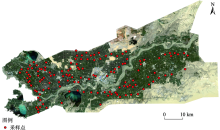
Fig. 1
Overview and distribution of sampling points in Aral Reclamation Area"
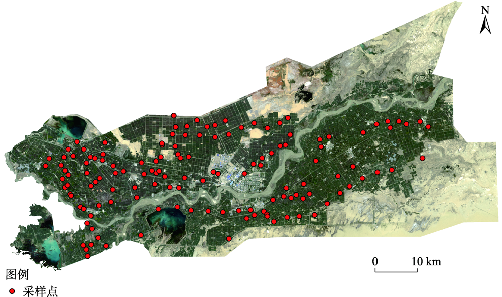

Fig. 2
Extraction of water bodies and unvegetated sandy land"

Fig. 3
SI-NDVI scatter diagram"

Tab. 1
Fitting of two-dimensional scatter model"
| 模型 | 公式 | 拟合度R2 |
|---|---|---|
| 线性模型 | y=0.2863-0.2832x | 0.8677 |
| 二次模型 | y=0.3163-0.4948x+0.2251x2 | 0.8867 |
| 指数模型 | y=0.3488×0.1816x-0.0239 | 0.8881 |
| 几何模型 | y=-0.3565x0.4846+0.3842 | 0.8877 |
| 双曲模型 | y=1.0/(2.5226+12.022x) | 0.8609 |
| 对数平方模型 | y=0.0334-0.3386logx-0.1013logx2 | 0.8886 |

Fig. 4
Verification of measured conductivity value and SDI model accuracy"

Tab. 2
Classification of soil salinization grade"
| 指标 | 非盐渍土 | 轻度盐渍土 | 中度盐渍土 | 重度盐渍土 | 盐土 |
|---|---|---|---|---|---|
| 土壤电导率/mS·cm-1 | 0~2 | 2~4 | 4~8 | 8~16 | >16 |
| SDI模型 | 0.000~0.3119 | 0.3119~0.3877 | 0.3877~0.5393 | 0.5393~0.8425 | >0.8425 |

Fig. 5
Distribution of soil salinization in Aral Reclamation Area"

Tab. 3
Statistics of soil salinization area in Aral Reclamation Area from 2011 to 2021 /km2"
| 年份 | 非盐渍土 | 轻度盐渍土 | 中度盐渍土 | 重度盐渍土 | 盐土 |
|---|---|---|---|---|---|
| 2011 | 972.98 | 251.09 | 405.55 | 872.51 | 810.60 |
| 2021 | 1291.20 | 251.89 | 328.71 | 719.48 | 879.21 |
Tab. 4
Transfer matrix of soil salinization area in Aral Reclamation Area from 2011 to 2021 /km2"
| 土壤盐渍化等级 | 2011年 | |||||
|---|---|---|---|---|---|---|
| 非盐渍土 | 轻度盐渍土 | 中度盐渍土 | 重度盐渍土 | 盐土 | ||
| 2021年 | 非盐渍土 | 758.50 | 107.67 | 155.89 | 183.29 | 51.11 |
| 轻度盐渍土 | 87.83 | 39.14 | 60.40 | 51.07 | 8.65 | |
| 中度盐渍土 | 58.94 | 40.45 | 99.71 | 105.19 | 15.31 | |
| 重度盐渍土 | 43.58 | 20.56 | 70.42 | 392.91 | 140.02 | |
| 盐土 | 19.10 | 3.35 | 7.12 | 94.15 | 506.45 | |

Fig. 6
Dynamic changes of soil salinization in Aral Reclamation Area from 2011 to 2021"

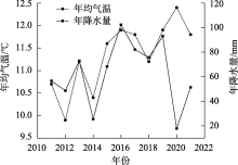
Fig. 7
Average annual temperature and annual precipitation in Aral Reclamation Area in recent 10 years"
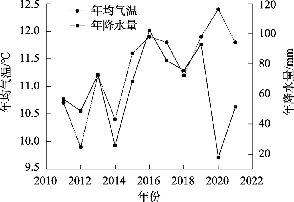
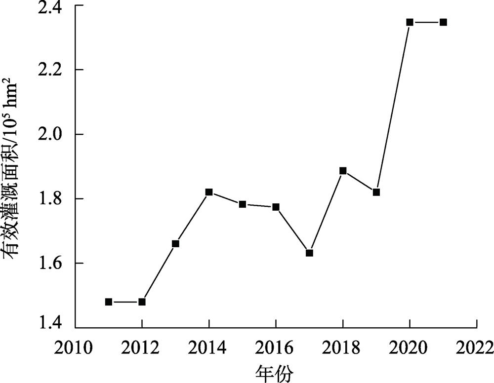
Fig. 8
Effective irrigation area of Aral Reclamation Area in recent 10 years"
| [1] |
姜红, 玉素甫江·如素力, 热伊莱·卡得尔, 等. 基于神经网络模型的干旱区绿洲土壤盐渍化评价分析[J]. 地球信息科学学报, 2017, 19(7): 983-993.
doi: 10.3724/SP.J.1047.2017.00983 |
|
[ Jiang Hong, Rusuli Yusufujiang, Kadeer Reyilai, et al. Evaluation and analysis of soil salinization in the arid zones based on neural network model[J]. Journal of Geo-Information Science, 2017, 19(7): 983-993. ]
doi: 10.3724/SP.J.1047.2017.00983 |
|
| [2] |
Yu T, Jiapaer G, Bao A, et al. Using synthetic remote sensing indicators to monitor the land degradation in a salinized area[J]. Remote Sensing, 2021, 13(15): 2851, doi: 10.3390/rs13152851.
doi: 10.3390/rs13152851 |
| [3] | 曹肖奕, 丁建丽, 葛翔宇, 等. 基于不同卫星光谱模拟的土壤电导率估算研究[J]. 干旱区地理, 2020, 43(1): 172-181. |
| [ Cao Xiaoyi, Ding Jianli, Ge Xiangyu, et al. Estimation of soil conductivity based on spectral simulation of different satellites[J]. Arid Land Geography, 2020, 43(1): 172-181. ] | |
| [4] | 冯娟, 丁建丽, 杨爱霞, 等. 干旱区土壤盐渍化信息遥感建模[J]. 干旱地区农业研究, 2018, 36(1): 266-273. |
| [ Feng Juan, Ding Jianli, Yang Aixia, et al. Remote sensing modeling of soil salinization information in arid areas[J]. Agricultural Research in the Arid Areas, 2018, 36(1): 266-273. ] | |
| [5] |
Mohamed E S, Saleh A M, Belal A B, et al. Application of near-infrared reflectance for quantitative assessment of soil properties[J]. The Egyptian Journal of Remote Sensing and Space Science, 2018, 21(1): 1-14.
doi: 10.1016/j.ejrs.2017.02.001 |
| [6] | 贾萍萍, 尚天浩, 张俊华, 等. 利用多源光谱信息反演宁夏银北地区干湿季土壤含盐量[J]. 农业工程学报, 2020, 36(17): 125-134. |
| [ Jia Pingping, Shang Tianhao, Zhang Junhua, et al. Inversion of soil salinity in dry and wet seasons based on multi-source spectral data in Yinbei area of Ningxia, China[J]. Transactions of the Chinese Society of Agricultural Engineering, 2020, 36(17): 125-134. ] | |
| [7] | 张素铭, 赵庚星, 王卓然, 等. 滨海盐渍区土壤盐分遥感反演及动态监测[J]. 农业资源与环境学报, 2018, 35(4): 349-358. |
| [ Zhang Suming, Zhao Gengxing, Wang Zhuoran, et al. Remote sensing inversion and dynamic monitoring of soil salt in coastal saline area[J]. Journal of Agricultural Resources and Environment, 2018, 35(4): 349-358. ] | |
| [8] |
Dwivedi R S, Rao B R M. The selection of the best possible landsat TM band combination for delineating salt-affected soils[J]. International Journal of Remote Sensing, 1992, 13(11): 2051-2058.
doi: 10.1080/01431169208904252 |
| [9] |
Sidike A, Zhao S, Wen Y. Estimating soil salinity in Pingluo County of China using QuickBird data and soil reflectance spectra[J]. International Journal of Applied Earth Observation and Geoinformation, 2014, 26: 156-175.
doi: 10.1016/j.jag.2013.06.002 |
| [10] | El-Horiny M M. Mapping and monitoring of soil salinization using remote sensing and regression techniques: A case study in the Bahariya depression, Western Desert, Egypt[C]//IGARSS 2019-2019 IEEE International Geoscience and Remote Sensing Symposium. Yokohama: IEEE, 2019: 1-4. |
| [11] | 孙亚楠, 李仙岳, 史海滨, 等. 基于多源数据融合的盐分遥感反演与季节差异性研究[J]. 农业机械学报, 2020, 51(6): 169-180. |
| [ Sun Ya’nan, Li Xianyue, Shi Haibin, et al. Remote sensing inversion of soil salinity and seasonal difference analysis based on multi-source data fusion[J]. Transactions of the Chinese Society for Agricultural Machinery, 2020, 51(6): 169-180. ] | |
| [12] | 黄权中, 徐旭, 吕玲娇, 等. 基于遥感反演河套灌区土壤盐分分布及对作物生长的影响[J]. 农业工程学报, 2018, 34(1): 102-109. |
| [ Huang Quanzhong, Lü Lingjiao, et al. Soil salinity distribution based on remote sensing and its effect on crop growth in Hetao irrigation district[J]. Transactions of the Chinese Society of Agricultural Engineering, 2018, 34(1): 102-109. ] | |
| [13] | 陈红艳, 赵庚星, 陈敬春, 等. 基于改进植被指数的黄河口区盐渍土盐分遥感反演[J]. 农业工程学报, 2015, 31(5): 107-114. |
| [ Chen Hongyan, Zhao Gengxing, Chen Jingchun, et al. Remote sensing inversion of saline soil salinity based on modified vegetation index in estuary area of Yellow River[J]. Transactions of the Chinese Society of Agricultural Engineering, 2015, 31(5): 107-114. ] | |
| [14] | 刘恩, 王军涛, 常步辉, 等. 小开河引黄灌区土壤盐渍化定量遥感反演[J]. 中国农村水利水电, 2019(12): 20-24. |
| [ Liu En, Wang Juntao, Chang Buhui, et al. Quantitative remote sensing inversion of soil salinization in Xiaokaihe Yellow River irrigation district[J]. China Rural Water and Hydropower, 2019(12): 20-24. ] | |
| [15] | 边玲玲, 王卷乐, 郭兵, 等. 基于特征空间的黄河三角洲垦利县土壤盐分遥感提取[J]. 遥感技术与应用, 2020, 35(1): 211-218. |
| [ Bian Lingling, Wang Juanle, Guo Bing, et al. Remote sensing extraction of soil salinity in Yellow River delta Kenli County based on feature space[J]. Remote Sensing Technology and Application, 2020, 35(1): 211-218. ] | |
| [16] | 丁建丽, 瞿娟, 孙永猛, 等. 基于MSAVI-WI特征空间的新疆渭干河-库车河流域绿洲土壤盐渍化研究[J]. 地理研究, 2013, 32(2): 223-232. |
| [ Ding Jianli, Qu Juan, Sun Yongmeng, et al. The retrieval model of soil salinization information in arid region based on MSAVI-WI feature space case study of the delta oasis in Weigan-Kuqa watershed[J]. Geographical Research, 2013, 32(2): 223-232. ] | |
| [17] |
陈实, 高超, 徐斌, 等. 新疆石河子农区土壤含盐量定量反演及其空间格局分析[J]. 地理研究, 2014, 33(11): 2135-2144.
doi: 10.11821/dlyj201411013 |
|
[ Chen Shi, Gao Chao, Xu Bin, et al. Quantitative inversion of soil salinity and analysis of its spatial pattern in agricultural area in Shihezi of Xinjiang[J]. Geographical Research, 2014, 33(11): 2135-2144. ]
doi: 10.11821/dlyj201411013 |
|
| [18] | 王爽, 丁建丽, 王璐, 等. 基于地表光谱建模的区域土壤盐渍化遥感监测研究[J]. 干旱区地理, 2016, 39(1): 190-198. |
| [ Wang Shuang, Ding Jianli, Wang Lu, et al. Remote sensing monitoring of soil salinization based on surface spectral modeling[J]. Arid Land Geography, 2016, 39(1): 190-198. ] | |
| [19] | 王丹丹, 于志同, 程猛, 等. 渭干河绿洲不同土地利用类型土壤盐分的变化特征分析[J]. 干旱区地理, 2018, 41(2): 349-357. |
| [ Wang Dandan, Yu Zhitong, Cheng Meng, et al. Characteristics of soil salinity under different land use types in Weigan River Oasis[J]. Arid Land Geography, 2018, 41(2): 349-357. ] | |
| [20] | 麦麦提吐尔逊·艾则孜. 绿洲土壤盐渍化及水盐调控[M]. 北京: 北京理工大学出版社, 2016. |
| [ Azezi Maimaitituerxun. Assessment and monitoring of soil salinization using remote sensing in arid area[M]. Beijing: Beijing Institute of Technology Press, 2016. ] | |
| [21] | 张添佑, 王玲, 曾攀丽, 等. 基于MSAVI-SI特征空间的玛纳斯河流域灌区土壤盐渍化研究[J]. 干旱区研究, 2016, 33(3): 499-505. |
| [ Zhang Tianyou, Wang Ling, Zeng Panli, et al. Soil salinization in the irrigated area of the Manas River Basin based on MSAVI-SI feature space[J]. Arid Zone Research, 2016, 33(3): 499-505. ] | |
| [22] |
Liu J, Zhang L, Dong T, et al. The applicability of remote sensing models of soil salinization based on feature space[J]. Sustainability, 2021, 13(24): 13711, doi: 10.3390/su132413711.
doi: 10.3390/su132413711 |
| [23] | 王飞, 丁建丽, 魏阳, 等. 基于 Landsat 系列数据的盐分指数和植被指数对土壤盐度变异性的响应分析--以新疆天山南北典型绿洲为例[J]. 生态学报, 2017, 37(15): 5007-5022. |
| [ Wang Fei, Ding Jianli, Wei Yang, et al. Sensitivity analysis of soil salinity and vegetation indices to detect soil salinity variation by using Landsat series images: Applications in different oases in Xinjiang, China[J]. Acta Ecologica Sinica, 2017, 37(15): 5007-5022. ] | |
| [24] | 卢晶, 张绪教, 叶培盛, 等. 基于 SI-MSAVI 特征空间的河套灌区盐碱化遥感监测研究[J]. 国土资源遥感, 2020, 32(1): 169-175. |
| [ Lu Jing, Zhang Xujiao, Ye Peisheng, et al. Remote sensing monitoring of salinization in Hetao irrigation district based on SI-MSAVI feature space[J]. Remote Sensing for Land & Resources, 2020, 32(1): 169-175. ] | |
| [25] | 王飞, 丁建丽, 伍漫春. 基于NDVI-SI特征空间的土壤盐渍化遥感模型[J]. 农业工程学报, 2010, 26(8): 168-173. |
| [ Wang Fei, Ding Jianli, Wu Manchun. Remote sensing monitoring models of soil salinization based in NDVI-SI feature space[J]. Transactions of the Chinese Society of Agricultural Engineering, 2010, 26(8): 168-173. ] | |
| [26] | 史晓艳, 李维弟, 余露, 等. 玛纳斯河流域农灌区土壤盐渍化遥感定量评价[J]. 灌溉排水学报, 2018, 37(11): 69-75, 83. |
| [ Shi Xiaoyan, Li Weidi, Yu Lu, et al. Using remote sensing to evaluate soil salinization distribution over the irrigation areas in the Manas River Basin[J]. Journal of Irrigation and Drainage, 2018, 37(11): 69-75, 83. ] | |
| [27] | 王雪梅, 周晓红. 渭干河-库车河三角洲绿洲棉田土壤盐分估算及遥感反演[J]. 干旱地区农业研究, 2018, 36(6): 250-254, 262. |
| [ Wang Xuemei, Zhou Xiaohong. Estimation and inversion modeling of salinity of cotton field soil using remote sensing in the Delta Oasis of Weigan and Kuqa Rivers[J]. Agricultural Research in the Arid Areas, 2018, 36(6): 250-254, 262. ] | |
| [28] | 杨小虎, 罗艳琴, 杨海昌, 等. 玛纳斯河流域绿洲农田土壤盐分反演及空间分布特征[J]. 干旱区资源与环境, 2021, 35(2): 156-161. |
| [ Yang Xiaohu, Luo Yanqin, Yang Haichang, et al. Soil salinity retrieval and spatial distribution of oasis farmland in Manasi River Basin[J]. Journal of Arid Land Resources and Environment, 2021, 35(2): 156-161. ] | |
| [29] | 吴家林. 阿拉尔垦区棉田土壤盐渍化的遥感监测与植棉效益分析[D]. 阿拉尔: 塔里木大学, 2021. |
| [ Wu Jialin. Remote sensing monitoring and cotton plantation benefit analysis of cotton field soil salinization in Aral Reclamation Area[D]. Aral: Tarim University, 2021. ] | |
| [30] | 宋奇, 冯春晖, 高琪, 等. 阿拉尔垦区近30年耕地变化及其驱动因子分析[J]. 国土资源遥感, 2021, 33(2): 202-212. |
| [ Song Qi, Feng Chunhui, Gao Qi, et al. Change of cultivated land and its driving factors in Alar Reclamation Area in the past thirty years[J]. Remote Sensing for Land & Resources, 2021, 33(2): 202-212. ] | |
| [31] | 新疆生产建设兵团年鉴编辑委员会. 兵团年鉴[M]. 乌鲁木齐: 新疆生产建设兵团年鉴社, 2020. |
| [Editorial Committee of Xinjiang Production and Construction Corps Yearbook. Production and Construction Corps yearbook[M]. Urumqi: Xinjiang Production and Construction Corps Yearbook Society, 2020. ] | |
| [32] | 卢晶. 基于3S技术的土壤盐碱化时空分布规律及影响因素研究[D]. 北京: 中国地质大学, 2019. |
| [ Lu Jing. Study on temporal-spatial distribution and impact factors of soil salinization based on 3S technology[D]. Beijing: China University of Geosciences, 2019. ] | |
| [33] |
陈实, 徐斌, 金云翔, 等. 北疆农区土壤盐渍化遥感监测及其时空特征分析[J]. 地理科学, 2015, 35(12): 1607-1615.
doi: 10.13249/j.cnki.sgs.2015.012.1607 |
|
[ Chen Shi, Xu Bin, Jin Yunxiang, et al. Remote sensing monitoring and spatial-temporal characteristics analysis of soil salinization in agricultural area of northern Xinjiang[J]. Scientia Geographica Sinica, 2015, 35(12): 1607-1615. ]
doi: 10.13249/j.cnki.sgs.2015.012.1607 |
|
| [34] | Khan N M, Sato Y. Monitoring hydro-salinity status and its impact in irrigated semi-arid areas using IRS-1B LISS-II data[J]. Asian Journal of Geoinform, 2001, 1(3): 63-73. |
| [35] | 李艳菊, 丁建丽, 米热古力·艾尼瓦尔. 渭-库绿洲土壤剖面盐分分布特征及驱动因子分析[J]. 灌溉排水学报, 2019, 38(6): 58-65. |
| [ Li Yanju, Ding Jianli, Ainiwaer Mireguli. Soil salt distribution and the factors affect it in Ogan Kucha River Oasis[J]. Journal of Irrigation and Drainage, 2019, 38(6): 58-65. ] | |
| [36] | 王遵亲, 祝寿泉, 尤文瑞, 等. 中国盐渍土[M]. 北京: 科学出版社, 1993. |
| [ Wang Zunqin, Zhu Shouquan, You Wenrui, et al. Saline soil in China[M]. Beijing: Science Press, 1993. ] | |
| [37] | Staff U S S L. Diagnosis and improvement of saline and alkali soils[J]. Agriculture Handbook, 1954, 60: 83-100. |
| [38] | 王旭, 田长彦, 赵振勇, 等. 滴灌条件下盐地碱蓬 (Suaeda salsa) 种植年限对盐碱地土壤盐分离子分布的影响[J]. 干旱区地理, 2020, 43(1): 211-217. |
| [ Wang Xu, Tian Changyan, Zhao Zhenyong, et al. Effects of different planting years of Suaeda salsa on the soil ions distribution in saline-sodic soil under drip irrigation[J]. Arid Land Geography, 2020, 43(1): 211-217. ] | |
| [39] | 王世明, 范敬龙, 赵英, 等. 咸水灌溉条件下塔里木河下游沙漠土壤水盐运移数值模拟[J]. 干旱区地理, 2021, 44(4): 1104-1113. |
| [ Wang Shiming, Fan Jinglong, Zhao Ying, et al. Numerical simulation of water and salt migration in desert soil in the lower reaches of Tarim River under salt-water irrigation[J]. Arid Land Geography, 2021, 44(4): 1104-1113. ] |
| [1] | MENG Huimin, ZHAN Chesheng, HU Shi, LIN Zhonghui. Research progress on simulation of soil water-salt transport in large-scale irrigation districts [J]. Arid Land Geography, 2024, 47(9): 1566-1576. |
| [2] | XIE Junbo, WANG Xingpeng, HE Shuai, LIU Yang, ZHONG Zhibo, LI Yan, HONG Guojun. Soil salinity inversion in the Shajingzi irrigation district based on spectral index modeling [J]. Arid Land Geography, 2024, 47(7): 1199-1209. |
| [3] | SHI Cong, CHEN Lihan, ZHANG Yifei, HE Shuai, XIE Haixia. Soil salinization characteristics of cultivated land in Xiaohaizi Irrigation Area of Xinjiang [J]. Arid Land Geography, 2023, 46(8): 1314-1323. |
| [4] | LI Ke, DING Jianli, HAN Lijing, GE Xiangyu, GU Yongsheng, ZHOU Qian, LYU Yangxia. Digital mapping of soil salinization in a typical oasis based on PlanetScope images [J]. Arid Land Geography, 2023, 46(8): 1291-1302. |
| [5] | JIANG Lei, LIU Xiaolong, GUO Shuai, HE Liang, XING Jianlei, GUO Junjie. Evaluation of soil salinization susceptibility based on Logistic regression analysis: A case of Tarim irrigation area in southern Xinjiang [J]. Arid Land Geography, 2023, 46(11): 1858-1867. |
| [6] | ZHAO Qiaozhen,DING Jianli,HAN Lijing,JIN Xiaoye,HAO Jianping. Exploring the application of MODIS and Landsat spatiotemporal fusion images in soil salinization: A case of Ugan River-Kuqa River Delta Oasis [J]. Arid Land Geography, 2022, 45(4): 1155-1164. |
| [7] | WANG Shuang, DING Jian-li, WANG lu, NIU Zeng-yi. Remote sensing monitoring of soil salinization based on surface spectral modeling [J]. , 2016, 39(1): 190-198. |
| [8] | NIU Zeng-yi, DING Jian-li, LI Yan-hua, WANG Shuang, WANG Lu, MA Cheng-xia. Soil salinization information extraction method based on GF-1 image [J]. , 2016, 39(1): 171-181. |
| [9] | WANG Zhong-yuan,WANG Yu-gang,XIE Jiang-bo,LI Yan. Differentiating the soil inorganic CO2 flux of saline and alkaline soils [J]. , 2013, 36(4): 655-661. |
|
||