- Apr. 4, 2025
Arid Land Geography ›› 2024, Vol. 47 ›› Issue (2): 203-213.doi: 10.12118/j.issn.1000-6060.2023.124
• Climatology and Hydrology • Previous Articles Next Articles
WANG Shuzhi1( ), WEN Deping2()
Received:2023-03-21
Revised:2023-08-01
Online:2024-02-25
Published:2024-03-14
Contact:
WEN Deping
E-mail:qhswjcb@163.com;wendeping5@163.com
WANG Shuzhi, WEN Deping. Attribution analysis of runoff change in the Datong River Basin, Qinghai-Tibet Plateau[J].Arid Land Geography, 2024, 47(2): 203-213.

Fig. 1
Distribution of water system and stations in the Datong River Basin"

Tab. 1
Trend test of elements in the Datong River Basin"
| 水文气象 要素 | 变化 趋势 | 线性趋势回归检验 | Kendall秩次检验 | Spearman秩次检验 | |||||
|---|---|---|---|---|---|---|---|---|---|
| T | 显著性水平 (ɑ=0.05,tɑ/2=2.0) | U | 显著性水平 (ɑ=0.05,Uɑ/2=1.96) | T | 显著性水平 (ɑ=0.05,tɑ/2=2.0) | ||||
| 年平均气温 | 增加 | 16.30 | 趋势显著 | 7.74 | 趋势显著 | 16.70 | 趋势显著 | ||
| 年降水量 | 增加 | 2.58 | 趋势显著 | 2.22 | 趋势显著 | 2.25 | 趋势显著 | ||
| 潜在蒸发量 | 增加 | 1.83 | 趋势不显著 | 1.08 | 趋势不显著 | 1.14 | 趋势不显著 | ||
| 年径流量 | 减少 | 1.72 | 趋势不显著 | 1.53 | 趋势不显著 | 1.51 | 趋势不显著 | ||
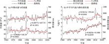
Fig. 2
Sequence change trend of each element"

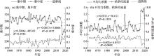
Fig. 3
Interannual variation of runoff indicators at Xiangtang Station"
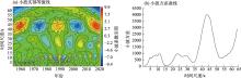
Fig. 4
Period analysis of runoff wavelet"

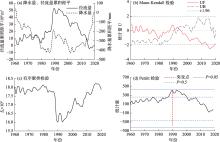
Fig. 5
Abrupt change of annual runoff in the Datong River Basin"

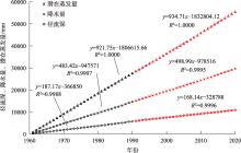
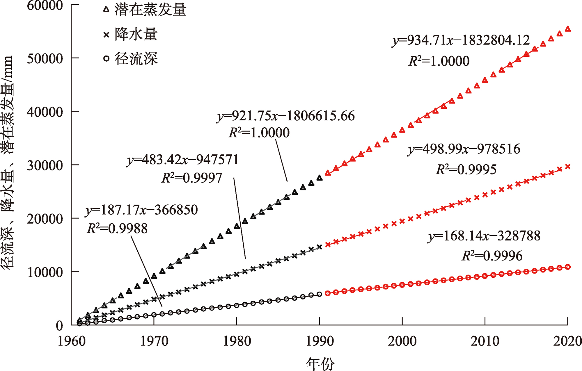
Fig. 6
Fitting relationship between cumulative annual runoff depth, precipitation, evapotranspiration and year in the Datong River Basin"
Tab. 2
Impacts of climate change and human activities on runoff in the Datong River Basin"
| 时期 | 径流深 | 气候变化 | 人类活动 | ||||||||
|---|---|---|---|---|---|---|---|---|---|---|---|
| 斜率 | 变化率/% | 降水量 | 潜在蒸发量 | ||||||||
| 斜率 | 变化率/% | CP/% | 斜率 | 变化率/% | CET/% | CH/% | |||||
| 基准期(1961—1990年) | 187.2 | - | 483.4 | - | - | 921.8 | - | - | - | ||
| 变化期(1991—2020年) | 168.1 | -10.2 | 499.0 | 3.2 | -31.4 | 934.7 | 1.4 | 13.7 | 117.7 | ||
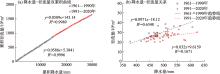
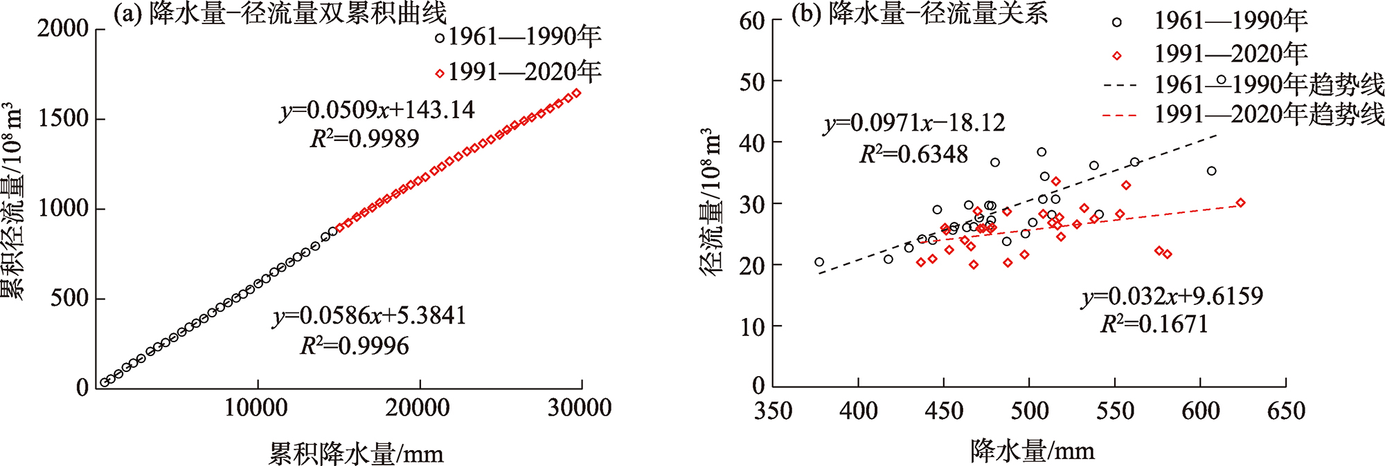
Fig. 7
Double-mass curve and relationship of precipitation-runoff in the Datong River Basin"
Tab. 3
Statistics of glacier area and fractional vegetation cover (FVC) in the Datong River Basin"
| 指标 | 1986年 | 1990年 | 1995年 | 2000年 | 2005年 | 2010年 | 2015年 | 2017年 | 2018年 | 2019年 |
|---|---|---|---|---|---|---|---|---|---|---|
| 冰川面积/km2 | 37.0 | 29.5 | 25.0 | 22.3 | 21.3 | 29.5 | 16.3 | 16.3 | 16.4 | 17.3 |
| FVC年值 | 0.597 | 0.556 | 0.621 | 0.519 | 0.476 | 0.536 | 0.661 | 0.543 | 0.570 | 0.595 |
| FVC生长季均值 | 0.723 | 0.744 | 0.762 | 0.688 | 0.688 | 0.699 | 0.827 | 0.727 | 0.727 | 0.726 |
| 年径流深/mm | 191.3 | 196.3 | 171.3 | 158.4 | 189.5 | 143.0 | 131.9 | 193.0 | 175.3 | 198.8 |
| 生长季径流深/mm | 114.7 | 97.6 | 73.0 | 71.1 | 83.2 | 73.9 | 69.4 | 64.3 | 56.9 | 72.5 |
Fig. 8
Accumulation of installed capacity of hydropower stations and distribution of monthly runoff in different years"
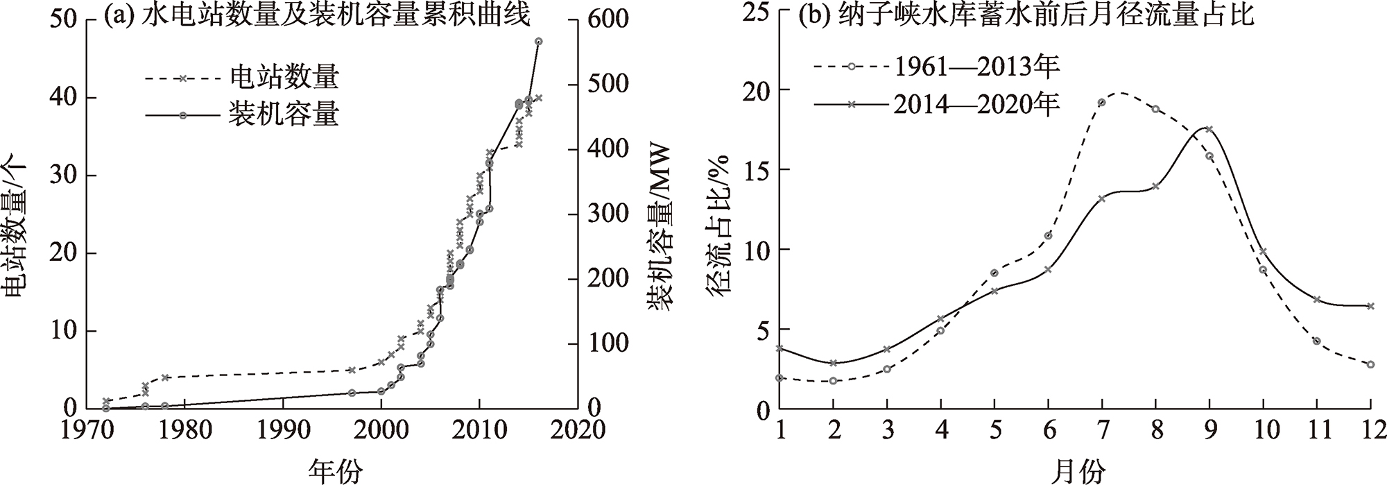
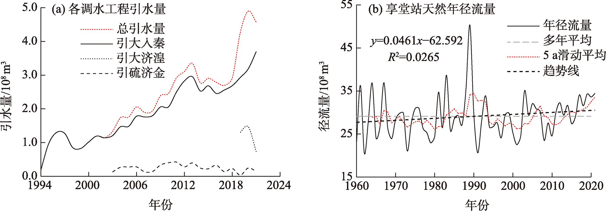
Fig. 9
Diversion of water diversion project and natural annual runoff hydrograph of Xiangtang Station"
| [1] | 张建云, 王国庆. 河川径流变化及归因定量识别[M]. 北京: 科学出版社, 2014. |
| [ Zhang Jianyun, Wang Guoqing. Quantitative identification of river runoff change and attribution[M]. Beijing: Science Press, 2014. ] | |
| [2] | 杜嘉妮, 蔡宜晴, 刘希胜, 等. 基于Budyko假设的湟水径流变化归因识别[J]. 中国农村水利水电, 2022(7): 116-121. |
| [ Du Jiani, Cai Yiqing, Liu Xisheng, et al. Attribution analysis of runoff in the Huangshui River based on the Budyko hypothesis[J]. China Rural Water and Hydropower, 2022(7): 116-121. ] | |
| [3] | 吴恒卿, 刘赛艳, 黄强, 等. 基于SWAT模型的大通河流域径流模拟[J]. 西北农林科技大学学报(自然科学版), 2015, 43(9): 210-216. |
| [ Wu Hengqing, Liu Saiyan, Huang Qiang, et al. SWAT model based runoff simulation of Datong River Basin[J]. Journal of Northwest A & F University (Natural Science Edition), 2015, 43(9): 210-216. ] | |
| [4] | 白雁翎, 王芳, 刘扬. 大通河上游径流演变及驱动因素定量分析[J]. 南水北调与水利科技, 2021, 19(1): 103-110, 167. |
| [ Bai Yanling, Wang Fang, Liu Yang. Quantitative analysis of runoff evolution and driving factors in the upper reaches of Datong River[J]. South-to-North Water Transfers and Water Science & Technology, 2021, 19(1): 103-110, 167. ] | |
| [5] | 王大超. 大通河径流变化特征及其影响因素探析[D]. 兰州: 兰州大学, 2019. |
| [ Wang Dachao. Runoff variation characteristics for Datong River and its influencing factors[D]. Lanzhou: Lanzhou University, 2019. ] | |
| [6] | 张成凤, 刘翠善, 王国庆, 等. 基于Budyko假设的黄河源区径流变化归因识别[J]. 中国农村水利水电, 2020(9): 90-94. |
| [ Zhang Chengfeng, Liu Cuishan, Wang Guoqing, et al. Attribution of runoff variation for the Yellow River source region based on the Budyko hypothesis[J]. China Rural Water and Hydropower, 2020(9): 90-94. ] | |
| [7] |
王随继, 闫云霞, 颜明, 等. 皇甫川流域降水和人类活动对径流量变化的贡献率分析——累积量斜率变化率比较方法的提出及应用[J]. 地理学报, 2012, 67(3): 388-397.
doi: 10.11821/xb201203010 |
|
[ Wang Suiji, Yan Yunxia, Yan Ming, et al. Contributions of precipitation and human activities to the runoff change of the Huangfuchuan Drainage Basin: Application of comparative method of the slope changing ratio of cumulative quantity[J]. Acta Geographica Sinica, 2012, 67(3): 388-397. ]
doi: 10.11821/xb201203010 |
|
| [8] | 郭爱军, 畅建霞, 黄强, 等. 渭河流域气候变化与人类活动对径流影响的定量分析[J]. 西北农林科技大学学报(自然科学版), 2014, 42(8): 212-220. |
| [ Guo Aijun, Chang Jianxia, Huang Qiang, et al. Quantitative analysis of the impacts of climate change and human activities on runoff change in Weihe Basin[J]. Journal of Northwest A & F University (Natural Science Edition), 2014, 42(8): 212-220. ] | |
| [9] | 李佳, 汪赢政, 李建江. 祁连山地区冰川边界产品(1980—2015)[DB]. 国家青藏高原科学数据中心, https://doi.org/10.11888/Geogra.tpdc.270234. |
| [ Li Jia, Wang Yingzheng, Li Jianjiang. Glacier outlines over the Qilian Mountain area (1980—2015)[DB]. National Tibetan Plateau/Third Pole Environment Data Center, https://doi.org/10.11888/Geogra.tpdc.270234. ] | |
| [10] | 仲波, 吴俊君. 祁连山区域基于Landsat 反射率数据的月度30 m×30 m地表植被指数数据(1986—2017)[DB]. 国家青藏高原科学数据中心, https://doi.org/10.1188/Geogra.tpdc.270136. |
| [ Zhong Bo, Wu Junjun. Landsat-based continuous monthly 30 m×30 m land surface NDVI dataset in Qilian Mountain area (1986—2017)[DB]. National Tibetan Plateau/Third Pole Environment Data Center, https://doi.org/10.1188/Geogra.tpdc.270136. ] | |
| [11] | GB/T20481-2017. 中华人民共和国国家标准: 气象干旱等级[S]. 北京: 中国标准出版社, 2017. |
| GB/T20481-2017. National Standard of the People’s Republic of China: Grades of meteorological drought[S]. Beijing: Standard Press of China, 2017. ] | |
| [12] | 魏凤英. 现代气候统计诊断与预测技术[M]. 北京: 气象出版社, 2007. |
| [ Wei Fengying. Modern technology of statistics, diagnosis and forecast for climate[M]. Beijing: China Meteorological Press, 2007. ] | |
| [13] | 黄强, 黄生志, 潘晶晶. 水文序列变异诊断理论与方法[M]. 北京: 科学出版社, 2020. |
| [ Huang Qiang, Huang Shengzhi, Pan Jingjing. Theory and methods of hydrological sequence variation diagnosis[M]. Beijing: Science Press, 2020. ] | |
| [14] | 成艺, 武兰珍, 刘峰贵, 等. 黄河上游近60 a径流量与降水量变化特征研究[J]. 干旱区地理, 2022, 45(4): 1022-1031. |
| [ Cheng Yi, Wu Lanzhen, Liu Fenggui, et al. Changes of runoff and precipitation in the upstream of Yellow River during the past 60 years[J]. Arid Land Geography, 2022, 45(4): 1022-1031. ] | |
| [15] |
蔡宜晴, 李文辉, 于泽兴, 等. 长江源区降水时空演变规律[J]. 长江科学院院报, 2022, 39(5): 28-35.
doi: 10.11988/ckyyb.20210013 |
|
[ Cai Yiqing, Li Wenhui, Yu Zexing, et al. Temporal and spatial evolution of precipitation in the headwaters of the Yangtze River[J]. Journal of Yangtze River Scientific Research Institute, 2022, 39(5): 28-35. ]
doi: 10.11988/ckyyb.20210013 |
|
| [16] | 杨阳, 时璐, 刘弢, 等. 青海省西北诸河61 a来降水演变特征及空间分布研究[J]. 中国农村水利水电, 2020(8): 159-165. |
| [ Yang Yang, Shi Lu, Liu Tao, et al. The evolution characteristics and spatial distribution of precipitation in northwest region of Qinghai in recent 61 years[J]. China Rural Water and Hydropower, 2020(8): 159-165. ] | |
| [17] | 刘宇, 管子隆, 田济扬, 等. 近70 a泾河流域径流变化及其驱动因素研究[J]. 干旱区地理, 2022, 45(1): 17-26. |
| [ Liu Yu, Guan Zilong, Tian Jiyang, et al. Runoff change and its driving factors in Jinghe River Basin in recent 70 years[J]. Arid Land Geography, 2022, 45(1): 17-26. ] | |
| [18] | 穆兴民, 张秀勤, 高鹏, 等. 双累积曲线方法理论及在水文气象领域应用中应注意的问题[J]. 水文, 2010, 30(4): 47-51. |
| [ Mu Xingming, Zhang Xiuqing, Gao Peng, et al. Theory of double mass curves and its applications in hydrology and meteorology[J]. Chinese Journal of Hydrological, 2010, 30(4): 47-51. ] | |
| [19] | 关颖慧, 王淑芝, 温得平. 长江源区水沙变化特征及成因分析[J]. 泥沙研究, 2021, 46(3): 43-49, 56. |
| [ Guan Yinghui, Wang Shuzhi, Wen Deping. Variations and cause analysis of runoff and sediment load in the source regions of Yangtze River[J]. Journal of Sediment Research, 2021, 46(3): 43-49, 56. ] | |
| [20] | Alexander L V, Allen S K, Bindoff N L, et al. Summary for policymakers[M]// IPCC. Climate Change 2013: The Physical Science Basis. Cambridge: Cambridge University Press, 2013. |
| [21] | 杨大文, 张树磊, 徐翔宇. 基于水热耦合平衡方程的黄河流域径流变化归因分析[J]. 中国科学: 技术科学, 2015, 45(10): 1024-1034. |
|
[ Yang Dawen, Zhang Shulei, Xu Xiangyu. Attribution analysis for runoff decline in Yellow River Basin during past fifty years based on Budyko hypothesis[J]. Scientia Sinica Technologica, 2015, 45(10): 1024-1034. ]
doi: 10.1360/N092015-00013 |
| [1] | KANG Limin, TENG Xinru, CHE Jiahang, HUAI Baojuan. Spatiotemporal variations of snow cover on the northern slope of Kunlun Mountains [J]. Arid Land Geography, 2024, 47(9): 1462-1471. |
| [2] | WANG Nan, LIU Zexuan, ZHENG Jianghua, ZHONG Tao, MENG Chengfeng. Spatiotemporal characteristics and driving forces of glacial lakes in Tianshan Mountains [J]. Arid Land Geography, 2024, 47(9): 1472-1481. |
| [3] | CHAO Bao, ZHAO Yuanyuan, WU Haiyan, LI Yuan, SU Ning. Ecosystem services and its response to climate factors in the Mongolian Plateau from 2000 to 2020 [J]. Arid Land Geography, 2024, 47(9): 1577-1586. |
| [4] | XIA Tingting, XUE Xuan, WANG Haowei, XU Wenzhe, SHENG Ziyi, WANG Yang. Changes in terrestrial water storage and its drivers on the north slope of Kunlun Mountains [J]. Arid Land Geography, 2024, 47(8): 1292-1303. |
| [5] | ZHU Chenggang, CHEN Yaning, ZHANG Mingjun, CHE Yanjun, SUN Meiping, ZHAO Ruifeng, WANG Yang, LIU Yuting. Preliminary report on scientific investigation of water resources on the northern slope of Kunlun Mountains [J]. Arid Land Geography, 2024, 47(7): 1097-1105. |
| [6] | ZHANG Jing, MA Long, LIU Tingxi, SUN Bolin, QIAO Zixu. Reconstruction of the minimum temperature over the past 202 years based on tree rings of Picea crassifolia in the Helan Mountains [J]. Arid Land Geography, 2024, 47(6): 909-921. |
| [7] | FAN Jing, SHEN Yanbo, CHANG Rui. Impact of climate change on the selection of typical meteorological years in solar energy resource assessment [J]. Arid Land Geography, 2024, 47(6): 922-931. |
| [8] | LI Hui, LIU Tiejun, WANG Shaohui, LIU Dongwei. Spatial and temporal variation of water use efficiency and its influencing factors in desert steppe of Inner Mongolia from 2001 to 2021 [J]. Arid Land Geography, 2024, 47(6): 993-1003. |
| [9] | XIANG Yanyun, WANG Yi, CHEN Yaning, ZHANG Qifei, ZHANG Yujie. Prediction of future hydrological drought risk in the Yarkant River Basin based on CMIP6 models [J]. Arid Land Geography, 2024, 47(5): 798-809. |
| [10] | HUANG Yunbo, ZHANG Chong, WANG Yudan. Change trend of vegetation cover and its response to soil moisture status in Weihe River Basin [J]. Arid Land Geography, 2024, 47(5): 841-849. |
| [11] | ZHAO Mingjie, WANG Ninglian, SHI Chenlie, HOU Jingqi. Temporal and spatial variations of lake ice phenology in large lakes of Central Asia from 2000 to 2020 [J]. Arid Land Geography, 2024, 47(4): 561-575. |
| [12] | CHANG Xuexiang, ZHAO Wenzhi, TIAN Quanyan. Advances in climate change and its impact on the stability of mountain forest ecosystems and hydrological processes in arid regions [J]. Arid Land Geography, 2024, 47(2): 228-236. |
| [13] | CHEN Lihua, CHE Yanjun, CAO Yun, ZHANG Mingjun, GU Lailei, WU Jiakang, LYU Weiwei. Responses of glacier and lake to local climate change in the Jingyu Lake Basin, east Kunlun Mountains [J]. Arid Land Geography, 2024, 47(10): 1640-1650. |
| [14] | SUN Jinrong, LI Xing, WEI Jingting. Area change characteristics of Wuliangsuhai Lake driven by climate change and human activities in the basin in the past 40 years [J]. Arid Land Geography, 2024, 47(10): 1688-1699. |
| [15] | SUI Lu, YAN Zhiming, LI Kaifang, HE Peien, MA Yingjie, ZHANG Rucui. Prediction of habitat quality in the Ili River Valley under the influence of human activities and climate change [J]. Arid Land Geography, 2024, 47(1): 104-116. |
| Viewed | ||||||||||||||||||||||||||||||||||||||||||||||||||
|
Full text 892
|
|
|||||||||||||||||||||||||||||||||||||||||||||||||
|
Abstract 280
|
|
|||||||||||||||||||||||||||||||||||||||||||||||||
Cited |
|
|||||||||||||||||||||||||||||||||||||||||||||||||
| Shared | ||||||||||||||||||||||||||||||||||||||||||||||||||
|
||