Arid Land Geography ›› 2021, Vol. 44 ›› Issue (5): 1281-1289.doi: 10.12118/j.issn.1000–6060.2021.05.09
• Climatology and Hydrology • Previous Articles Next Articles
ZHANG Taixi( ),WANG Hui(),YU Xingjie
Received:2020-11-18
Revised:2021-01-26
Online:2021-09-25
Published:2021-09-22
Contact:
Hui WANG
E-mail:1546219074@qq.com;304626579@qq.com
ZHANG Taixi,WANG Hui,YU Xingjie. Spatial-temporal distribution of wind disasters in Xinjiang[J].Arid Land Geography, 2021, 44(5): 1281-1289.
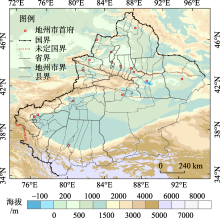
Fig. 1
Schematic diagram of the study area"

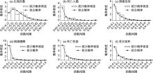
Fig. 2
Probability density distributions of the six kinds of wind disaster damage indices in Xinjiang"

Tab. 1
Statistical parameters of each element index of wind disaster in Xinjiang"
| 参数 | 出现次数 (A) | 死亡人数 (B) | 倒塌房屋数 (C) | 倒塌棚圈数 (D) | 牲畜死亡数量 (E) | 受灾面积 (F) | 县(市)综合 灾损(G) | 年综合 灾损(H) |
|---|---|---|---|---|---|---|---|---|
| 实际灾损最大值 | 77 | 28 | 2460 | 3572 | 46069 | 475312 | - | - |
| 指数平均值(μ) | 0.30 | 0.15 | 0.17 | 0.09 | 0.13 | 0.14 | 0.19 | 0.24 |
| 指数方差(σ2) | 0.04 | 0.03 | 0.04 | 0.03 | 0.03 | 0.03 | 0.02 | 0.04 |
| 形状参数(α) | 2.30 | 0.74 | 0.77 | 0.27 | 0.53 | 0.74 | 2.30 | 1.54 |
| 尺度参数(β) | 0.13 | 0.20 | 0.22 | 0.32 | 0.24 | 0.19 | 0.08 | 0.16 |
| 判识统计量(V) | 3.65 | 9.19 | 4.80 | 9.31 | 7.30 | 6.27 | 4.56 | 8.23 |
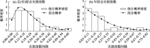
Fig. 3
Probability density distributions of the annual and county comprehensive damage indices of wind disasters in Xinjiang"


Fig. 4
Interannual variation of the composite damage index (wt) of wind disasters in Xinjiang"

Tab. 2
Grade standard of wind disasters and the annual composite damages in the county-level city and the whole regions over Xinjiang"
| 要素 | 特重(1级) | 严重(2级) | 较重(3级) | 一般(4级) |
|---|---|---|---|---|
| 累积分布函数(K) | K>0.90 | 0.75<K≤0.90 | 0.50<K≤0.75 | K≤0.50 |
| 出现次数(A) | A>0.56 | 0.40<A≤0.56 | 0.26<A≤0.40 | A≤0.26 |
| 死亡人数(B) | B>0.37 | 0.21<B≤0.37 | 0.09<B≤0.21 | B≤0.09 |
| 倒塌房屋数(C) | C>0.41 | 0.23<C≤0.41 | 0.10<C≤0.23 | C≤0.10 |
| 倒塌棚圈数(D) | D>0.26 | 0.09<D≤0.26 | 0.02<D≤0.09 | D≤0.02 |
| 牲畜死亡数量(E) | E>0.34 | 0.17<E≤0.34 | 0.06<E≤0.17 | E≤0.06 |
| 受灾面积(F) | F>0.34 | 0.19<F≤0.34 | 0.08<F≤0.19 | F≤0.08 |
| 县(市)综合灾损(G) | G>0.35 | 0.25<G≤0.35 | 0.16<G≤0.25 | G≤0.16 |
| 年综合灾损(H) | H>0.51 | 0.33<H≤0.51 | 0.19<H≤0.33 | H≤0.19 |
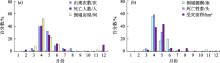
Fig. 5
Proportion of the six wind disaster damages in each month in Xinjiang"
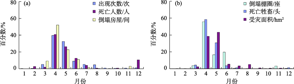
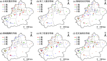
Fig. 6
Spatial distributions of the six elements of wind disasters under different grades in Xinjiang"

Fig. 7
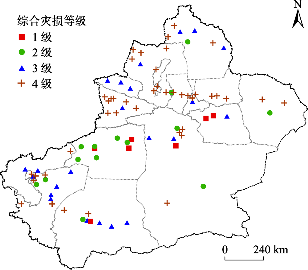
Spatial distribution of the composite damage index of wind disasters in Xinjiang"
| [1] | 张学文, 张家宝. 新疆气象手册[M]. 北京: 气象出版社, 2006: 185-189. |
| [ Zhang Xuewen, Zhang Jiabao. Xinjiang meteorological manual[M]. Beijing: China Meteorological Press, 2006: 185-189. ] | |
| [2] | 王秋香, 李红军. 新疆近20 a风灾研究[J]. 中国沙漠, 2003, 23(5):69-72. |
| [ Wang Qiuxiang, Li Hongjun. Analysis on gale disasters of Xinjiang in recent 40 years[J]. Journal of Desert Research, 2003, 23(5):69-72. ] | |
| [3] | 张家宝, 史玉光. 新疆气候变化及短期气候预测研究[M]. 北京: 气象出版社, 2002: 157-159. |
| [ Zhang Jiabao, Shi Yuguang. The research on climate change and prediction of short-term climate in Xinjiang[M]. Beijing: China Meteorological Press, 2002: 157-159. ] | |
| [4] | 邱博, 张录军, 谭慧慧. 中国大风集中程度及气候趋势研究[J]. 气象科学, 2013, 33(5):543-548. |
| [ Qiu Bo, Zhang Lujun, Tan Huihui. Study on gale concentration degree and climatic tendency in China[J]. Journal of Meteorological Sciences, 2013, 33(5):543-548. ] | |
| [5] | 王小玲, 宋文玲. 近30 a我国5级以上风日数的时空变化特征[J]. 气候变化研究进展, 2004, 62(2):228-236. |
| [ Wang Xiaoling, Song Wenling. Spatial and temporal variations in windy days over category 5 in China during 1975-2005[J]. Advances in Climate Change Research, 2004, 62(2):228-236. ] | |
| [6] | 张爱英, 任国玉, 郭军, 等. 近30 年我国高空风速变化趋势分析[J]. 高原气象, 2018, 28(3):680-687. |
| [ Zhang Aiying, Ren Guoyu, Guo Jun, et al. Change trend analyses on upper-air wind speed over China in past 30 years[J]. Plateau Meteorology, 2018, 28(3):680-687. ] | |
| [7] | 王毅荣, 张存杰. 河西走廊风速变化及风能资源研究[J]. 高原气象, 2006, 25(6):1196-1202. |
| [ Wang Yirong, Zhang Cunjie. Changes of wind speed and wind energy over Gansu Corridor[J]. Plateau Meteorology, 2006, 25(6):1196-1202. ] | |
| [8] | 谢今范, 刘玉英, 李宇凡. 吉林地面和高空风速变化特征及成因分析[J]. 高原气象, 2015, 34(5):1424-1434. |
| [ Xie Jinfan, Liu Yuying, Li Yufan. Variations and potential causes of surface and free atmospheric wind velocities in Jilin[J]. Plateau Meteorology, 2015, 34(5):1424-1434. ] | |
| [9] | 郭凌曜, 廖玉芳, 李晶, 等. 湖南历史风雹灾害序列构建及其变化特征[J]. 灾害学, 2018, 33(2):122-127. |
| [ Guo Lingyao, Liao Yufang, Li Jing, et al. Construct and variation characteristics of historical gale and hail disasters in Hunan[J]. Journal of Catastrophology, 2018, 33(2):122-127. ] | |
| [10] | 俞海洋, 李婷, 陈笑娟, 等. 河北省近30年大风时空分布及成灾特征分析[J]. 灾害学, 2017, 32(2):59-63. |
| [ Yu Haiyang, Li Ting, Chen Xiaojuan, et al. The spatio-temporal distribution and disaster characteristics analysis of the gale in Hebei Province for nearly 30 years[J]. Journal of Catastrophology, 2017, 32(2):59-63. ] | |
| [11] | 孙霞, 陈小雷, 俞海洋, 等. 河北省大风灾害及其危险性区划分析[J]. 中国农学通报, 2016, 32(1):183-187. |
| [ Sun Xia, Chen Xiaolei, Yu Haiyang, et al. Analysis of wind disaster and its hazard regionalization in Hebei Province[J]. Chinese Agricultural Science Bulletin, 2016, 32(1):183-187. ] | |
| [12] | 汤浩, 李如渏, 贾丽红. 新疆“2.28”大风的中尺度数值模拟[J]. 气象, 2011, 37(11):1365-1371. |
| [ Tang Hao, Li Ruqi, Jia Lihong. Mesoscale numerical simulation of the 28 February 2007 gale in Xinjiang[J]. Meteorological Monthly, 2011, 37(11):1365-1371. ] | |
| [13] | 汤浩, 王旭, 储长江, 等. 乌鲁木齐城区一次极端东南大风的形成机制--重力波与超低空急流耦合[J]. 干旱区地理, 2019, 42(6):1229-1238. |
| [ Tang Hao, Wang Xu, Chu Changjiang, et al. Formation mechanism of a southeast gale event in Urumqi urban area: The coupling of gravity wave and ultra-low level jet[J]. Arid Land Geography, 2019, 42(6):1229-1238. ] | |
| [14] | 王玉竹, 闫浩文, 王小平, 等. 新疆大风集中程度时空特征分析[J]. 干旱区地理, 2020, 43(3):623-632. |
| [ Wang Yuzhu, Yan Haowen, Wang Xiaoping, et al. Spatio-temporal analysis of gale concentration in Xinjiang[J]. Arid Land Geography, 2020, 43(3):623-632. ] | |
| [15] | 缪霄龙, 缪启龙, 宋健, 等. 杭州地区雷雨大风灾害风险区划[J]. 气象与减灾研究, 2012, 35(3):45-50. |
| [ Miao Xiaolong, Miao Qilong, Song Jian, et al. Risk zoning of thunderstrom gale disaster in Hangzhou[J]. Meteorology and Disaster Reduction Research, 2012, 35(3):45-50. ] | |
| [16] | 张丽娟, 陈红, 高玉宏, 等. 黑龙江省大风分布特征及风险区划研究[J]. 地理科学进展, 2011, 30(7):899-905. |
| [ Zhang Lijuan, Chen Hong, Gao Yuhong, et al. Study on the distribution and risk zoning of strong winds in Heilongjiang Province[J]. Progress in Geography, 2011, 30(7):899-905. ] | |
| [17] | 李兰, 周月华, 陈波. 湖北省大风灾害及其风险度[J]. 气象科技, 2009, 37(2):205-208. |
| [ Li Lan, Zhou Yuehua, Chen Bo. Wind disasters in Hubei Province and their risk degree[J]. Meteorological Science and Technology, 2009, 37(2):205-208. ] | |
| [18] | 宋建洋, 柳艳香, 田华, 等. 我国高速公路大风灾害风险评估与区划研究[J]. 公路, 2018, 63(12):182-187. |
| [ Song Jianyang, Liu Yanxiang, Tian Hua, et al. Risk assessment and zoning of gale disasters on expressway in China[J]. Highway, 2018, 63(12):182-187. ] | |
| [19] | 陈文友, 马志福, 马淑红, 等. 新疆公路风害风险区划研究[J]. 中国科技信息, 2013(15):139-141. |
| [ Chen Wenyou, Ma Zhifu, Ma Shuhong, et al. Regionalization research of Xinjiang highway wind damage risk[J]. China Science and Technology Information, 2013(15):139-141. ] | |
| [20] | 潘新民, 彭艳梅, 屈梅, 等. 新疆铁路沿线前百公里风区大风特征统计分析[J]. 沙漠与绿洲气象, 2019, 13(3):66-71. |
| [ Pan Xinmin, Peng Yanmei, Qu Mei, et al. Feature of gale along railway of the front 100-kilometers wind area in southern Xinjiang[J]. Desert and Oasis Meteorology, 2019, 13(3):66-71. ] | |
| [21] | 王建, 田浩, 庄文兵, 等. 过去三年新疆大风沙尘分布及电网吐哈线路大风灾害风险分析[J]. 气象科技进展, 2017, 7(2):24-31. |
| [ Wang Jian, Tian Hao, Zhuang Wenbing, et al. Distribution of gale dust in Xinjiang during the past three years and risk[J]. Advances in Meteorological Science and Technology, 2017, 7(2):24-31. ] | |
| [22] | 鲁天平, 郭靖, 陈梦, 等. 新疆林果产业大风沙尘灾害风险评估模型构建及区划[J]. 农业工程学报, 2016, 32(增刊2):169-176. |
| [ Lu Tianping, Guo Jing, Chen Meng, et al. Model establishment and zoning of wind-dust risk assessment to featured forestry and fruit industry in Xinjiang[J]. Transactions of the Chinese Society of Agricultural Engineering (Transactions of the CSAE), 2016, 32(Suppl. 2):169-176. ] | |
| [23] | 夏祎萌, 何清, 李军, 等. 新疆大风灾害灾度和危险度分析[J]. 中国沙漠, 2012, 32(4):1025-1028. |
| [ Xia Yimeng, He Qing, Li Jun, et al. Disaster degree and risk degree of wind disasters in Xinjiang[J]. Journal of Desert Research, 2012, 32(4):1025-1028. ] | |
| [24] | 杨龙, 何清. 新疆近3年大风灾害灾度分析与区划[J]. 灾害学, 2005, 20(4):83-86. |
| [ Yang Long, He Qing. Analysis on gale disaster degree in Xinjiang for 3 years and disaster zoning[J]. Journal of Catastrophology, 2005, 20(4):83-86. ] | |
| [25] | GB/T 35224-2017. 中华人民共和国国家标准: 地面气象观测规范——天气现象[S]. 北京: 中国标准出版社, 2017. |
| [GB/T 35224-2017. National standard of the People’s Republic of China: Specifications for surface meteorological observation: Weather phenomena[S]. Beijing: Higher Education Press, 2017. ] | |
| [26] | 陈家鼎, 刘婉如, 汪仁官. 概率统计讲义[M]. 第三版. 北京: 高等教育出版社, 2004: 57-64. |
| [ Chen Jiading, Liu Wanru, Wang Renguan. Probability and statistics[M]. 3rd ed. edition. Beijing: Higher Education Press, 2004: 57-64. ] | |
| [27] | 满苏尔·沙比提, 娜斯曼·那斯尔丁, 陆吐布拉·依明. 南疆近60年来风灾天气及灾度时空变化特征[J]. 地理研究, 2012, 31(5):803-810. |
| [ Sabit Mansur, Nasirdin Nasima, Imin Lotpulla. The spatio-temporal changes and intensity of gale disasters in southern Xinjiang in recent 60 years[J]. Geographical Research, 2012, 31(5):803-810. ] |
|
||