Arid Land Geography ›› 2023, Vol. 46 ›› Issue (3): 349-359.doi: 10.12118/j.issn.1000-6060.2022.315
• Climatology and Hydrology • Previous Articles Next Articles
ZHANG Ning1( ),WANG Zichen1(),YANG Xiao1,CHEN Tong2,XING Fei1
Received:2022-06-25
Revised:2022-10-27
Online:2023-03-25
Published:2023-03-31
Contact:
Zichen WANG
E-mail:zhedazhangning@126.com;201030040@hdu.edu.cn
ZHANG Ning,WANG Zichen,YANG Xiao,CHEN Tong,XING Fei. Coupling coordination and spatiotemporal differences between water resources and agriculture cropping system in Xinjiang: A case of grain and cotton cropping systems[J].Arid Land Geography, 2023, 46(3): 349-359.
Tab. 1
Coupling coordination comprehensive evaluation index system of composite system"
| 子系统 | 一级指标 | 二级指标 | 数据来源 | 属性 | 权重 |
|---|---|---|---|---|---|
| 水资源 | 水资源禀赋 | 人均水资源量/m3 | 统计年鉴获取 | + | 0.13 |
| 人均用水量/m3 | 统计年鉴获取 | - | 0.09 | ||
| 水资源利用 | 第一产业用水占比/% | 第一产业用水量/总用水量 | - | 0.12 | |
| 生活用水占比/% | 生活用水量/总用水量 | + | 0.10 | ||
| 生态环境用水占比/% | 生态环境用水量/总用水量 | + | 0.11 | ||
| 万元GDP用水量/m3·(104元)-1 | 地区GDP/总用水量 | - | 0.12 | ||
| 地下水供水占比/% | 地下水供水量/总用水量 | - | 0.11 | ||
| 中水利用量/109 m3 | 统计年鉴获取 | + | 0.09 | ||
| 水资源开发利用率/% | 总用水量/水资源总量 | - | 0.12 | ||
| 农业种植 | 种植投入 | 第一产业固定资产投资/104元 | 统计年鉴获取 | + | 0.10 |
| 化肥施用强度/t·hm-2 | 化肥施用量/耕地面积 | - | 0.10 | ||
| 劳均农作物播种面积/hm2·人-1 | 农作物播种面积/农业从业人员数 | + | 0.12 | ||
| 农业机械化水平/kW·hm-2 | 农业机械化总动力/耕地面积 | + | 0.11 | ||
| 有效灌溉面积/103 hm2 | 统计年鉴获取 | + | 0.12 | ||
| 水土流失治理面积/103 hm2 | 统计年鉴获取 | + | 0.09 | ||
| 种植产出 | 劳均农业总产值/104元·人-1 | 农业总产值/农业从业人员数 | + | 0.13 | |
| 单位面积粮食产量/kg·hm-2 | 统计年鉴获取 | + | 0.13 | ||
| 单位面积棉花产量/kg·hm-2 | 统计年鉴获取 | + | 0.11 |
Tab. 2
Discriminatory criteria of coordinated adaptation stage"
| 协调程度 | 耦合协调度(D) | 协调适配阶段 |
|---|---|---|
| 失调衰退区间 | [0.0, 0.1] | 极度失调衰退 |
| (0.1, 0.2] | 严重失调衰退 | |
| (0.2, 0.3] | 中度失调衰退 | |
| (0.3, 0.4] | 轻度失调衰退 | |
| 协调过渡区间 | (0.4, 0.5] | 濒临失调衰退 |
| (0.5, 0.6] | 勉强协调发展 | |
| 协调发展区间 | (0.6, 0.7] | 初级协调发展 |
| (0.7, 0.8] | 中级协调发展 | |
| (0.8, 0.9] | 良好协调发展 | |
| (0.9, 1.0] | 优质协调发展 |

Fig. 1
Trend of comprehensive development index of water resources system"

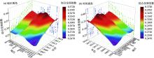
Fig. 2
Trend of comprehensive development index of agriculture cropping system"


Fig. 3
Trend of comprehensive development index of composite system"

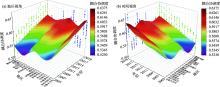
Fig. 4
Trend of the coupling coordination degree of composite system"

Tab. 3
Global Moran’s I of the coupling coordination degree of composite system from 2005 to 2019"
| 年份 | Moran’s I | P值 | Z值 | sd |
|---|---|---|---|---|
| 2005 | 0.419 | 0.010 | 2.894 | 0.173 |
| 2006 | 0.348 | 0.018 | 2.471 | 0.173 |
| 2007 | 0.288 | 0.031 | 1.971 | 0.171 |
| 2008 | 0.235 | 0.032 | 1.977 | 0.169 |
| 2009 | 0.280 | 0.030 | 2.127 | 0.171 |
| 2010 | 0.257 | 0.032 | 1.997 | 0.171 |
| 2011 | 0.334 | 0.016 | 2.465 | 0.169 |
| 2012 | 0.258 | 0.040 | 2.030 | 0.167 |
| 2013 | 0.236 | 0.040 | 1.973 | 0.163 |
| 2014 | 0.312 | 0.018 | 2.362 | 0.165 |
| 2015 | 0.300 | 0.022 | 2.365 | 0.161 |
| 2016 | 0.287 | 0.020 | 2.301 | 0.160 |
| 2017 | 0.326 | 0.018 | 2.461 | 0.165 |
| 2018 | 0.322 | 0.023 | 2.102 | 0.166 |
| 2019 | 0.311 | 0.016 | 2.357 | 0.165 |
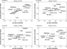
Fig. 5
Moran scatter plot of the coupling coordination degree of composite systems from 2005 to 2019"
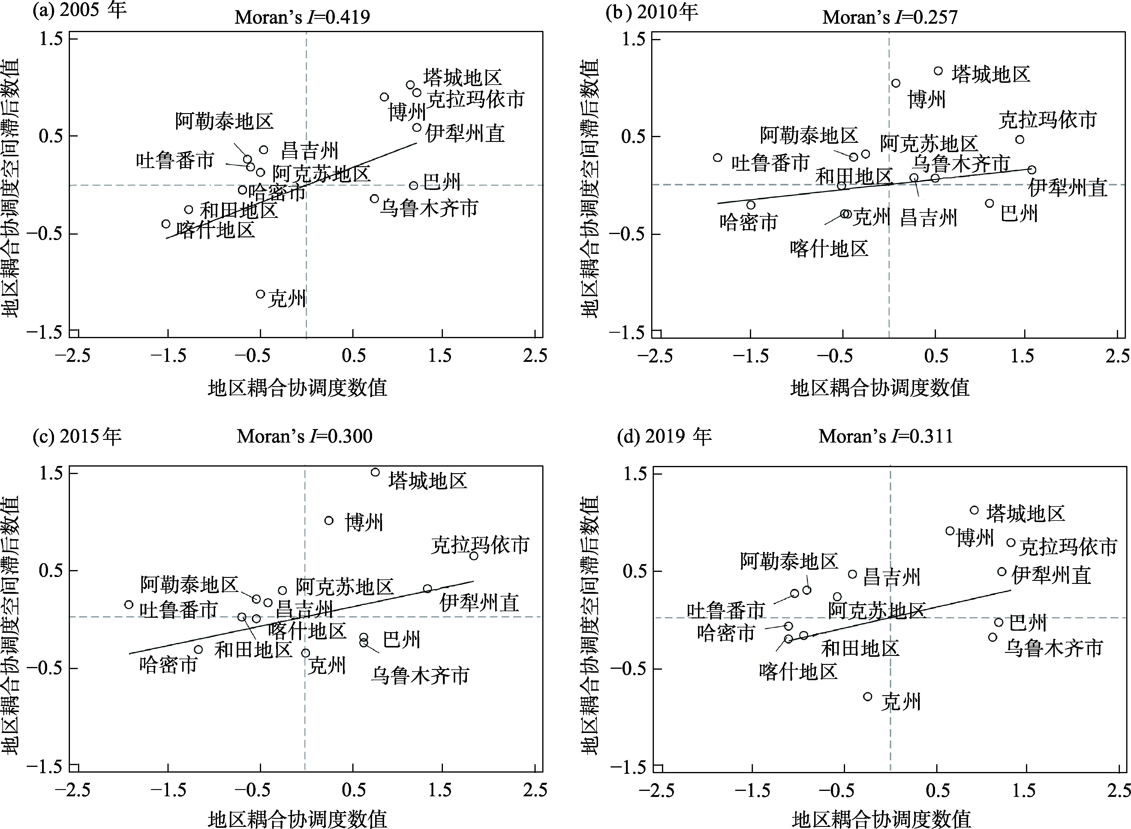

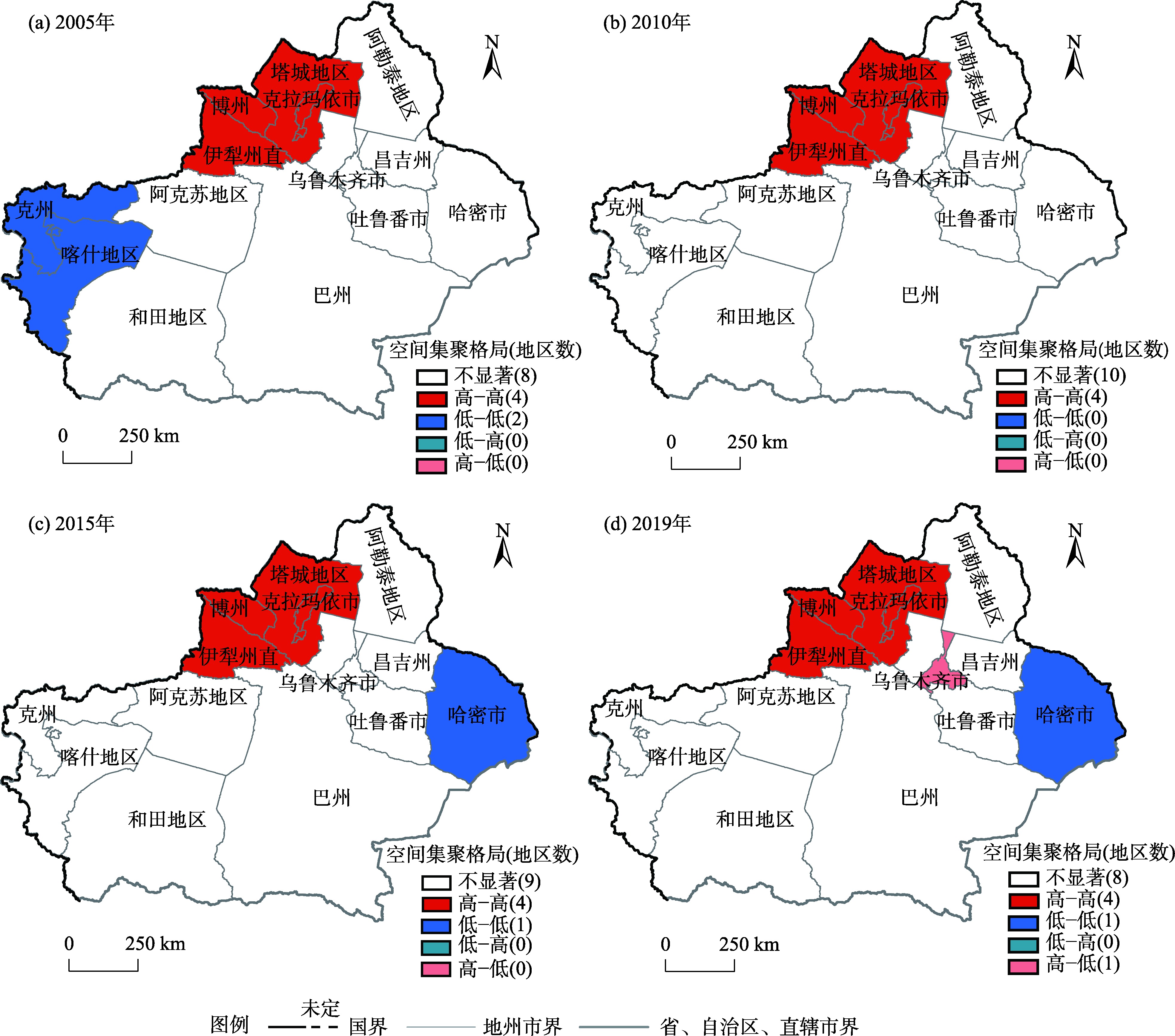
Fig. 6
LISA clustering map of the coupling coordination degree of composite systems from 2005 to 2019"
| [1] | 雒新萍, 刘晓洁. 中国典型农作物需水量及生产水足迹区域差异[J]. 节水灌溉, 2020(1): 88-93. |
| [ Luo Xinping, Liu Xiaojie. Regional differences on typical crop water requirement and water footprint in China from a production perspective[J]. Water Saving Irrigation, 2020(1): 88-93. ] | |
| [2] | 郎婷婷, 郝蒙蒙, 吴风华, 等. 基于DSSAT模型的京津冀地区主要农作物用水分析[J]. 干旱地区农业研究, 2019, 37(5): 235-242, 248. |
| [ Lang Tingting, Hao Mengmeng, Wu Fenghua, et al. Study on water requirements of major crops in Beijing-Tianjin-Hebei region using DSSAT model[J]. Agricultural Research in the Arid Areas, 2019, 37(5): 235-242, 248. ] | |
| [3] |
金涛. 中国粮食作物种植结构调整及其水土资源利用效应[J]. 自然资源学报, 2019, 34(1): 14-25.
doi: 10.31497/zrzyxb.20190102 |
|
[ Jin Tao. The adjustment of China’s grain cropping structure and its effect on the consumption of water and land resources[J]. Journal of Natural Resources, 2019, 34(1): 14-25. ]
doi: 10.31497/zrzyxb.20190102 |
|
| [4] | 张家欣, 邓铭江, 李鹏, 等. 虚拟水流视角下西北地区农业水资源安全格局与调控[J]. 中国工程科学, 2022, 24(1): 131-140. |
| [ Zhang Jiaxin, Deng Mingjiang, Li Peng, et al. Security pattern and regulation of agricultural water resources in northwest China from the perspective of virtual water flow[J]. Strategic Study of CAE, 2022, 24(1): 131-140. ] | |
| [5] | 吴勇, 张赓, 陈广锋, 等. 中国节水农业成效、形势机遇与展望[J]. 中国农业资源与区划, 2021, 42(11): 1-6. |
| [ Wu Yong, Zhang Geng, Chen Guangfeng, et al. Achievements, situation and opportunities of water saving agricultural in China and projections for future development[J]. Chinese Journal of Agricultural Resources and Regional Planning, 2021, 42(11): 1-6. ] | |
| [6] | 方芳, 马琼. 虚拟水价值视角下新疆主要农作物种植偏好及布局研究[J]. 节水灌溉, 2019, 44(7): 95-100. |
| [ Fang Fang, Ma Qiong. Study on planting preference and layout of main crops in Xinjiang from the perspective of virtual water value[J]. Water Saving Irrigation, 2019, 44(7): 95-100. ] | |
| [7] |
许航, 李韬, 宋健峰. 旱区农业灌溉用水反弹效应及其区域差异——以西北五省(区)为例[J]. 资源科学, 2021, 43(9): 1808-1820.
doi: 10.18402/resci.2021.09.08 |
|
[ Xu Hang, Li Tao, Song Jianfeng. Estimation, driving factors, and regional differences of agricultural irrigation water rebound effect in arid areas: Examples of five provinces in northwestern China[J]. Resources Science, 2021, 43(9): 1808-1820. ]
doi: 10.18402/resci.2021.09.08 |
|
| [8] |
孙才志, 张灿灿, 郜晓雯. 中国“四化”建设对水足迹强度的影响分析[J]. 自然资源学报, 2020, 35(4): 767-778.
doi: 10.31497/zrzyxb.20200402 |
|
[ Sun Caizhi, Zhang Cancan, Gao Xiaowen. Impact of China’s “four modernizations” on water footprint intensity[J]. Journal of Natural Resources, 2020, 35(4): 767-778. ]
doi: 10.31497/zrzyxb.20200402 |
|
| [9] | 杨晶. 乡村振兴战略推进下农业水资源节水激励机制研究[J]. 农业经济, 2020, 40(7): 12-14. |
| [ Yang Jing. Study on the incentive mechanism of agricultural water resources saving under the promotion of rural revitalization strategy[J]. Agricultural Economy, 2020, 40(7): 12-14. ] | |
| [10] |
罗巍, 杨玄酯, 杨永芳, 等. 黄河流域水-能源-粮食纽带关系协同演化及预测[J]. 资源科学, 2022, 44(3): 608-619.
doi: 10.18402/resci.2022.03.14 |
|
[ Luo Wei, Yang Xuanzhi, Yang Yongfang, et al. Co-evolution of water-energy-food nexus in the Yellow River Basin and forecast of future development[J]. Resources Science, 2022, 44(3): 608-619. ]
doi: 10.18402/resci.2022.03.14 |
|
| [11] | 李鸿飞, 何颖茹, 毕晓莉. 黄河流域兰州段生态环境与高质量发展耦合协调关系研究[J]. 干旱区地理, 2022, 45(4): 1244-1253. |
| [ Li Hongfei, He Yingru, Bi Xiaoli. Coupling coordination relationship between ecological environment and high-quality development in Lanzhou section of Yellow River Basin[J]. Arid Land Geography, 2022, 45(4): 1244-1253. ] | |
| [12] | 赵胡兰, 杨兆萍, 韩芳, 等. 新疆旅游产业—经济发展—生态环境耦合态势分析及预测[J]. 干旱区地理, 2020, 43(4): 1146-1154. |
| [ Zhao Hulan, Yang Zhaoping, Han Fang, et al. Analysis and forecast of coupling situation among tourism industry-economic development-ecological environment in Xinjiang[J]. Arid Land Geography, 2020, 43(4): 1146-1154. ] | |
| [13] | 金梦婷, 徐丽萍, 李鹏辉. 南北疆区域经济差异化三维生态足迹自然资本利用的时空演变[J]. 生态学报, 2020, 40(13): 4327-4339. |
| [ Jin Mengting, Xu Liping, Li Penghui. Spatial and temporal evolution of natural capital utilization in the three-dimensional ecological footprint under the regional economic differentiation in north and south Xinjiang[J]. Acta Ecologica Sinica, 2020, 40(13): 4327-4339. ] | |
| [14] |
D’Odorico P, Davis K F, Rosa L. The global food-energy-water nexus[J]. Reviews of Geophysics, 2018, 56(3): 456-531.
doi: 10.1029/2017RG000591 |
| [15] |
尚杰, 于浩然, 杨旭. 农业用水效率时空差异与影响因素分析[J]. 中国农业科技导报, 2022, 24(3): 11-19.
doi: 10.13304/j.nykjdb.2021.0346 |
|
[ Shang Jie, Yu Haoran, Yang Xu. Spatial temporal differences and influencing factors of agricultural water use efficiency[J]. Journal of Agricultural Science and Technology, 2022, 24(3): 11-19. ]
doi: 10.13304/j.nykjdb.2021.0346 |
|
| [16] | 刘楚杰, 李晓云, 聂媛. 基于重心模型的粮食生产与水资源时空耦合分析[J]. 农业现代化研究, 2021, 42(6): 1026-1036. |
| [ Liu Chujie, Li Xiaoyun, Nie Yuan. The spatio-temporal coupling analysis of grain production and water resources based on the barycenter model[J]. Research of Agricultural Modernization, 2021, 42(6): 1026-1036. ] | |
| [17] | 张继红, 刘云鹤, 王全九, 等. 典型作物Logistic模型生长参数空间分布及其地区水热相关性[J]. 干旱地区农业研究, 2021, 39(5): 199-209. |
| [ Zhang Jihong, Liu Yunhe, Wang Quanjiu, et al. Typical crops’ spatial variability of Logistic model parameters and its correlation with regional water and heat[J]. Agricultural Research in the Arid Areas, 2021, 39(5): 199-209. ] | |
| [18] |
赵雪雁, 高志玉, 马艳艳, 等. 2005—2014年中国农村水贫困与农业现代化的时空耦合研究[J]. 地理科学, 2018, 38(5): 717-726.
doi: 10.13249/j.cnki.sgs.2018.05.009 |
|
[ Zhao Xueyan, Gao Zhiyu, Ma Yanyan, et al. Spatio-temporal coupling between rural water poverty and agricultural modernization in China from 2005 to 2014[J]. Scientia Geographica Sinica, 2018, 38(5): 717-726. ]
doi: 10.13249/j.cnki.sgs.2018.05.009 |
|
| [19] |
屠爽爽, 郑瑜晗, 龙花楼, 等. 乡村发展与重构格局特征及振兴路径——以广西为例[J]. 地理学报, 2020, 75(2): 365-381.
doi: 10.11821/dlxb202002011 |
|
[ Tu Shuangshuang, Zheng Yuhan, Long Hualou, et al. Spatio-temporal pattern of rural development and restructuring and regional path of rural vitalization in Guangxi, China[J]. Scientia Geographica Sinica, 2020, 75(2): 365-381. ]
doi: 10.11821/dlxb202002011 |
|
| [20] | 田丰, 武建军, 刘雷震, 等. 1901—2015年华北平原干旱时空转移特征及热点区域探测[J]. 干旱区资源与环境, 2020, 34(6): 87-96. |
| [ Tian Feng, Wu Jianjun, Liu Leizhen, et al. Spatiotemporal transferring characteristics of drought and its hotpots detection in North China Plain during 1901—2015[J]. Journal of Arid Land Resources and Environment, 2020, 34(6): 87-96. ] | |
| [21] | 徐依婷, 穆月英, 侯玲玲. 水资源稀缺性、灌溉技术采用与节水效应[J]. 农业技术经济, 2022, 41(2): 47-61. |
| [ Xu Yiting, Mu Yueying, Hou Lingling. Water scarcity, adoption of irrigation technologies and water conservation[J]. Journal of Agrotechnical Economics, 2022, 41(2): 47-61. ] |
|
||