Arid Land Geography ›› 2021, Vol. 44 ›› Issue (4): 1083-1092.doi: 10.12118/j.issn.1000–6060.2021.04.20
• Earth Information Sciences • Previous Articles Next Articles
LU Zhuoyu1( ),CUI Jianxin1(),ZHANG Xiaohong2,LI Peng1
Received:2020-07-08
Revised:2020-10-04
Online:2021-07-25
Published:2021-08-02
Contact:
Jianxin CUI
E-mail:luzhuoyu@snnu.edu.cn;cuijx@snnu.edu.cn
LU Zhuoyu,CUI Jianxin,ZHANG Xiaohong,LI Peng. Historical changes reconstruction of Tonghalake Lake in the Mu Us Sandy Land from Qing Dynasty to Republic of China[J].Arid Land Geography, 2021, 44(4): 1083-1092.
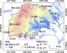
Fig. 1
Modern river system of Mu Us Sandy Land"

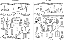
Fig. 2
Locations of ancient lakes shown in Shaanxi Sizhen Tushuo"

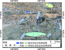
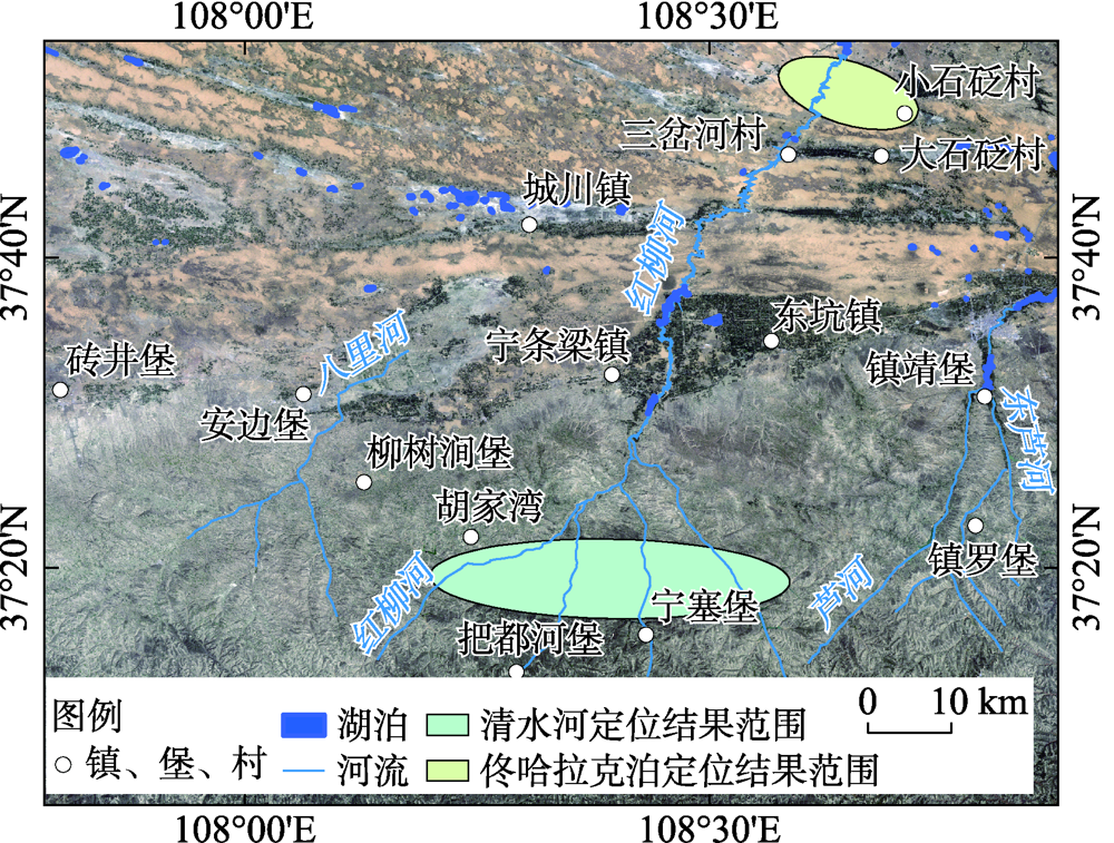
Fig. 3
Positioning results of Tonghalake Lake based on historical documents"
Tab. 1
Comparison of mileage recorded in historical documents and actual distance"
| 参考地物 | 文献记载距离/里 | 换算距离a/km | 实际直线距离/km | 估算实际道路距离b/km |
|---|---|---|---|---|
| 左翼中旗(今伊金霍洛旗阿勒腾席热镇)至神木(今神木市)界 | 200 | 124.20 | 99 | 122 |
| 右翼前旗(今乌审旗东北巴吉代)至榆林(今榆林市榆阳区)界 | 230 | 142.83 | 99 | 136 |
Tab. 2
Differences of longitude and latitude and offset distance of Huangyu Quanlantu relative to the real location"
| 参考地物 | 图上坐标与实地坐标差值 | 偏移距离/km | |
|---|---|---|---|
| 经度差/(°) | 纬度差/(°) | ||
| 安定堡 | -0.0142 | -0.0355 | 4.1355 |
| 高平堡 | -0.0288 | -0.0154 | 3.0616 |
| 花马池 | -0.0286 | -0.0401 | 5.1222 |
| 盐场堡 | -0.0452 | 0.0091 | 4.1185 |
| 定边营 | 0.0121 | 0.0092 | 1.4818 |
| 砖井堡 | 0.0228 | 0.0295 | 3.8468 |
| 安边堡 | -0.0042 | 0.0231 | 2.5860 |
| 宁塞堡 | -0.0017 | 0.0014 | 0.2185 |
| 靖边营 | 0.0327 | -0.0049 | 2.9528 |
| 镇罗堡 | -0.0141 | -0.0011 | 1.2578 |
| 镇靖堡 | 0.0015 | -0.0216 | 2.4025 |
| 龙州堡 | -0.0088 | -0.0033 | 0.8607 |
| 榆林卫 | 0.0077 | -0.0805 | 8.9563 |
| 高家堡 | -0.0114 | -0.0503 | 5.6685 |
| 柏林堡 | 0.0086 | 0.0469 | 5.2555 |
| 神木县 | -0.0381 | 0.0073 | 3.4020 |
| 孤山堡 | 0.0020 | -0.0116 | 1.2952 |
| 府谷县 | 0.0358 | 0.0034 | 3.1170 |
| 差值平均数 | -0.0040 | -0.0075 | 3.3189 |
Tab. 3
Differences of longitude and latitude and offset distance of Yongzheng Shipaitu relative to the real location"
| 参考地物 | 图上坐标与实地坐标差值 | 偏移距离/km | |
|---|---|---|---|
| 经度差/(°) | 纬度差/(°) | ||
| 安定堡 | 0.0006 | -0.0060 | 0.6645 |
| 高平堡 | 0.0073 | -0.0030 | 0.7237 |
| 花马池 | -0.0127 | -0.0080 | 1.4305 |
| 盐场堡 | 0.0332 | -0.0322 | 4.6268 |
| 定边县 | 0.0366 | 0.0006 | 3.2366 |
| 砖井堡 | 0.0709 | 0.0185 | 6.5967 |
| 安边堡 | 0.0260 | 0.0303 | 4.0750 |
| 宁塞堡 | 0.0069 | 0.0198 | 2.2775 |
| 靖边营 | 0.0078 | 0.0205 | 2.3798 |
| 镇罗堡 | -0.0452 | 0.0257 | 4.9184 |
| 镇靖堡 | -0.0075 | -0.0015 | 0.6880 |
| 龙州堡 | -0.0071 | 0.0097 | 1.2439 |
| 榆林卫 | -0.0637 | -0.0261 | 6.2836 |
| 高家堡 | 0.0235 | -0.0846 | 9.6058 |
| 柏林堡 | 0.0187 | 0.0345 | 4.1580 |
| 神木县 | 0.0891 | 0.0432 | 9.0978 |
| 孤山堡 | -0.0205 | 0.0233 | 3.1378 |
| 府谷县 | -0.0376 | 0.0006 | 3.2578 |
| 差值平均数 | 0.0070 | 0.0036 | 3.8001 |
Tab. 4
Differences of longitude and latitude and offset distance of Qianlong Neifu Yutu relative to the real location"
| 参考地物 | 图上坐标与实地坐标差值 | 偏移距离/km | |
|---|---|---|---|
| 经度差/(°) | 纬度差/(°) | ||
| 安定堡 | 0.0276 | -0.0073 | 2.5578 |
| 高平堡 | -0.0077 | 0.0295 | 3.3489 |
| 花马池 | -0.0462 | -0.0011 | 4.0770 |
| 盐场堡 | -0.0817 | 0.0331 | 8.0928 |
| 定边县 | 0.0090 | 0.0549 | 6.1524 |
| 砖井堡 | 0.0411 | -0.0202 | 4.2687 |
| 安边堡 | -0.0122 | -0.0367 | 4.2121 |
| 宁塞堡 | -0.0110 | -0.0031 | 1.0326 |
| 靖边县 | 0.0110 | -0.0213 | 2.5616 |
| 镇罗堡 | 0.0121 | 0.0548 | 6.1763 |
| 镇靖堡 | 0.1016 | -0.0277 | 9.4950 |
| 龙州堡 | -0.0011 | 0.0567 | 6.2919 |
| 榆林县 | 0.0012 | -0.0676 | 7.5041 |
| 高家堡 | -0.0652 | -0.0130 | 5.8603 |
| 柏林堡 | -0.0602 | 0.0101 | 5.3618 |
| 神木县 | -0.0728 | 0.0442 | 8.0018 |
| 孤山堡 | -0.0038 | 0.0132 | 1.5063 |
| 府谷县 | -0.0315 | 0.0313 | 4.4174 |
| 差值平均值 | -0.0105 | 0.0072 | 5.0510 |
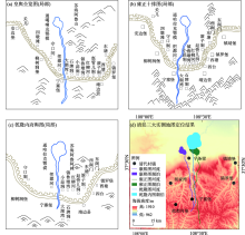
Fig. 4
Locations of Tonghalake Lake in the three maps during the Qing Dynasty"

| [1] | 胡汝骥, 姜逢清, 王亚俊, 等. 论中国干旱区湖泊研究的重要意义[J]. 干旱区研究, 2007, 24(2):137-140. |
| [ Hu Ruji, Jiang Fengqing, Wang Yajun, et al. On the importance of research on the lakes in arid land of China[J]. Arid Zone Research, 2007, 24(2):137-140. ] | |
| [2] | 桑广书, 李芳, 杨晓敏. 鄂尔多斯高原明长城的地理界线意义[J]. 干旱区地理, 2017, 40(3):485-493. |
| [ Sang Guangshu, Li Fang, Yang Xiaomin. Significance of the Great Wall of Ming Dynasty in Ordos Plateau as geographical boundary[J]. Arid Land Geography, 2017, 40(3):485-493. ] | |
| [3] |
Liu K, Lai Z P. Chronology of Holocene sediments from the archaeological Salawusu site in the Mu Us Desert in China and its palaeoenvironmental implications[J]. Journal of Asian Earth Sciences, 2012, 45:247-255.
doi: 10.1016/j.jseaes.2011.11.002 |
| [4] |
舒培仙, 李保生, 牛东风, 等. 毛乌素沙漠东南缘滴哨沟湾剖面DGS1层段粒度特征及其指示的全新世气候变化[J]. 地理科学, 2016, 36(3):448-457.
doi: 10.13249/j.cnki.sgs.2016.03.017 |
|
[ Shu Peixian, Li Baosheng, Niu Dongfeng, et al. Climate variations recorded by the grain-size from the DGS1 segment in the southeast of China’s Mu Us Desert during the Holocene[J]. Scientia Geographica Sinica, 2016, 36(3):448-457. ]
doi: 10.13249/j.cnki.sgs.2016.03.017 |
|
| [5] |
Jia F F, Lu R J, Liu X K, et al. Palaeoenvironmental implications of a Holocene sequence of lacustrine-peat sediments from the desert-loess transitional zone in northern China[J]. Journal of Asian Earth Sciences, 2018, 156:167-173.
doi: 10.1016/j.jseaes.2018.01.030 |
| [6] | 侯仁之. 从红柳河上的古城废墟看毛乌素沙漠的变迁[J]. 文物, 1973(1):35-41. |
| [ Hou Renzhi. From the ruins of the ancient city on the Red Willow River to see the changes of the Mu Us Desert[J]. Cultural Relics, 1973(1):35-41. ] | |
| [7] | 朱士光. 内蒙城川地区湖泊的古今变迁及其与农垦之关系[J]. 农业考古, 1982(1):14-18, 157. |
| [ Zhu Shiguang. The ancient and modern changes of lakes in the Chengchuan area of Inner Mongolia and its relationship with farmland reclamation[J]. Agricultural Archaeology, 1982(1):14-18, 157. ] | |
| [8] |
Huang Y Z, Wang N A, He T H, et al. Historical desertification of the Mu Us Desert, northern China: A multidisciplinary study[J]. Geomorphology, 2009, 110(3-4):108-117.
doi: 10.1016/j.geomorph.2009.03.020 |
| [9] |
Cui J X, Chang H, Cheng K Y, et al. Climate change, desertification, and societal responses along the Mu Us Desert margin during the Ming Dynasty[J]. Weather, Climate, and Society, 2017, 9(1):81-94.
doi: 10.1175/WCAS-D-16-0015.1 |
| [10] | 赵永复. 历史上毛乌素沙地的变迁问题[J]. 历史地理, 1981(1):34-47. |
| [ Zhao Yongfu. Changes of the Mu Us Sandy Land in history[J]. Historical Geography, 1981(1):34-47. ] | |
| [11] | 高嘉诚. 清代鄂尔多斯高原水环境的历史考察[D]. 西安: 陕西师范大学, 2005. |
| [ Gao Jiacheng. The historical investigation of the the Qing’s water environment in Ordos Plateau[D]. Xi’an: Shaanxi Normal University, 2005. ] | |
| [12] | 罗凯, 安介生. 清代鄂尔多斯水文系统初探[C]//侯甬坚. 鄂尔多斯高原及其邻区历史地理研究. 西安: 三秦出版社, 2008: 274-297. |
| [ Luo Kai, An Jiesheng. A preliminary study of the Ordos hydrological system in the Qing Dynasty[C]//Hou Yongjian. Research on the historical geography of the Ordos Plateau and its neighboring areas. Xi’an: Sanqin Publishing House, 2008: 274-297. ] | |
| [13] | 黄银洲, 李婧, 付娇, 等. 萨拉乌苏河对芦河的袭夺及其历史地理意义[J]. 中国沙漠, 2020, 40(3):7-15. |
| [ Huang Yinzhou, Li Jing, Fu Jiao, et al. River piracy of the Lu River by the Salawusu River and its historical-geographical significance[J]. Journal of Desert Research, 2020, 40(3):7-15. ] | |
| [14] | 张莉, 李有利. 近300年来新疆玛纳斯湖变迁研究[J]. 中国历史地理论丛, 2004, 19(4):127-142, 160. |
| [ Zhang Li, Li Youli. On the changes of Manas Lake in the past 300 years[J]. Journal of Chinese Historical Geography, 2004, 19(4):127-142, 160. ] | |
| [15] | 何彤慧, 王乃昂, 黄银洲, 等. 毛乌素沙地古城反演的地表水环境变化[J]. 中国沙漠, 2010, 30(3):471-476. |
| [ He Tonghui, Wang Nai’ang, Huang Yinzhou, et al. Surface water environment change of the Mu Us Desert during historic times: An ancient city perspective[J]. Journal of Desert Research, 2010, 30(3):471-476. ] | |
| [16] | 邓辉, 李羿. 人地关系视角下明清时期京津冀平原东淀湖泊群的时空变化[J]. 首都师范大学学报(社会科学版), 2018, 243(4):95-105. |
| [ Deng Hui, Li Yi. The temporal and spatial changes of the Dongdian Lake Group in the Jingjinji Plain in the Ming and Qing Dynasties from the perspective of human-land relationship[J]. Journal of Capital Normal University(Social Sciences Edition), 2018, 243(4):95-105. ] | |
| [17] |
杨霄, 韩昭庆. 1717—2011年高宝诸湖的演变过程及其原因分析[J]. 地理学报, 2018, 73(1):129-137.
doi: 10.11821/dlxb201801011 |
|
[ Yang Xiao, Han Zhaoqing. The change of the Gaobao lakes and its driving forces (1717—2011)[J]. Acta Geography Sinica, 2018, 73(1):129-137. ]
doi: 10.11821/dlxb201801011 |
|
| [18] | 王涛. 中国北方沙漠与沙漠化图集[M]. 北京: 科学出版社, 2014: 22. |
| [ Wang Tao. Atlas of deserts and desertification in northern China[M]. Beijing: Science Press, 2014: 22. ] | |
| [19] | 闫峰, 吴波. 近40 a毛乌素沙地荒漠化过程研究[J]. 干旱区地理, 2013, 36(6):987-996. |
| [ Yan Feng, Wu Bo. Desertification progress in Mu Us Sandy Land over the past 40 years[J]. Arid Land Geography, 2013, 36(6):987-996. ] | |
| [20] | 张佩云, 王凯, 王戈飞, 等. 毛乌素沙地中部地表水体1999—2015时空动态变化特征及驱动分析[J]. 干旱区地理, 2017, 40(3):633-639. |
| [ Zhang Peiyun, Wang Kai, Wang Gefei, et al. Spatial-temporal changes and factor analysis of surface water in the middle Mu Us Sandy Land areas from 1999 to 2015[J]. Arid Land Geography, 2017, 40(3):633-639. ] | |
| [21] | 牛润珍, 张慧. 《大清一统志》纂修考述[J]. 清史研究, 2008(1):136-148. |
| [ Niu Runzhen, Zhang Hui. The compilation of gazetteer of the unified Great Qing[J]. The Qing History Journal, 2008(1):136-148. ] | |
| [22] | 韩昭庆. 康熙《皇舆全览图》的数字化及意义[J]. 清史研究, 2016(4):53-60. |
| [ Han Zhaoqing. The digitization of Kangxi complete atlas of imperial tenitories and its significance for the study of environmental change and historical geography[J]. The Qing History Journal, 2016(4):53-60. ] | |
| [23] | 喻沧, 刘自健. 《中国测绘史》编辑委员会编. 中国测绘史[M]. 北京: 测绘出版社, 2002: 571-579. |
| [ Yu Cang, Liu Zijian. Edited by the Editorial Committee of “History of Surveying and Mapping in China”. History of surveying and mapping in China[M]. Beijing: Surveying and Mapping Press, 2002: 571-579. ] | |
| [24] | 陆俊巍, 韩昭庆, 诸玄麟, 等. 康熙《皇舆全览图》投影种类的统计分析[J]. 测绘科学, 2011, 36(6):16-18, 27. |
| [ Lu Junwei, Han Zhaoqing, Zhu Xuanlin, et al. A statistical analysis on the projection type applied in Huang Yu Quan Lan Tu[J]. Science of Surveying and Mapping, 2011, 36(6):16-18, 27. ] | |
| [25] | (清) 穆彰阿, 潘锡恩. 大清一统志(第12册)[M]. 上海: 上海古籍出版社, 2008: 599-602. |
| [(Qing) Mu Zhang’a, Pan Xi’en. Chorography in Qing Dynasty(Vol.12)[M]. Shanghai: Shanghai Ancient Books Publishing House, 2008: 599-602. ] | |
| [26] | 李大海. 明清时期陕北宁塞营堡城址考辩——兼及明代把都河、永济诸堡的定位[C]//侯甬坚. 鄂尔多斯高原及其邻区历史地理研究. 西安: 三秦出版社, 2008: 274-297. |
| [ Li Dahai. A research on the city site of Ningsaiyingbao in northern Shaanxi during the Ming and Qing Dynasties and the position of Badu River and Yongji castles in the Ming Dynasty[C]//Hou Yongjian. Research on the historical geography of the Ordos Plateau and its neighboring areas. Xi’an: Sanqin Publishing House, 2008: 274-297. ] | |
| [27] | (清) 张穆. 蒙古游牧记[M]. 台北: 文海出版社, 1965: 255. |
| [(Qing) Zhang Mu. Mongolian nomads[M]. Taipei: Wenhai Publishing House, 1965: 255. ] | |
| [28] | 伊克昭盟地名委员会. 伊克昭盟地名志[R]. 呼和浩特: 内蒙古自治区地名委员会, 1986: 318. |
| [Place Names Committee of Yikezhao League. Place names of Yikezhao League[R]. Hohhot: Place Names Committee of Inner Mongolia Autonomous Region, 1986: 318. ] | |
| [29] | (比) 田清波. 对萨囊·彻辰的曾祖父——库图克台·彻辰·洪·台吉的说明[C]// 伊克昭盟档案馆. 鄂尔多斯研究文集第一辑(内部资料). 鄂尔多斯: 内蒙古伊克昭盟档案馆, 1984: 73-78. |
| [ Antoine Mostaert. An explanation of Kutuket Chechen Hong Taiji, great grandfather of Sagang Chechen[C]// Yikezhao League Archives. Research essays of Ordos, Volume 1(internal publication). Ordos: Inner Mongolia Yikezhao League Archives, 1984: 73-78. ] | |
| [30] | (清) 萨囊彻辰, 道润梯步译校. 蒙古源流(新译校注)[M]. 呼和浩特: 内蒙古人民出版社, 1980: 353. |
| [(Qing) Sagang Chechen, Translated by Daorun Tibu. Origin of Mongolia(New Translation Notes)[M]. Hohhot: Inner Mongolia People’s Publishing House, 1980: 353. ] | |
| [31] | 汪前进, 刘若芳. 清廷三大实测全图集[M]. 北京: 外文出版社, 2007. |
| [ Wang Qianjin, Liu Ruofang. The Qing Dynasty three surveyed map[M]. Beijing: Foreign Languages Press, 2007. ] | |
| [32] | 白壮壮. 清代以来鄂尔多斯高原沙漠化定量研究[D]. 西安: 陕西师范大学, 2020. |
| [ Bai Zhuangzhuang. Quantitative research on the desertification of the Ordos Plateau since the Qing Dynasty[D]. Xi’an: Shaanxi Normal University, 2020. ] | |
| [33] | 绥远通志馆编纂. 绥远通志稿(第1册)[M]. 呼和浩特: 内蒙古人民出版社, 2007: 402. |
| [Compiled by Suiyuan Tongzhi Department. Suiyuan tongzhi draft(Vol. 1)[M]. Hohhot: Inner Mongolia People’s Publishing House, 2007: 402. ] | |
| [34] | 罗小庆, 赵景波, 马晓华. 陕西省榆林地区1644—1949年旱灾与干旱气候事件[J]. 水土保持通报, 2015, 35(1):311-316. |
| [ Luo Xiaoqing, Zhao Jingbo, Ma Xiaohua. Drought disaster and drought events in Yulin area of Shaanxi Province from 1644 to 1949[J]. Bulletin of Soil and Water Conservation, 2015, 35(1):311-316. ] | |
| [35] | 李明启, 靳鹤龄, 张洪. 小冰期气候的研究进展[J]. 中国沙漠, 2005, 25(5):731-737. |
| [ Li Mingqi, Jin Heling, Zhang Hong. Advances of climate research in the Little Ice Age[J]. Journal of Desert Research, 2005, 25(5):731-737. ] | |
| [36] | 白壮壮, 崔建新. 近2000 a毛乌素沙地沙漠化及成因[J]. 中国沙漠, 2019, 39(2):177-185. |
| [ Bai Zhuangzhuang, Cui Jianxin. Desertification and its causes in Mu Us Desert in recent 2000 years[J]. Journal of Desert Research, 2019, 39(2):177-185. ] | |
| [37] | 张世明. 清代“烧荒”考[J]. 清史研究, 2005(3):85-88. |
| [ Zhang Shiming. Textual research on “Burning Waste” in the Qing Dynasty[J]. The Qing History Journal, 2005(3):85-88. ] | |
| [38] | 张力仁. 清代伊克昭盟南部“禁留地”新探[J]. 中国历史地理论丛, 2018, 33(4):87-94. |
| [ Zhang Liren. New exploration of the “Forbidden Land” in the southern part of Yike Zhao League in the Qing Dynasty[J]. Journal of Chinese Historical Geography, 2018, 33(4):87-94. ] | |
| [39] | 王晗. 清代陕北长城外伙盘地研究[D]. 西安: 陕西师范大学, 2005. |
| [ Wang Han. The disquisition on Huo Pan Di at the outside of the Great Wall in the north of Shaanxi in the Qing Dynasty[D]. Xi’an: Shaanxi Normal University, 2005. ] | |
| [40] | (清) 白翰章. 靖边县志稿[M]. 台北: 成文出版社, 1970: 313. |
| [(Qing) Bai Hanzhang. Chorography manuscript of Jingbian County[M]. Taipei: Chengwen Publishing House, 1970: 313. ] | |
| [41] | 王晗, 郭平若. 清代垦殖政策与陕北长城外的生态环境[J]. 史学月刊, 2007(4):86-93. |
| [ Wang Han, Guo Pingruo. The Qing Dynasty reclamation policy and ecological environment outside the Great Wall in northern Shaanxi[J]. Journal of Historical Science, 2007(4):86-93. ] | |
| [42] | 西北大学地理系《陕西农业地理》编写组编. 陕西农业地理[M]. 西安: 陕西人民出版社, 1979: 123. |
| [Editing group of Shaanxi Agricultural Geography, Geography Department of Northwest University. Shaanxi agricultural geography[M]. Xi’an: Shaanxi People’s Publishing House, 1979: 123. ] |
| [1] | PAN Xue, GUAN Yuqi, PAN Zhandong, LIU Jie, CAI Liqun, DONG Bo, DU Jian. Spatiotemporal variation and evaluation of cultivated land quality grade in arid areas: A case of Xining City [J]. Arid Land Geography, 2023, 46(5): 793-803. |
| [2] | XIE Conghui,WU Shixin,LIN Juan,ZHUANG Qingwei,ZHANG Zihui,HOU Guanyu,LUO Geping. Analysis of cultivated land salinization in Kashgar Oasis based on PSO-PNN model [J]. Arid Land Geography, 2022, 45(5): 1547-1558. |
| [3] | HE Junqi,WEI Yan,GAO Wande,CHEN Yunfei,MA Yandong,LIU Xiuhua. Temporal and spatial variation of vegetation NDVI and its response to climatic factors in the southeastern margin of Mu Us Sandy Land [J]. Arid Land Geography, 2022, 45(5): 1523-1533. |
| [4] | TANG Yuanhang,LI Mengqi,DENG Ling,WANG Xiaoli. Glacier change and its response to climate change in Pumqu Basin during 1990—2020 [J]. Arid Land Geography, 2022, 45(1): 27-36. |
| [5] | CUI Ying-ying, ZHOU Ya-li, CHEN Guo-xiang, HUANG Chun-chang, PANG Jiang-Li, YANG Jun-min, YAN Xue-jiao. Mineral quantitative analysis of Mu Us Sandy Land with QEMSCAN [J]. Arid Land Geography, 2020, 43(6): 1505-1513. |
| [6] | WANG Long, GAO Guang lei, ZHANG Ying, DING Guo-dong, ZHAO Yuan-yuan, PENG Le. Particle size distribution of aeolian soils in the Mu Us Sandy Land and the influence factors [J]. Arid Land Geography, 2019, 42(5): 1003-1010. |
| [7] | ZHANG Pei-yun, WANG Kai, WANG Ge-fei, LIANG Li-wen, ZHANG Shi-qiang. Spatial-temporal changes and factor analysis of surface water in the middle Mu Us Sandy Land areas from 1999 to 2015 [J]. , 2017, 40(3): 633-639. |
| [8] | WANG Bing,AN Hui-jun,LV Chang-wei. Spatial variations of dissolved oxygen in Hulun Lake using geostatistics and GIS technology [J]. , 2013, 36(6): 1103-1110. |
| [9] | YAN Feng,WU Bo. Desertification progress in Mu Us Sandy Land over the past 40 years [J]. , 2013, 36(6): 987-996. |
|
||