Arid Land Geography ›› 2021, Vol. 44 ›› Issue (2): 471-483.doi: 10.12118/j.issn.1000–6060.2021.02.18
• Earth Information Sciences • Previous Articles Next Articles
YU Linfei1,2( ),YANG Yonghui1,YANG Yanmin1()
Received:2020-04-20
Revised:2020-07-24
Online:2021-03-25
Published:2021-04-14
Contact:
Yanmin YANG
E-mail:yulf.20b@igsnrr.ac.cn;yonghui.yang@sjziam.ac.cn
YU Linfei,YANG Yonghui,YANG Yanmin. Evolution and frontier development of research on evaluation of satellite precipitation product[J].Arid Land Geography, 2021, 44(2): 471-483.
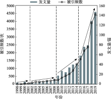
Fig. 1
Number of cited and published papers on evaluation of satellite precipitation product from 1998 to 2020"
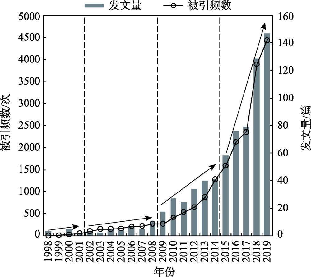
Fig. 2
Major disciplines and their proportions in evaluation of satellite precipitation product"
Tab. 1
Top ten countries of the number of published papers around the world"
| 排名 | 国家/地区 | 记录 | 发文量占比/% | h指数 | 每项平均被引用次数 | 被引次总计 | 去除自引 |
|---|---|---|---|---|---|---|---|
| 1 | 美国(USA) | 336 | 44.68 | 61 | 38.37 | 12893 | 11610 |
| 2 | 中国(China) | 237 | 31.52 | 33 | 17.39 | 4122 | 2981 |
| 3 | 德国(Germany) | 59 | 7.85 | 23 | 24.32 | 1435 | 1396 |
| 4 | 英国(England) | 54 | 7.18 | 26 | 71.28 | 3849 | 3820 |
| 5 | 意大利(Italy) | 48 | 6.38 | 20 | 27.75 | 1332 | 1293 |
| 6 | 印度(India) | 46 | 6.12 | 15 | 13.72 | 631 | 574 |
| 7 | 法国(France) | 44 | 5.85 | 18 | 32.73 | 1440 | 1409 |
| 8 | 荷兰(Netherlands) | 39 | 5.19 | 20 | 31.54 | 1230 | 1194 |
| 9 | 澳大利亚(Australia) | 31 | 4.12 | 15 | 33.35 | 1034 | 1021 |
| 10 | 日本(Japan) | 26 | 3.46 | 13 | 35.42 | 921 | 914 |

Fig. 3
Map of published papers and cooperation between countries and regions"

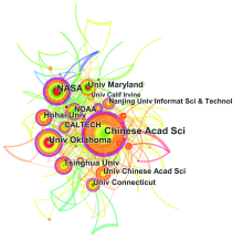
Fig. 4
Map of institutional cooperation"

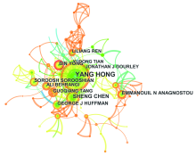
Fig. 5
Network of author cooperation"

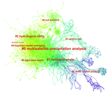
Fig. 6
Literature co-citation analysis map in evaluation of satellite precipitation product"

Tab. 2
Co-citation analysis of evaluation of satellite precipitation product in Web of Science dataset"
| 频次 | 第一作者 | 发表年份 | 题目 | 期刊 |
|---|---|---|---|---|
| 137 | Huffman G J | 2007 | The TRMM multisatellite precipitation analysis (TMPA): Quasi-global, multiyear, combined-sensor precipitation estimates at fine scales | Journal of Hydrometeorology |
| 136 | Hou A Y | 2014 | The global precipitation measurement mission | Bulletin of the American Meteorological Society |
| 91 | Tang G Q | 2016 | Evaluation of GPM Day-1 IMERG and TMPA Version-7 legacy products over mainland China at multiple spatiotemporal scales | Journal of Hydrology |
| 90 | Ashouri H | 2015 | PERSIANN-CDR: Daily precipitation climate data record from multisatellite observations for hydrological and climate studies | Bulletin of the American Meteorological Society |
| 79 | Dee D P | 2011 | The ERA-Interim reanalysis: Configuration and performance of the data assimilation system | Quarterly Journal of the Royal Meteorological Society |
| 75 | Behrangi A | 2011 | Hydrological evaluation of satellite precipitation products over a mid-size basin | Journal of Hydrology |
| 71 | Ebert E E | 2007 | Comparison of near-real-time precipitation estimates from satellite observations and numerical models | Bulletin of the American Meteorological Society |
| 71 | Xue X W | 2013 | Statistical and hydrological evaluation of TRMM-based multi-satellite precipitation analysis over the Wangchu Basin of Bhutan: Are the latest satellite precipitation products 3B42V7 ready for use in ungauged basins? | Journal of Hydrology |
| 66 | Su F G | 2008 | Evaluation of TRMM multisatellite precipitation analysis (TMPA) and its utility in hydrologic prediction in the La Plata Basin | Journal of Hydrometeorology |
| 63 | Hirpa F A | 2010 | Evaluation of high-resolution satellite precipitation products over very complex terrain in Ethiopia | Journal of Applied Meteorology and Climatology |
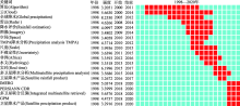
Fig. 7
Keywords burst detection of evaluation of satellite precipitation product"


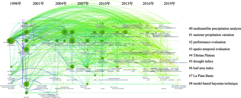
Fig. 8
Timeline view of co-occurrence keyword evaluation of satellite precipitation product"
Tab. 3
Cluster of keywords"
| 聚类编号 | 聚类内节点数 | 平均年份 | 聚类标签 |
|---|---|---|---|
| 0 | 64 | 2012 | west Africa; hydrolgical applications; several rainfall products; high-resolution gauge networks; Colorado flash flood; southeastern south America; using high-resolution numerical weather forecasts; springtime precipitation; using gauge observations | TRMM; drought monitoring; Jiangsu; China; precipitation data; uncertainty quantification; different seasons; spatial evaluation; global climate models; water vapor flux |
| 1 | 61 | 2012 | precipitation products; complex mountainous terrain; water resources perspective; Pakistan; precipitation; satellite-derived agro-climate variables; states; northern great plains; dynamic Bayesian model | China; Yellow River; reliability; gridded precipitation products; central Mediterranean; satellite-derived global precipitation estimates; spatial evaluation; dynamic Bayesian model; water resources perspective; precipitation datasets |
| 2 | 58 | 2007 | evaluation; complex mountainous terrain; precipitation products; water resources perspective; trend analysis; microwave estimates; rain estimation; using forward-adjusted advection; west Africa; extreme events | performance evaluation; seasonal signatures; hydrologic predictability; merged satellite rainfall products; evaluation; using rain gauge measurements; TRMM ground-validation radar-rain errors; complex mountainous terrain; precipitation products; water resources perspective |
| 3 | 56 | 2013 | evaluation; central Asia; precipitation data sets; benchmarking high-resolution global satellite rainfall products; radar; PERSIANN system; tropical rainfall; satellite-based estimates; Pakistan; algorithm | China; Yellow River; reliability; gridded precipitation products; assessment; mainland china; high-resolution satellite precipitation products; precipitation trends; analysing ground reference uncertainty; Australian snowpack |
| 4 | 50 | 2015 | evaluation; China; TRMM; hydrological application; NCEP-CFSR; precipitation estimates; humid regions; IMERG satellite precipitation products; ground-based data; correction | basin; hydrological evaluation; Ethiopia; air temperature datasets; using swat; open-access precipitation; reanalysis precipitation products; precipitation datasets; mountainous basins; multiple satellite precipitation products |
| 5 | 50 | 2012 | evaluation; China; TMPA satellite precipitation product; hydrologic validation; Pearl River; water balance perspective; evapotranspiration; machine learning techniques; sensitivity testing; considering global warming | drought indices; long-term satellite-based precipitation products; applicability; considering global warming; integration; mainland China; bottom-up satellite precipitation products; machine learning techniques; satellite soil moisture; downscaling |
| 6 | 40 | 2011 | evaluation; cloud; cloud-aerosol lidar; vertical structure; infrared pathfinder satellite observations; reanalyses; forest; evaluating PERSIANN-CCS; NOAA AVHRR satellite data | RHESSys model; climate change; watershed hydro-ecology; effects; Seolma-cheon catchment; forest; different spatial resolution; yield variability; plot; soybean crop coverage estimation |
| 7 | 33 | 2004 | cloud; atmospheric radiation measurement march; midlatitude; simulations; cloud-resolving models; frontal clouds; intensive operational period; precipitation data sets; observations; temperature | river discharges; air-sea fluxes; Danube; Bosphorus; black sea; focus; methods; products; reintroduction programmes |
| 8 | 11 | 2003 | evaluation; precipitation; real-time rainfall product; comparison; soil moisture; high-resolution tropical weather forecasts; storm scales; using MODIS gross primary productivity; millimeter-wave observations; gridded precipitation datasets | using MODIS gross primary productivity; vegetation activities; evapotranspiration products; climatological perspectives; Korean regional flux network site; evaluating ecohydrological impacts; millimeter-wave observations; west Africa; high-resolution tropical weather forecasts; storm scales |
| [1] | Xu R, Tian F Q, Yang L, et al. Ground validation of GPM IMERG and TRMM 3B42V7 rainfall products over southern Tibetan Plateau based on a high-density rain gauge network[J]. Journal of Geophysical Research: Atmospheres, 2017,122:1-15. |
| [2] | Zambrano-bigiarini M, Nauditt A, Birkel C. Temporal and spatial evaluation of satellite-based rainfall estimates across the complex topographical and climatic gradients of Chile[J]. Hydrology and Earth System Science, 2017,21:1295-1320. |
| [3] | Howat I M, Tulaczyk S, Rhodes P. A precipitation-dominated, mid-latitude glacier system: Mount Shasta, California[J]. Climate Dynamics, 2007,28(1):85-98. |
| [4] | Keller S, Atzl A. Mapping natural hazard impacts on road infrastructure: The extreme precipitation in Baden-Württemberg, Germany, June 2013[J]. International Journal of Disaster Risk Science, 2014,5(3):227-241. |
| [5] | Mo K L, Chen Q W, Chen C, et al. Spatiotemporal variation of correlation between vegetation cover and precipitation in an arid mountain-oasis river basin in northwest China[J]. Journal of Hydrology, 2019,574:138-147. |
| [6] | Hui-mean F, Yusop Z, Yusof F. Drought analysis and water resource availability using standardized precipitation evapotranspiration index[J]. Atmospheric Research, 2018,201:102-115. |
| [7] | Trenbrth K E, Smith L, Qian T, et al. Estimates of the global water budget and its annual cycle using observational and model data[J]. Journal of Hydrometeorology, 2007,8(4):758-769. |
| [8] | Skliris N, Marsh R, Josey S A, et al. Salinity changes in the world ocean since 1950 in relation to changing surface freshwater fluxes[J]. Climate Dynamics, 2014,43(3-4):709-736. |
| [9] | Zhang Y J, Duo L, Pang Y Z, et al. Modern pollen assemblages and their relationships to vegetation and climate in the Lhasa Valley, Tibetan Plateau, China[J]. Quaternary International, 2018,467(Part B):210-221. |
| [10] | 唐国强, 万玮, 曾子悦, 等. 全球降水测量(GPM)计划及其最新进展综述[J]. 遥感技术与应用, 2015,30(4):607-615. |
| [ Tang Guoqiang, Wan Wei, Zeng Ziyue, et al. An overview of the global precipitation measurement (gpm) mission and its latest development[J]. Remote Sensing Technology and Application, 2015,30(4):607-615. ] | |
| [11] | Baroentti A, Acquaotta F, Fratianni S. Rainfall variability from a dense rain gauge network in north-west Italy[J]. Climate Research, 2018,75(3):201-213. |
| [12] | Foehn A, Hernánez G A, Schaefli B, et al. Spatial interpolation of precipitation from multiple rain gauge networks and weather radar data for operational applications in Alpine catchments[J]. Journal of Hydrology, 2018,563:1092-1110. |
| [13] | Tang G Q, Behrangi A, Long D, et al. Accounting for spatiotemporal errors of gauges: A critical step to evaluate gridded precipitation products[J]. Journal of Hydrology, 2018,559:294-306. |
| [14] | Hou A Y, Kakar R K, Neeck S, et al. The global precipitation measurement mission[J]. Bulletin of the American Meteorological Society, 2014,95(5):701-722. |
| [15] | 马自强. 青藏高原地区卫星降水时空降尺度研究[D]. 杭州: 浙江大学, 2017. |
| [ Ma Ziqiang. Downscaling satellite-based precipitation estimates over the Qinghai-Tibetan Plateau at different temporal scales[D]. Hangzhou: Zhejiang University, 2017. ] | |
| [16] | Huffman G J, Adler R F, Bolvin D T, et al. The TRMM multi-satellite precipitation analysis (TMPA): Quasi-global, multiyear, combined-sensor precipitation estimates at fine scale[J]. Journal of Hydrometeorology, 2007,8(1):38-55. |
| [17] | Huffman G J, Adler R F, Arkin P, et al. Improving the global precipitation record: GPCP Version 2.1[J]. Geophysical Research Letters, 2009,36(17):153-159. |
| [18] | Kummerow C D, Barnes W, Kozu T, et al. The tropical rainfall measuring mission (TRMM) sensor package[J]. Journal Atmospheric Ocean Technology, 1998,15:809-917. |
| [19] | Tomoo U, Kazishi S, Takuji K, et al. A Kalman filter approach to the global satellite mapping of precipitation (GSMaP) from combined passive microwave and infrared radiometric data[J]. Journal of the Meteorological Society of Japan, 2009,87A:137-151. |
| [20] | Hong Y, Chen S, Xue X, et al. Multiscale hydrologic remote sensing: Perspectives and applications[M]. CRC Press, 2012, 371-386. |
| [21] |
Falags M E, Pitsouni E I, Malietzis G A, et al. Comparison of PubMed, Scopus, Web of Science, and Google Scholar: Strengths and weaknesses[J]. Faseb Journal, 2008,22(2):338-342.
doi: 10.1096/fj.07-9492LSF pmid: 17884971 |
| [22] | De Bakker F G A, Groenewegen P, Hond F D. A bibliometric analysis of 30 years of research and theory on corporate social responsibility and corporate social performance[J]. Business & Society, 2005,44(3):283-317. |
| [23] | 赵蓉英, 许丽敏. 文献计量学发展演进与研究前沿的知识图谱探析[J]. 中国图书馆学报, 2010(5):62-70. |
| [ Zhao Rongying, Xu Limin. The knowledge map of the evolution and research frontiers of bibiometrics[J]. Journal of Library Science in China, 2010(5):62-70. ] | |
| [24] | Chen C M. CiteSpace II: Detecting and visualizing emerging trends and transient patterns in scientific literature[J]. Journal of the American Society for Information Science and Technology, 2006,57(3):359-377. |
| [25] | Chen C M. Searching for intellectual turning points: Progressive knowledge domain visualization[J]. Proceedings of the National Academy of Sciences of the United States of America, 2004,101(Suppl. 1):5303-5310. |
| [26] | 陈悦, 陈超美, 刘则渊, 等. CiteSpace知识图谱的方法论功能[J]. 科学学研究, 2015. 33(2):242-253. |
| [ Chen Yue, Chen Chaomei, Liu Zeyuan, et al. The methodology function of CiteSpace mapping knowledge domains[J]. Studies in Science of Science, 2015,33(2):242-253. ] | |
| [27] | 李杰, 陈超美. CiteSpace: 科技文本挖掘及可视化[M]. 北京: 首都经济贸易大学出版社, 2016. |
| [ Li Jie, Chen Chaomei. CiteSpace: Text mining and visualization in scientific literature[M]. Beijing: Capital University of Economic and Business Press, 2016. ] | |
| [28] | White H, Mccain K. Visualizing a discipline: An author co-citation analysis of information science[J]. Journal of the Association for Information Science & Technology, 2010,49(4):327-355. |
| [29] | Nerini D, Zulkafli Z, Wang L P, et al. A comparative analysis of TRMM-rain gauge data merging techniques at the daily time scale for distributed rainfall-runoff modeling applications[J]. Journal of Hydrometeorology, 2015,16(5):2153-2168. |
| [30] | Munier S, Aires F, Schlaffer S, et al. Combining data sets of satellite-retrieved products for basin-scale water balance study: Evaluation on the Mississippi Basin and closure correction model[J]. Journal of Geophysical Research-Atmospheres, 2014,119(21):12100-12116. |
| [31] | Tan M L, Chua V P, Tan K C, et al. Evaluation of TMPA 3B43 and NCEP-CFSR precipitation products in drought monitoring over Singapore[J]. International Journal of Remote Sensing, 2018,39(8):2089-2104. |
| [32] | Tang G Q, Ma Y Z, Long D. Evaluation of GPM Day-1 IMERG and TMPA Version-7 legacy products over mainland China at multiple spatiotemporal scales[J]. Journal of Hydrology, 2016,533:152-167. |
| [33] | Ashouri H, Hsu K L, Sorooshian S, et al. PERSIANN-CDR: Daily precipitation climate data record from multisatellite observations for hydrological and climate studies[J]. Bulletin of the American Meteorological Society, 2015,96(1):69-83. |
| [34] | Dee D P, Uppala S M, Simmons A J, et al. The ERA-Interim reanalysis: Configuration and performance of the data assimilation system[J]. Quarterly Journal of the Royal Meteorological Society, 2011,137:553-597. |
| [35] | Behrangi A, Khakbaz B, Jaw T C, et al. Hydrologic evaluation of satellite precipitation products over a mid-size basin[J]. Journal of Hydrology, 2011,397(3-4):225-237. |
| [36] | Ebert E E, Janowiak J E, Kidd C. Comparison of near-real-time precipitation estimates from satellite observations and numerical models[J]. Bulletin of the American Meteorological Society, 2007,88(1):47-64. |
| [37] | Xue X, Hong Y, Limaye A S, et al. Statistical and hydrological evaluation of TRMM-based multi-satellite precipitation analysis over the Wangchu Basin of Bhutan: Are the latest satellite precipitation products 3B42V7 ready for use in ungauged basins?[J]. Journal of Hydrology, 2013,499:91-99. |
| [38] | Su F, Hong Y, Lettenmaier D P. Evaluation of TRMM multisatellite precipitation analysis (TMPA) and its utility in hydrologic prediction in the La Plata Basin[J]. Journal of Hydrometeorology, 2008,9(4):622-640. |
| [39] | Hirpa F A, Gebrebremichael M, Hopson O T. Evaluation of high-resolution satellite precipitation products over very complex terrain in Ethiopia[J]. Journal of Applied Meteorology & Climatology, 2010,49(5):1044-1051. |
| [40] | 王云, 马丽, 刘毅. 城镇化研究进展与趋势——基于CiteSpace和HistCite的图谱量化分析[J]. 地理科学进展, 2018,37(2):239-254. |
| [ Wang Yun, Ma Li, Liu Yi. Progress and trend analysis of urbanization research: Visualized quantitative study based on CiteSpace and HistCite[J]. Progress in Geography, 2018,37(2):239-254. ] | |
| [41] | 郭瑞芳, 刘元波. 多传感器联合反演高分辨率降水方法综述[J]. 地球科学进展, 2015,30(8):891-903. |
| [ Guo Ruifang, Liu Yuanbo. Multi-satellite retrieval of high resolution precipitation: An overview[J]. Advances in Earth Science, 2015,30(8):891-903. ] | |
| [42] | 唐国强, 龙笛, 万玮, 等. 全球水遥感技术及其应用研究的综述与展望[J]. 中国科学: 技术科学, 2015(45):1013-1023. |
| [ Tang Guoqiang, Long Di, Wan Wei, et al. An overview and outlook of global water remote sensing technology and applications[J]. Scienta Sinica Technology, 2015(45):1013-1023. ] | |
| [43] | 肖柳斯, 张阿思, 闵超, 等. GPM卫星降水产品在台风极端降水过程的误差评估[J]. 高原气象, 2019,38(5):993-1003. |
| [ Xiao Liusi, Zhang Asi, Min Chao, et al. Evaluation of GPM satellite-based precipitation estimates during three tropical-related extreme rainfall events[J]. Plateau Meteorology, 2019,38(5):993-1003. ] | |
| [44] | 廖荣伟, 张冬斌, 沈艳. 6种卫星降水产品在中国区域的精度特征评估[J]. 气象, 2015,41(8):970-979. |
| [ Liao Rongwei, Zhang Dongbin, Shen Yan. Validation of six satellite-derived rainfall estimates over China[J]. Meteorological Monthly, 2015,41(8):970-979. ] | |
| [45] | 潘旸, 宇婧婧, 廖捷, 等. 地面和卫星降水产品对台风莫拉克降水监测能力的对比分析[J]. 气象, 2011,37(5):564-570. |
| [ Pan Yang, Yu Jingjing, Liao Jie, et al, Assessment of the rainfall monitoring of Typhoon Morakot by ground-gauged and satellite precipitation products[J]. Meteorological Monthly, 2011,37(5):564-570. ] | |
| [46] | Argueso D, Di Luca A, Evans J P. Precipitation over urban areas in the western maritime continent using a convection-permitting model[J]. Climate Dynamics, 2016,47(3-4):1143-1159. |
| [47] | Tesfaye M, Botaj J, Sivakumar V, et al. Evaluation of regional climatic model simulated aerosol optical properties over South Africa using ground-based and satellite observations[J]. ISRN Atmospheric Sciences, 2013,237483, doi: 10.1155/2013/237483. |
| [48] | Zambrano F, Wardlow B, Tadesse T, et al. Evaluating satellite-derived long-term historical precipitation datasets for drought monitoring in Chile[C]// Remote Sensing for Agriculture, Ecosystems & Hydrology XVIII. International Society for Optics and Photonics, 2017, 26-42. |
| [49] | Sahoo A K, Sheffield J, Pan M, et al. Evaluation of the tropical rainfall measuring mission multi-satellite precipitation analysis (TMPA) for assessment of large-scale meteorological drought[J]. Remote Sensing of Environment, 2015,159:181-193. |
| [50] |
Ryo M, Valeriano O C S, Kanae S, et al. Temporal downscaling of daily gauged precipitation by application of a satellite product for flood simulation in a poorly gauged basin and its evaluation with multiple regression analysis[J]. Journal of Hydrometeorology, 2014,15(2):563-580.
doi: 10.1175/JHM-D-13-052.1 |
| [51] |
Peng B, Shi J, Ni-meister W, et al. Evaluation of TRMM multisatellite precipitation analysis (TMPA) products and their potential hydrological application at an arid and semiarid basin in China[J]. IEEE Journal of Selected Topics in Applied Earth Observations and Remote Sensing, 2014,7(9):3915-3930.
doi: 10.1109/JSTARS.2014.2320756 |
| [52] | Wang Z, Zhong R, Lai C, et al. Evaluation of the GPM IMERG satellite-based precipitation products and the hydrological utility[J]. Atmospheric Research, 2017,196:151-163. |
| [53] | Jiang S, Ren L, Hong Y, et al. Improvement of multi-satellite real-time precipitation products for ensemble streamflow simulation in a middle latitude basin in south China[J]. Water Resources Management, 2014,28(8):2259-2278. |
| [54] | Wei H, Li J, Liang T. Study on the estimation of precipitation resources for rainwater harvesting agriculture in semi-arid land of China[J]. Agricultural Water Management, 2005,71(1):33-45. |
| [55] | Kukal M S, Suat I. Spatial and temporal changes in maize and soybean grain yield, precipitation use efficiency, and crop water productivity in the U. S. great plains[J]. Transactions of the ASABE, 2017,60(4):1189-1208. |
|
||