Arid Land Geography ›› 2021, Vol. 44 ›› Issue (2): 400-408.doi: 10.12118/j.issn.1000–6060.2021.02.11
• Earth Surface Process • Previous Articles Next Articles
GENG Xiaoqing1( ),HU Zhaomin1,ZHAO Xia1,SHEN Haihua1,FANG Jingyun1,2
Received:2019-02-25
Revised:2019-05-29
Online:2021-03-25
Published:2021-04-14
GENG Xiaoqing,HU Zhaomin,ZHAO Xia,SHEN Haihua,FANG Jingyun. Three-decadal changes of lakes in Hulun Buir grasslands, Inner Mongolia[J].Arid Land Geography, 2021, 44(2): 400-408.

Fig. 1
Study area and altitudes"

Tab. 1
Error matrix"
| 实际类型 | 分类结果 | ||
|---|---|---|---|
| 非水体 | 水体 | 总和 | |
| 非水体 | 6078 | 46 | 6124 |
| 水体 | 388 | 3156 | 3544 |
| 总和 | 6466 | 3202 | 9668 |
| 总体精度=95.51%,K=90.13% | |||

Fig. 2
Lake distribution of the study area and the lake classification based on lake area"

Tab. 2
Statistics on the lake number and area change of Hulun Buir from 1986 to 2017"
| 区域 | 湖泊等级 | 湖泊数量/个 | 湖泊面积/km2 | 干涸湖泊数量/个 | 新增湖泊 数量/个 | 湖泊数量 净变化/个 | 湖泊数量变化百分比/% | 湖泊面积变化/km2 | 湖泊面积变化百分比/% | ||
|---|---|---|---|---|---|---|---|---|---|---|---|
| 1986—1990年 | 2014—2017年 | 1986—1990年 | 2014—2017年 | ||||||||
| 合计 | 小 | 60 | 46 | 41.8 | 27.9 | 19 | 5 | -14 | -23.3 | -13.9 | -33.3 |
| 中 | 62 | 57 | 130.4 | 134.4 | 5 | 0 | -5 | -8.1 | 4.0 | 3.1 | |
| 大 | 6 | 5 | 2243.6 | 2170.3 | 1 | 0 | -1 | -16.7 | -73.3 | -3.3 | |
| 陈巴尔虎旗 | 小 | 4 | 6 | 2.7 | 3.5 | 0 | 2 | 2 | 50.0 | 0.8 | 29.6 |
| 中 | 14 | 14 | 36.9 | 51.0 | 0 | 0 | 0 | 0.0 | 14.1 | 38.2 | |
| 大 | 1 | 1 | 18.4 | 18.0 | 0 | 0 | 0 | 0.0 | -0.4 | -2.2 | |
| 新巴尔虎右旗 | 小 | 23 | 14 | 16.0 | 7.3 | 10 | 1 | -9 | -39.1 | -8.7 | -54.4 |
| 中 | 14 | 10 | 34.6 | 15.3 | 4 | 0 | -4 | -28.6 | -19.3 | -55.8 | |
| 大 | 3 | 3 | 2151.5 | 2132.3 | 0 | 0 | 0 | 0.0 | -19.2 | -0.9 | |
| 新巴尔虎左旗 | 小 | 22 | 16 | 15.9 | 9.9 | 6 | 0 | -6 | -27.3 | -6.0 | -37.7 |
| 中 | 26 | 25 | 47.4 | 57.3 | 1 | 0 | -1 | -3.9 | 9.9 | 20.9 | |
| 大 | 2 | 1 | 73.7 | 20.1 | 1 | 0 | -1 | -50.0 | -53.6 | -72.7 | |
| 满洲里 | 小 | 1 | 1 | 0.5 | 0.5 | 1 | 1 | 0 | 0.0 | 0.0 | 0.0 |
| 中 | 0 | 0 | 0.0 | 0.0 | 0 | 0 | 0 | 0.0 | 0.0 | 0.0 | |
| 大 | 0 | 0 | 0.0 | 0.0 | 0 | 0 | 0 | 0.0 | 0.0 | 0.0 | |
| 海拉尔 | 小 | 2 | 1 | 1.6 | 1.0 | 1 | 0 | -1 | -50.0 | -0.6 | -37.5 |
| 中 | 0 | 0 | 0.0 | 0.0 | 0 | 0 | 0 | 0.0 | 0.0 | 0.0 | |
| 大 | 0 | 0 | 0.0 | 0.0 | 0 | 0 | 0 | 0.0 | 0.0 | 0.0 | |
| 鄂温克族自治区 | 小 | 8 | 8 | 5.1 | 5.7 | 1 | 1 | 0 | 0.0 | 0.6 | 11.8 |
| 中 | 8 | 8 | 11.4 | 10.8 | 0 | 0 | 0 | 0.0 | -0.6 | -5.3 | |
| 大 | 0 | 0 | 0.0 | 0.0 | 0 | 0 | 0 | 0.0 | 0.0 | 0.0 | |

Fig. 3
Changes in the number of lakes of various types and details of specific changes in the late 1980s and mid-2010s"


Fig. 4
Changes in the number and area of various types of lakes from 1986 to 2017"
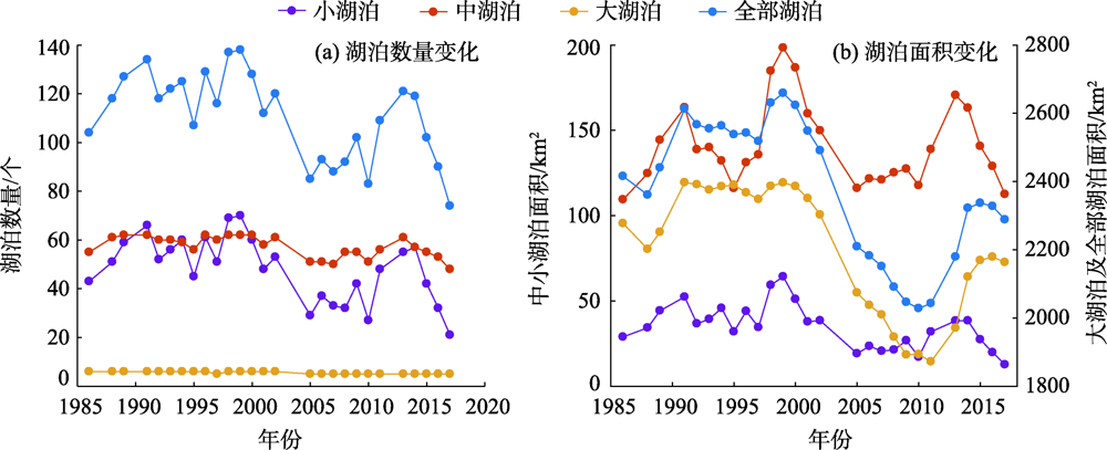
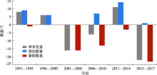
Fig. 5
Changes in the number of small and medium lakes in the study area every 5 years"

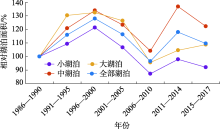
Fig. 6
Temporal changes in relative water area (RWA, in percent) for various types of lakes"

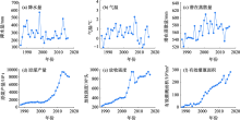
Fig. 7
Changes of climate and human activities in Hulun Buir from 1986 to 2017"

Tab. 3
Statistical analysis between lake area and climate change and human activity"
| 因素类型 | 小湖泊面积 | 中湖泊面积 | 大湖泊面积 | 总湖泊面积 | |||||||
|---|---|---|---|---|---|---|---|---|---|---|---|
| SS/% | r | SS/% | r | SS/% | r | SS/% | r | ||||
| 降水量 | 35.40** | 0.42* | 34.10* | 0.34 | 0.70 | 0.10 | 2.40 | 0.16 | |||
| 气温 | 0.04 | -0.06 | 2.60 | -0.14 | 14.30** | 0.23 | 11.30** | 0.19 | |||
| 潜在蒸散量 | 4.90 | -0.29 | 9.90 | -0.03 | 16.20** | -0.27 | 12.90** | -0.26 | |||
| 原煤产量 | 24.10** | -0.39 | 0.90 | -0.01 | 32.10** | -0.60** | 31.10** | -0.57** | |||
| 有效灌溉面积 | 31.20** | -0.63** | 38.50* | -0.17 | 29.10** | -0.79** | 33.50** | -0.77** | |||
| 放牧强度 | 1.40 | -0.67** | 3.80 | -0.27 | 6.70* | -0.81** | 6.80* | -0.80** | |||
| 残差 | 2.90 | 0.42* | 10.00 | 0.34 | 1.70 | 0.10 | 2.00 | 0.16 | |||
| [1] | 赵澍, 冀玮强, 高鹏, 等. 1986—2016年呼伦湖水域面积动态变化及与气候因素关系研究[J]. 中国农业资源与区划, 2018,39(4):53-58. |
| [ Zhao Shu, Ji Weiqiang, Gao Peng, et al. Study on dynamic change of Hulun Lake water area and the relationship with the climatic factors during 1986—2016[J]. Chinese Journal of Agricultural Resources and Regional Planning, 2018,39(4):53-58. ] | |
| [2] | Ma R H, Yang G H, Duan H T, et al. China’s lakes at present: Number, area and spatial distribution[J]. Science China-Earth Sciences, 2010,54(2):283-289. |
| [3] | Xie P, Chen Y Y. Threats to biodiversity in Chinese inland waters[J]. Ambio, 1999,28(8):674-681. |
| [4] | 张玉静, 杨秀春, 郭剑, 等. 呼伦贝尔草原物候变化及其与气象因子的关系[J]. 干旱区地理, 2019,42(1):144-153. |
| [ Zhang Yujing, Yang Xiuchun, Guo Jian, et al. Phenological variation and its relationship with meteorological factors in Hulun Buir grasslands[J]. Arid Land Geography, 2019,42(1):144-153. ] | |
| [5] | 封建民, 王涛. 呼伦贝尔草原沙漠化现状及历史演变研究[J]. 干旱区地理, 2004,27(3):356-360. |
| [ Feng Jianmin, Wang Tao. Study on the actualty and historical evolution of desertification in the Hulun Buir grasslands[J]. Arid Land Geography, 2004,27(3):356-360. ] | |
| [6] | 叶佳琦, 李政海, 乌云其其格, 等. 呼伦贝尔草原、湿地和森林植被对气候变化的响应[J]. 中国草地学报, 2018,40(6):26-32. |
| [ Ye Jiaqi, Li Zhenghai, Wu Yunqiqige, et al. The response of steppe, wetland and forest vegetation to climate change in Hulun Buir[J]. Chinese Journal of Grassland, 2018,40(6):26-32. ] | |
| [7] | Addison J, Friedel M, Brown C, et al. A critical review of degradation assumptions applied to Mongolia’s gobi desert[J]. Rangeland Journal, 2012,34(2):125-137. |
| [8] | 代海燕, 李丹, 娜日苏, 等. 内蒙古干湿环境演变与地区生态建设优势气候背景分析[J]. 干旱区地理, 2019,42(4):745-752. |
| [ Dai Haiyan, Li Dan, Na Risu, et al. Dry and wet environment evolution and climatic background analysis of regional ecological constrction in Inner Mongolia[J]. Arid Land Geography, 2019,42(4):745-752. ] | |
| [9] | Tao S L, Fang J Y, Zhao X, et al. Rapid loss of lakes on the Mongolian Plateau[J]. Proceedings of the National Academy of Sciences of the United States of America, 2015,112(7):2281-2286. |
| [10] | 杨会彩, 姜明媛, 阿噟兰, 等. 呼伦湖自然保护区土地利用及景观格局变化研究[J]. 北京师范大学学报(自然科学版), 2013,49(增刊1):318-325. |
| [ Yang Huicai, Jiang Mingyuan, A Yinglan, et al. Changes in land use and landspace pattern in Hulun Lake Nature Reserve[J]. Journal of Beijing Normal University (Natural Science), 2013,49(Suppl. 1):318-325. ] | |
| [11] | 褚永海, 李建成, 姜卫平, 等. 利用Jason-1数据监测呼伦湖水位变化[J]. 大地测量与地球动力学, 2005,25(4):11-16. |
| [ Chu Yonghai, Li Jiancheng, Jiang Weiping, et al. Monitoring of water level variations of Hulun Lake with Jason 1 altimertic data[J]. Journal of Geodest and Geodynamics, 2005,25(4):11-16. ] | |
| [12] | Li S, Chen J, Xiang J, et al. Water level changes of Hulun Lake in Inner Mongolia derived from Jason satellite data[J]. Journal of Visual Communication and Image Representation, 2019,58:565-575. |
| [13] | Hu S, Wang S, Appel E, et al. Environmental mechanism of magnetic susceptibility changes of lacustrine sediments from Lake Hulun, China[J]. Science in China Series D: Earth Sciences, 2000,43(5):534-540. |
| [14] | 赵慧颖, 乌力吉, 郝文俊. 气候变化对呼伦湖湿地及其周边地区生态环境演变的影响[J]. 生态学报, 2008,28(3):1064-1071. |
| [ Zhao Huiying, Wu Liji, Hao Wenjun. Influences of climate change to ecological and environmental evolvement in the Hulun Lake wetland and its surrounding areas[J]. Acta Ecologica Sinica, 2008,28(3):1064-1071. ] | |
| [15] | 任俊娴, 陈红兵, 柯杰, 等. 天然湿地在湖泊生态系统保护中的研究进展[J]. 湖南生态科学学报, 2018,5(1):52-57. |
| [ Ren Junxian, Chen Hongbing, Ke Jie, et al. Advance of natural wetlands in lake ecosystem protection[J]. Journal of Hunan Ecological Science, 2018,5(1):52-57. ] | |
| [16] | Jones S, Fremier A, Declerck F, et al. Big data and multiple methods for mapping small reservoirs: Comparing accuracies for applications in agricultural landscapes[J]. Remote Sensing, 2017,9(12):1307, doi: 10.3390/rs9121307. |
| [17] | Thornthwaite C W, Hare F K. Climatic classification in forest[J]. Unasylva, 1955,9(2):51-59. |
| [18] | 张新时. 植被的PE(可能蒸散)指标与植被-气候分类(二)——几种主要方法与PEP程序介绍[J]. 植物生态学与地植物学学报, 1989,13(3):197-207. |
| [ Zhang Xinshi. The potential evapotranspiration (PE) index for vegetation and vegetation-climatic classification(2): An introduction of main methods and PEP program[J]. Acta Phytoecologica et Geobotanica Sinica, 1989,13(3):197-207. ] | |
| [19] | Fang J Y, Yoda K. Climate and vegetation in China V. Effect of climatic factors on the upper limit of distribution of evergreen broadleaf forest[J]. Ecological Research, 1991,6(1):113-125. |
| [20] | 内蒙古自治区统计局. 内蒙古统计年鉴[M]. 北京: 中国统计出版社, 1986—2017. |
| [ Inner Mongolia Autonomous Region Statistics Bureau. Inner Mongolia statistical year book[M]. Beijing: China Statistics Press, 1986—2017. ] | |
| [21] | 程磊, 徐宗学, 左德鹏, 等. 基于Landsat TM数据的黄土高原区水体识别方法研究[J]. 北京师范大学学报(自然科学版), 2010,46(3):424-430. |
| [ Cheng Lei, Xu Zongxue, Zuo Depeng, et al. Identification of water bodies in the Loess Plateau based on Landsat TM dataset[J]. Journal of Beijing Normal University (Natural Science), 2010,46(3):424-430. ] | |
| [22] | MacFeeters S K. The use of normalized difference water index (NDWI) in the delineation of open water feature[J]. International Journal of Remote Sensing, 1995,17(7):1425-1432. |
| [23] | Fang J Y, Wang Z H, Zhao S Q, et al. Biodiversity changes in the lakes of the central Yangtze[J]. Frontiers in Ecology & the Environment, 2006,4(7):369-377. |
| [24] | 马超, 刘玮玮, 赵鹏飞, 等. 1962—2016年达里诺尔流域水、草退化及气候响应[J]. 地理研究, 2017,36(9):1755-1772. |
| [ Ma Chao, Liu Weiwei, Zhao Pengfei, et al. Wetland and grassland egradation and the response to climate in Dalinor Basin during 1962—2016[J]. Geographical Research, 2017,36(9):1755-1772. ] | |
| [25] | 中国科学院南京地理与湖泊研究所. 中国湖泊分布地图集[M]. 北京: 科学出版社, 2015. |
| [ Nanjing Institute of Geography & Limnology, Chinese Academy of Sciences. Chinese lake distribution atlas[M]. Beijing: Science Press, 2015. ] | |
| [26] | 牧寒. 内蒙古湖泊[M]. 呼和浩特: 内蒙古人民出版社, 2003. |
| [ Mu Han. Inner Mongolia lake[M]. Hohhot: Inner Mongolia People Publishing Press, 2003. ] | |
| [27] | 马秀芬, 翟立娟, 傅耀军, 等. 鄂尔多斯盆地煤炭基地含水层及其保护研究[J]. 中国煤炭地质, 2012,24(8):36-42. |
| [ Ma Xiufen, Zhai Lijuan, Fu Yaojun, et al. A study on aquifers and their protection in Ordos Basin coal base[J]. Coal Geology of China, 2012,24(8):36-42. ] | |
| [28] | 李强, 李永春, 陈大勇, 等. 神东矿区水资源可持续利用问题研究[J]. 干旱区资源与环境, 2013,27(9):141-147. |
| [ Li Qiang, Li Yongchun, Chen Dayong, et al. The water resource utilization in Shendong mining area[J]. Journal of Arid Land Resources and Environment, 2013,27(9):141-147. ] | |
| [29] | 王治良, 路春燕. 呼伦贝尔草原区土地利用及景观格局变化特征分析[J]. 干旱区资源与环境, 2015,29(12):91-97. |
| [ Wang Zhiliang, Lu Chunyan. Dynamic change of land use and landscape pattern in Hulun Buir grassland, China[J]. Journal of Arid Land Resources and Environment, 2015,29(12):91-97. ] | |
| [30] | 张德平. 内蒙古呼伦贝尔市土地利用现状及变化分析[J]. 中国土地科学, 2011,25(11):43-48. |
| [ Zhang Deping. Analysis on the current status and the changes of land use in Hulun Buir Inner Mongolia[J]. China Land Science, 2011,25(11):43-48. ] | |
| [31] | 张浩然, 清华, 刘华民, 等. 呼伦湖湖泊动态变化及其驱动力分析[J]. 内蒙古大学学报(自然科学版), 2018,49(1):102-107. |
| [ Zhang Haoran, Qing Hua, Liu Huamin, et al. Dynamics and its driving forces of Hulun Lake[J]. Journal of Inner Mongolia University (Natural Science Edition), 2018,49(1):102-107. ] | |
| [32] | Niu Z G, Zhang H Y, Wang X W, et al. Mapping wetland changes in China between 1978 and 2008[J]. Chinese Science Bulletin, 2012,57(22):2813-2823. |
| [1] | KANG Ligang, CAO Shengkui, CAO Guangchao, YAN Li, CHEN Lianxuan, LI Wenbin, ZHAO Haoran. Spatiotemporal variation of land surface temperature in Qinghai Lake Basin [J]. Arid Land Geography, 2023, 46(7): 1084-1097. |
| [2] | CHEN Mianwei, FENG Dan, ZHANG Shikai, JIANG Yu, ZHANG Xinlan. Dynamic monitoring and prediction of eco-environmental quality in Yining City based on RSEI and ANN-CA-Markov model [J]. Arid Land Geography, 2023, 46(6): 911-921. |
| [3] | CHEN Shujun,XU Guochang,LYU Zhiping,MA Mingyue,LI Hanyu,ZHU Yuyan. Spatiotemporal variations of fractional vegetation cover and its response to climate change and urbanization in China [J]. Arid Land Geography, 2023, 46(5): 742-752. |
| [4] | GAO Yanzhe, Alatengtuya , TAN Na, Aorigele . Lake changes and their influence factors in the Mongolian Plateau from 2000 to 2020 [J]. Arid Land Geography, 2023, 46(2): 191-200. |
| [5] | LIU Jingming, DING Jianli, BAO Qingling, ZHANG Zipeng, JIANG Leipeng, QU Yi. Characteristics of groundwater in Ebinur Lake Basin using isotopes method [J]. Arid Land Geography, 2023, 46(2): 201-210. |
| [6] | HAN Fei, LIU Tie, HUANG Yue, ZAN Chanjuan. Advance in the studies of responses of alpine lakes to climate change [J]. Arid Land Geography, 2023, 46(2): 233-242. |
| [7] | ZHAI Yuxin, ZHANG Feiyun, MA Lina. Evolution and prediction of habitat quality in the Bosten Lake Basin based on production-living-ecological space [J]. Arid Land Geography, 2023, 46(11): 1792-1802. |
| [8] | Yaxiaer AISIKEER, Yusufjiang RUSULI. Spatiotemporal variation characteristics and trend analysis of vegetation and water area in the Bosten Lake based on multiple endmember spectral mixture analysis model [J]. Arid Land Geography, 2023, 46(10): 1622-1631. |
| [9] | DING Yuekai, LIU Rui, ZHANG Cuilan, TONG Liyuan, DONG Jun. Remote sensing monitoring of glacier and glacial lake changes in Yairu Zangbo Basin, Himalayas [J]. Arid Land Geography, 2022, 45(6): 1870-1880. |
| [10] | Aierken TUERSUN,Yusufujiang RUSULI,CUI Yishuang,Kadiayi ALIMU,Miriayi MAITUDI. Temporal and spatial variations of lake ice phenology in large lakes of Xinjiang from 2000 to 2019 [J]. Arid Land Geography, 2022, 45(5): 1440-1449. |
| [11] | LI Yitong,RONG Lihua,LI Wenlong,CHENG Lei. Ecological security pattern at county level in northeast forest area of China from the perspective of ecological importance: A case of Arun Banner in Hulun Buir City [J]. Arid Land Geography, 2022, 45(5): 1615-1625. |
| [12] | XIE Liqian,E Chongyi,ZHAO Xia,LI Ping,ZHANG Jing,SUN Manping, Xianbaji. Pedogenesis process of residual parent material soil in the northeast Tibetan Plateau:Taking profile Ningxia in the north of Qinghai Lake as an example [J]. Arid Land Geography, 2022, 45(4): 1146-1154. |
| [13] | HAN Yanli,YU Deyong,CHEN Kelong,YANG Haizhen. Spatial distribution characteristics of temperature and precipitation trend in Qinghai Lake Basin from 2000 to 2018 [J]. Arid Land Geography, 2022, 45(4): 999-1009. |
| [14] | ZHAI Yongguang,ZHANG Xin,JI Honglan,MOU Xianyou,ZHANG Baosen. Ice-water classification in Inner Mongolia reach of the Yellow River based on remote sensing images [J]. Arid Land Geography, 2022, 45(3): 763-773. |
| [15] | XIANG Chaosheng,WANG Yong,WANG Junbo,MA Qingfeng,WANG Shihang. Environmental changes recorded by multiproxy of lake sediments in the high-altitude and arid area: A case of Lake Aksayqin [J]. Arid Land Geography, 2022, 45(2): 435-444. |
|
||