- May. 14, 2025
Arid Land Geography ›› 2022, Vol. 45 ›› Issue (3): 763-773.doi: 10.12118/j.issn.1000-6060.2021.347
• Hydrology and Water Resources • Previous Articles Next Articles
ZHAI Yongguang1( ),ZHANG Xin1,JI Honglan1(),MOU Xianyou1,ZHANG Baosen2
Received:2021-08-03
Revised:2021-10-10
Online:2022-05-25
Published:2022-05-31
Contact:
Honglan JI
E-mail:ychia@imau.edu.cn;honglanji@sina.com
ZHAI Yongguang,ZHANG Xin,JI Honglan,MOU Xianyou,ZHANG Baosen. Ice-water classification in Inner Mongolia reach of the Yellow River based on remote sensing images[J].Arid Land Geography, 2022, 45(3): 763-773.
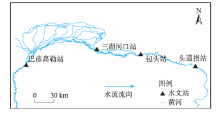
Fig. 1
Overview of the study area"
Tab. 1
Landsat 8 OLI remote sensing image information and atmospheric correction parameters"
| Landsat 8 OLI 影像条带号 | 日期 (年-月-日) | 平均大气柱 水汽量/g·cm-2 | 混合层高度/km | Landsat 8 OLI 影像条带号 | 日期 (年-月-日) | 平均大气柱 水汽量/g·cm-2 | 混合层高度/km |
|---|---|---|---|---|---|---|---|
| 129.032 | 2014-01-17 | 0.29 | 1.42 | 129.032 | 2017-02-26 | 0.22 | 2.19 |
| 128.032 | 2016-02-01 | 0.19 | 1.69 | 127.032 | 2018-02-15 | 0.12 | 2.23 |
| 128.032 | 2018-02-22 | 0.10 | 1.20 | 128.032 | 2018-02-06 | 0.19 | 2.20 |
| 130.032 | 2020-02-10 | 0.13 | 1.43 | 129.032 | 2018-02-13 | 0.17 | 2.23 |
| 128.032 | 2020-02-28 | 0.22 | 0.96 | 127.032 | 2019-01-17 | 0.10 | 2.19 |
| 127.032 | 2015-02-23 | 0.17 | 2.10 | 128.032 | 2019-01-24 | 0.26 | 2.13 |
| 128.032 | 2015-02-14 | 0.12 | 2.12 | 129.032 | 2019-02-16 | 0.28 | 2.22 |
| 129.032 | 2015-02-21 | 0.23 | 2.13 | 127.032 | 2020-02-21 | 0.22 | 2.13 |
| 127.032 | 2016-02-10 | 0.21 | 2.22 | 128.032 | 2020-02-12 | 0.14 | 2.13 |
| 128.032 | 2016-02-01 | 0.22 | 2.13 | 129.032 | 2020-02-19 | 0.22 | 2.22 |
| 129.032 | 2016-02-08 | 0.15 | 2.19 | 127.032 | 2021-01-22 | 0.29 | 2.22 |
| 127.032 | 2017-02-28 | 0.11 | 2.14 | 128.032 | 2021-01-29 | 0.29 | 2.19 |
| 128.032 | 2017-02-19 | 0.13 | 3.65 | 129.032 | 2021-02-21 | 0.23 | 2.13 |
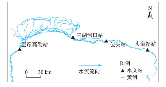
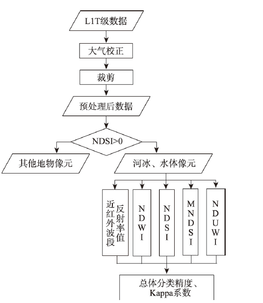
Fig. 2
Flowchart of image preprocessing and classification experiment"
Tab. 2
Confusion matrix of river ice and water body"
| 河冰真实值 | 水体真实值 | |
|---|---|---|
| 河冰预测值 | a11 | a12 |
| 水体预测值 | a21 | a22 |
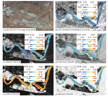
Fig. 3
Classification results of ice-water in five remote sensing models on February 1, 2016"


Fig. 4
Classification results of ice-water in five remote sensing models on February 22, 2018"

Tab. 3
Maximum (minimum) threshold range of the five remote sensing models"
| 阈值范围 | 近红外波段反射率值 | NDWI | NDUWI | NDSI | MNDSI |
|---|---|---|---|---|---|
| 最小 | 0~0.37 | 0~0.37 | 0~0.22 | 0~0.86 | -0.85~-0.05 |
| 最大 | 0~0.62 | 0~0.99 | 0~0.78 | 0~1.00 | -0.98~0 |
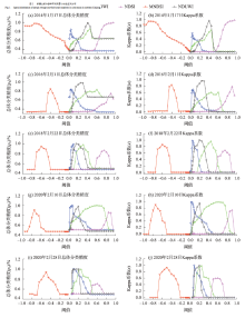
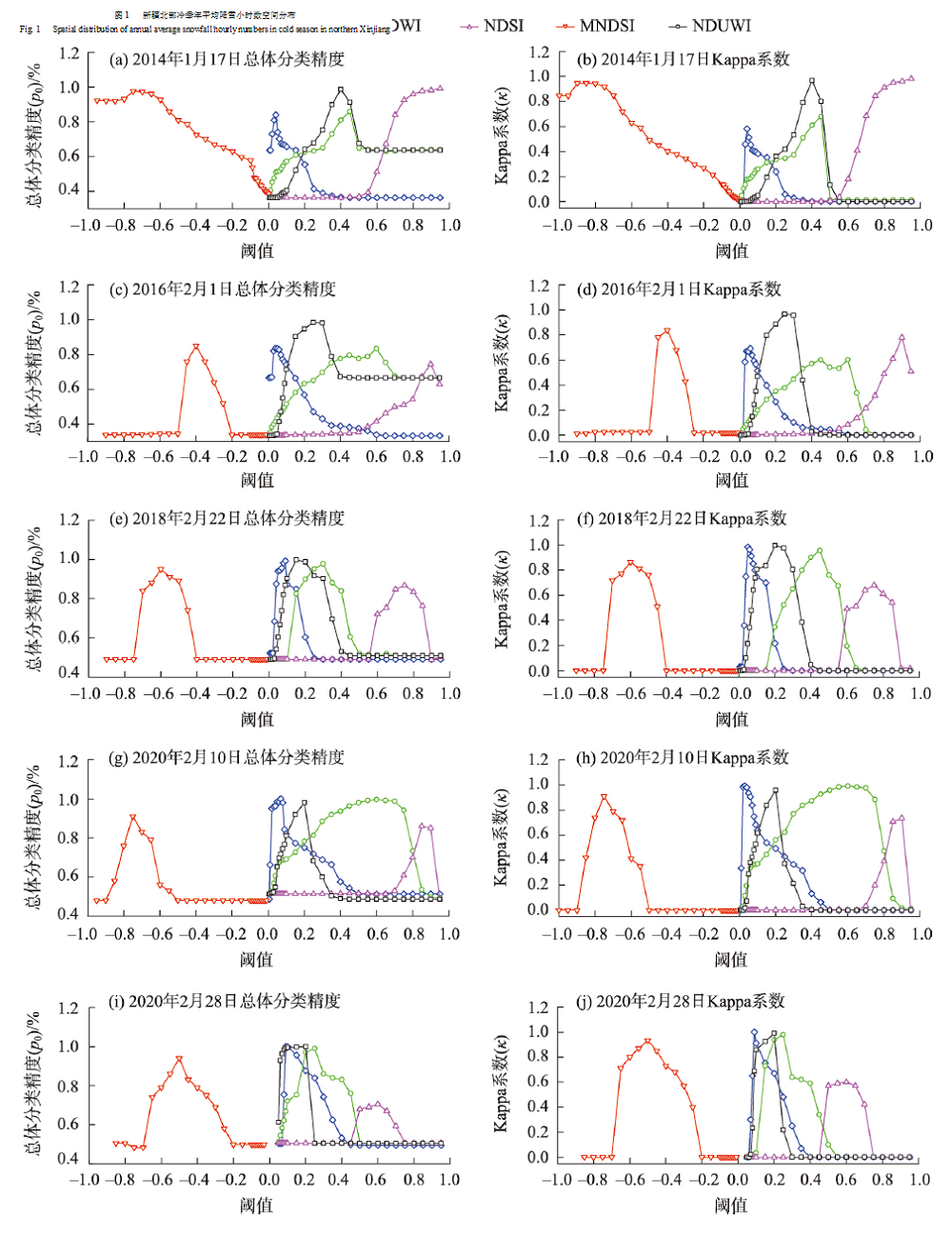
Fig. 5
Response of p0 and κ in the test area on the threshold"
Tab. 4
Highest classification accuracy of the remote sensing index models"
| 分类精度 | 近红外波段反射率值 | NDWI | NDUWI | NDSI | MNDSI |
|---|---|---|---|---|---|
| p0 /% | 99.12 | 98.25 | 99.89 | 98.34 | 99.21 |
| κ | 0.98 | 0.98 | 0.99 | 0.9 | 0.98 |
| [1] | 李超, 李畅游, 李红芳. 黄河(内蒙古段)弯道卡冰过程及数值模拟研究[J]. 水力发电学报, 2015, 34(10): 103-110. |
| [ Li Chao, Li Changyou, Li Hongfang. Study and simulation on ice jam process in river bends for Inner Mongolia reach of the Yellow River[J]. Journal of Hydroelectric Engineering, 2015, 34(10): 103-110. ] | |
| [2] | 高霈生, 靳国厚. 中国北方寒冷地区河冰灾害调查与分析[J]. 中国水利水电科学研究院学报, 2003, 1(2): 82-87. |
| [ Gao Peisheng, Jin Guohou. Investigation and analysis of river ice disaster in cold regions of North China[J]. Journal of China Institute of Water Resources and Hydropower Research, 2003, 1(2): 82-87. ] | |
| [3] | Jeffries M O, Morris K, Kozlenko N. Ice characteristics and processes, and remote sensing[J]. Remote Sensing in Northern Hydrology Measuring Environmental Change, 2005, 163: 63-90. |
| [4] | 李浩杰, 李弘毅, 王建, 等. 河冰遥感监测研究进展[J]. 地球科学进展, 2020, 35(10): 1041-1051. |
| [ Li Haojie, Li Hongyi, Wang Jian, et al. Advances in remote sensing of river ice[J]. Advances in Earth Science, 2020, 35(10): 1041-1051. ] | |
| [5] | 杨中华, 王卫东, 马浩录. “四星三源”模式监测黄河凌汛的研究与实践[J]. 科技导报, 2006(4): 64-67. |
| [ Yang Zhonghua, Wang Weidong, Ma Haolu. Monitoring ice flood of Yellow River with “four-satellite and three-resource” model[J]. Science & Technology Review, 2006(4): 64-67. ] | |
| [6] | 赵水霞, 李畅游, 李超, 等. 黄河什四份子弯道河冰生消及冰塞形成过程分析[J]. 水利学报, 2017, 48(3): 351-358. |
| [ Zhao Shuixia, Li Changyou, Li Chao, et al. Processes of river ice and ice-jam formation in Shensifenzi Bend of the Yellow River[J]. Journal of Hydraulic Engineering, 2017, 48(3): 351-358. ] | |
| [7] |
Chu T, Lindenschmidt K E. Integration of space-borne and air-borne data in monitoring river ice processes in the Slave River, Canada[J]. Remote Sensing of Environment, 2016, 181: 65-81.
doi: 10.1016/j.rse.2016.03.041 |
| [8] |
Chaouch N, Temimi M, Romanov P, et al. An automated algorithm for river ice monitoring over the Susquehanna River using the MODIS data[J]. Hydrological Processes, 2014, 28(1): 62-73.
doi: 10.1002/hyp.9548 |
| [9] | Dozier J. Spectral signature of alpine snow cover from the LANDSAT thematic mapper[J]. Remote Sensing of Environment, 1989, 45: 9-22. |
| [10] | 李志杰, 王宁练, 陈安安, 等. 1993-2016年喀喇昆仑山什约克流域冰川变化遥感监测[J]. 冰川冻土, 2019, 41(4): 770-782. |
| [ Li Zhijie, Wang Ninglian, Chen An’an, et al. Remote sensing monitoring of glacier changes in Shyok Basin of the Karakoram Mountains, 1993-2016 [J]. Journal of Glaciology and Geocryology , 2019, 41(4): 770-782. ] | |
| [11] |
高永鹏, 姚晓军, 刘时银, 等. 1956-2017年河西内流区冰川资源时空变化特征[J]. 冰川冻土, 2019, 41(6): 1313-1325.
doi: 10.7522/j.issn.1000-0240.2019.0054 |
|
[ Gao Yongpeng, Yao Xiaojun, Liu Shiyin, et al. Spatial-temporal variation of glacier resources in the Hexi interior from 1956 to 2017[J]. Journal of Glaciology and Geocryology, 2019, 41(6): 1313-1325. ]
doi: 10.7522/j.issn.1000-0240.2019.0054 |
|
| [12] |
姚晓军, 李龙, 赵军, 等. 近10年来可可西里地区主要湖泊冰情时空变化[J]. 地理学报, 2015, 70(7): 1114-1124.
doi: 10.11821/dlxb201507008 |
|
[ Yao Xiaojun, Li Long, Zhao Jun, et al. Spatial-temporal variations of lake ice in the Hoh Xil region from 2000 to 2011[J]. Acta Geographica Sinica, 2015, 70(7): 1114-1124. ]
doi: 10.11821/dlxb201507008 |
|
| [13] | 陈鹏, 王勇, 张青, 等. 基于FY-3D/MERSI-Ⅱ归一化积雪指数和MOD10A1的精度对比分析[J]. 干旱区地理, 2020, 43(2): 434-439. |
| [ Chen Peng, Wang Yong, Zhang Qing, et al. Comparison of the accuracy of normalized snow cover indices between FY-3D/MERSI-II and MODIS[J]. Arid Land Geography, 2020, 43(2): 434-439. ] | |
| [14] |
Li H J, Li H Y, Wang J, et al. Monitoring high-altitude river ice distribution at the basin scale in the northeastern Tibetan Plateau from a Landsat time-series spanning 1999-2018[J]. Remote Sensing of Environment, 2020, 247: 111915, doi: 10.1016/j.rse.2020. 111915.
doi: 10.1016/j.rse.2020. 111915 |
| [15] |
牟献友, 宝山童, 张宝森, 等. 基于遥感影像分析的1989-2019年黄河内蒙古段河冰时空变化[J]. 冰川冻土, doi: 10.7522/j. issn.1000-0240.2020.0058.
doi: 10.7522/j. issn.1000-0240.2020.0058 |
|
Mou Xianyou, Bao Shantong, Zhang Baosen, et al. A satellite-based analysis on spatial-temporal distribution and variation of river ice in Inner Mongolia reach from 1989 to 2019 based on remote sensing image interpretation [J]. Journal of Glaciology and Geocryology, doi: 10.7522/j.issn.1000-0240.2020.0058. ]
doi: 10.7522/j. issn.1000-0240.2020.0058 |
|
| [16] |
勾鹏, 叶庆华, 魏秋方. 2000-2013年西藏纳木错湖冰变化及其影响因素[J]. 地理科学进展, 2015, 34(10): 1241-1249.
doi: 10.18306/dlkxjz.2015.10.004 |
|
[ Gou Peng, Ye Qinghua, Wei Qiufang.Lake ice change at the Nam Co Lake on the Tibetan Plateau during 2000-2013 and influencing factors[J]. Progress in Geography, 2015, 34(10): 1241-1249. ]
doi: 10.18306/dlkxjz.2015.10.004 |
|
| [17] | 全栋, 李超, 路新川, 等. 黄河干流头道拐河段凌汛期小流量过程变化及其影响因素研究[J]. 冰川冻土, 2020, 42(2): 620-628. |
| [ Quan Dong, Li Chao, Lu Xinchuan, et al. A study of low discharge process and impacting factors of Toudaoguai reach in Inner Mongolia of the Yellow River during ice flood period[J]. Journal of Glaciology and Geocryology, 2020, 42(2): 620-628. ] | |
| [18] | 罗红春, 冀鸿兰, 郜国明, 等. 黄河什四份子弯道冰期水流及冰塞特征研究[J]. 水利学报, 2020, 51(9): 1089-1100. |
| [ Luo Hongchun, Ji Honglan, Gao Guoming, et al. Study on the characteristics of flow and ice jam in Shisifenzi bend in the Yellow River during the freeze-up period[J]. Journal of Hydraulic Engineering, 2020, 51(9): 1089-1100. ] | |
| [19] | 胡一三. 黄河宁夏内蒙古河段河道整治[J]. 水利规划与设计, 2010(5): 1-4. |
| [ Hu Yisan. River regulation of the Inner Mongolia reach of the Yellow River in Ningxia[J]. Water Resources Planning and Design, 2010(5): 1-4. ] | |
| [20] |
McFeeters S K. The use of the normalized difference water index (NDWI) in the delineation of open water features[J]. International Journal of Remote Sensing, 1996, 17(7): 1425-1432.
doi: 10.1080/01431169608948714 |
| [21] |
Hall D K, Riggs G A, Salomonson V V, et al. MODIS snow-cover products[J]. Remote Sensing of Environment, 2002, 83(1-2): 181-194.
doi: 10.1016/S0034-4257(02)00095-0 |
| [22] | 徐涵秋. 利用改进的归一化差异水体指数(MNDWI)提取水体信息的研究[J]. 遥感学报, 2005, 9(5): 589-595. |
| [ Xu Hanqiu. A study on information extraction of water body with the modified normalized difference water index (MNDWI)[J]. Journal of Remote Sensing, 2005, 9(5): 589-595. ] | |
| [23] |
Ouma Y O, Tateishi R. A water index for rapid mapping of shoreline changes of five east African Rift Valley lakes: An empirical analysis using Landsat TM and ETM+ data[J]. International Journal of Remote Sensing, 2006, 27(15): 3153-3181.
doi: 10.1080/01431160500309934 |
| [24] |
Landis J R, Koch G G. The measurement of observer agreement for categorical data[J]. Biometrics, 1977, 33(1): 159-174.
pmid: 843571 |
| [25] | Claude C R, Bernier M, Gauthier Y, et al. Remote sensing of lake and river ice[J]. Remote Sensing of the Cryosphere, 2015, 12: 273-306. |
| [26] | 李超. 黄河(内蒙古段)河冰生消演变特性及数值模拟研究[D]. 呼和浩特: 内蒙古农业大学, 2015. |
| [ Li Chao. Study on characteristics river ice evolution and numerical simulation of the Yellow River (Inner Mongolia reach)[D]. Hohhot: Inner Mongolia Agricultural University, 2015. ] | |
| [27] | 田园, 张雪芹, 孙瑞. 基于多源、 多时相遥感影像的高原湖泊提取及其不确定性--以西藏羊卓雍错流域为例[J]. 冰川冻土, 2012, 34(3): 563-572. |
| [ Tian Yuan, Zhang Xueqin, Sun Rui. Extracting alpine lake information based on multi-source and multi-temporal satellite images and its uncertainty analysis: A case study in Yamzhog Yumco Basin, south Tibet[J]. Journal of Glaciology and Geocryology, 2012, 34(3): 563-572. ] | |
| [28] |
Jonsson P, Eklundh L. Seasonality extraction by function fitting to time-series of satellite sensor data[J]. IEEE Transactions on Geoscience and Remote Sensing, 2002, 40(8): 1824-1832.
doi: 10.1109/TGRS.2002.802519 |
| [29] |
Medina C, Gomez-Enri J, Alonso J, et al. Water volume variations in Lake Izabal (Guatemala) from in situ measurements and ENVISAT radar altimeter (RA-2) and advanced synthetic aperture radar (ASAR) data products[J]. Journal of Hydrology, 2010, 382(1-4): 34-48.
doi: 10.1016/j.jhydrol.2009.12.016 |
| [30] | 秦启勇, 李雪梅, 张博, 等. 2000-2019年赛里木湖湖冰物候特征变化[J/OL]. 干旱区地理. [2021-09-26]. . |
| Qin Qiyong, Li Xuemei, Zhang Bo, et al. Change of ice phenology in the Sayram Lake from 2000 to 2019[J/OL]. Arid Land Geography. [2021-09-26]. . ] | |
| [31] | 高永鹏, 姚晓军, 刘时银, 等. 冰川冰储量计算方法及发展趋势[J]. 干旱区地理, 2018, 41(6): 1204-1213. |
| [ Gao Yongpeng, Yao Xiaojun, Liu Shiyin, et al. Methods and future trend of ice volume calculation of glacier[J]. Arid Land Geography, 2018, 41(6): 1204-1213. ] | |
| [32] | 庞毓雯, 黄雨馨, 巩志, 等. 基于多光谱遥感的湖冰物候监测方法研究进展[J]. 海洋湖沼通报, 2020(2): 90-99. |
| [ Pang Yuwen, Huang Yuxin, Gong Zhi, et al. Advances in phenological monitoring of lake ice based on multi-spectral remote sensing[J]. Transactions of Oceanology and Limnology, 2020(2): 90-99. ] | |
| [33] | 魏秋方, 叶庆华. 湖冰遥感监测方法综述[J]. 地理科学进展, 2010, 29(7): 803-810. |
| [ Wei Qiufang, Ye Qinghua. Review of lake ice monitoring by remote sensing[J]. Progress in Geography, 2010, 29(7): 803-810. ] | |
| [34] | Ulaby F T, Moore R K, Fung A K. Microwave remote sensing of alpine snow[J]. Institute of Electrical and Electronics Engineering, 2007, 12(7): 1223-1227. |
| [35] | 许健, 王掌权, 任建威, 等. 原状黄土冻融过程渗透特性试验研究[J]. 水利学报, 2016, 47(9): 1208-1217. |
| [ Xu Jian, Wang Zhangquan, Ren Jianwei, et al. Experimental research on permeability of undisturbed loess during the freeze-thaw process[J]. Journal of Hydraulic Engineering, 2016, 47(9): 1208-1217. ] | |
| [36] | 王延贵, 匡尚富. 河岸崩塌类型与崩塌模式的研究[J]. 泥沙研究, 2014, 12(1): 13-20. |
| [ Wang Yangui, Kuang Shangfu. Study of types and collapse modes of bank failures[J]. Journal of Sediment Research, 2014, 12(1): 13-20. ] | |
| [37] | 可素娟, 吕光圻, 任志远. 黄河巴彦高勒河段冰塞机理研究[J]. 水利学报, 2000(7): 66-69. |
| [ Ke Sujuan, Lü Guangyin, Ren Zhiyuan. Study on mechanism of ice jam formation in Bayangaole section of Yellow River[J]. Journal of Hydraulic Engineering, 2000(7): 66-69. ] | |
| [38] | 秦毅, 张晓芳, 王凤龙, 等. 黄河内蒙古河段冲淤演变及其影响因素[J]. 地理学报, 2011, 66(3): 324-330. |
| [ Qin Yi, Zhang Xiaofang, Wang Fenglong, et al. Scour and silting evolution and its influencing factors in Inner Mongolia reach[J]. Acta Geographica Sinica, 2011, 66(3): 324-330. ] | |
| [39] | 康玲玲, 王云璋, 陈发中, 等. 黄河上游宁蒙河段气温变化对凌情影响的分析[J]. 冰川冻土, 2001, 23(3): 318-322. |
| [ Kang Lingling, Wang Yunzhang, Chen Fazhong, et al. Analysis on effect of air temperature on ice jam floods at Ningmeng reaches of the Yellow River[J]. Journal of Glaciology and Geocryology, 2001, 23(3): 318-322. ] | |
| [40] |
Kropáček J, Maussion F, Chen F, et al. Analysis of ice phenology of lakes on the Tibetan Plateau from MODIS data[J]. The Cryosphere, 2013, 7(1): 287-301.
doi: 10.5194/tc-7-287-2013 |
| [1] | HAN Rucun,ZHANG Ying,LI Zhanling. Effects of two uncertainty sources on drought index of SPEI and on drought assessment [J]. Arid Land Geography, 2022, 45(5): 1392-1401. |
| [2] | DU Yu-zhang, JIANG Xiao-guang, ZHANG Yu-ze, HUANG Cheng, LIU Zhao-xia, LIU Liang. Retrieving leaf area index using PROSAIL radiative transfer model based on Landsat 8 image [J]. , 2016, 39(5): 1096-1103. |
| [3] | ZHAO Jie, XU Chang-chun, GAO Shen-tong, LI Jia-xiu. Hydrological modeling in the Urumqi River basin based on SWAT [J]. , 2015, 38(4): 666-674. |
| [4] | NIE Si-yu,MO Shu-hong,WANG Xue-feng,SHEN Bing. Method of simulation and uncertainty analysis for urban water demand [J]. , 2015, 38(2): 260-266. |
| [5] | ZHU Xu-chao,YUAN Guo-fu,YI Xiao-bo,DU Tao. Leaf area index inversion of riparian forest in the lower basin of Tarim River based on Landsat 8 OLI images [J]. , 2014, 37(6): 1248-1256. |
| Viewed | ||||||||||||||||||||||||||||||||||||||||||||||||||
|
Full text 576
|
|
|||||||||||||||||||||||||||||||||||||||||||||||||
|
Abstract 489
|
|
|||||||||||||||||||||||||||||||||||||||||||||||||
Cited |
|
|||||||||||||||||||||||||||||||||||||||||||||||||
| Shared | ||||||||||||||||||||||||||||||||||||||||||||||||||
|
||