Arid Land Geography ›› 2026, Vol. 49 ›› Issue (7): 1405-1417.doi: 10.12118/j.issn.1000-6060.2025.573
• Land Use and Ecosystem • Previous Articles Next Articles
YAN Yan1( ), LIU Yulu1,2(), ZHANG Weige1, SUN Qian1, ZHU Shihua3
Received:2025-09-19
Revised:2025-11-26
Online:2026-07-25
Published:2026-07-07
Contact:
LIU Yulu
E-mail:yanyan@lynu.edu.cn;liuyuluuuu@163.com
YAN Yan, LIU Yulu, ZHANG Weige, SUN Qian, ZHU Shihua. Accuracy evaluation and consistency analysis of multi-source land cover products in the arid regions of northwest China[J].Arid Land Geography, 2026, 49(7): 1405-1417.
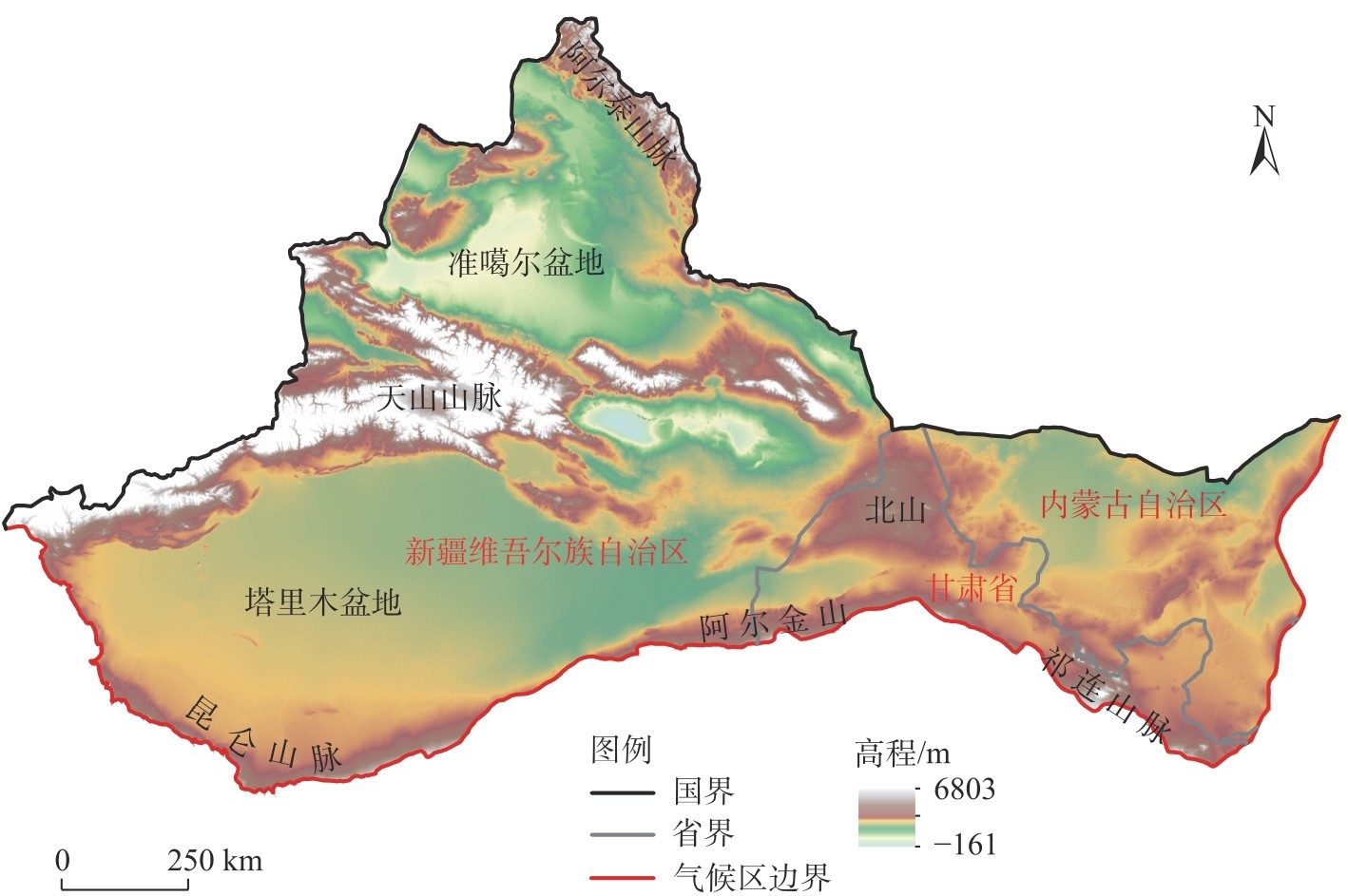
Fig. 1
Schematic diagram of the study area"

Tab. 1
Main parameters of land cover products"
| 数据名称 | 研发机构 | 空间分辨率/m | 分类数量/个 | 分类方法 | 总体 精度/% | 数据来源网址 |
|---|---|---|---|---|---|---|
| ESA全球10 m土地覆盖产品(ESA10) | 欧洲航天局(ESA) | 10 | 11 | 决策树分类 | 74.40 | https://viewer.esa-worldcover.org/worldcover |
| ESRI全球10 m土地覆盖产品(ESRI10) | 易智瑞公司 | 10 | 9 | 深度学习 | 85.96 | https://livingatlas.arcgis.com/landcover |
| 全球30 m土地覆盖产品(Globeland30) | 国家基础地理信息中心 | 30 | 10 | Pixel-Object-Knowledge(POK)法 | 85.72 | https://www.geodata.cn |
| 全球30 m细分类土地覆盖产品(GLC_FCS30) | 中国科学院 | 30 | 30 | 随机森林 | 72.27 | https://zenodo.org/record/3986872 |
| 中国年度30 m土地覆盖产品(CLCD) | 武汉大学 | 30 | 9 | 随机森林 | 79.31 | https://zenodo.org/record/5816591 |
Tab. 2
Classification system of the five sets of land cover products"
| ESA10 | ESRI10 | Globeland30 | GLC_FCS30 | CLCD | ||||||||||||||
|---|---|---|---|---|---|---|---|---|---|---|---|---|---|---|---|---|---|---|
| 代码 | 名称 | 土地覆盖类型说明 | 代码 | 名称 | 土地覆盖类型说明 | 代码 | 名称 | 土地覆盖类型说明 | 代码 | 名称 | 代码 | 名称 | 代码 | 名称 | ||||
| 10 | 林地 | 任何树木占主导地位的地理区域,覆盖率≥10%的地区 | 1 | 水域 | 全年水体覆盖区域(不含间歇/短暂水域),无稀疏植被、裸露岩石及建筑(如码头) | 10 | 耕地 | 用于种植农作物的土地 | 10 | 雨养耕地 | 121 | 常绿灌木丛 | 1 | 农田 | ||||
| 20 | 灌丛 | 包括任何以天然灌木为主、覆盖面积≥10%的地理区域 | 2 | 林地 | 任何显著、高大茂密植被聚集的地理区域 | 20 | 林地 | 乔木覆盖且树冠盖度≥30%的土地 | 11 | 草本农田 | 122 | 落叶灌木林 | 2 | 林地 | ||||
| 30 | 草地 | 天然草本植物为主且覆盖度≥10%的地区 | 4 | 淹没植被 | 植被与水混合的区域,植被包含灌、草 | 30 | 草地 | 天然草本植被覆盖,且盖度≥10%的土地 | 12 | 树本农田 | 130 | 草原 | 3 | 灌木 | ||||
| 40 | 农田 | 在播种/种植后的12个月内,已播种/种植并可收获至少一次的一年生农田覆盖土地 | 5 | 耕地 | 人工种植谷物、草本及作物(米、小麦、大豆)的结构化休耕地 | 40 | 灌木林地 | 灌木覆盖且灌丛覆盖度≥30%的土地 | 20 | 灌溉农田 | 140 | 地衣和苔藓 | 4 | 牧草地 | ||||
| 50 | 建设用地 | 被建筑物、道路和其他人造建筑(如铁路)覆盖的土地 | 7 | 建设用地 | 人造构筑物、主次道路铁路网、大面积均质不透水面 | 50 | 湿地 | 位于陆地和水域的交界带,有浅层积水或土壤过湿的土地,多生长有沼生或湿生植物 | 51 | 开阔常绿阔叶林 | 150 | 稀疏植被(fc<0.15) | 5 | 水域 | ||||
| 60 | 裸地 | 土壤、沙子或岩石等一年中任何时候植被覆盖率<10%的地区 | 8 | 裸地 | 全年植被稀疏或无植被覆盖的岩/土区域、少/无植被沙地及沙漠 | 60 | 水体 | 陆地范围液态水覆盖的区域 | 52 | 郁闭常绿阔叶林 | 152 | 稀疏灌丛(fc<0.15) | 6 | 雪/冰 | ||||
| 70 | 冰雪 | 被雪或冰川覆盖的地理区域 | 9 | 雪/冰 | 大面积均质永久冰雪区,多分布于山区或高纬度地区 | 70 | 苔原 | 寒带及高山环境下由地衣、苔藓、多年生耐寒草本和灌木植被覆盖的土地 | 61 | 开阔落叶阔叶林(0.15<fc<0.4) | 153 | 稀疏草本(fc<0.15) | 7 | 裸地 | ||||
| 80 | 永久水体 | 一年中超过9个月的时间被水体覆盖的地理区域 | 10 | 云 | 持续被云层覆盖的无地表覆盖信息区域 | 80 | 人造 地表 | 由人工建造活动形成的地表 | 62 | 郁闭落叶阔叶林(fc>0.4) | 180 | 湿地 | 8 | 不透 水面 | ||||
| 90 | 草本湿地 | 天然草本为主(覆盖≥10%),长期/定期被淡/微咸/咸水淹没;不含无植被沉积物、沼泽森林及红树林 | 11 | 牧场 | 开阔均质草本区,几乎无高大植被,非人工种植区域 | 90 | 裸地 | fc<10%的自然覆盖土地 | 71 | 开阔常绿针叶林(0.15<fc<0.4) | 190 | 不透水面 | 9 | 湿地 | ||||
| 95 | 红树林 | 耐盐树木及其他植物,分布于热带保护海岸潮间带、岛屿及河口地区 | 100 | 永久冰雪 | 由永久积雪、冰川和冰盖覆盖的土地 | 72 | 郁闭常绿针叶林(fc>0.4) | 200 | 裸地 | |||||||||
| 100 | 苔藓和地衣 | 覆盖地衣、苔藓的土地 | 81 | 开阔落叶针叶林(0.15<fc<0.4) | 201 | 硬质裸地 | ||||||||||||
| 82 | 郁闭落叶针叶林(fc>0.4) | 202 | 沙质裸地 | |||||||||||||||
| 91 | 开阔混交叶林(阔叶和针叶) | 210 | 水体 | |||||||||||||||
| 92 | 郁闭混交叶林(阔叶和针叶) | 220 | 永久冰雪 | |||||||||||||||
| 120 | 灌木丛 | 250 | 填充值 | |||||||||||||||
Tab. 3
Correspondence of land cover types between the original classification system and the new classification system"
| 代码 | 土地覆盖类型 | ESA10 | ESRI10 | Globeland30 | GLC_FCS30 | CLCD |
|---|---|---|---|---|---|---|
| 1 | 耕地 | 40 | 5 | 10 | 10、11、20 | 1 |
| 2 | 林地 | 10、20 | 2 | 20、40 | 51~92、120~122、152 | 2、3 |
| 3 | 草地 | 30、100 | 11 | 30 | 130、140、150、153 | 4 |
| 4 | 水域 | 80 | 1 | 60 | 210 | 5 |
| 5 | 冰雪 | 70 | 9 | 100 | 220 | 6 |
| 6 | 裸地 | 60 | 8 | 90 | 200~202 | 7 |
| 7 | 建设用地 | 50 | 7 | 80 | 190 | 8 |
| 8 | 湿地 | 90 | 4 | 50 | 180 | 9 |
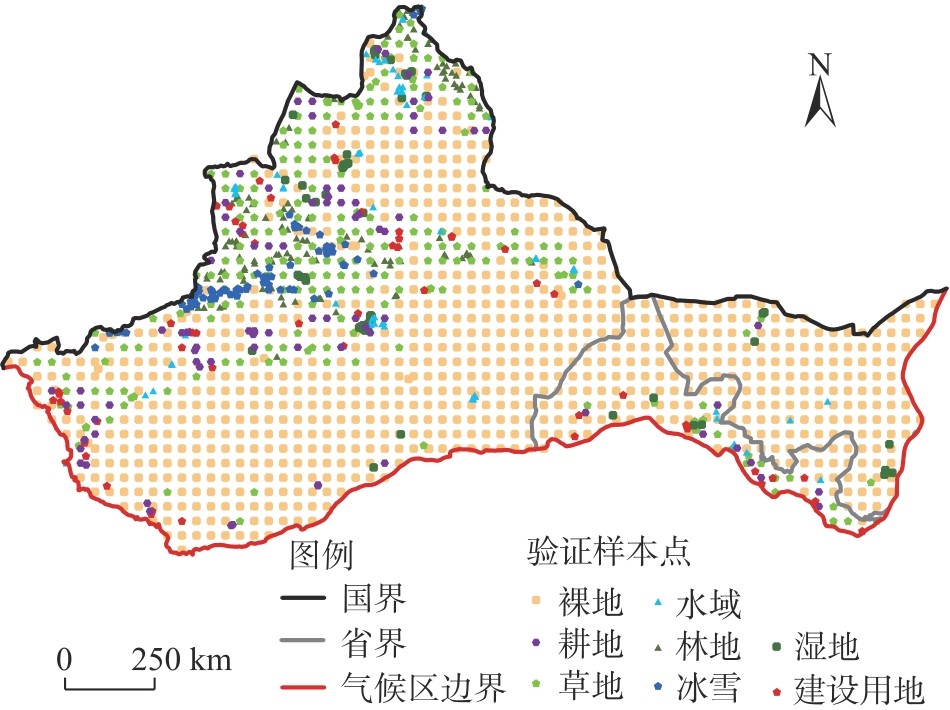
Fig. 2
Distribution of sample points for accuracy validation"
Tab. 4
Reference accuracy of the five sets of land cover products"
| 土地覆盖类型 | ESA10 | ESRI10 | Globeland30 | GLC_FCS30 | CLCD | |||||||||
|---|---|---|---|---|---|---|---|---|---|---|---|---|---|---|
| 用户精度/% | 生产者精度/% | 用户精度/% | 生产者精度/% | 用户精度/% | 生产者精度/% | 用户精度/% | 生产者精度/% | 用户精度/% | 生产者精度/% | |||||
| 耕地 | 91.94 | 67.86 | 77.01 | 79.76 | 70.75 | 89.29 | 55.07 | 90.48 | 48.17 | 94.05 | ||||
| 林地 | 83.80 | 96.75 | 98.84 | 69.11 | 86.67 | 63.41 | 68.21 | 95.93 | 90.57 | 78.05 | ||||
| 草地 | 86.45 | 59.03 | 33.50 | 88.65 | 63.03 | 78.85 | 57.20 | 59.47 | 63.79 | 84.58 | ||||
| 水域 | 83.54 | 100.00 | 87.32 | 93.94 | 85.07 | 86.36 | 100.00 | 78.79 | 94.92 | 84.85 | ||||
| 冰雪 | 89.87 | 89.87 | 95.71 | 84.81 | 97.01 | 82.28 | 90.48 | 96.20 | 93.06 | 84.81 | ||||
| 裸地 | 92.86 | 96.64 | 96.76 | 60.91 | 95.50 | 94.00 | 96.78 | 90.17 | 96.23 | 94.84 | ||||
| 建设用地 | 81.67 | 89.09 | 75.44 | 78.18 | 75.00 | 65.45 | 79.55 | 63.64 | 68.75 | 20.00 | ||||
| 湿地 | 70.71 | 92.11 | 93.18 | 53.95 | 90.16 | 72.37 | 76.92 | 39.47 | 100.00 | 5.26 | ||||
| 总体精度/% | 88.86 | 69.69 | 86.08 | 82.51 | 83.94 | |||||||||
| Kappa系数 | 0.83 | 0.59 | 0.79 | 0.75 | 0.76 | |||||||||
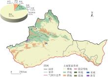
Fig. 3
Spatial distribution of land cover and the area proportion of each type in the arid regions of northwest China in 2020 based on ESA10 product"
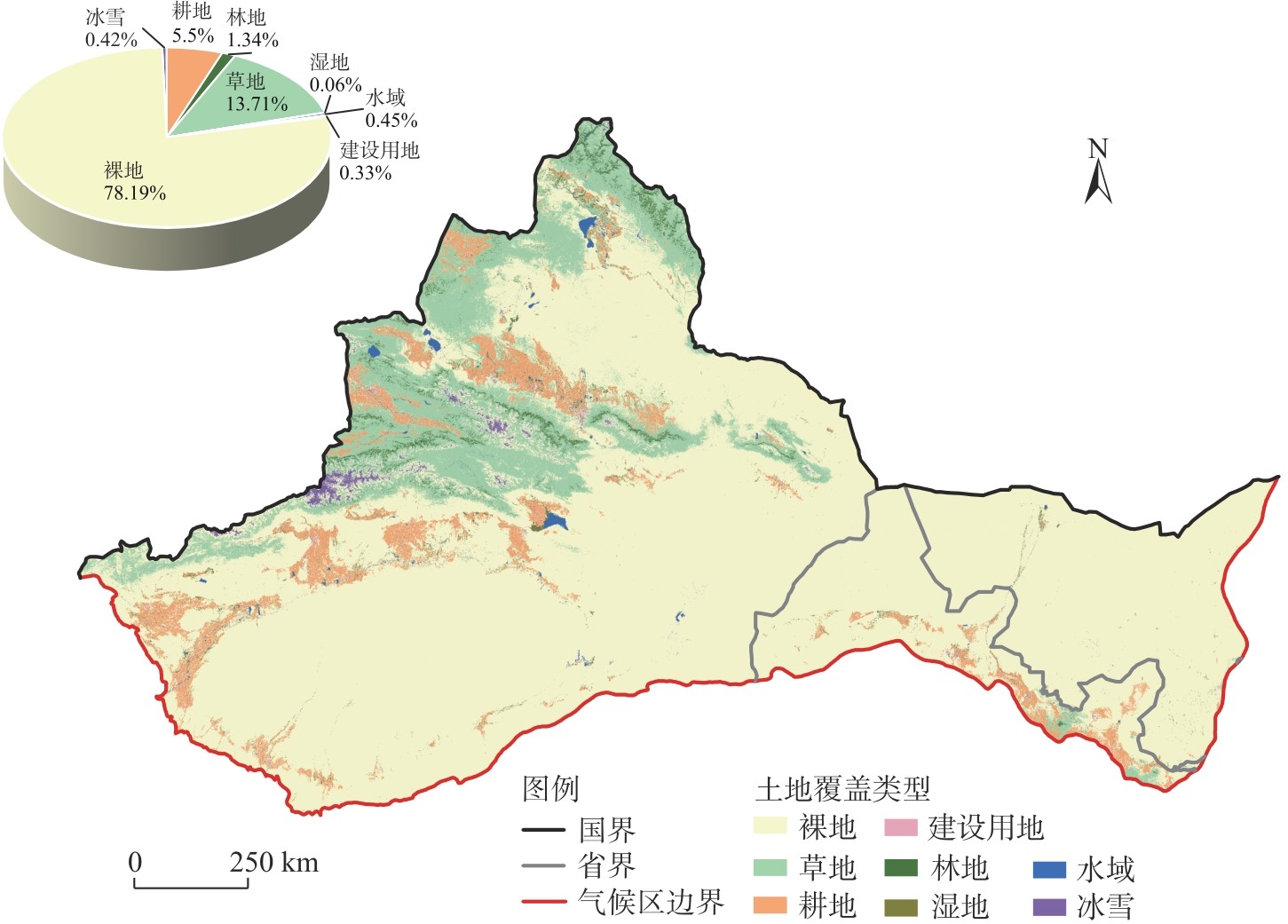
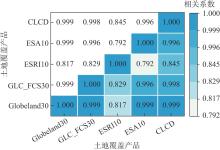
Fig. 4
Correlation of different land cover products"
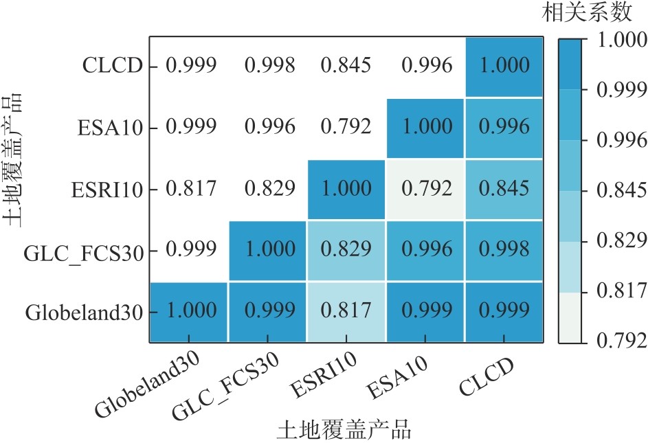
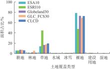
Fig. 5
Area proportion of different land cover types"
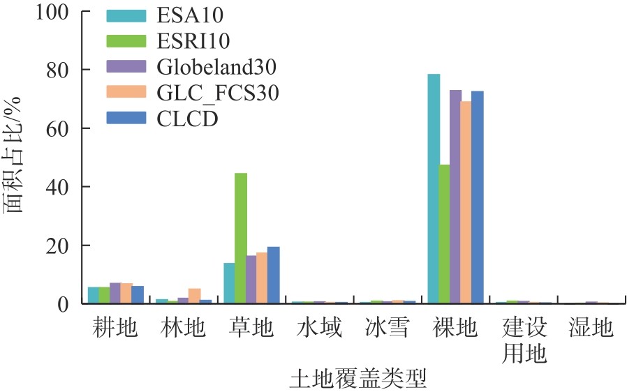
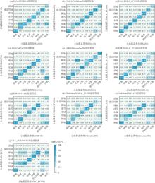
Fig. 6
Confusion degree of different land cover products"
Fig. 7
Spatial consistency of the four main land cover types"
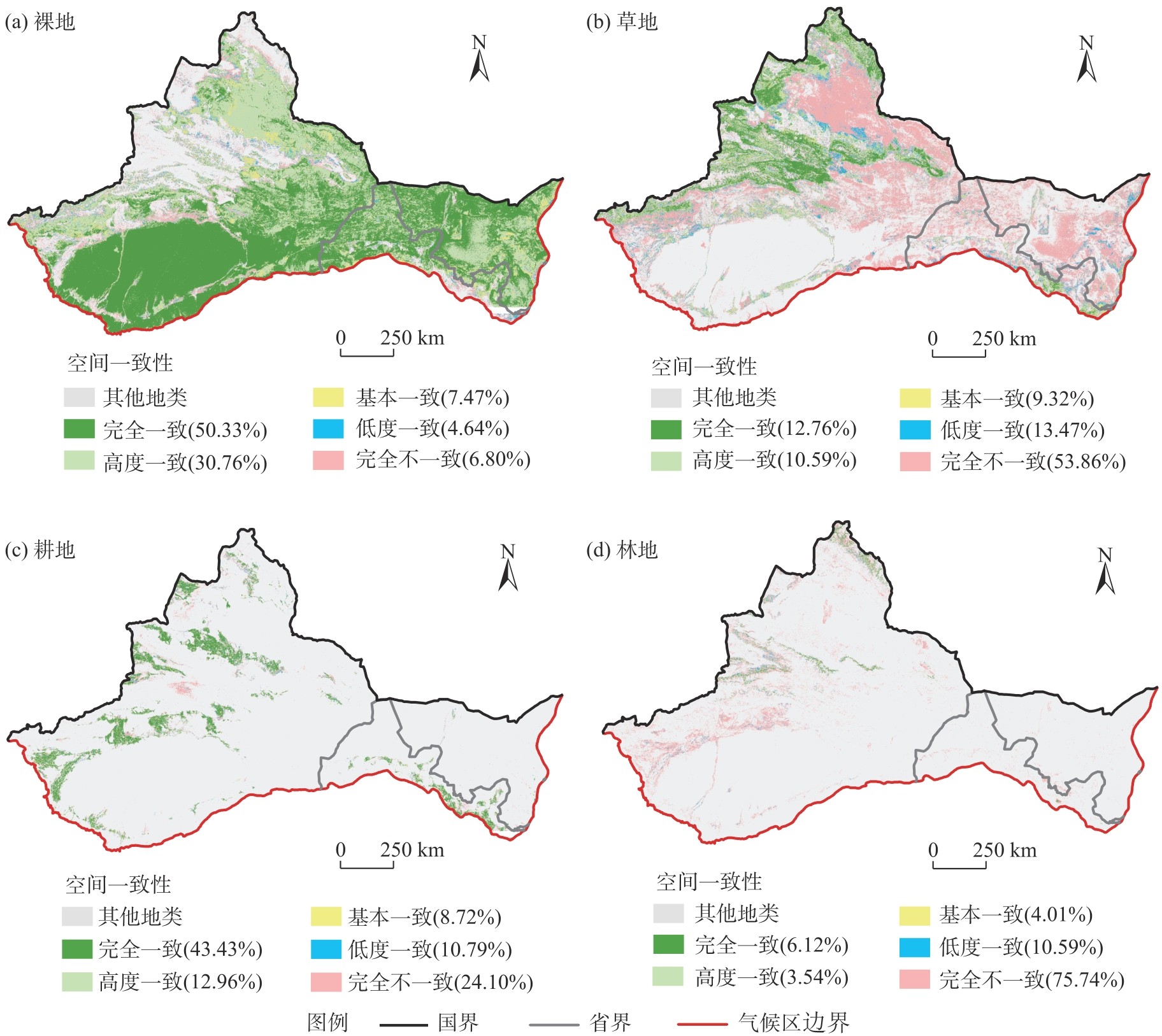
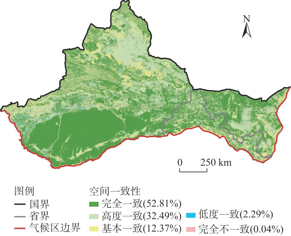
Fig. 8
Overall spatial consistency of multi-source land cover products"
| [1] | Chen J, Ban Y F, Li S N. Open access to earth land-cover map[J]. Nature, 2014, 514(7523): 434, doi: 10.1038/514-434c. |
| [2] |
牛飞飞, 郭靖, 罗杰, 等. 基于GeoSOS-FLUS和InVEST模型的新疆地区土地利用变化模拟及碳储量预测[J]. 干旱区地理, 2025, 48(12): 2169-2182.
doi: 10.12118/j.issn.1000-6060.2025.090 |
|
[Niu Feifei, Guo Jing, Luo Jie, et al. Simulation of land use change and prediction of carbon storage in Xinjiang based on GeoSOS-FLUS and InVEST models[J]. Arid Land Geography, 2025, 48(12): 2169-2182.]
doi: 10.12118/j.issn.1000-6060.2025.090 |
|
| [3] | Wang Y Q, Xu Y M, Xu X C, et al. Evaluation of six global high-resolution global land cover products over China[J]. International Journal of Digital Earth, 2024, 17(1): 2301673, doi: 10.1080/17538947.2023.2301673. |
| [4] |
Hansen M C, Defries R S, Townshend J R G, et al. Global land cover classification at 1 km spatial resolution using a classification tree approach[J]. International Journal of Remote Sensing, 2000, 21(6-7): 1331-1364.
doi: 10.1080/014311600210209 |
| [5] |
Li Z H, He W, Cheng M F, et al. SinoLC-1: The first 1 m resolution national-scale land-cover map of China created with a deep learning framework and open-access data[J]. Earth System Science Data, 2023, 15(11): 4749-4780.
doi: 10.5194/essd-15-4749-2023 |
| [6] | 黄昕, 李家艺, 杨杰, 等. Landsat卫星观测下的30 m全球不透水面年度动态与城市扩张模式(1972—2019)[J]. 中国科学: 地球科学, 2021, 51(11): 1894-1906. |
| [Huang Xin, Li Jiayi, Yang Jie, et al. 30 m global impervious surface area dynamics and urban expansion pattern observed by Landsat satellites: From 1972 to 2019[J]. Science China Earth Sciences, 2021, 51(11): 1894-1906.] | |
| [7] |
Friedl M A, Mciver D K, Hodges J C F, et al. Global land cover mapping from MODIS: Algorithms and early results[J]. Remote Sensing of Environment, 2002, 83(1-2): 287-302.
doi: 10.1016/S0034-4257(02)00078-0 |
| [8] |
Yang J, Huang X. The 30 m annual land cover dataset and its dynamics in China from 1990 to 2019[J]. Earth System Science Data, 2021, 13(8): 3907-3925.
doi: 10.5194/essd-13-3907-2021 |
| [9] |
王冰泉, 冉有华. 土地覆被遥感产品真实性检验方法对比[J]. 遥感技术与应用, 2022, 37(1): 196-204.
doi: 10.11873/j.issn.1004-0323.2022.1.0196 |
| [Wang Bingquan, Ran Youhua. Comparison of accuracy assessment methods of remote sensing based land cover products[J]. Remote Sensing Technology and Application, 2022, 37(1): 196-204.] | |
| [10] |
李广东. 全球土地覆被时空变化与中国贡献[J]. 地理学报, 2022, 77(2): 353-368.
doi: 10.11821/dlxb202202006 |
|
[Li Guangdong. Spatio-temporal change of global land cover and China’s contribution[J]. Acta Geographica Sinica, 2022, 77(2): 353-368.]
doi: 10.11821/dlxb202202006 |
|
| [11] |
仝冉, 杨雅萍, 陈晓娜. 多源30 m分辨率土地覆被数据在蒙古高原的一致性分析和精度评价[J]. 地球信息科学学报, 2022, 24(12): 2420-2434.
doi: 10.12082/dqxxkx.2022.220578 |
| [Tong Ran, Yang Yaping, Chen Xiaona. Consistent analysis and accuracy evaluation of multisource land cover datasets in 30 m spatial resolution over the Mongolian Plateau[J]. Journal of Geo-Information Science, 2022, 24(12): 2420-2434.] | |
| [12] | 魏冲, 董晓华, 马耀明, 等. 多源土地利用数据下景观格局对径流-泥沙影响的不确定性——以鄱阳湖区虎山流域为例[J]. 生态学报, 2025, 45(3): 1102-1115. |
| [Wei Chong, Dong Xiaohua, Ma Yaoming, et al. Uncertainty analysis on the effects of landscape pattern on runoff and sediment using multi-source land use data: A case study in the Hushan River Basin of the Poyang Lake regions[J]. Acta Ecologica Sinica, 2025, 45(3): 1102-1115.] | |
| [13] | 戴昭鑫, 胡云锋, 张千力. 多源卫星遥感土地覆被产品在南美洲的一致性分析[J]. 遥感信息, 2017, 32(2): 137-148. |
| [Dai Zhaoxin, Hu Yunfeng, Zhang Qianli. Consistency analysis of multi-source satellite remote sensing land cover products in south America[J]. Remote Sensing Information, 2017, 32(2): 137-148.] | |
| [14] |
徐泽源, 罗庆辉, 许仲林. 新疆地区土地覆被遥感数据的一致性研究[J]. 地球信息科学学报, 2019, 21(3): 427-436.
doi: 10.12082/dqxxkx.2019.180596 |
| [Xu Zeyuan, Luo Qinghui, Xu Zhonglin. Research on the consistency of remote sensing data of land cover in Xinjiang region[J]. Journal of Geo-Information Science, 2019, 21(3): 427-436.] | |
| [15] | 吴宗洋, 蔡卓雅, 郭英, 等. 黄河流域多源遥感土地覆被数据精度评价与一致性分析[J]. 中国生态农业学报, 2023, 31(6): 917-927. |
| [Wu Zongyang, Cai Zhuoya, Guo Ying, et al. Evaluation and consistency analysis of multi-source remote sensing land cover data accuracy in the Yellow River Basin[J]. Chinese Journal of Eco-Agriculture, 2023, 31(6): 917-927.] | |
| [16] |
连虎刚, 刘春芳, 倪博文, 等. 西北干旱区自然保护地体系生态网络构建及优化: 以河西走廊为例[J]. 应用生态学报, 2025, 36(1): 259-270.
doi: 10.13287/j.1001-9332.202501.021 |
|
[Lian Hugang, Liu Chunfang, Ni Bowen, et al. Construction and optimization of the ecological network of protected areas system in the arid regions of northwest China: A case study of Hexi Corridor[J]. Chinese Journal of Applied Ecology, 2025, 36(1): 259-270.]
doi: 10.13287/j.1001-9332.202501.021 |
|
| [17] |
周灵敏,伊木然·库鲁万, 玉素甫江·如素力, 等. 中国西北干旱区大型湖泊湖冰物候时空差异及影响因素[J]. 干旱区地理, 2026, 49(3): 484-495.
doi: 10.12118/j.issn.1000-6060.2025.281 |
|
[Zhou Lingmin, Kuluwan Yimuran, Rusuli Yusufujiang, et al. Spatiotemporal variations and influencing factors of lake ice phenology in large lakes of the arid region of northwest China[J]. Arid Land Geography, 2026, 49(3): 484-495.]
doi: 10.12118/j.issn.1000-6060.2025.281 |
|
| [18] |
Peng S Z, Ding Y X, Liu W Z, et al. 1 km monthly temperature and precipitation dataset for China from 1901 to 2017[J]. Earth System Science Data, 2019, 11(4): 1931-1946.
doi: 10.5194/essd-11-1931-2019 |
| [19] | Wang H, Yan H M, Hu Y F, et al. Consistency and accuracy of four high-resolution LULC datasets: Indochina Peninsula case study[J]. Land, 2022, 11(5): 758, doi: 10.3390/land11050758. |
| [20] |
闫兆进, 孙雨晴, He Rong, 等. 新疆天山北坡城市群土地覆被数据产品精度评价[J]. 干旱区地理, 2024, 47(11): 1852-1862.
doi: 10.12118/j.issn.1000-6060.2023.721 |
|
[Yan Zhaojin, Sun Yuqing, He Rong, et al. Evaluation of land cover data product accuracy in urban agglomeration on the northern slope of Tianshan Mountains in Xinjiang[J]. Arid Land Geography, 2024, 47(11): 1852-1862.]
doi: 10.12118/j.issn.1000-6060.2023.721 |
|
| [21] |
夏子龙, 杜培军, 郭山川, 等. 呼包鄂榆城市群遥感土地覆被产品评估分析与集成学习[J]. 干旱区地理, 2024, 47(8): 1367-1379.
doi: 10.12118/j.issn.1000-6060.2023.718 |
|
[Xia Zilong, Du Peijun, Guo Shanchuan, et al. Evaluation and ensemble learning of remote sensing land-cover products in the Hohhot-Baotou-Ordos-Yulin urban agglomeration[J]. Arid Land Geography, 2024, 47(8): 1367-1379.]
doi: 10.12118/j.issn.1000-6060.2023.718 |
|
| [22] | Zhang W G, Tian J J, Zhang X H, et al. Which land cover product provides the most accurate land use land cover map of the Yellow River Basin?[J]. Frontiers in Ecology and Evolution, 2023, 11: 1275054, doi: 10.3389/fevo.2023.1275054. |
|
||

