Arid Land Geography ›› 2022, Vol. 45 ›› Issue (3): 695-705.doi: 10.12118/j.issn.1000-6060.2021.335
• Climate Change • Previous Articles Next Articles
JIN Ling1( ),WANG Yongfang1,2,3(),GUO Enliang1,2,LIU Guixiang3,BAO Yulong1,2
Received:2021-07-23
Revised:2021-10-29
Online:2022-05-25
Published:2022-05-31
Contact:
Yongfang WANG
E-mail:jinling257@163.com;wangyongfang@imnu.edu.cn
JIN Ling,WANG Yongfang,GUO Enliang,LIU Guixiang,BAO Yulong. Evaluation of drought hazards in Inner Mongolia based on SPEIbase v.2.6 dataset[J].Arid Land Geography, 2022, 45(3): 695-705.
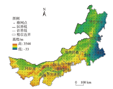
Fig. 1
Distributions of the study area and grid points"

Tab. 1
Criteria for classification of drought based on SPEI"
| 等级 | 类型 | SPEI值 |
|---|---|---|
| 1 | 无旱 | SPEI>-0.5 |
| 2 | 轻旱 | -1.0<SPEI≤-0.5 |
| 3 | 中旱 | -1.5<SPEI≤-1.0 |
| 4 | 重旱 | -2.0<SPEI≤-1.5 |
| 5 | 特旱 | SPEI≤-2.0 |
Tab. 2
Classification of drought hazard in Inner Mongolia"
| 等级 | 极高危险性 | 高危险性 | 中危险性 | 低危险性 | 极低危险性 |
|---|---|---|---|---|---|
| 干旱危险性指数 | [-23.51, -18.63) | [-18.63, -17.42) | [-17.42, -16.04) | [-16.04, -11.61) | [-11.61, -2.90] |

Fig. 2
Inter-annual change characteristics of annual drought"
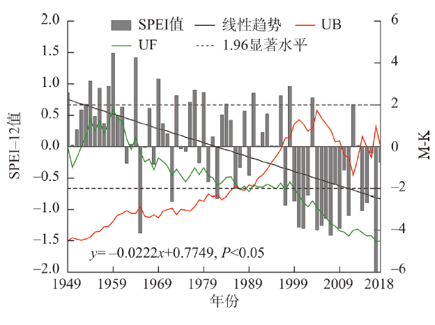

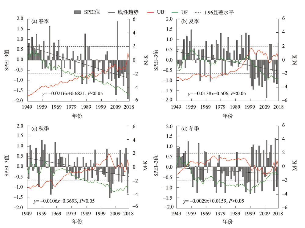
Fig. 3
Inter-annual change characteristics of seasonal drought"
Tab. 3
Statistics of grid points for different types of drought and trends"
| 类型 | 上升趋势 | 显著上升 | 非显著上升 | 下降趋势 | 显著下降 | 非显著下降 |
|---|---|---|---|---|---|---|
| 年干旱 | 0 | 0 | 0 | 460 | 413 | 47 |
| 春季干旱 | 0 | 0 | 0 | 460 | 446 | 14 |
| 夏季干旱 | 1 | 1 | 0 | 459 | 249 | 210 |
| 秋季干旱 | 37 | 3 | 34 | 423 | 183 | 240 |
| 冬季干旱 | 162 | 23 | 139 | 298 | 119 | 179 |

Fig. 4
Change characteristics of annual drought trend"
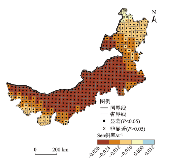

Fig. 5
Change characteristics of seasonal drought trend"
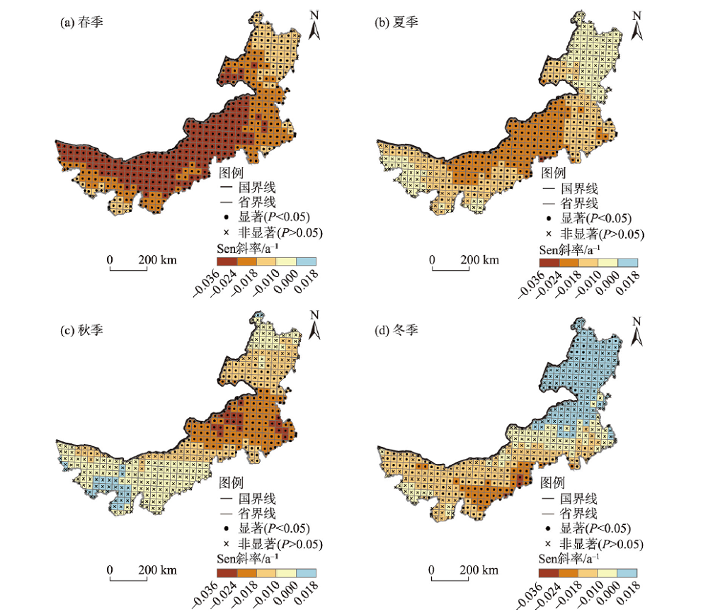

Fig. 6
Spatial distribution of annual drought hazard"

Fig. 7
Spatial distributions of drought hazard in four seasons"

| [1] | 司文洋, 张明军, 刘普幸. 中国绿洲喜温作物气候生长期对全球变暖停滞响应的时空差异[J]. 干旱区地理, 2020, 43(4): 899-908. |
| [ Si Wenyang, Zhang Mingjun, Liu Puxing. Spatial and temporal response differences to global warming hiatus of the thermophilic crops climate growth period in oases of China[J]. Arid Land Geography, 2020, 43(4): 899-908. ] | |
| [2] | IPCC. Climate change 2021: The physical science basis[M]. Cambridge: Cambridge University Press, 2021. |
| [3] | 张音, 古丽贤·吐尔逊拜, 苏里坦, 等. 近60 a来新疆不同海拔气候变化的时空特征分析[J]. 干旱区地理, 2019, 42(4): 822-829. |
| [ Zhang Yin, Tuerxunbat Gulixian, Su Litan, et al. Spatial and temporal characteristics of climate change at different altitudes in Xinjiang in the past 60 years[J]. Arid Land Geography, 2019, 42(4): 822-829. ] | |
| [4] | 赵铁松, 王丽荣, 郭恩亮, 等. 基于Copula函数的降水事件危险性评估--以子牙河流域典型区为例[J]. 自然灾害学报, 2020, 29(6): 199-208. |
| [ Zhao Tiesong, Wang Lirong, Guo Enliang, et al. Hazard assessment of precipitation events based on Copula function: Take the typical area of Ziya River Basin as an example[J]. Journal of Natural Disasters, 2020, 29(6): 199-208. ] | |
| [5] | 支询, 林中冠, 沙莉, 等. 川南地区1989-2019年农业干旱危险性特征分析[J]. 农学学报, 2020, 10(8): 78-82. |
| [ Zhi Xun, Lin Zhongguan, Sha Li, et al. Agricultural drought hazard characteristics in southern Sichuan during 1989-2019 [J]. Journal of Agriculture, 2020, 10(8): 78-82. ] | |
| [6] | 黄浩, 张勃, 马尚谦, 等. 甘肃河东地区气象干旱时空变化及干旱危险性分析[J]. 中国农业气象, 2020, 41(7): 459-469. |
| [ Huang Hao, Zhang Bo, Ma Shangqian, et al. Temporal and spatial variations of meteorological drought and drought risk analysis in Hedong area of Gansu Province[J]. Chinese Journal of Agrometeorology, 2020, 41(7): 459-469. ] | |
| [7] | 张玉静, 王春乙, 张继权. 华北地区冬小麦干旱危险性分析[J]. 自然灾害学报, 2014, 23(6): 183-192. |
| [ Zhang Yujing, Wang Chunyi, Zhang Jiquan. Hazard analysis of drought disaster for winter wheat in north China[J]. Journal of Natural Disasters, 2014, 23(6): 183-192. ] | |
| [8] | 费振宇, 孙宏巍, 金菊良, 等. 近50年中国气象干旱危险性的时空格局探讨[J]. 水电能源科学, 2014, 32(12): 5-10. |
| [ Fei Zhenyu, Sun Hongwei, Jin Juliang, et al. Temporal and spatial patterns of meteorological drought hazard in China for recent 50 years[J]. Water Resources and Power, 2014, 32(12): 5-10. ] | |
| [9] | 谭春萍, 杨建平, 杨圆, 等. 宁夏回族自治区干旱致灾危险性时空变化特征[J]. 灾害学, 2015, 30(2): 89-93. |
| [ Tan Chunping, Yang Jianping, Yang Yuan, et al. Spatial-temporal variation of drought hazard in Ningxia Hui Autonomous Region, China[J]. Journal of Catastrophology, 2015, 30(2): 89-93. ] | |
| [10] | 支询, 沙莉, 李施, 等. 宜宾市农业干旱危险性演变特征分析[J]. 现代农业科技, 2019(19): 191-193, 195. |
| [ Zhi Xun, Sha Li, Li Shi, et al. Analysis on evolution characteristics of agricultural drought risk in Yibin City[J]. Modern Agricultural Science and Technology, 2019(19): 191-193, 195. ] | |
| [11] | 陈家金, 黄川容, 孙朝锋, 等. 福建省茶叶气象灾害致灾危险性区划与评估[J]. 自然灾害学报, 2018, 27(1): 198-207. |
| [ Chen Jiajin, Huang Chuanrong, Sun Chaofeng, et al. Disaster-causing hazard division and evaluation of meteorological disasters for tea in Fujian Province[J]. Journal of Natural Disasters, 2018, 27(1): 198-207. ] | |
| [12] | 马凯, 徐玉霞, 方锋. 蚂蚁森林种植地鄂尔多斯市1959-2018年气温及降水变化特征研究[J]. 水资源与水工程学报, 2019, 30(6): 109-115. |
| [ Ma Kai, Xu Yuxia, Fang Feng. Study on temperature and precipitation change characteristics of ant forest plantation in Ordos City from 1959 to 2018[J]. Journal of Water Resources & Water Engineering, 2019, 30(6): 109-115. ] | |
| [13] | 杨舒畅, 杨恒山. 1982-2013年内蒙古地区干旱变化及植被响应[J]. 自然灾害学报, 2019, 28(1): 175-183. |
| [ Yang Shuchang, Yang Hengshan. Drought evolution and vegetation response in Inner Mongolia from 1982 to 2013[J]. Journal of Natural Disasters, 2019, 28(1): 175-183. ] | |
| [14] | 代海燕, 李丹, 娜日苏, 等. 内蒙古干湿环境演变与地区生态建设优势气候背景分析[J]. 干旱区地理, 2019, 42(4): 745-752. |
| [ Dai Haiyan, Li Dan, Na Risu, et al. Dry and wet environment evolution and climatic background analysis of regional ecological construction in Inner Mongolia[J]. Arid Land Geography, 2019, 42(4): 745-752. ] | |
| [15] | 张思源, 聂莹, 张海燕, 等. 基于地理探测器的内蒙古植被NDVI时空变化与驱动力分析[J]. 草地学报, 2020, 28(5): 1460-1472. |
| [ Zhang Siyuan, Nie Ying, Zhang Haiyan, et al. Spatiotemporal variation of vegetation NDVI and its driving forces in Inner Mongolia based on geodetector[J]. Acta Agrestia Sinica, 2020, 28(5): 1460-1472. ] | |
| [16] |
李文龙, 匡文慧, 吕君, 等. 北方农牧交错区人地系统演化特征与影响机理--以内蒙古达茂旗为例[J]. 地理学报, 2021, 76(2): 487-502.
doi: 10.11821/dlxb202102017 |
|
[ Li Wenlong, Kuang Wenhui, Lü Jun, et al. Adaptive evolution mechanism of rural human-land system in farming-and-pastoral areas of northern China[J]. Acta Geographica Sinica, 2021, 76(2): 487-502. ]
doi: 10.11821/dlxb202102017 |
|
| [17] | 王举凤, 何亮, 陆绍娟, 等. 内蒙古不同类型草原光合植被覆盖度对降水变化的响应[J]. 生态学报, 2020, 40(16): 5620-5629. |
| [ Wang Jufeng, He Liang, Lu Shaojuan, et al. Photosynthetic vegetation cover response to precipitation on the Inner Mongolian steppe[J]. Acta Ecologica Sinica, 2020, 40(16): 5620-5629. ] | |
| [18] |
Vicente-Serrano S M, Beguería S, López-Moreno J I, et al. A new global 0.5° gridded dataset (1901-2006) of a multiscalar drought index: Comparison with current drought index datasets based on the Palmer drought severity index[J]. Journal of Hydrometeorology, 2010, 11(4): 1033-1043.
doi: 10.1175/2010JHM1224.1 |
| [19] | GBT20481-2017 气象干旱等级 [S]北京: 中国标准出版社, 2006. |
| [ GBT20481-2017. Meteorological drought grade[S]. Beijing: China Standard Press, 2006. ] | |
| [20] | 肖杨, 周旭, 罗雪, 等. 黔中地区近60年潜在蒸散量时空变化特征及主导因素识别[J]. 水土保持研究, 2021, 28(6): 1-9. |
| [ Xiao Yang, Zhou Xu, Luo Xue, et al. Spatiotemporal variation characteristics of potential evapotranspiration and identification of leading factors in central Guizhou in recent 60 years[J]. Research of Soil and Water Conservation, 2021, 28(6): 1-9. ] | |
| [21] | 宁忠瑞, 张建云, 王国庆. 1948-2016年全球主要气象要素演变特征及空间分布格局[J]. 中国环境科学, 2021, 41(9): 4085-4095. |
| [ Ning Zhongrui, Zhang Jianyun, Wang Guoqing. Variation and global pattern of major meteorological elements during 1948-2016[J]. China Environmental Science, 2021, 41(9): 4085-4095. ] | |
| [22] | 谢慧君, 张廷斌, 易桂花, 等. 川西高原植被NDVI动态变化特征及对气候因子的响应[J]. 水土保持通报, 2020, 40(4): 286-294. |
| [ Xie Huijun, Zhang Tingbin, Yi Guihua, et al. Dynamic characteristics of NDVI values and its response to climatic factors in western Sichuan Plateau[J]. Bulletin of Soil and Water Conservation, 2020, 40(4): 286-294. ] | |
| [23] | 刘小园, 刘希胜. 青海省湿地面积变化特征及成因分析[J]. 人民黄河, 2021, 43(8): 90-95. |
| [ Liu Xiaoyuan, Liu Xisheng. Variation characteristics and cause analysis of wetland area in Qinghai Province[J]. Yellow River, 2021, 43(8): 90-95. ] | |
| [24] | 李乃强, 徐贵阳. 基于自然间断点分级法的土地利用数据网格化分析[J]. 测绘通报, 2020(4): 106-110, 156. |
| [ Li Naiqiang, Xu Guiyang. Grid analysis of land use based on natural breaks (jenks) classification[J]. Bulletin of Surveying and Mapping, 2020(4): 106-110, 156. ] | |
| [25] | 卢瑜, 向平安, 余亮. 中国有机农业的集聚与空间依赖性[J]. 中国生态农业学报, 2021, 29(3): 440-452. |
| [ Lu Yu, Xiang Ping’an, Yu Liang. Agglomeration and spatial dependence of organic agriculture in China[J]. Chinese Journal of Eco-Agriculture, 2021, 29(3): 440-452. ] | |
| [26] |
Wang Y F, Liu G X, Guo E L. Spatial distribution and temporal variation of drought in Inner Mongolia during 1901-2014 using standardized precipitation evapotranspiration index[J]. Science of the Total Environment, 2019, 654: 850-862.
doi: 10.1016/j.scitotenv.2018.10.425 |
| [27] | 佟斯琴. 气候变化背景下内蒙古地区气象干旱时空演变及预估研究[D]. 长春: 东北师范大学, 2019. |
| [ Tong Siqin. Spatio-temporal variations and prediction of meteorological drought in Inner Mongolia under climate change[D]. Changchun: Northeast Normal University, 2019. ] | |
| [28] | 郭婷, 薛彪, 周艳明, 等. 我国牧草产品生产、贸易现状及启示[J]. 草地学报, 2019, 27(1): 8-14. |
| [ Guo Ting, Xue Biao, Zhou Yanming, et al. Current status and enlightenment of production and trade of forage production in China[J]. Acta Agrestia Sinica, 2019, 27(1): 8-14. ] | |
| [29] | 吴英杰, 李玮, 王文君, 等. 基于降水量距平百分率的内蒙古地区干旱特征[J]. 干旱区研究, 2019, 36(4): 943-952. |
| [ Wu Yingjie, Li Wei, Wang Wenjun, et al. Drought characteristics in Inner Mongolia based on anomaly percentage[J]. Arid Zone Research, 2019, 36(4): 943-952. ] | |
| [30] | Thornthwaite C W. An approach toward a rational classification of climate[J]. Soil Science, 1948, 66(1): 77. |
| [31] | 覃艺. 基于SPEI和TVDI的内蒙古综合干旱监测[D]. 成都: 成都理工大学, 2020. |
| [ Tan Yi. Comprehensive drought monitoring based on SPEI and TVDI in Inner Mongolia, China[D]. Chengdu: Chengdu University of Technology, 2020. ] | |
| [32] | 赵佳琪, 张强, 朱秀迪, 等. 中国旱灾风险定量评估[J]. 生态学报, 2021, 41(3): 1021-1031. |
| [ Zhao Jiaqi, Zhang Qiang, Zhu Xiudi, et al. Quantitative assessment of drought risk in China[J]. Acta Ecologica Sinica, 2021, 41(3): 1021-1031. ] | |
| [33] | 张存厚, 张立, 吴英杰, 等. 内蒙古草原干旱灾害综合风险评估[J]. 干旱区资源与环境, 2019, 33(7): 115-121. |
| [ Zhang Cunhou, Zhang Li, Wu Yingjie, et al. Assessment on the integrated drought disaster risk in Inner Mongolia grassland[J]. Journal of Arid Land Resources and Environment, 2019, 33(7): 115-121. ] |
| [1] | MENG Xiao, TIAN Minghua, DU Lei, MA Shuang. Measurement and its coordination of the development level of agricultural and rural modernization in China [J]. Arid Land Geography, 2024, 47(1): 137-146. |
| [2] | NIU Yiying, LI Chunlan, WANG Jun, XU Hanqing, LIU Qing. Performance evaluation of ERA5 reanalysis precipitation data and spatiotemporal characteristics of extreme precipitation in Inner Mongolia [J]. Arid Land Geography, 2023, 46(9): 1418-1431. |
| [3] | LU Dongyan, ZHU Xiufang, LIU Tingting, ZHANG Shizhe. Changes in meteorological drought characteristics in China under the 2 ℃ temperature rise scenario [J]. Arid Land Geography, 2023, 46(8): 1227-1237. |
| [4] | CHENG Shuo, LI Yanzhong, XING Yincong, YU Zhiguo, WANG Yuangang, HUANG Manjie. Simulation performance of remote sensing precipitation products on hydrological drought characteristics in the source region of the Yellow River [J]. Arid Land Geography, 2023, 46(7): 1063-1072. |
| [5] | SHI Jiqing, GAN Chenlong, ZHOU Kanshe, YUAN Lei, ZHANG Dongdong. Spatiotemporal distribution of drought and hazard assessment of highland barley in Tibet [J]. Arid Land Geography, 2023, 46(7): 1098-1110. |
| [6] | NING Jing, ZHU Ran, ZHANG Xinyuan, CHEN Kai. Evaluation and analysis of urban resilience of districts and counties in Inner Mongolia [J]. Arid Land Geography, 2023, 46(7): 1217-1226. |
| [7] | SA Rigai, BAO Yuhai, DOU Yinyin, DONG Yulin, PAN Tao, KUANG Wenhui. Impacts of urban and rural construction on ecosystem productivity in Inner Mongolia Plateau from 2000 to 2020 [J]. Arid Land Geography, 2023, 46(6): 922-933. |
| [8] | WANG Jianian, LI Xiangyi, LI Chengdao, ZHANG Ailin, LIN Lisha. Decomposition characteristics of two desert plant leaf under natural light and shade environment [J]. Arid Land Geography, 2023, 46(6): 949-957. |
| [9] | ZHOU Haitao, MA Yusong, FAN Yayu, NING Xiaoli. Spatial distribution and accessibility analysis of red tourism resources in Inner Mongolia [J]. Arid Land Geography, 2023, 46(5): 814-822. |
| [10] | REN Taotao,LI Shuangshuang,DUAN Keqin,HE Jinping. Spatiotemporal variation characteristics and influencing factors of heat wave and precipitation deficit flash drought in the Loess Plateau [J]. Arid Land Geography, 2023, 46(3): 360-370. |
| [11] | XU Xintong,ZHU Li,LYU Xiaoyu,GUO Hao. Applicability evaluation of MSWEP product for meteorological drought monitoring in the Yellow River Basin [J]. Arid Land Geography, 2023, 46(3): 371-384. |
| [12] | SUN Nansha,CHEN Qiong,LIU Fenggui,ZHOU Qiang,GUO Yuanyuan. Agricultural drought research in Yellow River-Huangshui River Valley from 2000 to 2020 [J]. Arid Land Geography, 2023, 46(3): 437-447. |
| [13] | DONG Youming, QIAO Wenyi, LIU Zemiao, HUANG Xianjin. Characteristics of rural restructuring and problem areas identification in agro-pastoral area of northern China: A case of the Inner Mongolia section in the Yellow River Basin [J]. Arid Land Geography, 2023, 46(11): 1891-1902. |
| [14] | CAO Yujuan, SI Wenyang, DU Ziqiang, LIANG Hanxue, LEI Tianjie, SUN Bin, WU Zhitao. Changes in GPP of China during the typical drought years from 1982 to 2017 [J]. Arid Land Geography, 2023, 46(10): 1577-1590. |
| [15] | ZHANG Juan, YAO Xiaojun, LI Jing, WANG Xiaoyan. Agricultural drought research based on multi-source remote sensing data in Gansu Province [J]. Arid Land Geography, 2023, 46(1): 11-22. |
|
||