干旱区地理 ›› 2022, Vol. 45 ›› Issue (2): 401-412.doi: 10.12118/j.issn.1000–6060.2021.282 cstr: 32274.14.ALG2021282
孙桂丽1,2( ),李雪1,刘燕燕1,郑佳翔1,马婧1,冉亚军1
收稿日期:2021-06-18
修回日期:2021-10-17
出版日期:2022-03-25
发布日期:2022-04-02
作者简介:孙桂丽(1979-),女,教授,主要从事风险评估与生态恢复等方面的研究. E-mail: 基金资助:
SUN Guili1,2(),LI Xue1,LIU Yanyan1,ZHENG Jiaxiang1,MA Jing1,RAN Yajun1
Received:2021-06-18
Revised:2021-10-17
Published:2022-03-25
Online:2022-04-02
摘要:
荒漠化是当今最为严重的生态问题之一,开展荒漠化风险量化评估,有助于荒漠化风险调控,实现区域生态经济可持续发展。通过从气候、下垫面和社会经济等因素选取指标,构建吐鲁番市荒漠化风险评价体系,基于3S技术分析评估其2000—2018年的荒漠化风险程度,并采用地理探测器进行驱动力分析。结果表明:(1) 2000—2018年吐鲁番市荒漠化风险变化较大,总体呈现出局部变差整体向好的趋势,东部荒漠化风险程度高于西部地区。(2) 研究时段内吐鲁番市东部鄯善县的极高风险面积增加;西部托克逊县的极高风险范围得到控制,面积明显缩小;中部高昌区极低风险面积减少,低度风险分布较为稳定。(3) 单因子驱动力:起沙风天数、第一产业GDP、降水量、生境质量指数、牲畜数量、平均气温6个因子对吐鲁番市荒漠化风险影响较大;在两两指标交互作用中,起沙风天数与第一产业GDP、降水量、生境质量指数、平均气温、牲畜数量的相互耦合是影响荒漠化风险的主要因素。
孙桂丽,李雪,刘燕燕,郑佳翔,马婧,冉亚军. 吐鲁番市荒漠化风险动态变化及驱动力分析[J]. 干旱区地理, 2022, 45(2): 401-412.
SUN Guili,LI Xue,LIU Yanyan,ZHENG Jiaxiang,MA Jing,RAN Yajun. Dynamic changes on desertification risk assessment and driving force analysis in Turpan City[J]. Arid Land Geography, 2022, 45(2): 401-412.
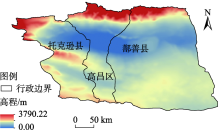
图1
研究区概况图"

表1
数据来源与数据处理"
| 名称 | 数据来源 | 数据处理 |
|---|---|---|
| 土地利用数据 | 吐鲁番市的2000、2005、2010、2015、2018年土地利用数据来自云地理监测平台 ( | 基于Landsat遥感影像经过校准得到2000、2005、2010、2015、2018年的二级分类矢量数据。 |
| 气象数据 | 降水量、平均气温来源于中国科学院资源环境科学数据中心,起沙风天数、平均风速来源于中国气象数据网,均为气象站点数据。 | 所选2000、2005、2010、2015、2018年数据在ArcGIS里进行反向距离加权平均空间插值处理。 |
| 下垫面数据 | 包括2000、2005、2010、2015、2018年植被覆盖度、生境质量指数、坡度、坡向。坡度、坡向数据来源于地理空间数据云,分辨率为90 m;植被覆盖度的提取基于NDVI数据。 | 在ArcGIS中利用栅格计算器计算吐鲁番市的植被覆盖度,生境质量指数见研究方法。 |
| 社会经济数据 | 2000、2005、2010、2015、2018年人口密度、牲畜数量(包括牛、羊、猪、马)、第一产业GDP(农、林、牧、渔)。人口数据来源于中国科学院资源环境科学数据中心;牲畜数量、第一产业GDP来源于2001、2006、2011、2016、2019年的新疆统计年鉴。 | 在ArcGIS里将数据进行空间化处理,然后转换成统一的格式和栅格大小。 |
表2
吐鲁番市荒漠化风险评价指标体系"
| 目标层 | 因子层 | 指标层 | 权重 | 属性 |
|---|---|---|---|---|
| 荒漠化风险评价 | 气候因素 | 降水量 | 0.1120 | + |
| 平均气温 | 0.0564 | - | ||
| 平均风速 | 0.0291 | - | ||
| 起沙风天数 | 0.0462 | - | ||
| 下垫面因素 | 坡度 | 0.0327 | - | |
| 坡向 | 0.0241 | - | ||
| 植被覆盖度 | 0.1465 | + | ||
| 生境质量指数 | 0.1454 | + | ||
| 社会因素 | 人口密度 | 0.1576 | - | |
| 牲畜数量 | 0.0735 | - | ||
| 第一产业GDP | 0.1765 | + |
图2
吐鲁番市荒漠化风险分布"
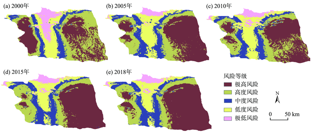
表3
2000—2018年吐鲁番市荒漠化风险面积转移矩阵"
| 年份 | 风险等级 | 2005年 | ||||
|---|---|---|---|---|---|---|
| 极高风险 | 高度风险 | 中度风险 | 低度风险 | 极低风险 | ||
| 2000年 | 极高风险 | 18129.98 | 4901.88 | 84.25 | 0.66 | 0.00 |
| 高度风险 | 9861.46 | 8694.98 | 2038.37 | 4.00 | 0.00 | |
| 中度风险 | 2.44 | 1470.68 | 6616.03 | 836.46 | 7.41 | |
| 低度风险 | 0.00 | 1.23 | 2927.81 | 6743.81 | 364.25 | |
| 极低风险 | 0.00 | 0.00 | 13.62 | 3943.25 | 2107.37 | |
| 年份 | 风险等级 | 2010年 | ||||
| 极高风险 | 高度风险 | 中度风险 | 低度风险 | 极低风险 | ||
| 2005年 | 极高风险 | 23360.11 | 4454.11 | 187.93 | 0.64 | 0.00 |
| 高度风险 | 1413.59 | 12014.36 | 1428.50 | 218.46 | 0.00 | |
| 中度风险 | 0.00 | 466.45 | 9156.23 | 1968.39 | 89.35 | |
| 低度风险 | 0.00 | 2.26 | 398.88 | 10022.84 | 1103.27 | |
| 极低风险 | 0.00 | 0.00 | 0.00 | 38.66 | 2446.64 | |
| 年份 | 风险等级 | 2015年 | ||||
| 极高风险 | 高度风险 | 中度风险 | 低度风险 | 极低风险 | ||
| 2010年 | 极高风险 | 22698.73 | 2058.63 | 15.16 | 0.00 | 0.00 |
| 高度风险 | 5925.72 | 10437.82 | 582.51 | 0.30 | 0.00 | |
| 中度风险 | 134.03 | 2333.17 | 8350.27 | 363.01 | 0.00 | |
| 低度风险 | 0.00 | 201.34 | 2939.76 | 8786.99 | 326.99 | |
| 极低风险 | 0.00 | 0.00 | 61.10 | 682.70 | 2907.78 | |
| 年份 | 风险等级 | 2018年 | ||||
| 极高风险 | 高度风险 | 中度风险 | 低度风险 | 极低风险 | ||
| 2015年 | 极高风险 | 28556.53 | 205.05 | 4.12 | 0.00 | 0.00 |
| 高度风险 | 2230.18 | 12642.02 | 150.23 | 1.28 | 0.00 | |
| 中度风险 | 19.60 | 1623.52 | 10127.96 | 162.51 | 0.18 | |
| 低度风险 | 0.00 | 2.41 | 1167.71 | 8511.66 | 138.62 | |
| 极低风险 | 0.00 | 0.70 | 2.75 | 410.42 | 2791.21 | |
表4
吐鲁番市荒漠化风险等级的多度指数"
| 区域 | 2000年 | ||||
|---|---|---|---|---|---|
| 极高风险 | 高度风险 | 中度风险 | 低度风险 | 极低风险 | |
| 高昌区 | 0.00 | 8.74 | 27.18 | 41.75 | 22.33 |
| 鄯善县 | 33.18 | 54.79 | 9.80 | 6.24 | 1.78 |
| 托克逊县 | 21.43 | 37.76 | 24.49 | 13.27 | 3.06 |
| 区域 | 2005年 | ||||
| 极高风险 | 高度风险 | 中度风险 | 低度风险 | 极低风险 | |
| 高昌区 | 0.00 | 7.14 | 6.35 | 19.05 | 17.46 |
| 鄯善县 | 10.99 | 62.27 | 15.02 | 6.23 | 5.49 |
| 托克逊县 | 20.57 | 39.72 | 21.99 | 13.48 | 4.26 |
| 区域 | 2010年 | ||||
| 极高风险 | 高度风险 | 中度风险 | 低度风险 | 极低风险 | |
| 高昌区 | 0.00 | 2.27 | 57.95 | 21.59 | 18.18 |
| 鄯善县 | 13.48 | 66.67 | 10.64 | 5.91 | 3.31 |
| 托克逊县 | 17.68 | 35.36 | 31.49 | 12.15 | 3.31 |
| 区域 | 2015年 | ||||
| 极高风险 | 高度风险 | 中度风险 | 低度风险 | 极低风险 | |
| 高昌区 | 0.00 | 3.96 | 34.65 | 38.61 | 22.77 |
| 鄯善县 | 10.90 | 40.38 | 21.79 | 15.38 | 11.54 |
| 托克逊县 | 15.64 | 22.64 | 38.68 | 11.32 | 4.72 |
| 区域 | 2018年 | ||||
| 极高风险 | 高度风险 | 中度风险 | 低度风险 | 极低风险 | |
| 高昌区 | 0.00 | 7.38 | 33.61 | 36.89 | 22.13 |
| 鄯善县 | 14.29 | 37.01 | 24.03 | 12.34 | 12.34 |
| 托克逊县 | 31.67 | 14.17 | 38.33 | 12.50 | 3.33 |

图3
吐鲁番市荒漠化风险等级的重要度指数"

表5
单因子的相关性指数"
| 评价因子 | 相关性指数(q值) |
|---|---|
| 起沙风天数 | 0.1989 |
| 第一产业GDP | 0.1710 |
| 降水量 | 0.1666 |
| 生境质量指数 | 0.1451 |
| 牲畜数量 | 0.1410 |
| 平均气温 | 0.1373 |
| 坡度 | 0.0994 |
| 平均风速 | 0.0549 |
| 人口密度 | 0.0431 |
| 植被覆盖度 | 0.0427 |
| 坡向 | 0.0230 |
表6
主要因子的双因子增强结果"
| 交互类型 | 交互值 | 交互类型 | 交互值 |
|---|---|---|---|
| 坡度∩降水量 | 0.2659 | 起沙风天数∩生境质量指数 | 0.3440 |
| 平均风速∩起沙风天数 | 0.2537 | 降水量∩平均气温 | 0.3039 |
| 牲畜数量∩生境质量指数 | 0.2861 | 降水量∩第一产业GDP | 0.3376 |
| 起沙风天数∩降水量 | 0.3655 | 降水量∩牲畜数量 | 0.3076 |
| 起沙风天数∩牲畜数量 | 0.3399 | 降水量∩生境质量指数 | 0.3117 |
表7
主要因子的非线性增强结果"
| 交互类型 | 交互值 | 交互类型 | 交互值 |
|---|---|---|---|
| 坡度∩起沙风天数 | 0.2982 | 植被覆盖度∩降水量 | 0.2093 |
| 坡度∩平均气温 | 0.2659 | 植被覆盖度∩第一产业GDP | 0.2137 |
| 坡度∩人口密度 | 0.2367 | 平均气温∩第一产业GDP | 0.3083 |
| 坡度∩牲畜数量 | 0.2703 | 平均气温∩牲畜数量 | 0.2783 |
| 平均风速∩第一产业GDP | 0.2259 | 平均气温∩生境质量指数 | 0.2824 |
| 坡向∩起沙风天数 | 0.2219 | 人口密度∩第一产业GDP | 0.2141 |
| 起沙风天数∩植被覆盖度 | 0.2416 | 人口密度∩牲畜数量 | 0.1841 |
| 起沙风天数∩平均气温 | 0.3362 | 人口密度∩生境质量指数 | 0.1882 |
| 起沙风天数∩人口密度 | 0.2420 | 第一产业GDP∩牲畜数量 | 0.3120 |
| 起沙风天数∩第一产业GDP | 0.3699 | 第一产业GDP∩生境质量指数 | 0.3161 |
表8
各因子交互作用显著性检验"
| 评价因子 | X1 | X2 | X3 | X4 | X5 | X6 | X7 | X8 | X9 | X10 | X11 |
|---|---|---|---|---|---|---|---|---|---|---|---|
| X1 | |||||||||||
| X2 | N | ||||||||||
| X3 | N | N | |||||||||
| X4 | Y | Y | Y | ||||||||
| X5 | N | N | N | Y | |||||||
| X6 | N | Y | Y | N | Y | ||||||
| X7 | N | N | Y | N | N | N | |||||
| X8 | N | N | N | Y | N | Y | N | ||||
| X9 | N | Y | Y | N | Y | N | N | Y | |||
| X10 | N | N | Y | N | Y | N | N | Y | N | ||
| X11 | N | N | Y | N | Y | N | N | Y | N | N |
| [1] | 郭瑞霞, 管晓丹, 张艳婷. 我国荒漠化主要研究进展[J]. 干旱气象, 2015, 33(3):505-513. |
| [ Guo Ruixia, Guan Xiaodan, Zhang Yanting. Main advances in desertification research in China[J]. Journal of Arid Meteorology, 2015, 33(3):505-513. ] | |
| [2] | 同丽嘎, 宁小莉, 张靖, 等. 近30 a浑善达克沙地沙漠化时空演变特征及驱动机制研究[J]. 干旱区地理, 2021, 44(4):992-1002. |
| [ Tong Liga, Ning Xiaoli, Zhang Jing, et al. Spatial-temporal variation and driving mechanism of desertification[J]. Arid Land Geography, 2021, 44(4):992-1002. ] | |
| [3] | 白蓉. 我国新疆地区荒漠化现状、成因及对策的研究[J]. 中国林业经济, 2017(2):81-82. |
| [ Bai Rong. Study on the present situation, causes and countermeasures of desertification in Xinjiang[J]. China Forestry Economy, 2017(2):81-82. ] | |
| [4] | 李雨薇. 锡林郭勒草原荒漠化灾害风险评价[D]. 呼和浩特: 内蒙古师范大学, 2018. |
| [ Li Yuwei. Study on risk assessment of desertification disaster in Xilin Gol grassland[D]. Hohhot: Inner Mongolia University, 2018. ] | |
| [5] | 袁月. 吐鲁番盆地地下水功能区划分析[D]. 北京: 中国地质大学, 2020. |
| [ Yuan Yue. Analysis of groundwater function zoning in Turpan Basin[D]. Beijing: China University of Geosciences, 2020. ] | |
| [6] | 张建香, 张多勇, 刘万锋, 等. 基于ESAI的黄土高原荒漠化风险评估[J]. 水土保持通报, 2017, 37(2):339-344, 353. |
| [ Zhang Jianxiang, Zhang Duoyong, Liu Wanfeng, et al. ESAL based assessment of desertification risk in Loess Plateau[J]. Bulletin of Soil and Water Conservation, 2017, 37(2):339-344, 353. ] | |
| [7] | 努尔麦麦提·如孜, 王雪梅. 新疆和田地区土地荒漠化时空特征分析[J]. 生态与农村环境学报, 2020, 36(7):870-878. |
| [ Ruzi Nuermaimaiti, Wang Xuemei. Analysis on the characteristics of spatial and temporal changes for land desertification in Hotan area, Xinjiang[J]. Journal of Ecology and Rural Environment, 2020, 36(7):870-878. ] | |
| [8] | 李雨薇, 刘静, 银山, 等. 锡林郭勒草原荒漠化灾害风险动态评价[J]. 东北师大学报(自然科学版), 2019, 51(3):143-151. |
| [ Li Yuwei, Liu Jing, Yin Shan, et al. Dynamic risk assessment of desertification disaster in Xilingol grassland[J]. Journal of Northeast University (Natural Science Edition), 2019, 51(3):143-151. ] | |
| [9] | 麦尔哈巴·麦提尼亚孜. 吐鲁番绿洲生态-生产-生活承载力演变趋势研究[D]. 乌鲁木齐: 新疆大学, 2015. |
| [ Maitiniyazi Maierhaba. Study on the evolution trend of eco-production-life system carrying capacity of Turpan oasis[D]. Urumqi: Xinjiang University, 2015. ] | |
| [10] | 商佐. 吐鲁番盆地地下水动态特征及控制性水位分析[D]. 北京: 中国地质大学, 2020. |
| [ Shang Zuo. Analysis of groundwater dynamic characteristics and controlling water level in Turpan Basin[D]. Beijing: China University of Geosciences, 2020. ] | |
| [11] | 裴欢, 魏勇, 房世峰, 等. 基于SPOT高分辨率遥感数据的绿洲荒漠化土地分类方法——以吐鲁番绿洲为例[J]. 资源科学, 2011, 33(6):1204-1210. |
| [ Pei Huan, Wei Yong, Fang Shifeng, et al. Classification of oasis desertification land based on SPOT high spatial resolution imagery: A case study of the Turpan oasis in Xinjiang[J]. Resource Science, 2011, 33(6):1204-1210. ] | |
| [12] | 张琴琴, 瓦哈甫·哈力克, 袁玉芸, 等. 吐鲁番市土地利用与生态环境协调发展分析[J]. 河北大学学报(自然科学版), 2017, 37(1):71-79. |
| [ Zhang Qinqin, Halike Wahafu, Yuan Yuyun, et al. Analysis on the coordinated development between land use and ecological environment in Turpan City[J]. Journal of Hebei University (Natural Science Edition), 2017, 37(1):71-79. ] | |
| [13] | 宁岸新. 基于Landsat TM/OLI数据的吐鲁番绿洲土地利用/覆被变化研究[J]. 安徽农业科学, 2016, 44(16):64-67. |
| [ Ning Anxin. Study on land use/cover change in Turpan oasis based on Landsat TM/OLI data[J]. Journal of Anhui Agriculture, 2016, 44(16):64-67. ] | |
| [14] | 曹国亮, 李天辰, 陆垂裕, 等. 干旱区季节性湖泊面积动态变化及蒸发量——以艾丁湖为例[J]. 干旱区研究, 2020, 37(5):1095-1104. |
| [ Cao Guoliang, Li Tianchen, Lu Chuiyu, et al. Dynamic variation and evaporation of seasonal lakes in arid areas: A case study for the Aiding Lake[J]. Arid Zone Research. 2020, 37(5):1095-1104. ] | |
| [15] | 古丽夏提·哈力克. 吐鲁番盆地土地利用时空变化对坎儿井的影响研究[D]. 乌鲁木齐: 新疆师范大学, 2017. |
| [ Halike Gulixiati. The influence of land use changes in time and space in Turpan Basin on Karez[D]. Urumqi: Xinjiang Normal University, 2017. ] | |
| [16] | 刘亚文. 吐鲁番市绿洲时空格局变化及其驱动因素分析[D]. 乌鲁木齐: 新疆大学, 2019. |
| [ Liu Yawen. Analysis of temporal and spatial pattern changes and driving factors of oasis in Turpan City[D]. Urumqi: Xinjiang University, 2019. ] | |
| [17] |
Huang J, Zhang W, Zuo J P, et al. An overview of the semi-arid climate and environment research observatory over the Loess Plateau[J]. Advances in Atmospheric Sciences, 2008, 25:906-921.
doi: 10.1007/s00376-008-0906-7 |
| [18] |
Han Z, Tao W, Yan C, et al. Change trends for decertified lands in the Horqin Sandy Land at the beginning of the twenty-first century[J]. Environmental Earth Sciences, 2010, 59:1749-1757.
doi: 10.1007/s12665-009-0157-7 |
| [19] | 康紫薇, 张正勇, 位宏, 等. 基于土地利用变化的玛纳斯河流域景观生态风险评价[J]. 生态学报, 2020, 40(18):6472-6485. |
| [ Kang Ziwei, Zhang Zhengyong, Wei Hong, et al. Landscape ecological risk assessment in Manas River Basin based on land use change[J]. Acta Ecologica Sinica, 2020, 40(18):6472-6485. ] | |
| [20] | 环境保护部. 中华人民共和国国家环境保护标准HJ-192-2015-生态环境状况评价技术规范[S]. 北京: 中国环境科学出版社, 2015. |
| [ Ministry of Environmental Protection. National environmental protection standard of the People’s Republic of China HJ-192-2015-Technical specification for eco-environmental status assessment[S]. Beijing: China Environmental Science Press, 2015. ] | |
| [21] | Tunusluoglu M C, Gokeeoglu C, Nefeslioglu H A, et al. Extraction of potential debris source areas by logistic regression technique: A case study from Barla, Besparmak and Kapi Mountains (NW Taurids, Turkey)[J]. Environmental Geology, 2008(54):9-22. |
| [22] | 张相旭. 重庆荒漠化时空过程变化及驱动力定量研究[D]. 成都: 成都理工大学, 2018. |
| [ Zhang Xiangxu. Quantitative research on spatial-temporal changes and driving forces of desertification in Chongqing[D]. Chengdu: Chengdu Univerisity of Technology, 2018. ] | |
| [23] | 李萍, 徐广. 石羊河流域荒漠化评价指标体系研究[J]. 中国水土保持, 2008(2):24-27, 60. |
| [ Li Ping, Xu Guang. Study on desertification evaluation index system in Shiyang River Basin[J]. Soil and Water Conservation in China, 2008(2):24-27, 60. ] | |
| [24] | 龚新梅. 新疆土地荒漠化时空变化特征及驱动因子分析[D]. 乌鲁木齐: 新疆大学, 2007. |
| [ Gong Xinmei. The analysis of the features of temporal-spatial variation of desertification and its driving factor in Xinjiang[D]. Urumqi: Xinjiang University, 2007. ] | |
| [25] | 卿巧玲, 黄云, 裴婵. 基于景观结构变化的生态风险评价与管控——以重庆市万州区为例[J]. 西南大学学报(自然科学版), 2021, 43(1):174-184. |
| [ Qing Qiaoling, Huang Yun, Pei Chan. Eco-risk assessment and management based on landscape structure changes: A case study of Wanzhou District of Chongqing[J]. Journal of Southwest University (Natural Science Edition), 2021, 43(1):174-184. ] | |
| [26] | 李路, 孙桂丽, 陆海燕, 等. 喀什地区生态脆弱性时空变化及驱动力分析[J]. 干旱区地理, 2021, 44(1):277-288. |
| [ Li Lu, Sun Guili, Lu Haiyan, et al. Spatial-temporal variation and driving forces of ecological vulnerability in Kashi Prefecture[J]. Arid Land Geography, 2021, 44(1):277-288. ] | |
| [27] | 高焕霖, 张廷龙, 樊华烨, 等. 基于地理探测器的杨凌示范区生态环境质量影响因素定量分析[J]. 西北林学院学报, 2020, 35(5):185-194. |
| [ Gao Huanlin, Zhang Tinglong, Fan Huaye, et al. Quantitative analyse of the factors affecting ecological environment quality in Yangling Demonstration Zone based on geographical detector[J]. Journal of Northwest Forestry College, 2020, 35(5):185-194. ] | |
| [28] | 孙丽蓉, 周冬梅, 岑国璋, 等. 基于地理探测器模型的疏勒河流域景观生态风险评价及驱动因素分析[J]. 干旱区地理, 2021, 44(5):1384-1395. |
| [ Sun Lirong, Zhou Dongmei, Cen Guozhang, et al. Landscape ecological risk assessment and driving factors of the Shule River Basin based on the geographic detector model[J]. Arid Land Geography, 2021, 44(5):1384-1395. ] | |
| [29] | 赵理可. 托克逊县休闲农业发展研究[D]. 石河子: 石河子大学, 2019. |
| [ Zhao Like. Research on the development of leisure agriculture in Toksun County[D]. Shihezi: Shihezi University, 2019. ] | |
| [30] | 骆云才. 新疆托克逊县麻黄草种植基地地下水资源开发利用现状与评价分析[J]. 地下水, 2017, 39(3):44-46. |
| [ Luo Yuncai. Current situation and evaluation analysis of groundwater resources development and utilization in Ephedra planting base in Toksun County, Xinjiang[J]. Ground Water, 2017, 39(3):44-46. ] | |
| [31] | 黄越, 程静, 王鹏. 中国北方农牧交错区生态脆弱性时空演变格局与驱动因素——以盐池县为例[J]. 干旱区地理, 2021, 44(4):1175-1185. |
| [ Huang Yue, Cheng Jing, Wang Peng. Spatiotemporal evolution pattern and driving factors of ecological vulnerability in agro-pastoral region in northern China: A case of Yanchi County in Ningxia[J]. Arid Land Geography, 2021, 44(4):1175-1185. ] | |
| [32] | 王含露, 孙桂丽. 荒漠区人工梭梭林接种肉苁蓉生态恢复效益评估——以吐鲁番市高昌区为例[J]. 安徽农业科学, 2018, 46(4):62-65. |
| [ Wang Hanlu, Sun Guili. Evaluation on ecological benefit of inoculated Cistanche deserticola in planted Haloxylon ammodendron in desert: Taking Gaochang District in Turpan City as an example[J]. Anhui Agricultural Science, 2018, 46(4):62-65. ] | |
| [33] | 张舒涵, 高敏华. 土地整治的可持续性评价研究——以新疆托克逊县为例[J]. 湖北农业科学, 2017, 56(4):762-766. |
| [ Zhang Shuhan, Gao Minhua. Sustainability evaluation of land remediation: A case study of Toksun County in Xinjiang[J]. Hubei Agricultural Sciences, 2017, 56(4):762-766. ] | |
| [34] | 蒋蕾, 韩维峥, 孙丽娜. 基于景观生态风险的区域生态屏障建设研究[J]. 国土资源遥感, 2020, 32(4):219-226. |
| [ Jiang Lei, Han Weizheng, Sun Lina. A study on regional ecological barrier construction based on landscape ecological risk[J]. Remote Sensing for Natural Resources, 2020, 32(4):219-226. ] | |
| [35] | 苏明磊. 艾丁湖生态环境演变分析及预测[J]. 科技信息, 2011(24):792-793. |
| [ Su Minglei. Analysis and prediction of the ecological environment evolution of Aiding Lake[J]. Science and Technology Information, 2011(24):792-793. ] | |
| [36] | 张锦春. 库姆塔格荒漠草地植被生态与环境变化[D]. 兰州: 甘肃农业大学, 2015. |
| [ Zhang Jinchun. Desert steppe vegetation ecology and environmental changes in Kumtag Desert[D]. Lanzhou: Gansu Agricultural University, 2015. ] | |
| [37] | 张国龙. 人类活动与气候变化影响下全球荒漠化风险研究[D]. 兰州: 兰州大学, 2020. |
| [ Zhang Guolong. Global desertification vulnerability impacted by human activity and climate change[D]. Lanzhou: Lanzhou University, 2020. ] | |
| [38] | 熊鹰, 汪敏, 袁海平, 等. 洞庭湖区景观生态风险评价及其时空演化[J]. 生态环境学报, 2020, 29(7):1292-1301. |
| [ Xiong Ying, Wang Min, Yuan Haiping, et al. Landscape ecological risk assessment and its spatio-temporal evolution in Dongting Lake area[J]. Ecology and Environmental Sciences, 2020, 29(7):1292-1301. ] | |
| [39] | 杨朝晖, 谢新民, 王浩, 等. 面向干旱区湖泊保护的水资源配置思路——以艾丁湖流域为例[J]. 水利水电技术, 2017, 48(11):31-35. |
| [ Yang Zhaohui, Xie Xinmin, Wang Hao, et al. Protection of lake in arid region-oriented idea for water resources allocation: Case of Aydingkol Lake watershed[J]. Water Conservancy and Hydropower Technology, 2017, 48(11):31-35. ] | |
| [40] | 徐伟伟. 吐鲁番市实施退地减水对策研究[J]. 水利发展研究, 2020, 20(4):32-34, 56. |
| [ Xu Weiwei. Study on the countermeasures of land retirement and water reduction in Turpan City[J]. Water Development Research, 2020, 20(4):32-34, 56. ] | |
| [41] | 车晓旭. 人工绿洲建设对荒漠区植被动态的影响及其防沙树种选择[D]. 北京: 北京林业大学, 2020. |
| [ Che Xiaoxu. Influence of artificial oasis construction on vegetation dynamics in desert areas and selection of sand-proof tree species[D]. Beijing: Beijing Forestry University, 2020. ] |
| [1] | 王南, 刘泽轩, 郑江华, 仲涛, 孟乘枫. 天山冰湖分布时空特征及驱动力分析[J]. 干旱区地理, 2024, 47(9): 1472-1481. |
| [2] | 张齐飞, 陈亚宁, 孙从建, 向燕芸, 郝海超. 塔里木河流域水储量变化及绿洲生态安全评估[J]. 干旱区地理, 2024, 47(1): 1-14. |
| [3] | 王瑾杰,丁建丽,张子鹏. 基于遥感生态指数的吐哈地区生态环境变化研究[J]. 干旱区地理, 2022, 45(5): 1591-1603. |
| [4] | 李诗瑶,丛士翔,王融融,余海龙,黄菊莹. 气候变化和人类活动对盐池县植被净初级生产力的影响[J]. 干旱区地理, 2022, 45(4): 1186-1199. |
| [5] | 张玉杰,王宁练,杨雪雯,邰雪楠. 基于多源遥感数据的1970—2020年巴尔喀什湖动态监测[J]. 干旱区地理, 2022, 45(2): 499-511. |
| [6] | 吴景全, 吴铭婉, 臧传富. 西北诸河流域土地利用变化及土地生态安全评估[J]. 干旱区地理, 2021, 44(5): 1471-1482. |
| [7] | 王波,杨太保. 1980—2018年银川市生态系统服务价值评价及驱动力分析[J]. 干旱区地理, 2021, 44(2): 552-564. |
| [8] | 唐敏,张峰,师庆东. 克里雅河尾闾绿洲浅层地下水位埋深变化特征研究[J]. 干旱区地理, 2021, 44(1): 80-88. |
| [9] | 李路,孙桂丽,陆海燕,卢航,史浩伯. 喀什地区生态脆弱性时空变化及驱动力分析[J]. 干旱区地理, 2021, 44(1): 277-288. |
| [10] | 刘畅,李诚志,李胜辉,付小磊,师庆东. 基于栅格累加法的塔里木盆地沙漠化分析[J]. 干旱区地理, 2021, 44(1): 197-207. |
| [11] | 赵明伟, 王妮, 施慧慧, 江岭, 王春. 2001—2015年间我国陆地植被覆盖度时空变化及驱动力分析[J]. 干旱区地理, 2019, 42(2): 324-331. |
| [12] | 阿如旱,都来,盛艳,阿斯那. 基于Logistic回归模型的内蒙古多伦县土地沙漠化驱动力分析[J]. 干旱区地理, 2019, 42(1): 137-143. |
| [13] | 贺可, 吴世新, 杨怡, 王丹, 张寿雨, 尹楠. 近40 a新疆土地利用及其绿洲动态变化[J]. 干旱区地理, 2018, 41(6): 1333-1340. |
| [14] | 马建军, 潘美慧, 伍永秋, 薛雯轩. 1996—2016年西藏定结地区风沙地貌格局与变化[J]. 干旱区地理, 2018, 41(5): 1035-1042. |
| [15] | 安尼瓦尔·阿布都热依木, 阿里木江·卡斯木, 塔世根·加帕尔, 买尔哈巴·买买提汗, 多斯波力·哈力木别克. 基于遥感数据的伊宁市城市扩展及其驱动力分析[J]. 干旱区地理, 2018, 41(1): 109-118. |
|
||