- 2025年5月14日 星期三
干旱区地理 ›› 2021, Vol. 44 ›› Issue (5): 1471-1482.doi: 10.12118/j.issn.1000–6060.2021.05.27
吴景全( ),吴铭婉,臧传富()
收稿日期:2020-08-28
修回日期:2021-02-01
出版日期:2021-09-25
发布日期:2021-09-22
通讯作者:
臧传富
作者简介:吴景全(1998-),男,本科,主要从事地理信息科学研究. E-mail: 基金资助:
WU Jingquan(),WU Mingwan,ZANG Chuanfu()
Received:2020-08-28
Revised:2021-02-01
Online:2021-09-25
Published:2021-09-22
Contact:
Chuanfu ZANG
摘要:
运用ArcGIS空间分析,揭示了1990-2018年西北诸河流域土地利用动态变化特征,采用“压力-状态-响应”(Pressure-state-response,P-S-R)模型和熵权法对指标进行赋权,并分析了西北诸河流域土地生态安全状况。结果表明:(1) 西北诸河流域2015-2018年综合土地利用动态度为2.65%,土地利用变化剧烈。2000年后城乡建设用地年平均单一动态度为4.16%,增长速度最快。草地主要向沙地、耕地和其他未利用土地转出,流域荒漠区沙地和其他未利用土地之间转换稳定。(2) 西北诸河流域土地生态安全评价指标体系中状态层权重最高,为0.4985,由指标权重排序可知,经济社会发展、湿地面积和人口增长是影响西北诸河流域土地生态安全评价的重要因素。(3) 1990-2018年西北诸河流域土地生态安全指数呈递增趋势,1990-2014年基本处于不安全级,2015年后转变为较不安全级,西北诸河流域土地生态安全状况有所好转。本研究为西北诸河流域土地利用管理规划提供科学依据,为自然流域尺度的土地利用变化及土地生态安全性研究提供实例。
吴景全, 吴铭婉, 臧传富. 西北诸河流域土地利用变化及土地生态安全评估[J]. 干旱区地理, 2021, 44(5): 1471-1482.
WU Jingquan, WU Mingwan, ZANG Chuanfu. Land use change and land ecological security assessment in the river basins of northwestern China[J]. Arid Land Geography, 2021, 44(5): 1471-1482.
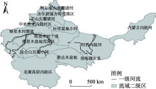
图1
西北诸河流域区位示意图 注:该图基于国家测绘地理信息局标准地图服务网站下载的审图号为GS(2016)2923号的标准地图制作,底图无修改。下同。"

表1
西北诸河流域土地生态安全评价指标体系及权重"
| 目标层 | 准则层 | 权重 | 指标层 | 单位 | 安全趋势 | 权重 | 权重排序 |
|---|---|---|---|---|---|---|---|
| 西北诸河流域土地生态安全评价指标体系 | 压力(P) | 0.2331 | 总人口数 | 104人 | 负向 | 0.0463 | 5 |
| 人口密度 | 人·km-2 | 负向 | 0.0120 | 27 | |||
| 工业废水排放量 | 104 t | 负向 | 0.0293 | 12 | |||
| 工业固体废物产生量 | 104 t | 负向 | 0.0422 | 8 | |||
| 农用化肥施用量 | 104 t | 负向 | 0.0431 | 6 | |||
| 农药使用量 | t | 负向 | 0.0374 | 10 | |||
| 城镇登记失业率 | % | 负向 | 0.0227 | 21 | |||
| 状态(S) | 0.4985 | 水土流失面积 | km2 | 负向 | 0.0277 | 13 | |
| 第一产业增加值 | 108元 | 负向 | 0.0397 | 9 | |||
| 第二产业增加值 | 108元 | 负向 | 0.0428 | 7 | |||
| 第三产业增加值 | 108元 | 正向 | 0.0273 | 14 | |||
| 农业总产值 | 104元 | 正向 | 0.0216 | 23 | |||
| 人均耕地面积 | km2·人-1 | 正向 | 0.0659 | 2 | |||
| 国内生产总值(GDP) | 108元 | 正向 | 0.1486 | 1 | |||
| 城镇化率 | % | 正向 | 0.0247 | 18 | |||
| 城市供水总量 | 104 t | 正向 | 0.0115 | 28 | |||
| 森林覆盖率 | % | 正向 | 0.0266 | 16 | |||
| 湿地面积 | km2 | 正向 | 0.0621 | 3 | |||
| 响应(R) | 0.2684 | 人均GDP | 元·人-1 | 正向 | 0.0252 | 17 | |
| 人均粮食产量 | kg·人-1 | 正向 | 0.0213 | 24 | |||
| 社会消费品零售总额 | 104元 | 正向 | 0.0273 | 15 | |||
| 固定资产投资额 | 104元 | 正向 | 0.0339 | 11 | |||
| 城市生活垃圾清运量 | 104 t | 正向 | 0.0097 | 29 | |||
| 农民人均纯收入 | 元 | 正向 | 0.0245 | 19 | |||
| 有效灌溉面积 | km2 | 正向 | 0.0178 | 25 | |||
| 人工造林面积 | km2 | 正向 | 0.0227 | 22 | |||
| 教育占财政支出比重 | % | 正向 | 0.0475 | 4 | |||
| 城市污水处理率 | % | 正向 | 0.0245 | 20 | |||
| 水土流失治理面积 | km2 | 正向 | 0.0141 | 26 |
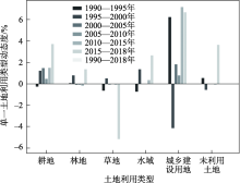
图2
1990—2018年西北诸河流域单一土地利用动态度情况"

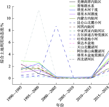
图3
1990—2018年西北诸河流域综合土地利用动态度情况"

表2
1990—2018年西北诸河流域土地利用转移矩阵"
| 1990年 | 2018年 | |||||||
|---|---|---|---|---|---|---|---|---|
| 草地 | 城乡建设用地 | 耕地 | 林地 | 其他未利用土地 | 沙地 | 水域 | 减少量 | |
| 草地 | 914114 | 3398 | 38442 | 26672 | 344630 | 53434 | 31607 | 1412297 |
| 城乡建设用地 | 986 | 2145 | 2858 | 137 | 519 | 27 | 111 | 6783 |
| 耕地 | 13281 | 4374 | 75035 | 1731 | 2086 | 354 | 809 | 97670 |
| 林地 | 23410 | 239 | 3267 | 20148 | 2792 | 1043 | 603 | 51502 |
| 其他未利用土地 | 192445 | 2773 | 12976 | 4780 | 907991 | 23386 | 19712 | 1164063 |
| 沙地 | 20303 | 219 | 2717 | 633 | 26291 | 467289 | 962 | 518414 |
| 水域 | 13937 | 152 | 971 | 586 | 25004 | 680 | 57605 | 98935 |
| 增加量 | 1178476 | 13300 | 136266 | 54687 | 1309313 | 546213 | 111409 | - |
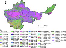
图4
1990—2018年西北诸河流域土地利用变化情况"


图5
1990—2018年西北诸河流域生态安全指数变化情况"

表3
1990—2018年西北诸河流域土地生态安全综合值"
| 年份 | 生态安全指数 | 压力指数 | 状态指数 | 响应指数 | 安全等级 | 安全状态 |
|---|---|---|---|---|---|---|
| 1990 | 0.301 | 0.187 | 0.104 | 0.010 | U | 不安全级 |
| 1991 | 0.293 | 0.182 | 0.103 | 0.009 | U | 不安全级 |
| 1992 | 0.307 | 0.189 | 0.103 | 0.014 | U | 不安全级 |
| 1993 | 0.322 | 0.204 | 0.103 | 0.015 | U | 不安全级 |
| 1994 | 0.318 | 0.196 | 0.104 | 0.017 | U | 不安全级 |
| 1995 | 0.314 | 0.189 | 0.107 | 0.017 | U | 不安全级 |
| 1996 | 0.314 | 0.178 | 0.110 | 0.026 | U | 不安全级 |
| 1997 | 0.319 | 0.180 | 0.112 | 0.027 | U | 不安全级 |
| 1998 | 0.320 | 0.177 | 0.110 | 0.033 | U | 不安全级 |
| 1999 | 0.320 | 0.177 | 0.109 | 0.033 | U | 不安全级 |
| 2000 | 0.304 | 0.173 | 0.095 | 0.035 | U | 不安全级 |
| 2001 | 0.285 | 0.155 | 0.092 | 0.037 | U | 不安全级 |
| 2002 | 0.309 | 0.160 | 0.094 | 0.054 | U | 不安全级 |
| 2003 | 0.313 | 0.161 | 0.088 | 0.064 | U | 不安全级 |
| 2004 | 0.310 | 0.150 | 0.100 | 0.060 | U | 不安全级 |
| 2005 | 0.304 | 0.137 | 0.109 | 0.058 | U | 不安全级 |
| 2006 | 0.308 | 0.131 | 0.111 | 0.066 | U | 不安全级 |
| 2007 | 0.459 | 0.123 | 0.258 | 0.077 | RU | 较不安全级 |
| 2008 | 0.312 | 0.109 | 0.112 | 0.092 | U | 不安全级 |
| 2009 | 0.325 | 0.102 | 0.120 | 0.102 | U | 不安全级 |
| 2010 | 0.351 | 0.080 | 0.122 | 0.149 | U | 不安全级 |
| 2011 | 0.297 | 0.060 | 0.111 | 0.126 | U | 不安全级 |
| 2012 | 0.317 | 0.067 | 0.110 | 0.140 | U | 不安全级 |
| 2013 | 0.434 | 0.055 | 0.224 | 0.155 | RU | 较不安全级 |
| 2014 | 0.366 | 0.039 | 0.163 | 0.164 | U | 不安全级 |
| 2015 | 0.405 | 0.051 | 0.178 | 0.176 | RU | 较不安全级 |
| 2016 | 0.436 | 0.062 | 0.185 | 0.189 | RU | 较不安全级 |
| 2017 | 0.455 | 0.065 | 0.188 | 0.202 | RU | 较不安全级 |
| 2018 | 0.467 | 0.072 | 0.180 | 0.215 | RU | 较不安全级 |
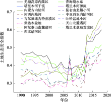
图6
1990—2018年西北诸河流域及水资源二级片区土地生态安全指数变化情况"

| [1] | 李秀彬. 全球环境变化研究的核心领域──土地利用/土地覆被变化的国际研究动向[J]. 地理学报, 1996, 63(6):553-558. |
| [ Li Xiubin. International research trends in land use/land cover change: A core area of global environmental change research[J]. Acta Geographica Sinica, 1996, 63(6):553-558. ] | |
| [2] | 张浚茂, 臧传富. 东南诸河流域1990-2015年土地利用时空变化特征及驱动机制[J]. 生态学报, 2019, 39(24):9339-9350. |
| [ Zhang Junmao, Zang Chuanfu. Spatial and temporal variability characteristics and driving mechanisms of land use in the southeastern river basin from 1990 to 2015[J]. Acta Ecologica Sinica, 2019, 39(24):9339-9350. ] | |
| [3] | 后立胜, 蔡运龙. 土地利用/覆被变化研究的实质分析与进展评述[J]. 地理科学进展, 2004, 23(6):96-104. |
| [ Hou Lisheng, Cai Yunlong. An essential analysis and review on land use/cover change research[J]. Progress in Geography, 2004, 23(6):96-104. ] | |
| [4] | 崔胜辉, 洪华生, 黄云凤, 等. 生态安全研究进展[J]. 生态学报, 2005, 25(4):861-868. |
| [ Cui Shenghui, Hong Huasheng, Huang Yunfeng, et al. Progress of the ecological security research[J]. Acta Ecologica Sinica, 2005, 25(4):861-868. ] | |
| [5] | 李昊, 李世平, 银敏华. 中国土地生态安全研究进展与展望[J]. 干旱区资源与环境, 2016, 30(9):50-56. |
| [ Li Hao, Li Shiping, Yin Minhua. Research progress and prospect of land ecological security in China[J]. Journal of Arid Land Resources and Environment, 2016, 30(9):50-56. ] | |
| [6] | 肖笃宁, 陈文波, 郭福良. 论生态安全的基本概念和研究内容[J]. 应用生态学报, 2002, 13(3):354-358. |
| [ Xiao Duning, Chen Wenbo, Guo Fuliang. On the basic concepts and contents of ecological security[J]. Chinese Journal of Applied Ecology, 2002, 13(3):354-358. ] | |
| [7] | 朱亚楠, 闫志明, 蒲春玲, 等. 乌鲁木齐市土地利用/覆被变化及生态安全评价[J]. 林业资源管理, 2020(1):79-91. |
| [ Zhu Yanan, Yan Zhiming, Pu Chunling, et al. Land use/cover change and ecological security evaluation in Urumqi[J]. Forest Resources Management, 2020(1):79-91. ] | |
| [8] | 余健, 房莉, 仓定帮, 等. 熵权模糊物元模型在土地生态安全评价中的应用[J]. 农业工程学报, 2012, 28(5):260-266. |
| [ Yu Jian, Fang Li, Cang Dingbang, et al. Evaluation of land eco-security in Wanjiang district base on entropy weight and matter element model[J]. Transactions of the Chinese Society of Agricultural Engineering, 2012, 28(5):260-266. ] | |
| [9] | 程东林, 陈英, 乔蕻强, 等. 西北生态脆弱区城市土地生态安全时序性评价--以兰州市为例[J]. 中国国土资源经济, 2020, 33(7):83-89. |
| [ Cheng Donglin, Chen Ying, Qiao Hongqiang, et al. Time series evaluation of urban land eco-security in eco-vulnerable areas of northwest China: A case study of Lanzhou[J]. Natural Resource Economics of China, 2020, 33(7):83-89. ] | |
| [10] | 谢玲, 严土强, 高一薄. 基于PSR模型的广西石漠化地区土地生态安全动态评价[J]. 水土保持通报, 2018, 38(6):315-321. |
| [ Xie Ling, Yan Tuqiang, Gao Yibo. Dynamic evaluation of land ecological security in rocky desertification mountainous area of Guangxi Zhuang Autonomous Region[J]. Bulletin of Soil and Water Conservation, 2018, 38(6):315-321. ] | |
| [11] |
Han B, Liu H, Wang R. Urban ecological security assessment for cities in the Beijing-Tianjin-Hebei metropolitan region based on fuzzy and entropy methods[J]. Ecological Modelling, 2015, 318(1):217-225.
doi: 10.1016/j.ecolmodel.2014.12.015 |
| [12] | 李钊, 张永福, 张景路. 干旱区绿洲县域土地利用规划中土地生态安全预测--以新疆阿瓦提县为例[J]. 水土保持研究, 2014, 21(6):148-151, 157. |
| [ Li Zhao, Zhang Yongfu, Zhang Jinglu. Forecast of the land ecological security at county level in the arid oasis based on planning of land utilization: A case study of Awati in Xinjiang[J]. Research of Soil and Water Conservation, 2014, 21(6):148-151, 157. ] | |
| [13] | 李玉照, 刘永, 颜小品. 基于DPSIR模型的流域生态安全评价指标体系研究[J]. 北京大学学报(自然科学版), 2012, 48(6):971-981. |
| [ Li Yuzhao, Liu Yong, Yan Xiaopin. A DPSIR-based indicator system for ecological security assessment at the basin scale[J]. Journal of Peking University (Natural Science Edition), 2012, 48(6):971-981. ] | |
| [14] | 李晓文, 方创琳, 黄金川, 等. 西北干旱区城市土地利用变化及其区域生态环境效应--以甘肃河西地区为例[J]. 第四纪研究, 2003, 23(3): 280-290, 348-349. |
| [ Li Xiaowen, Fang Chuanglin, Huang Jinchuan, et al. The urban land use transformations and associated effects on eco-environment in northwest China arid region: A case study in Hexi Region, Gansu Province[J]. Quaternary Sciences, 2003, 23(3): 280-290, 348-349. ] | |
| [15] | 李春燕, 南灵. 陕西省土地生态安全动态评价及障碍因子诊断[J]. 中国土地科学, 2015, 29(4):72-81. |
| [ Li Chunyan, Nan Ling. Dynamic evaluation and diagnosis of obstacle factors on land eco-security in Shaanxi Province[J]. China Land Science, 2015, 29(4):72-81. ] | |
| [16] | 张小虎, 雷国平, 袁磊, 等. 黑龙江省土地生态安全评价[J]. 中国人口·资源与环境, 2009, 19(1):88-93. |
| [ Zhang Xiaohu, Lei Guoping, Yuan Lei, et al. Evaluation on ecological security of land based on entropy weight and matter-element model: A case study of Heilongjiang Province[J]. China Population, Resources and Environment, 2009, 19(1):88-93. ] | |
| [17] |
Gong J Z, Liu Y S, Xia B C, et al. Urban ecological security assessment and forecasting, based on a cellular automata model: A case study of Guangzhou, China[J]. Ecological Modelling, 2009, 220(24):3612-3620.
doi: 10.1016/j.ecolmodel.2009.10.018 |
| [18] |
朱会义, 李秀彬, 何书金, 等. 环渤海地区土地利用的时空变化分析[J]. 地理学报, 2001, 56(3):253-260.
doi: 10.11821/xb200103001 |
|
[ Zhu Huiyi, Li Xiubin, He Shujin, et al. Spatio-temporal change of land use in Bohai Rim[J]. Acta Geographica Sinica, 2001, 56(3):253-260. ]
doi: 10.11821/xb200103001 |
|
| [19] | 马新萍, 韩申山, 王磊, 等. 大西安地区土地利用类型时空演变分析[J]. 干旱区地理, 2020, 43(2):499-507. |
| [ Ma Xinping, Han Shenshan, Wang Lei, et al. Spatial and temporal evolution of land use types in the Greater Xi’an Area[J]. Arid Land Geography, 2020, 43(2):499-507. ] | |
| [20] | 张一达, 刘学录, 范亚红, 等. 基于改进TOPSIS法的兰州市土地利用多功能性评价[J]. 干旱区地理, 2019, 42(2):444-451. |
| [ Zhang Yida, Liu Xuelu, Fan Yahong, et al. Multi-functional evaluation on land use in Lanzhou City based on the improved TOPSIS[J]. Arid Land Geography, 2019, 42(2):444-451. ] | |
| [21] | 庞雅颂, 王琳. 区域生态安全评价方法综述[J]. 中国人口·资源与环境, 2014, 24(163):340-344. |
| [ Pang Yasong, Wang Lin. A review of regional ecological security evaluation[J]. China Population, Resources and Environment, 2014, 24(163):340-344. ] | |
| [22] | 杨春红, 张正栋, 田楠楠, 等. 基于P-S-R模型的汕头市土地生态安全评价[J]. 水土保持研究, 2012, 19(3):209-214. |
| [ Yang Chunhong, Zhang Zhengdong, Tian Nannan, et al. Evaluation on land ecological security in Shantou based on P-S-R model[J]. Research of Soil and Water Conservation, 2012, 19(3):209-214. ] | |
| [23] | 麦丽开·艾麦提, 满苏尔·沙比提, 张雪琪, 等. 叶尔羌河平原绿洲土地利用变化及土地生态安全评价研究[J]. 土壤, 2019, 51(4):795-802. |
| [ Aimaiti Mailikai, Shabiti Mansuer, Zhang Xueqi, et al. Study on land use change and land ecological security evaluation in oasis of Yarkant River Plain[J]. Soil, 2019, 51(4):795-802. ] | |
| [24] | 徐新良, 庄大方, 贾绍凤, 等. GIS环境下基于DEM的中国流域自动提取方法[J]. 长江流域资源与环境, 2004, 13(4):343-348. |
| [ Xu Xinliang, Zhuang Dafang, Jia Shaofeng, et al. Automated extraction of drainages in China based on DEM in GIS environment[J]. Resources and Environment in the Yangtze Basin, 2004, 13(4):343-348. ] | |
| [25] | 张国平, 赵琳娜, 许凤雯, 等. 基于流域结构分析的中国流域划分方案[J]. 北京师范大学学报(自然科学版), 2010, 46(3):417-423. |
| [ Zhang Guoping, Zhao Linna, Xu Fengwen, et al. Study on basin partition scheme of China based on basin structure analysis[J]. Journal of Beijing Normal University (Natural Science Edition), 2010, 46(3):417-423. ] | |
| [26] | 杨艳春, 彭勃, 刘桂丽, 等. 西北诸河区地表水水质评价[J]. 人民黄河, 2011, 33(11):93-96. |
| [ Yang Yanchun, Peng Bo, Liu Guili, et al. Quality evaluation of surface water in the northwest region[J]. Yellow River, 2011, 33(11):93-96. ] | |
| [27] | 王秀兰, 包玉海. 土地利用动态变化研究方法探讨[J]. 地理科学进展, 1999(1):3-5. |
| [ Wang Xiulan, Bao Yuhai. Study on the methods of land use dynamic change research[J]. Progress in Geography, 1999(1):3-5. ] | |
| [28] |
Wolfslehner B, Vacik H. Evaluating sustainable forest management strategies with the analytic network process in a pressure-state-response framework[J]. Journal of Environmental Management, 2008, 88(1):1-10.
pmid: 17418934 |
| [29] | 刘凌冰, 李世平. 西北荒漠化地区土地生态安全评价--以酒泉市为例[J]. 水土保持研究, 2014, 21(4):190-194, 202. |
| [ Liu lingbing, Li Shiping. Evaluation on land ecological security in desertification areas of northwest China: A case study of Jiuquan City[J]. Research of Soil and Water Conservation, 2014, 21(4):190-194, 202. ] | |
| [30] | 裴婷婷, 陈英, 赵亚南, 等. 基于P-S-R模型的白银市土地生态安全评价[J]. 中国农学通报, 2014, 30(2):215-221. |
| [ Pei Tingting, Chen Ying, Zhao Yanan, et al. Evaluation on the ecological security of Baiyin City based on P-S-R model[J]. Chinese Agricultural Science Bulletin, 2014, 30(2):215-221. ] | |
| [31] |
Wang C L, Jiang Q O, Shao Y Q, et al. Ecological environment assessment based on land use simulation: A case study in the Heihe River Basin[J]. Science of the Total Environment, 2019, 697:133928, doi: 10.1016/j.scitotenv.2019.133928.
doi: 10.1016/j.scitotenv.2019.133928 |
| [32] |
Pei L, Du L M, Yue G J. Ecological security assessment of Beijing based on PSR model[J]. Procedia Environmental Sciences, 2010, 2:832-841.
doi: 10.1016/j.proenv.2010.10.094 |
| [33] |
Ye H, Ma Y, Dong L M. Land ecological security assessment for Bai Autonomous Prefecture of Dali based using PSR model with data in 2009 as case[J]. Energy Procedia, 2011, 5:2172-2177.
doi: 10.1016/j.egypro.2011.03.375 |
| [34] | 苏为华. 多指标综合评价理论与方法问题研究[D]. 厦门: 厦门大学, 2000. |
| [ Su Weihua. Research on the theory and method of multi index comprehensive evaluation[D]. Xiamen: Xiamen University, 2000. ] | |
| [35] | 陈伊多, 杨庆媛, 杨人豪, 等. 基于熵权物元模型的土地生态安全评价--重庆市江津区实证[J]. 干旱区地理, 2018, 41(1):185-194. |
| [ Chen Yiduo, Yang Qingyuan, Yang Renhao, et al. Evaluation of land ecological security based on entropy weighted matter-element model: A case of Jiangjin District, Chongqing[J]. Arid Land Geography, 2018, 41(1):185-194. ] | |
| [36] | 陈东景, 徐中民. 西北内陆河流域生态安全评价研究--以黑河流域中游张掖地区为例[J]. 干旱区地理, 2002, 25(3):219-224. |
| [ Chen Dongjing, Xu Zhongmin. Study on assessment of the ecological security in the continental watersheds in northwest China: A case study at the middle reaches of Heihe River Watershed, Zhangye Prefecture[J]. Arid Land Geography, 2002, 25(3):219-224. ] | |
| [37] |
Shi X Q, Zhao J Z, Ouyang Z Y. Assessment of eco-security in the knowledge grid e-science environment[J]. Journal of Systems and Software, 2005, 79(2):246-252.
doi: 10.1016/j.jss.2005.04.031 |
| [38] | 朱亚楠, 蒲春玲. 乌鲁木齐市土地利用景观格局变化及生态安全分析[J]. 生态科学, 2020, 39(2):133-144. |
| [ Zhu Yanan, Pu Chunling. Analysis on landscape pattern change and ecological security of land use in Urumqi[J]. Ecological Science, 2020, 39(2):133-144. ] | |
| [39] | 李小玉, 肖笃宁. 石羊河流域中下游绿洲土地利用变化与水资源动态研究[J]. 水科学进展, 2005, 16(5):643-648. |
| [ Li Xiaoyu, Xiao Duning. Dynamics of water resources and land use in oases in middle and lower reaches of Shiyang River Watershed, northwest China[J]. Advances in Water Science, 2005, 16(5):643-648. ] | |
| [40] | 冯异星, 罗格平, 尹昌应, 等. 干旱区内陆河流域土地利用程度变化与生态安全评价--以新疆玛纳斯河流域为例[J]. 自然资源学报, 2009, 24(11):1921-1932. |
| [ Feng Yixing, Luo Geping, Yin Changying, et al. Change of land-use degree and ecological security assessment of inland river basins in the arid area: A case study on Manas River Basin in Xinjiang[J]. Journal of Natural Resources, 2009, 24(11):1921-1932. ] | |
| [41] | 王一航, 夏沛, 刘志锋, 等. 中国绿洲城市土地利用/覆盖变化研究进展[J]. 干旱区地理, 2019, 42(2):341-353. |
| [ Wang Yihang, Xia Pei, Liu Zhifeng, et al. Research progress of urban land use/cover change in the oasis cities of China[J]. Arid Land Geography, 2019, 42(2):341-353. ] | |
| [42] | 岳耀杰, 周洪建, 王静爱, 等. 生态安全条件下亚洲沙区土地利用结构研究[J]. 地球科学进展, 2006, 21(2):131-137. |
| [ Yue Yaojie, Zhou Hongjian, Wang Jingai, et al. Research on the land use structure of Asian desert regions at ecological security level[J]. Advances in Earth Science, 2006, 21(2):131-137. ] | |
| [43] | 李智国, 杨子生. 中国土地生态安全研究进展[J]. 中国安全科学学报, 2007, 17(12):5-12, 197. |
| [ Li Zhiguo, Yang Zisheng. Research progress of land ecological security in China[J]. China Safety Science Journal, 2007, 17(12):5-12, 197. ] |
| [1] | 王一山,张飞,陈瑞,齐亚霄,刘长江. 乌鲁木齐市土地生态安全综合评价[J]. 干旱区地理, 2021, 44(2): 427-440. |
| [2] | 郑岚,张志斌,笪晓军,马亚兄. 嘉峪关市土地生态安全动态评价及影响因素分析[J]. 干旱区地理, 2021, 44(1): 289-298. |
| [3] | 王晶, 原伟鹏, 刘新平. 哈尔滨城市土地生态安全时序评价及预测分析[J]. 干旱区地理, 2018, 41(4): 885-892. |
| [4] | 马轩凯, 高敏华. 西北干旱地区绿洲城市土地生态安全动态评价——以新疆库尔勒市为例[J]. 干旱区地理, 2017, 40(1): 172-180. |
| [5] | 丁新原,周智彬,马守臣,甘萍. 矿粮复合区土地生态安全评价——以焦作市为例[J]. 干旱区地理, 2013, 36(6): 1067-1075. |
| [6] | 丁建国,刘晓媛,戴健,苏武峥,陆朝晖,李苗. 模糊综合评价法在新疆农业主导功能定位中的应用[J]. 干旱区地理, 2012, 35(04): 678-686. |
| Viewed | ||||||||||||||||||||||||||||||||||||||||||||||||||
|
Full text 97
|
|
|||||||||||||||||||||||||||||||||||||||||||||||||
|
Abstract 494
|
|
|||||||||||||||||||||||||||||||||||||||||||||||||
Cited |
|
|||||||||||||||||||||||||||||||||||||||||||||||||
| Shared | ||||||||||||||||||||||||||||||||||||||||||||||||||
|
||