| [1] |
申元村, 汪久文, 伍光和, 等. 中国绿洲[M]. 开封: 河南大学出版社, 2001.
|
|
[Shen Yuancun, Wang Jiuwen, Wu Guanghe, et al. Oasis of China[M]. Kaifeng: Henan University Press, 2001.]
|
| [2] |
吕利利, 颉耀文, 张秀霞, 等. 1986—2015年瓜州绿洲变化[J]. 生态学报, 2017, 37(16): 5482-5491.
|
|
[Lü Lili, Xie Yaowen, Zhang Xiuxia, et al. Changes in Guazhou oases between 1986 and 2015[J]. Acta Ecologica Sinica, 2017, 37(16): 5482-5491.]
|
| [3] |
Chen P, Wang S, Liu Y X, et al. Spatio-temporal dynamics of aboveground biomass in China's oasis grasslands between 1989 and 2021[J]. Earth's Future, 2024, 12(3): e2023EF003944, doi: 10.1029/2023EF003944.
|
| [4] |
Yi F, Lu Q, Li Y H, et al. Ecological vulnerability assessment of natural oasis in arid areas: Application to Dunhuang, China[J]. Ecological Indicators, 2023, 149: 110139, doi: 10.1016/j.eco-lind.2023.110139.
|
| [5] |
张齐飞, 陈亚宁, 孙从建, 等. 塔里木河流域水储量变化及绿洲生态安全评估[J]. 干旱区地理, 2024, 47(1): 1-14.
doi: 10.12118/j.issn.1000-6060.2023.247
|
|
[Zhang Qifei, Chen Yaning, Sun Congjian, et al. Changes in terrestrial water storage and evaluation of oasis ecological security in the Tarim River Basin[J]. Arid Land Geoghraphy, 2024, 47(1): 1-14.]
|
| [6] |
Chen Y N, Fang G H, Li Z, et al. The crisis in oases: Research on ecological security and sustainable development in arid regions[J]. Annual Review of Environment and Resources, 2024, 49: 1-20.
|
| [7] |
Sun F, Wan Y, Chen Y N, et al. Historic and simulated desert-oasis ecotone changes in the arid Tarim River Basin, China[J]. Remote Sensing, 2021, 13(4): 647, doi: 10.3390/rs13040647.
|
| [8] |
Xie Y C, Gong J, Sun P, et al. Oasis dynamics change and its influence on landscape pattern on Jinta oasis in arid China from 1963a to 2010a: Integration of multi-source satellite images[J]. International Journal of Applied Earth Observation and Geoinformation, 2014, 33: 181-191.
|
| [9] |
张秀霞, 颉耀文, 卫娇娇, 等. 1986—2015年干旱区敦煌绿洲景观的时空演变过程[J]. 干旱区研究, 2017, 34(3): 669-676.
|
|
[Zhang Xiuxia, Xie Yaowen, Wei Jiaojiao, et al. Spatiotemporal evolution of landscapes in the arid Dunhuang oasis during the period of 1986—2015[J]. Arid Zone Research, 2017, 34(3): 669-676.]
|
| [10] |
Deng X Z, Zhao C H, Lin Y Z, et al. Downscaling the impacts of large-scale LUCC on surface temperature along with IPCC RCPs: A global perspective[J]. Energies, 2014, 7: 2720-2739.
|
| [11] |
孙旭伟, 李森, 王亚晖, 等. 1975—2020 年疏勒河流域绿洲时空变化研究[J]. 生态学报, 2022, 42(22): 9111-9120.
|
|
[Sun Xuwei, Li Sen, Wang Yahui, et al. Spatiotemporal change of oasis in Shule River Basin during 1975—2020[J]. Acta Ecologica Sinica, 2022, 42(22): 9111-9120.]
|
| [12] |
巩杰, 谢余初, 孙朋, 等. 乡镇尺度金塔绿洲时空格局变化[J]. 生态学报, 2013, 33(11): 3470-3479.
|
|
[Gong Jie, Xie Yuchu, Sun Peng, et al. Spatio-temporal change on township scale of Jinta oasis in the latest 20 years[J]. Acta Ecologica Sinica, 2013, 33(11): 3470-3479.]
|
| [13] |
Chen Y, Yang G J, Zhou L H, et al. Quantitative analysis of natural and human factors of oasis change in the tail of Shiyang River over the past 60 years[J]. Acta Geologica Sinica, 2020, 94(3): 637-645.
|
| [14] |
李梦怡, 邓铭江, 凌红波, 等. 新疆绿洲格局变化与生态耗水结构分析[J]. 水科学进展, 2023, 34(5): 719-730.
|
|
[Li Mengyi, Deng Mingjiang, Ling Hongbo, et al. Analysis on the change of oasis pattern and ecological water consumption structure in Xinjiang[J]. Advamces in Water Science, 2023, 34(5): 719-730.]
|
| [15] |
Mo K L, Chen Q W, Chen C, et al. Spatiotemporal variation of correlation between vegetation cover and precipitation in an arid mountain-oasis river basin in northwest China[J]. Journal of Hydrology, 2019, 574: 138-147.
|
| [16] |
Amuti T, Luo G. Analysis of land cover change and its driving forces in a desert oasis landscape of Xinjiang, northwest China[J]. Solid Earth, 2014, 5(2): 1071-1085.
|
| [17] |
Bie Q, Xie Y W. The constraints and driving forces of oasis development in arid region: A case study of the Hexi Corridor in northwest China[J]. Scientific Reports, 2020, 10(1): 17708, doi: 10.1038/s41598-020-74930-z.
|
| [18] |
Chen Y N, Chen Z S. Analysis of oasis evolution and suitable development scale for arid regions: A case study of the Tarim River Basin[J]. Chinese Journal of Eco-Agriculture, 2013, 21(1): 134-140.
|
| [19] |
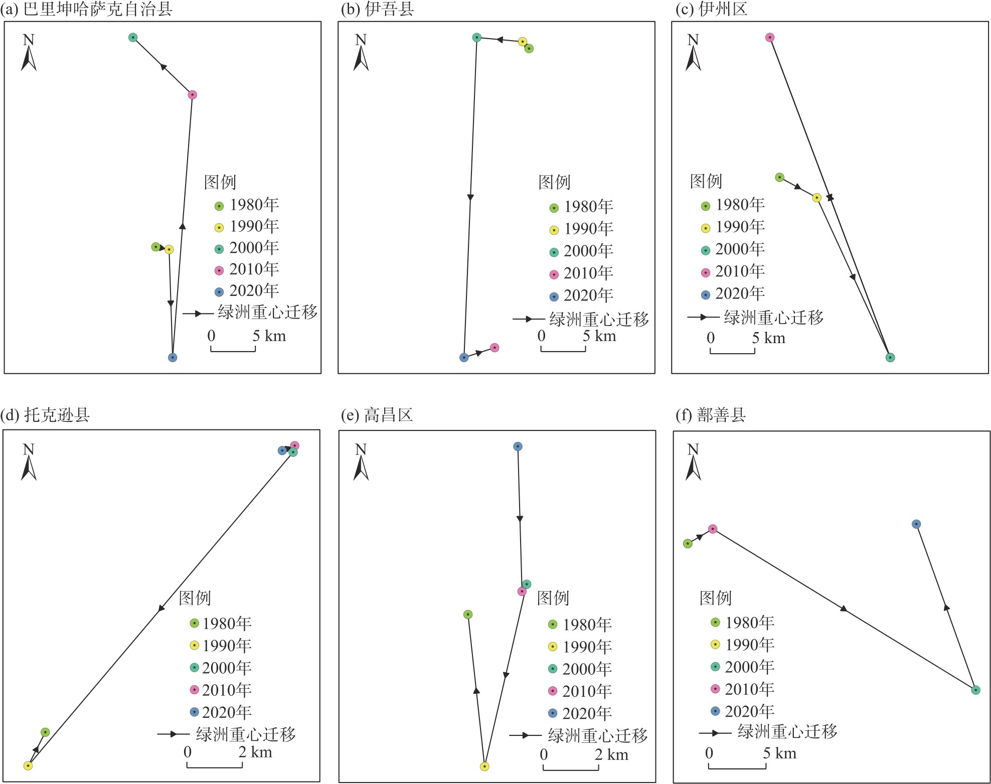
刘亚文, 阿不都沙拉木·加拉力丁, 阿拉努尔·艾尼娃尔, 等. 1989—2016年吐鲁番高昌区绿洲时空格局变化及其驱动因素[J]. 干旱区研究, 2018, 35(4): 945-953.
|
|
[Liu Yawen, Jalaliding Abdushalam, Aniwaer Alanuer, et al. Spatiotemporal change of the oasis in Gaochang, Turpan and its driving factors during the period of 1989—2016[J]. Arid Zone Research, 2018, 35(4): 945-953.]
|
| [20] |
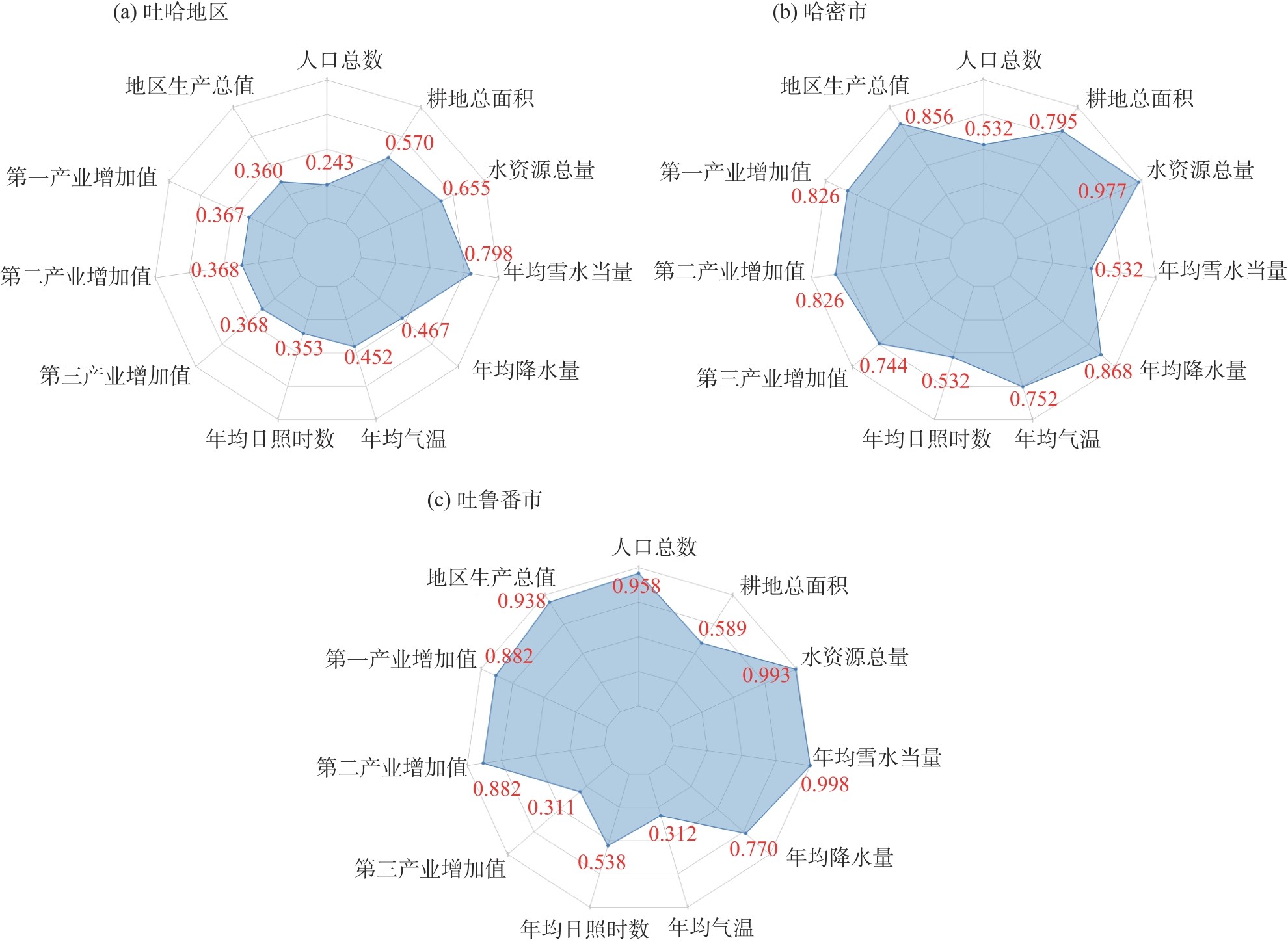
胡金虎, 丁建丽, 张子鹏, 等. 近30年吐鲁番哈密地区植被生态需水估算[J]. 生态学报, 2024, 44(19): 8699-8715.
|
|
[Hu Jinhu, Ding Jianli, Zhang Zipeng, et al. Estimation of vegetation ecological water demand in Tuha area in the past 30 years[J]. Acta Ecologica Sinica, 2024, 44(19): 8699-8715.]
|
| [21] |
袁乐, 阿不都克依木·阿布力孜, 于苏云江·吗米提敏, 等. 基于生态系统服务簇的生态功能区权衡与协同关系演变: 以吐哈地区为例[J]. 环境科学, 2025, 46(5): 3042-3057.
|
|
[Yuan Le, Abulizi Abudukeyimu, Mamitimin Yusuyunjiang, et al. Evolution trade-offs and synergistic relationships in ecological functional areas based on ecosystem service bundles: A case study of the Turpan-Hami region[J]. Environmental Science, 2025, 46(5): 3042-3057.]
|
| [22] |
傅楷翔, 贾国栋, 余新晓, 等. 基于改进遥感生态指数的吐鲁番-哈密地区生态环境质量评价及驱动机制分析[J]. 生态学报, 2024, 44(9): 3911-3923.
|
|
[Fu Kaixiang, Jia Guodong, Yu Xinxiao, et al. Evaluation of ecological environment quality and analysis of driving mechanism in Tulufan-Hami region based on improved remote sensing ecological indices[J]. Acta Ecologica Sinica, 2024, 44(9): 3911-3923.]
|
| [23] |
王瑾杰, 丁建丽, 张子鹏. 基于遥感生态指数的吐哈地区生态环境变化研究[J]. 干旱区地理, 2022, 45(5): 1591-1603.
doi: 10.12118/j.issn.1000-6060.2022.346
|
|
[Wang Jinjie, Ding Jianli, Zhang Zipeng. Change of ecological environment in Turpan and Hami cities based on remote sensing ecology index[J]. Arid Land Geoghraphy, 2022, 45(5): 1591-1603.]
|
| [24] |
刘纪远. 中国资源环境遥感宏观调查与动态研究[M]. 北京: 中国科学技术出版社, 1996.
|
|
[Liu Jiyuan. Macro-scale survey and dynamic study of natural resources and environment of China by remote sensing[M]. Beijing: China Science and Technology Press, 1996.]
|
| [25] |
谢余初, 巩杰, 钱大文. 绿洲时空变化数量方法的述评[J]. 干旱区研究, 2015, 32(6): 1247-1254.
|
|
[Xie Yuchu, Gong Jie, Qian Dawen. Discussion of quantitative methods on oasis spatio-temporal change[J]. Arid Zone Research, 2015, 32(6): 1247-1254.]
|
| [26] |
朱会义, 李秀彬. 关于区域土地利用变化指数模型方法的讨论[J]. 地理学报, 2003, 58(5): 643-650.
|
|
[Zhu Huiyi, Li Xiubin. Disscion on the index method of regional land use change[J]. Acta Geographycia Sinca, 2003, 58(5): 643-650.]
|
| [27] |
巩杰, 孙朋, 谢余初, 等. 基于移动窗口法的肃州绿洲化与景观破碎化时空变化[J]. 生态学报, 2015, 35(19): 6470-6480.
|
|
[Gong Jie, Sun Peng, Xie Yuchu, et al. Spatiotemporal change and landscape fragmentation in Suzhou oasis using the moving window method[J]. Acta Ecologica Sinica, 2015, 35(19): 6470-6480.]
|
| [28] |
李军豪, 陈勇, 杨国靖, 等. 1975—2018年民勤绿洲沙漠化过程及其驱动机制[J]. 中国沙漠, 2021, 41(3): 44-55.
doi: 10.7522/j.issn.1000-694X.2021.00014
|
|
[Li Junhao, Chen Yong, Yang Guojing, et al. The aeolian desertification process and driving mechanism of Minqin oasis from 1975 to 2018[J]. Journal of Desert Research, 2021, 41(3): 44-55.]
doi: 10.7522/j.issn.1000-694X.2021.00014
|
| [29] |
Wang X Y, Wang W H, Yan C, et al. Driving effects of spatiotemporal evolution of the water resources carrying capacity in the Yellow River Basin (Henan section)[J]. Scientific Reports, 2024, 14(1): 29340, doi: 10.1038/s41598-024-80291-8.
|
| [30] |
卢调雪, 杨林山, 冯起, 等. 近20年张掖盆地绿洲结构和规模变化及其影响因素[J]. 中国沙漠, 2023, 43(6): 131-141.
doi: 10.7522/j.issn.1000-694X.2023.00053
|
|
[Lu Diaoxue, Yang Linshan, Feng Qi, et al. The change of oasis structure/scale and its influencing factors in Zhangye Basin in recent 20 years[J]. Journal of Desert Research, 2023, 43(6): 131-141.]
|
| [31] |
Ha L, Tu J J, Yang J P, et al. Regional eco-efficiency evaluation and spatial pattern analysis of the Yangtze River Economic Zone[J]. Journal of Geographical Sciences, 2020, 30(7): 1117-1139.
doi: 10.1007/s11442-020-1773-0
|
| [32] |
Zhang Q L, Yan M, Zhang L, et al. Three decades of oasis transition and its driving factors in Turpan-Hami Basin in Xinjiang, China: A complex network approach[J]. Remote Sensing, 2024, 16: 465, doi: 10.3390/rs16030465.
|
| [33] |
王子元, 管仪庆, 张丹蓉, 等. 1991—2020年新疆艾丁湖面积时空变化分析[J]. 水电能源科学, 2022, 40(10): 35-38.
|
|
[Wang Ziyuan, Guan Yiqing, Zhang Danrong, et al. Analysis of spatiotemporal variation of Aiding Lake area in Xinjiang during 1991 and 2020[J]. Water Resources and Power, 2022, 40(10): 35-38.]
|
| [34] |
龚晓菊, 申亚杰. 天山北坡城市群产业协同发展分析[J]. 经济研究参考, 2017(37): 55-64.
|
|
[Gong Xiaoju, Shen Yajie. Analysis on the coordinated development of industries in the urban agglomeration on the northern slope of Tianshan Mountains[J]. Riview of Economic Research, 2017(37): 55-64.]
|
| [35] |
韩楚翘, 郑江华, 王哲, 等. 基于PLUS-InVEST模型吐哈盆地陆地生态系统碳储量时空变化及多情景模拟[J]. 干旱区地理, 2024, 47(2): 260-269.
|
|
[Han Chuqiao, Zheng Jianghua, Wang Zhe, et al. Spatiotemporal variation and multiscenario simulation of carbon storage in terrestrial ecosystems in the Turpan-Hami Basin based on PLUS-InVEST model[J]. Arid Land Geography, 2024, 47(2): 260-269.]
doi: 10.12118/j.issn.1000-6060.2023.066
|
| [36] |
焦岩, 闫峰, 卢琦, 等. 西北干旱区绿洲时空变化及驱动力[J]. 应用生态学报, 2024, 35(8): 2206-2216.
doi: 10.13287/j.1001-9332.202408.025
|
|
[Jiao Yan, Yan Feng, Lu Qi, et al. Spatiotemporal variation and driving factors of oases in the arid region of northwest China[J]. Chinese Journal of Applied Ecology, 2024, 35(8): 2206-2216.]
doi: 10.13287/j.1001-9332.202408.025
|
| [37] |
周孝明, 张喆, 张越, 等. 基于TVDI的近20 a吐鲁番市干旱及影响因素分析[J]. 干旱区地理, 2024, 47(12): 2104-2114.
doi: 10.12118/j.issn.1000-6060.2024.234
|
|
[Zhou Xiaoming, Zhang Zhe, Zhang Yue, et al. TVDI-based analysis of drought and influencing factors in Turpan City in the last 20 years[J]. Arid Land Geography, 2024, 47(12): 2104-2114.]
doi: 10.12118/j.issn.1000-6060.2024.234
|
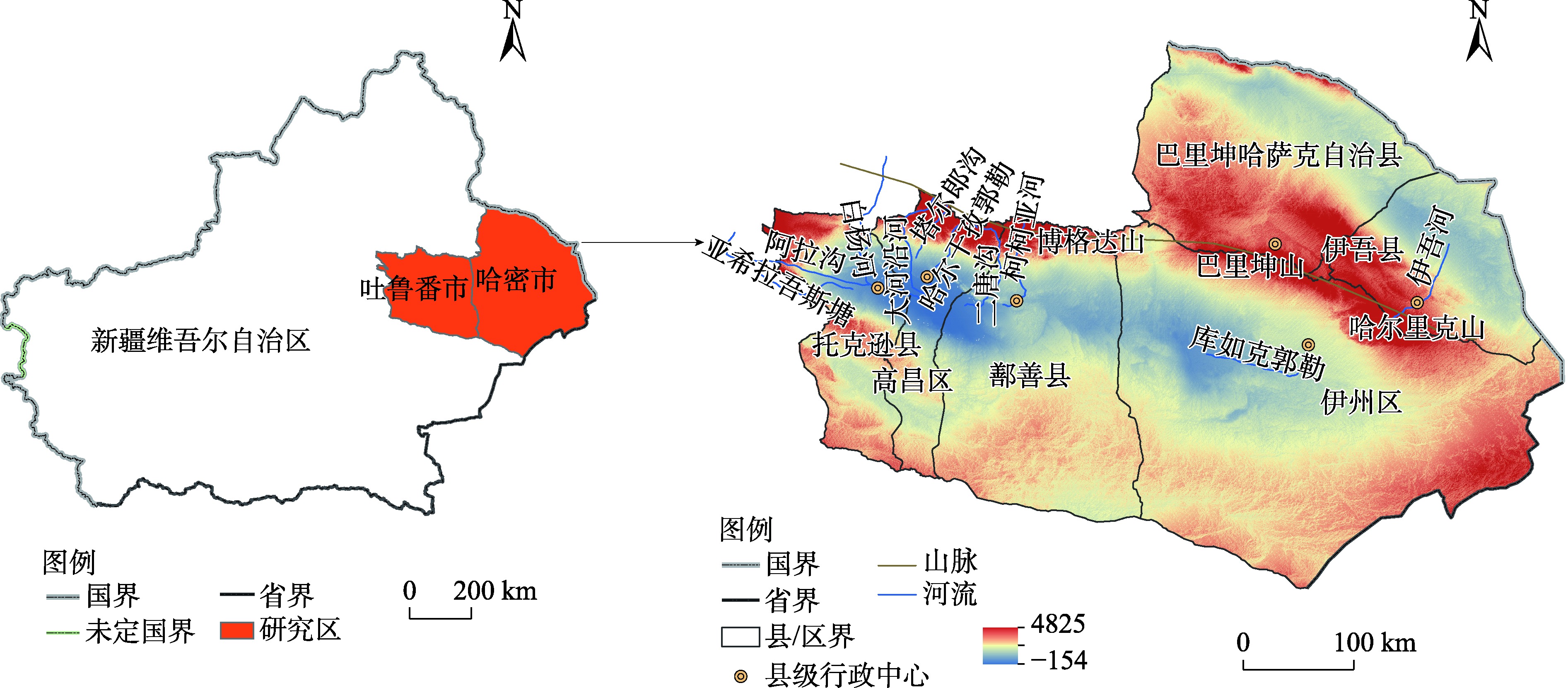
 ), 党若源1,2, 杨舒喻3, 王蕾4, 徐基良1,2, 李景文1,2, 安黎哲1,2(