干旱区地理 ›› 2023, Vol. 46 ›› Issue (1): 11-22.doi: 10.12118/j.issn.1000-6060.2022.165 cstr: 32274.14.ALG2022165
张娟( ),姚晓军(),李净,王晓燕
收稿日期:2022-04-19
修回日期:2022-07-05
出版日期:2023-01-25
发布日期:2023-02-21
作者简介:张娟(1998-),女,在读博士,主要从事干旱演变及响应研究. E-mail: 基金资助:
ZHANG Juan(),YAO Xiaojun(),LI Jing,WANG Xiaoyan
Received:2022-04-19
Revised:2022-07-05
Published:2023-01-25
Online:2023-02-21
摘要:
干旱是农作物生长发育的主要环境胁迫因子,也是制约农业丰产丰收的关键自然要素。农业干旱监测通常基于气象站点观测数据,这在一定程度上难以反映区域尺度的农业干旱状况。以甘肃省为研究区,基于MODIS、TRMM、ESA CCI等遥感数据产品和气象站点数据,利用随机森林回归模型构建综合气象干旱指数(CMDI),并对甘肃省2011—2019年农作物生长季(4—9月)旱情时空格局及变化规律进行分析。结果表明:(1) CMDI与实测值的决定系数(R2)在各月均高于0.634,且与标准化降水蒸散发指数(SPEI)在空间上具有一定的相关性,表明该指数可反映农业干旱的发生发展过程。(2) 甘肃省农业干旱呈现明显的地域分异规律,干旱程度由东南向西北逐渐加重,其中河西地区多为特旱区和重旱区,陇中地区为重(中)旱区,陇南、陇东、甘南地区为干旱-无旱波动变化区。(3) 2011—2019年甘肃省农业干旱在年、月尺度上均呈现较大的波动趋势,其中2012年干旱程度最轻,2017年则最为严重;甘肃省大部分地区在4月和6月,陇东、陇南地区分别在5月和9月以及甘南地区4—9月农业旱情有所减轻外,其余地区在农作物生长季的旱情呈加重趋势。
张娟, 姚晓军, 李净, 王晓燕. 基于多源遥感数据的甘肃省农业干旱研究[J]. 干旱区地理, 2023, 46(1): 11-22.
ZHANG Juan, YAO Xiaojun, LI Jing, WANG Xiaoyan. Agricultural drought research based on multi-source remote sensing data in Gansu Province[J]. Arid Land Geography, 2023, 46(1): 11-22.

图1
甘肃省农业分区 注:该图基于国家测绘地理信息局标准地图服务网站下载的审图号为GS(2020)4630号的标准地图制作,底图边界无修改。下同。"
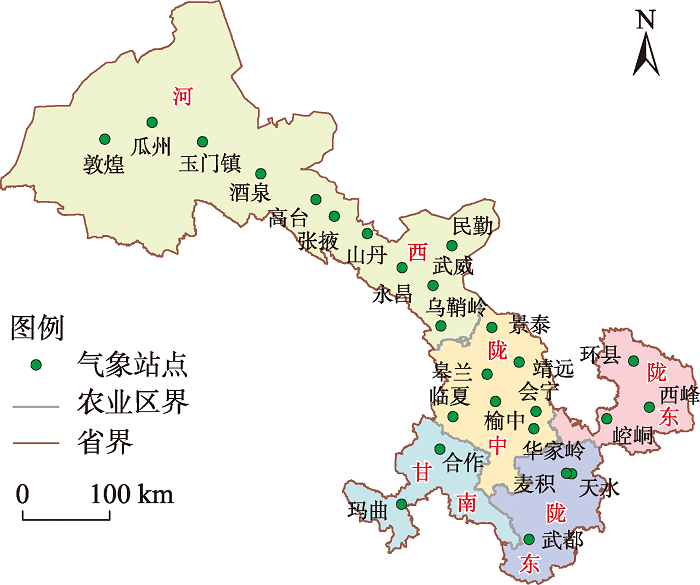
表1
干旱指数计算方法"
| 干旱指数 | 计算公式 | 符号含义 |
|---|---|---|
| 植被状态指数(VCI) | NDVI为归一化植被指数;NDVImax、NDVImin分别为某月归一化植被指数的最大值和最小值。 | |
| 温度状态指数(TCI) | LST为地表温度即地面的温度(℃);LSTmax、LSTmin分别为某月地表温度的最高值和最低值(℃)。 | |
| 降水状态指数(PCI) | TRMM为卫星降水数据,表征降水量的大小(mm·h-1);TRMMmax、TRMMmin分别为某月降水量的最大值和最小值(mm) | |
| 土壤湿度状态指数(SMCI) | SM为土壤湿度;SMmax、SMmin分别为某月土壤湿度的最大值和最小值。 | |
| 温度植被干旱指数(TVDI) | ||
| 微波综合干旱指数(MIDI) | α、β分别为PCI、TCI的权重值。 |
表2
综合气象干旱指数(CMDI)及标准化降水蒸散发指数(SPEI)干旱等级划分"
| 等级 | 类型 | 综合气象干旱指数 | 标准化降水蒸散发指数 |
|---|---|---|---|
| 1 | 无旱 | -0.6<CMDI | -0.5<SPEI |
| 2 | 轻旱 | -1.2<CMDI≤-0.6 | -1.0<SPEI≤-0.5 |
| 3 | 中旱 | -1.8<CMDI≤-1.2 | -1.5<SPEI≤-1.0 |
| 4 | 重旱 | -2.4<CMDI≤-1.8 | -2.0<SPEI≤-1.5 |
| 5 | 特旱 | CMDI≤-2.4 | SPEI≤-2.0 |
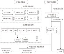
图2
随机森林模型构建流程图 注:MOD13A2为植被指数产品归一化植被指数(NDVI);MOD11A2为地表温度(LST)产品;MCD12Q1为2015年土地覆盖类型产品;TRMM 3B43为降水数据;SRTM DEM为地形数据;ESA CCI为土壤湿度数据;DEM、SLOPE、ASPECT为高程、坡度、坡向;VCI为植被状态指数;TCI为温度状态指数;PCI为降水状态指数;SMCI为土壤湿度状态指数;TVDI为温度植被干旱指数;MIDI为微波综合干旱指数;CMDI为综合气象干旱指数;SPEI为标准化降水蒸散发指数。下同。"
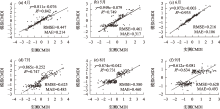
图3
4—9月模拟CMDI与气象站点实测CMDI散点图 注:RMSE为均方根误差;MAE为平均绝对误差。"
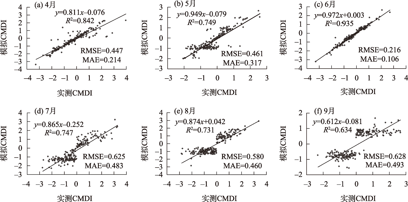

图4
4—9月模拟CMDI与SPEI的空间相关性"

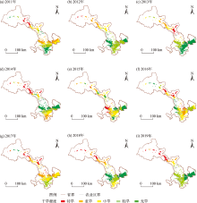
图5
2011—2019年甘肃省农业干旱程度"

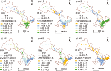
图6
2011—2019年4—9月甘肃省农业干旱变化趋势"


图7
2011—2019年4—9月模拟CMDI均值"
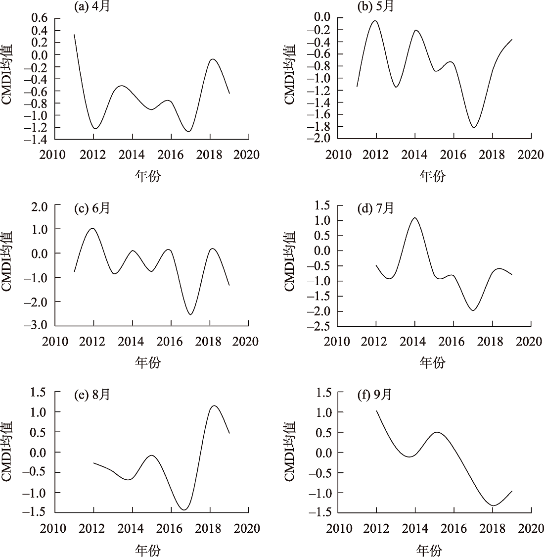
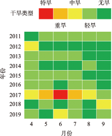
图8
不同年月干旱程度"

| [1] | 张世喆, 朱秀芳, 刘婷婷, 等. 基于多维Copula的中国干旱特征及危险性分析[J]. 干旱区地理, 2022, 45(2): 333-345. |
| [Zhang Shizhe, Zhu Xiufang, Liu Tingting, et al. Drought characteristics and risk hazard in China based on multidimensional Copula model[J]. Arid Land Geography, 2022, 45(2): 333-345.] | |
| [2] | 范磊, 吕爱锋, 张文翔. 青海省干旱时空特征及与大气环流响应关系[J]. 干旱区资源与环境, 2021, 35(12): 60-65. |
| [Fan Lei, Lü Aifeng, Zhang Wenxiang. Temporal-spatial variation characteristics of drought and its relationship with atmospheric circulation in Qinghai Province[J]. Journal of Arid Land Resources and Environment, 2021, 35(12): 60-65.] | |
| [3] | IPCC. Climate Change 2021: The physical science basis: Contribution of working group I to the sixth assessment report of the intergovernmental panel on climate change[M]. Cambridge: Cambridge University Press, 2021. |
| [4] | Thilagaraj P, Masilamani P, Venkatesh R, et al. Google earth engine based agricultural drought monitoring in Kodavanar Watershed, part of Amaravathi Basin, Tamil Nadu, India[J]. International Archives of the Photogrammetry, Remote Sensing and Spatial Information Sciences, 2021, XLIII-B5-2021: 43-49. |
| [5] | 孙灏, 陈云浩, 孙洪泉. 典型农业干旱遥感监测指数的比较及分类体系[J]. 农业工程学报, 2012, 28(14): 147-154. |
| [Sun Hao, Chen Yunhao, Sun Hongquan. Comparisons and classification system of typical remote sensing indexes for agricultural drought[J]. Transactions of the Chinese Society of Agricultural Engineering, 2012, 28(14): 147-154.] | |
| [6] |
吴泽棉, 邱建秀, 刘苏峡, 等. 基于土壤水分的农业干旱监测研究进展[J]. 地理科学进展, 2020, 39(10): 1758-1769.
doi: 10.18306/dlkxjz.2020.10.014 |
|
[Wu Zemian, Qiu Jianxiu, Liu Suxia, et al. Advances in agricultural drought monitoring based on soil moisture[J]. Progress in Geography, 2020, 39(10): 1758-1769.]
doi: 10.18306/dlkxjz.2020.10.014 |
|
| [7] |
Dai A. Increasing drought under global warming in observations and models[J]. Nature Climate Change, 2013, 3(1): 52-58.
doi: 10.1038/nclimate1633 |
| [8] |
刘宪锋, 朱秀芳, 潘耀忠, 等. 农业干旱监测研究进展与展望[J]. 地理学报, 2015, 70(11): 1835-1848.
doi: 10.11821/dlxb201511012 |
|
[Liu Xianfeng, Zhu Xiufang, Pan Yaozhong, et al. Agricultural drought monitor: Progress, challenges and prospect[J]. Acta Geographica Sinica, 2015, 70(11): 1835-1848.]
doi: 10.11821/dlxb201511012 |
|
| [9] |
Lee S J, Kim N R, Lee Y W. Development of integrated crop drought index by combining rainfall, land surface temperature, evapotranspiration, soil moisture, and vegetation index for agricultural drought monitoring[J]. Remote Sensing, 2021, 13(9): 1778, doi: 10.3390/rs13091778.
doi: 10.3390/rs13091778 |
| [10] | 胡鹏飞, 李净, 王丹, 等. 基于MODIS和TRMM数据的黄土高原农业干旱监测[J]. 干旱区地理, 2019, 42(1): 173-178. |
| [Hu Pengfei, Li Jing, Wang Dan, et al. Monitoring agricultural drought in the Loess Plateau using MODIS and TRMM data[J]. Arid Land Geography, 2019, 42(1): 173-178.] | |
| [11] | 温庆志, 孙鹏, 张强, 等. 基于多源遥感数据的农业干旱监测模型构建及应用[J]. 生态学报, 2019, 39(20): 7757-7770. |
| [Wen Qingzhi, Sun Peng, Zhang Qiang, et al. An integrated agricultural drought monitoring model based on multi-source remote sensing data: Model development and application[J]. Acta Ecologica Sinica, 2019, 39(20): 7757-7770.] | |
| [12] |
刘高鸣, 谢传节, 何天乐. 基于多源数据的农业干旱监测模型构建[J]. 地球信息科学学报, 2019, 21(11): 1811-1822.
doi: 10.12082/dqxxkx.2019.180666 |
|
[Liu Gaoming, Xie Chuanjie, He Tianle. Agricultural drought monitoring model constructing based on multi-source data[J]. Journal of Geo-information Science, 2019, 21(11): 1811-1822.]
doi: 10.12082/dqxxkx.2019.180666 |
|
| [13] | Brown J F, Wardlow B D, Tadesse T, et al. The vegetation drought response index (VegDRI): A new integrated approach for monitoring drought stress in vegetation[J]. GIScience & Remote Sensing, 2008, 45(1): 16-46. |
| [14] |
Wu J, Zhou L, Liu M, et al. Establishing and assessing the integrated surface drought index (ISDI) for agricultural drought monitoring in mid-eastern China[J]. International Journal of Applied Earth Observation and Geoinformation, 2013, 23: 397-410.
doi: 10.1016/j.jag.2012.11.003 |
| [15] | 邵京, 李晓松, 杨珺婷, 等. 光学与雷达遥感协同的大尺度草地灌丛化监测研究[J]. 干旱区资源与环境, 2021, 35(2): 130-135. |
| [Shao Jing, Li Xiaosong, Yang Junting, et al. Study on large scale grassland shrub monitoring based on optical and radar remote sensing[J]. Journal of Arid Land Resources and Environment, 2021, 35(2): 130-135.] | |
| [16] | 刘斌, 郭星, 朱宇恩. 基于随机森林模型的土壤重金属源解析——以晋中盆地为例[J]. 干旱区资源与环境, 2019, 33(1): 106-111. |
| [Liu Bin, Guo Xing, Zhu Yu’en. Analysis of soil heavy metal sources in Jinzhong Basin based on random forest model[J]. Journal of Arid Land Resources and Environment, 2019, 33(1): 106-111.] | |
| [17] |
高亮, 杜鑫, 李强子, 等. 融合土地覆盖和土壤水分产品的近地表空气温度空间化方法[J]. 地球信息科学学报, 2020, 22(10): 2023-2037.
doi: 10.12082/dqxxkx.2020.200078 |
|
[Gao Liang, Du Xin, Li Qiangzi, et al. A near-surface air temperature spatialization method integrating landuse and soil moisture products[J]. Journal of Geo-information Science, 2020, 22(10): 2023-2037.]
doi: 10.12082/dqxxkx.2020.200078 |
|
| [18] | 沈润平, 郭佳, 张婧娴. 基于随机森林的遥感干旱监测模型的构建[J]. 地球信息科学学报, 2016, 19(1): 125-133. |
| [Shen Runping, Guo Jia, Zhang Jingxian. Construction of a drought monitoring model using the random forest based remote sensing[J]. Journal of Geo-information Science, 2016, 19(1): 125-133.] | |
| [19] | 董婷, 任东, 邵攀, 等. 基于多源遥感数据和随机森林的综合旱情指标构建[J]. 农业机械学报, 2019, 50(8): 200-212. |
| [Dong Ting, Ren Dong, Shao Pan, et al. Construction of integrated drought condition index based on multi-sensor remote sensing and random forest[J]. Transactions of the Chinese Society for Agricultural Machinery, 2019, 50(8): 200-212.] | |
| [20] | 庞素菲, 魏伟, 郭泽呈, 等. 基于TVDI的甘肃省农业旱情特征及其影响因素[J]. 生态学杂志, 2019, 38(6): 1849-1860. |
| [Pang Sufei, Guo Zecheng, et al. Agricultural drought characteristics and its influencing factors in Gansu Province based on TVDI[J]. Chinese Journal of Ecology, 2019, 38(6): 1849-1860.] | |
| [21] | 胡蝶, 沙莎, 王丽娟, 等. 欧空局主被动微波土壤水分融合产品在甘肃省干旱监测中的应用[J]. 干旱气象, 2019, 37(4): 517-528. |
| [Hu Die, Wang Lijuan, et al. Drought monitoring applications of the European space agency climate change initiative soil moisture combined product in Gansu Province[J]. Journal of Arid Meteorology, 2019, 37(4): 517-528.] | |
| [22] | 魏堃, 张勃, 马尚谦, 等. 甘肃省河东地区春玉米干旱演变特征及灾损风险区划[J]. 干旱地区农业研究, 2019, 37(6): 238-247. |
| [Wei Kun, Zhang Bo, Ma Shangqian, et al. Drought evolution characteristics and risk zoning of spring maize in Hedong of Gansu Province[J]. Agricultural Research in the Arid Areas, 2019, 37(6): 238-247.] | |
| [23] | 李栋梁, 刘德祥. 甘肃气候[M]. 北京: 气象出版社, 2000: 2-105. |
| [Li Dongliang, Liu Dexiang. Gansu climate[M]. Beijing: Meteorological Publishing House, 2000: 2-105.] | |
| [24] |
郭斌, 邢文雪, 李云, 等. 基于TRMM 3B43产品的1998—2016年黄淮海平原降水时空特征研究[J]. 地理科学, 2021, 41(7): 1285-1294.
doi: 10.13249/j.cnki.sgs.2021.07.019 |
|
[Guo Bin, Xing Wenxue, Li Yun, et al. Temporal and spatial characteristics of precipitation based on TRMM 3B43 product in the Huang-Huai-Hai Plain during 1998—2016[J]. Scientia Geographica Sinica, 2021, 41(7): 1285-1294.]
doi: 10.13249/j.cnki.sgs.2021.07.019 |
|
| [25] |
彭振华, 李艳忠, 余文君, 等. 遥感降水产品在中国不同气候区的适用性研究[J]. 地球信息科学学报, 2021, 23(7): 1296-1311.
doi: 10.12082/dqxxkx.2021.200348 |
|
[Peng Zhenhua, Li Yanzhong, Yu Wenjun, et al. Research on the applicability of remote sensing precipitation products in different climatic regions of China[J]. Journal of Geo-information Science, 2021, 23(7): 1296-1311.]
doi: 10.12082/dqxxkx.2021.200348 |
|
| [26] |
费龙, 邓国荣, 张洪岩, 等. 基于降水Z指数的朝鲜降水及旱涝时空特征[J]. 自然资源学报, 2020, 35(12): 3051-3063.
doi: 10.31497/zrzyxb.20201219 |
|
[Fei Long, Deng Guorong, Zhang Hongyan, et al. Spatiotemporal patterns of precipitation and drought and flood using Z-index in Democratic People’s Republic of Korea[J]. Journal of Natural Resources, 2020, 35(12): 3051-3063.]
doi: 10.31497/zrzyxb.20201219 |
|
| [27] |
余灏哲, 李丽娟, 李九一. 基于TRMM降尺度和MODIS数据的综合干旱监测模型构建[J]. 自然资源学报, 2020, 35(10): 2553-2568.
doi: 10.31497/zrzyxb.20201019 |
|
[Yu Haozhe, Li Lijuan, Li Jiuyi. Establishment of comprehensive drought monitoring model based on downscaling TRMM and MODIS data[J]. Journal of Natural Resources, 2020, 35(10): 2553-2568.]
doi: 10.31497/zrzyxb.20201019 |
|
| [28] |
李净, 张晓. TRMM降水数据的空间降尺度方法研究[J]. 地理科学, 2015, 35(9): 1164-1169.
doi: 10.13249/j.cnki.sgs.2015.09.1164 |
|
[Li Jing, Zhang Xiao. Downscaling method of TRMM satellite precipitation data[J]. Scientia Geographica Sinica, 2015, 35(9): 1164-1169.]
doi: 10.13249/j.cnki.sgs.2015.09.1164 |
|
| [29] | Yu G, Di L. Downscaling of global soil moisture using auxiliary data[C]// Yang W. International Geoscience & Remote Sensing Symposium. Institute of Electrical and Electronics Engineers, 2008: 230-233. |
| [30] | 杜灵通, 田庆久, 王磊, 等. 基于多源遥感数据的综合干旱监测模型构建[J]. 农业工程学报, 2014, 30(9): 126-132. |
| [Du Lingtong, Tian Qingjiu, Wang Lei, et al. A synthesized drought monitoring model based on multi-source remote sensing data[J]. Transactions of the Chinese Society of Agricultural Engineering, 2014, 30(9): 126-132.] | |
| [31] | 张静, 魏伟, 庞素菲, 等. 基于FY-3C和TRMM数据的西北干旱区干旱监测与评估[J]. 生态学杂志, 2020, 39(2): 690-702. |
| [Zhang Jing, Pang Sufei, et al. Monitoring and assessment of drought in arid area in northwest China based on FY-3C and TRMM Data[J]. Chinese Journal of Ecology, 2020, 39(2): 690-702.] | |
| [32] | 谢五三, 田红, 王胜. 基于CI指数的淮河流域干旱时空特征研究[J]. 气象, 2013, 39(9): 1171-1175. |
| [Xie Wusan, Tian Hong, Wang Sheng. Study on temporal-spatial characteristics of drought in Huaihe River Basin based on CI index[J]. Meteorological Monthly, 2013, 39(9): 1171-1175.] | |
| [33] | GBT 20481. 2006气象干旱等级[S]. 2006: 40-41. |
| [GBT 20481. Meteorological drought grade in 2006[S]. 2006: 40-41.] | |
| [34] |
张调风, 张勃, 王有恒, 等. 基于综合气象干旱指数的石羊河流域近50年气象干旱特征分析[J]. 生态学报, 2013, 33(3): 975-984.
doi: 10.5846/stxb201203030285 |
|
[Zhang Tiaofeng, Zhang Bo, Wang Youheng, et al. Drought characteristics in the Shiyang River Basin during the recent 50 years based on a composite index[J]. Acta Ecologica Sinica, 2013, 33(3): 975-984.]
doi: 10.5846/stxb201203030285 |
|
| [35] |
Vicente-Serrano S M, Beguería S, López-Moreno J I. A multiscalar drought index sensitive to global warming: The standardized precipitation evapotranspiration index-SPEI[J]. Journal of Climate, 2010, 23(7): 1696-1718.
doi: 10.1175/2009JCLI2909.1 |
| [36] | 芳馨蕊, 温兆飞, 陈吉龙, 等. 基于随机森林回归模型的悬浮泥沙浓度遥感估算[J]. 遥感学报, 2019, 23(4): 756-772. |
| [Fang Xinrui, Wen Zhaofei, Chen Jilong, et al. Remote sensing estimation of suspended sediment concentration based on random forest regression model[J]. National Remote Sensing Bulletin, 2019, 23(4): 756-772.] | |
| [37] | 任丽, 杨联安, 王辉, 等. 基于随机森林的苹果区土壤有机质空间预测[J]. 干旱区资源与环境, 2018, 32(8): 141-146. |
| [Ren Li, Yang Lian’an, Wang Hui, et al. Spatial prediction of soil organic matter in apple region based on random forest[J]. Journal of Arid Land Resources and Environment, 2018, 32(8): 141-146.] | |
| [38] | 洪文泉. 甘肃发布2017年十大天气气候事件[N]. 甘肃日报, 2018-01-04( 008). |
| [Hong Wenquan. Gansu released the top 10 weather and climate events of 2017[N]. Gansu Daily, 2018-01-04( 008).] | |
| [39] | 韩兰英, 张强, 赵红岩, 等. 甘肃省农业干旱灾害损失特征及其对气候变暖的响应[J]. 中国沙漠, 2016, 36(3): 767-776. |
| [Han Lanying, Zhang Qiang, Zhao Hongyan, et al. The characteristics agricultural drought disaster loss and response to climate warming in Gansu, China[J]. Journal of Desert Research, 2016, 36(3): 767-776.] | |
| [40] | 赖力, 粟晓玲, 冯凯. 甘肃省农业干旱对多尺度气象干旱的响应[J]. 节水灌溉, 2020(2): 102-108. |
| [Lai Li, Su Xiaoling, Feng Kai. Response of agricultural drought to multi-scale meteorological drought in Gansu Province[J]. Water Saving Irrigation, 2020(2): 102-108.] |
| [1] | 龚栋栋, 高凡, 吴彬, 刘坤. 基于GRACE的新疆平原区地下水干旱时空变化及其对气象干旱的响应[J]. 干旱区地理, 2024, 47(9): 1496-1507. |
| [2] | 刘雨, 梅华, 范文波, 任聪哲, 王世威, 李顺顺. 基于SPEI的1992—2022年塔额盆地干旱时空变化特征[J]. 干旱区地理, 2024, 47(8): 1338-1347. |
| [3] | 吴梦雨, 李冬杰, 韩玉国, 邱业, 曲芝旭. 河西走廊农田灌溉面积阈值分析[J]. 干旱区地理, 2024, 47(7): 1165-1174. |
| [4] | 谢俊博, 王兴鹏, 何帅, 刘洋, 忠智博, 李妍, 洪国军. 基于光谱指数建模的沙井子灌区土壤盐分反演[J]. 干旱区地理, 2024, 47(7): 1199-1209. |
| [5] | 朱瑷嫒, 殷颂葵, 刘琼慧. 中国西北地区农业生态效率时空分异及影响因素研究[J]. 干旱区地理, 2024, 47(7): 1210-1219. |
| [6] | 褚家琦, 蒋志辉. 新疆农业水资源绿色效率时空演变及影响因素研究[J]. 干旱区地理, 2024, 47(7): 1231-1241. |
| [7] | 赵国兵, 郑江华, 王蕾, 高健, 罗磊, 尼格拉·吐尔逊, 韩万强, 关靖云. 基于RF分类调优和SNIC聚类的新疆红枣种植区遥感提取[J]. 干旱区地理, 2024, 47(6): 1004-1014. |
| [8] | 夏文浩, 霍瑜, 逯渊, 王超毅. 新疆农业碳排放的时空差异与空间溢出效应分析[J]. 干旱区地理, 2024, 47(6): 1084-1096. |
| [9] | 吕娜, 郭梦京, 赵馨, 刘可乐, 黄宇佳. 内陆淡水湖博斯腾湖水质遥感反演及时空演变特征[J]. 干旱区地理, 2024, 47(6): 953-966. |
| [10] | 王岱, 崔洋, 王素艳, 张雯. 1961—2020年宁夏干旱事件年代际变化及风险评估[J]. 干旱区地理, 2024, 47(5): 785-797. |
| [11] | 向燕芸, 王弋, 陈亚宁, 张齐飞, 张玉杰. 基于CMIP6模式的叶尔羌河流域未来水文干旱风险预估[J]. 干旱区地理, 2024, 47(5): 798-809. |
| [12] | 黄曼捷, 李艳忠, 王渊刚, 于志国, 庄稼成, 星寅聪. 多源遥感降水产品在西北干旱区的气象干旱性能评估[J]. 干旱区地理, 2024, 47(4): 549-560. |
| [13] | 张菩, 陈留勤, 邵崇建, 李文, 杜丁丁. 新疆阿克苏温宿大峡谷丹霞地貌特征及成因分析[J]. 干旱区地理, 2024, 47(4): 576-587. |
| [14] | 刘瑞亮, 贾科利, 李小雨, 陈睿华, 王怡婧, 张俊华. 组合光学和微波遥感的耕地土壤含盐量反演[J]. 干旱区地理, 2024, 47(3): 433-444. |
| [15] | 王剑, 管瑶, 贺兴宏, 代云豪, 陈艺伟, 王育强, 李会文, 范德宝. 2000—2021年图木舒克市生态环境质量动态监测与评价[J]. 干旱区地理, 2024, 47(3): 465-473. |
|
||