- 2025年5月12日 星期一
干旱区地理 ›› 2021, Vol. 44 ›› Issue (4): 1070-1082.doi: 10.12118/j.issn.1000–6060.2021.04.19
周玄德1( ),郭华东2,杨胜天3,孜比布拉·司马义3(),邓祖涛1,梁滨1
收稿日期:2020-04-24
修回日期:2021-02-23
出版日期:2021-07-25
发布日期:2021-08-02
通讯作者:
孜比布拉·司马义
作者简介:周玄德(1985-),男,博士,讲师,主要从事资源利用与城乡规划研究. E-mail: 基金资助:
ZHOU Xuande1(),GUO Huadong2,YANG Shengtian3,Zibibula SIMAYI3(),DENG Zutao1,LIANG Bin1
Received:2020-04-24
Revised:2021-02-23
Online:2021-07-25
Published:2021-08-02
Contact:
SIMAYI Zibibula
摘要:
干旱区绿洲城市生态环境极为脆弱,准确了解生态环境时空变动情况具有重要意义。选择典型的干旱绿洲城市克拉玛依市为研究对象,分别选取2001、2006、2011年和2016年4个时期的遥感影像,通过计算遥感生态指数表征生态环境质量状况,从变化趋势、空间分布、等级划分、变动特征及重心转移等方面进行分析。结果表明:(1) 研究区遥感生态指数呈现波动性变化,整体水平不高,均维持在0.35上下波动,其中主要以低、较低等级的生态指数为主。(2) 研究区生态指数等级变化主要表现为一个等级的变化,越级变化的较少,不同等级遥感生态指数区域面积在不同时间段的变化量、动态度差异显著。(3) 低生态指数到高遥感生态指数的生态位表现为明显的上升趋势,生态位数值均较小,最大值仅0.3677,不同等级生态指数生态位的提升还有很大空间。(4) 不同等级遥感生态指数的重心都出现了不同程度的偏移,其中高生态指数区域的空间移动性大,平均距离为42.60 km,低生态指数区域在空间上相对稳定。该研究探寻了人类活动过程中生态环境的时空变动规律,对干旱区绿洲城市的可持续发展具有一定的现实意义。
周玄德,郭华东,杨胜天,孜比布拉·司马义,邓祖涛,梁滨. 干旱区绿洲城市生态环境时空变化特征分析——以克拉玛依市为例[J]. 干旱区地理, 2021, 44(4): 1070-1082.
ZHOU Xuande,GUO Huadong,YANG Shengtian,Zibibula SIMAYI,DENG Zutao,LIANG Bin. Temporal and spatial variation characteristics of oasis urban ecological environment in arid region: A case study of Karamay City[J]. Arid Land Geography, 2021, 44(4): 1070-1082.
表1
各主成分特征值"
| 主成分 | 2001年 | 2006年 | 2011年 | 2016年 | ||||
|---|---|---|---|---|---|---|---|---|
| 特征值 | 贡献率/% | 特征值 | 贡献率/% | 特征值 | 贡献率/% | 特征值 | 贡献率/% | |
| PC1 | 0.0992 | 85.6377 | 0.1047 | 85.7392 | 0.0505 | 85.5012 | 0.0894 | 89.4827 |
| PC2 | 0.0112 | 9.6721 | 0.0139 | 11.3759 | 0.0048 | 8.1922 | 0.0069 | 6.8943 |
| PC3 | 0.0040 | 3.4805 | 0.0026 | 2.1644 | 0.0027 | 4.5911 | 0.0034 | 3.4283 |
| PC4 | 0.0014 | 1.2097 | 0.0009 | 0.7206 | 0.0010 | 1.7155 | 0.0002 | 0.1947 |
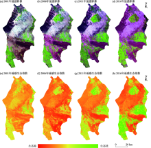
图1
克拉玛依区遥感影像(RGB:543)和遥感生态指数空间分布"

表2
生态指数及相关指标基本统计值"
| 指标 | 2001年 | 2006年 | ||||||
|---|---|---|---|---|---|---|---|---|
| 最小值 | 最大值 | 均值 | 标准差 | 最小值 | 最大值 | 均值 | 标准差 | |
| NDVI | -1.0000 | 0.7604 | 0.1280 | 0.1318 | -1.0000 | 0.7795 | 0.1449 | 0.1582 |
| WET | -0.5470 | 0.0665 | -0.2016 | 0.0614 | -0.5733 | 0.0714 | -0.1785 | 0.0596 |
| LST | 29.3201 | 57.8943 | 47.2234 | 3.3495 | 12.0327 | 38.5387 | 32.3419 | 3.0871 |
| NDBSI | -0.6327 | 1.0000 | 0.1971 | 0.0890 | -0.5184 | 1.0000 | 0.1927 | 0.1156 |
| RSEI | 0.0000 | 1.0000 | 0.3523 | 0.1234 | 0.0000 | 1.0000 | 0.3446 | 0.1256 |
| 指标 | 2011年 | 2016年 | ||||||
| 最小值 | 最大值 | 均值 | 标准差 | 最小值 | 最大值 | 均值 | 标准差 | |
| NDVI | -0.5216 | 1.0000 | 0.1945 | 0.1968 | -0.7725 | 0.8619 | 0.2935 | 0.2601 |
| WET | -0.7883 | 0.1483 | -0.1664 | 0.0692 | -1.3451 | 0.2144 | -0.0472 | 0.0764 |
| LST | 19.9292 | 47.4173 | 36.2315 | 4.5555 | 15.7962 | 46.5827 | 35.8338 | 6.3602 |
| NDBSI | -0.7142 | 1.0000 | 0.1600 | 0.1417 | -0.6426 | 0.5799 | 0.0730 | 0.2099 |
| RSEI | 0.0000 | 1.0000 | 0.3592 | 0.2026 | 0.0000 | 1.0000 | 0.3184 | 0.2579 |

图2
遥感生态指数等级空间分布 注:A、B、C、D、E依次为低、较低、中等、较高、高生态指数区。下同。"
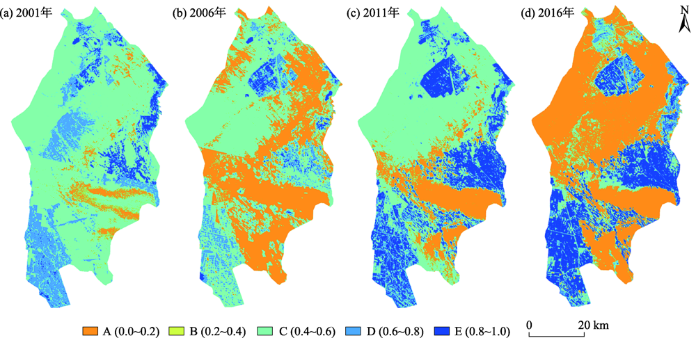
表3
不同遥感生态指数等级面积百分比"
| RSEI等级 | 2001年 | 2006年 | 2011年 | 2016年 | ||||
|---|---|---|---|---|---|---|---|---|
| 面积/km2 | 占比/% | 面积/km2 | 占比/% | 面积/km2 | 占比/% | 面积/km2 | 占比/% | |
| A | 223.70 | 5.81 | 1547.53 | 40.17 | 656.16 | 17.03 | 2107.60 | 54.71 |
| B | 2637.34 | 68.46 | 1831.28 | 47.54 | 2035.42 | 52.84 | 592.43 | 15.38 |
| C | 830.42 | 21.56 | 401.18 | 10.41 | 485.61 | 12.61 | 382.55 | 9.93 |
| D | 127.42 | 3.31 | 70.19 | 1.82 | 519.34 | 13.48 | 416.90 | 10.82 |
| E | 33.36 | 0.87 | 2.03 | 0.05 | 155.70 | 4.04 | 352.75 | 9.16 |

图3
遥感生态指数等级变化"

表4
遥感生态指数等级变化统计"
| 等级 | 2001—2006年 | 2006—2011年 | 2011—2016年 | 2001—2016年 | ||||
|---|---|---|---|---|---|---|---|---|
| 面积/km2 | 占比/% | 面积/km2 | 占比/% | 面积/km2 | 占比/% | 面积/km2 | 占比/% | |
| -4 | 0.32 | 0.01 | - | - | 0.54 | 0.01 | 0.49 | 0.01 |
| -3 | 6.01 | 0.16 | 0.35 | 0.01 | 13.11 | 0.34 | 3.59 | 0.09 |
| -2 | 85.68 | 2.22 | 5.29 | 0.14 | 82.31 | 2.14 | 212.22 | 5.51 |
| -1 | 1947.11 | 50.55 | 57.60 | 1.50 | 1794.00 | 46.57 | 1920.38 | 49.85 |
| 0 | 1662.55 | 43.16 | 1930.25 | 50.11 | 1312.67 | 34.08 | 797.16 | 20.69 |
| 1 | 126.27 | 3.28 | 1403.79 | 36.44 | 494.87 | 12.85 | 399.94 | 10.38 |
| 2 | 22.81 | 0.59 | 376.10 | 9.76 | 126.26 | 3.28 | 396.98 | 10.31 |
| 3 | 1.46 | 0.04 | 72.90 | 1.89 | 28.09 | 0.73 | 121.34 | 3.15 |
| 4 | 0.01 | 0.00 | 5.96 | 0.15 | 0.37 | 0.01 | 0.12 | 0.00 |
表5
不同等级遥感生态指数变化量及动态度"
| RSEI等级 | 2001—2006年 | 2006—2011年 | 2011—2016年 | |||
|---|---|---|---|---|---|---|
| 增加量/km2 | 动态度/% | 增加量/km2 | 动态度/% | 增加量/km2 | 动态度/% | |
| A | 1323.83 | 118.36 | -891.37 | -11.52 | 1451.44 | 44.24 |
| B | -806.06 | -6.11 | 204.14 | 2.23 | -1442.99 | -14.18 |
| C | -429.23 | -10.34 | 84.43 | 4.21 | -103.06 | -4.24 |
| D | -57.22 | -8.98 | 449.15 | 127.97 | -102.44 | -3.95 |
| E | -31.32 | -18.78 | 153.66 | 1510.76 | 197.06 | 25.31 |
表6
不同等级遥感生态指数均值及生态位"
| RSEI等级 | 2001年 RSEI均值 | 2001—2006年 | 2006年 RSEI均值 | 2006—2011年 | 2011年 RSEI均值 | 2011—2016年 | 2016年 RSEI均值 | |||
|---|---|---|---|---|---|---|---|---|---|---|
| 势 | 生态位 | 势 | 生态位 | 势 | 生态位 | |||||
| A | 0.1778 | -0.0399 | 0.0546 | 0.1379 | 0.0103 | 0.0606 | 0.1482 | -0.0167 | 0.0521 | 0.1315 |
| B | 0.3045 | -0.0349 | 0.1104 | 0.2696 | 0.0016 | 0.1094 | 0.2712 | 0.0062 | 0.1132 | 0.2774 |
| C | 0.4789 | -0.0121 | 0.1952 | 0.4668 | 0.0362 | 0.2056 | 0.5030 | -0.0021 | 0.2033 | 0.5009 |
| D | 0.6914 | -0.0367 | 0.2721 | 0.6547 | 0.0317 | 0.2791 | 0.6864 | 0.0255 | 0.2913 | 0.7119 |
| E | 0.8519 | 0.0190 | 0.3677 | 0.8709 | -0.0116 | 0.3453 | 0.8594 | -0.0186 | 0.3401 | 0.8408 |
表7
不同遥感生态指数重心经纬度坐标"
| RSEI 等级 | 2001年 | 2006年 | 2011年 | 2016年 | ||||
|---|---|---|---|---|---|---|---|---|
| 经度/E | 纬度/N | 经度/E | 纬度/N | 经度/E | 纬度/N | 经度/E | 纬度/N | |
| A | 85°00′13.51880″ | 45°06′38.45573″ | 84°57′37.04680″ | 45°09′44.24302″ | 84°57′05.06798″ | 45°03′44.26575″ | 84°54′30.91428″ | 45°14′59.11490″ |
| B | 84°54′50.28787″ | 45°13′28.15689″ | 84°52′15.42253″ | 45°13′33.02934″ | 84°53′27.15518″ | 45°16′44.03351″ | 84°54′02.83357″ | 45°10′47.48842″ |
| C | 84°51′25.98427″ | 45°06′06.34960″ | 84°54′52.09637″ | 45°08′19.29840″ | 84°53′53.87569″ | 45°05′18.73948″ | 84°57′39.73842″ | 45°11′42.68208″ |
| D | 85°03′51.65940″ | 45°16′40.94337″ | 84°58′57.01781″ | 45°22′49.77506″ | 84°55′47.51930″ | 45°05′30.36632″ | 84°55′18.64866″ | 45°05′43.32496″ |
| E | 85°05′19.97127″ | 45°18′41.47623″ | 84°44′34.73225″ | 44°57′30.56622″ | 85°02′13.76825″ | 45°18′08.03169″ | 84°54′02.74515″ | 44°59′54.89837″ |
表8
不同等级遥感生态指数重心偏移距离与方位角"
| RSEI 等级 | 2001—2006年 | 2006—2011年 | 2011—2016年 | |||
|---|---|---|---|---|---|---|
| 偏移距离/km | 方位角/(°) | 偏移距离/km | 方位角/(°) | 偏移距离/km | 方位角/(°) | |
| A | 6.55 | 328.65 | 11.18 | 183.62 | 20.79 | 350.84 |
| B | 3.36 | 270.95 | 6.05 | 14.91 | 11.04 | 175.96 |
| C | 6.08 | 47.74 | 5.72 | 192.84 | 12.83 | 22.54 |
| D | 13.07 | 330.72 | 32.36 | 187.33 | 0.74 | 302.14 |
| E | 47.70 | 214.80 | 44.62 | 31.06 | 35.47 | 197.55 |

图4
不同等级遥感生态指数重心转移 注:●表示各年份不同区域的重心位置。"

| [1] | 周亮, 车磊, 孙东琪. 中国城镇化与经济增长的耦合协调发展及影响因素[J]. 经济地理, 2019, 39(6):97-107. |
| [ Zhou Liang, Che Lei, Sun Dongqi. The coupling coordination development between urbanization and economic growth and its influencing factors in China[J]. Economic Geography, 2019, 39(6):97-107. ] | |
| [2] |
崔学刚, 方创琳, 李君, 等. 城镇化与生态环境耦合动态模拟模型研究进展[J]. 地理科学进展, 2019, 38(1):111-125.
doi: 10.18306/dlkxjz.2019.01.010 |
|
[ Cui Xuegang, Fang Chuangling, Li Jun, et al. Progress in dynamic simulation modeling of urbanization and ecological environment coupling[J]. Progress in Geography, 2019, 38(1):111-125. ]
doi: 10.18306/dlkxjz.2019.01.010 |
|
| [3] |
张洪, 李中元, 李彦. 基于生态安全的山地城镇土地可持续利用模式研究——以云南大理市为例[J]. 地理研究, 2019, 38(11):2681-2694.
doi: 10.11821/dlyj020181341 |
|
[ Zhang Hong, Li Zhongyuan, Li Yan. Study on sustainable land use model in mountain towns based on ecological security: Taking Dali City of Yunnan Province as an example[J]. Geographical Research, 2019, 38(11):2681-2694. ]
doi: 10.11821/dlyj020181341 |
|
| [4] | 蒋慧峰. 城镇化与生态环境耦合协调发展研究[J]. 经济研究导刊, 2019(4):157-161. |
| [ Jiang Huifeng. Study on coupling and coordinated development between urbanization and eco-environment[J]. Economic Research Guide, 2019(4):157-161. ] | |
| [5] | 乔标, 方创琳. 城市化与生态环境协调发展的动态耦合模型及其在干旱区的应用[J]. 生态学报, 2005, 25(11):211-217. |
| [ Qiao Biao, Fang Chuangling. The dynamic coupling model of the harmonious development between urbanization and eco-environment and its application in arid area[J]. Acta Ecologica Sinica, 2005, 25(11):211-217. ] | |
| [6] |
陈晓红, 万鲁河. 城市化与生态环境耦合的脆弱性与协调性作用机制研究[J]. 地理科学, 2013, 33(12):1450-1457.
doi: 10.13249/j.cnki.sgs.2013.012.1450 |
|
[ Chen Xiaohong, Wan Luhe. The interactive mechanisms for the coordination and vulnerability between regional urban and eco-environment[J]. Scientia Geographica Sinica, 2013, 33(12):1450-1457. ]
doi: 10.13249/j.cnki.sgs.2013.012.1450 |
|
| [7] | 王少剑, 方创琳, 王洋. 京津冀地区城市化与生态环境交互耦合关系定量测度[J]. 生态学报, 2015, 35(7):2244-2254. |
| [ Wang Shaojian, Fang Chuangling, Wang Yang. Quantitative investigation of the interactive coupling relationship between urbanization and eco-environment[J]. Acta Ecologica Sinica, 2015, 35(7):2244-2254. ] | |
| [8] | 孙东琪, 张京祥, 朱传耿, 等. 中国生态环境质量变化态势及其空间分异分析[J]. 地理学报, 2012, 67(12):1599-1610. |
| [ Sun Dongqi, Zhang Jingxiang, Zhu Chuangeng, et al. An assessment of China’s ecological environment quality change and its spatial variation[J]. Acta Geographica Sinica, 2012, 67(12):1599-1610. ] | |
| [9] | 刘远书, 高文文, 侯坤, 等. 南水北调中线水源区生态环境变化分析研究[J]. 长江流域资源与环境, 2015, 24(3):440-446. |
| [ Liu Yuanshu, Gao Wenwen, Hou Kun, et al. Analysis of ecological environment change on watershed of the middle route of south-north water diversion project[J]. Resources and Environment in the Yangtze Basin, 2015, 24(3):440-446. ] | |
| [10] | 张春桂, 李计英. 基于3S技术的区域生态环境质量监测研究[J]. 自然资源学报, 2010, 25(12):2060-2071. |
| [ Zhang Chungui, Li Jiying. Study of regional eco-environmental quality monitoring based on 3S techniques[J]. Journal of Natural Resources, 2010, 25(12):2060-2071. ] | |
| [11] | 徐涵秋. 城市遥感生态指数的创建及其应用[J]. 生态学报, 2013, 33(24):7853-7862. |
| [ Xu Hanqiu. A remote sensing urban ecological index and its application[J]. Acta Ecologica Sinica, 2013, 33(24):7853-7862. ] | |
| [12] | 吴志杰, 王猛猛, 陈绍杰, 等. 基于遥感生态指数的永定矿区生态变化监测与评价[J]. 生态科学, 2016, 35(5):200-207. |
| [ Wu Zhijie, Wang Mengmeng, Chen Shaojie, et al. Monitoring and evaluation of ecological environment’s spatio-temporal variation in mine based on RSEI in Yongding mine[J]. Ecological Science, 2016, 35(5):200-207. ] | |
| [13] | 宋慧敏, 薛亮. 基于遥感生态指数模型的渭南市生态环境质量动态监测与分析[J]. 应用生态学报, 2016, 27(12):3913-3919. |
| [ Song Huimin, Xue Liang. Dynamic monitoring and analysis of ecological environment in Weinan City, northwest China based on RSEI model[J]. Chinese Journal of Applied Ecology, 2016, 27(12):3913-3919. ] | |
| [14] | 闫正龙, 高凡, 何兵. 3S技术在我国生态环境动态演变研究中的应用进展[J]. 地理信息世界, 2019, 26(2):43-48. |
| [ Yan Zhenglong, Gao Fan, He Bing. Review on the application of 3S technologies in the dynamic evolution of ecological environment at China[J]. Geomatics World, 2019, 26(2):43-48. ] | |
| [15] | 单薇, 金晓斌, 孟宪素, 等. 基于多源遥感数据的土地整治生态环境质量动态监测[J]. 农业工程学报, 2019, 35(1):234-242. |
| [ Shan Wei, Jin Xiaobin, Meng Xiansu, et al. Dynamical monitoring of ecological environment quality of land consolidation based on multi-source remote sensing data[J]. Transactions of the Chinese Society of Agricultural Engineering, 2019, 35(1):234-242. ] | |
| [16] | 顾成林, 周健. 大连市生态环境质量研究[J]. 黑龙江环境通报, 2012, 36(3):37-40. |
| [ Gu Chenglin, Zhou Jian. Research on ecological environment quality of Dalian City[J]. Heilongjiang Environmental Journal, 2012, 36(3):37-40. ] | |
| [17] | 周玄德, 窦文章, 李国栋. 西山煤田生态变化的遥感监测与评价[J]. 中国矿业, 2019, 28(1):108-114, 121. |
| [ Zhou Xuande, Dou Wenzhang, Li Guodong. Remote sensing monitoring and evaluation of the ecological changes in Xishan coalfield[J]. China Mining Magazine, 2019, 28(1):108-114, 121. ] | |
| [18] | 张浩, 杜培军, 罗洁琼, 等. 基于遥感生态指数的南京市生态变化分析[J]. 地理空间信息, 2017, 15(2):58-62. |
| [ Zhang Hao, Du Peijun, Luo Jieqiong, et al. Ecological change analysis of Nanjing City based on remote sensing ecological index[J]. Geospatial Information, 2017, 15(2):58-62. ] | |
| [19] | 刘智才, 徐涵秋, 李乐, 等. 基于遥感生态指数的杭州市城市生态变化[J]. 应用基础与工程科学学报, 2015, 23(4):728-739. |
| [ Liu Zhicai, Xu Hanqiu, Li Le, et al. Ecological change in the Hangzhou area using the remote sensing based ecological index[J]. Journal of Basic Science and Engineering, 2015, 23(4):728-739. ] | |
| [20] | 周玄德, 孜比布拉·司马义, 严姗, 等. 克拉玛依市经济增长与生态环境关系的计量分析[J]. 水土保持通报, 2013, 33(2):236-240. |
| [ Zhou Xuande, Simayi Zibibula, Yan Shan, et al. Econometric analysis on relationship of economic growth and eco-environment in Karamay City[J]. Bulletin of Soil and Water Conservation, 2013, 33(2):236-240. ] | |
| [21] | 方创琳, 杨玉梅. 城市化与生态环境交互耦合系统的基本定律[J]. 干旱区地理, 2006, 29(1):1-8. |
| [ Fang Chuanglin, Yang Yumei. Basic laws of the interactive coupling system of urbanization and ecological environment[J]. Arid Land Geography, 2006, 29(1):1-8. ] | |
| [22] | 雷军, 李建刚, 段祖亮, 等. 喀什城市圈城镇化与生态环境交互胁迫效应研究综述[J]. 干旱区地理, 2018, 41(6):1358-1366. |
| [ Lei Jun, Li Jiangang, Duan Zuliang, et al. Research review on reciprocal coercing effect between urbanization and eco-environment in Kashgar metropolitan, Xinjiang, China[J]. Arid Land Geography, 2018, 41(6):1358-1366. ] | |
| [23] | 张亚如, 张军民. 城镇化与经济发展的时空相互作用机制研究——以新疆为例[J]. 干旱区地理, 2020, 43(3):839-848. |
| [ Zhang Yaru, Zhang Junmin. Spatio-temporal interaction mechanism of urbanization and economic development: A case of Xinjiang[J]. Arid Land Geography, 2020, 43(3):839-848. ] | |
| [24] | 谭华, 智海, 李艳春, 等. 城市化及湖泊湿地修复对银川市气候影响初探[J]. 干旱区地理, 2019, 42(3):509-516. |
| [ Tan Hua, Zhi Hai, Li Yanchun, et al. Influence of urbanization and lake wetland restoration on the climate evolution in Yinchuan City[J]. Arid Land Geography, 2019, 42(3):509-516. ] | |
| [25] | 周亮, 朱彦儒, 孙东琪. 河西走廊城乡居民点空间分异特征及绿洲孕育度分析[J]. 干旱区地理, 2020, 43(1):227-236. |
| [ Zhou Liang, Zhu Yanru, Sun Dongqi. Spatial differentiation characteristics and oasis breed degree of urban and rural residents in Hexi Corridor[J]. Arid Land Geography, 2020, 43(1):227-236. ] | |
| [26] | 徐涵秋. 区域生态环境变化的遥感评价指数[J]. 中国环境科学, 2013, 33(5):889-897. |
| [ Xu Hanqiu. A remote sensing index for assessment of regional ecological changes[J]. China Environmental Science, 2013, 33(5):889-897. ] | |
| [27] | 王俊祺, 潘文斌. 生态环境变化遥感评价指数的应用研究——以敖江流域为例[J]. 环境科学与管理, 2014, 39(12):186-190. |
| [ Wang Junqi, Pan Wenbin. Application of remote ecological changes sensing index in assesing of Aojiang watershed[J]. Environmental Science and Management, 2014, 39(12):186-190. ] | |
| [28] | 牛安逸, 马姣娇, 陈志云. 基于遥感技术及综合指数法的广州市自然生态环境评价[J]. 中国城市林业, 2015, 13(6):11-15, 63. |
| [ Niu Anyi, Ma Jiaojiao, Chen Zhiyun. Natural ecological environment evaluation in Guangzhou based on remote sensing technology and comprehensive index method[J]. Journal of Chinese Urban Forestry, 2015, 13(6):11-15, 63. ] | |
| [29] | 周玄德, 郭华东, 孜比布拉·司马义, 等. 干旱区绿洲城市遥感生态指数变化监测[J]. 资源科学, 2019, 41(5):1002-1012. |
| [ Zhou Xuande, Guo Huadong, Simayi Zibibula, et al. Change of remote sensing ecological index of an oasis city in the arid area[J]. Resources Science, 2019, 41(5):1002-1012. ] | |
| [30] |
Nichol J. Remote sensing of urban heat islands by day and night[J]. Photogrammetric Engineering and Remote Sensing, 2005, 71(6):613-621.
doi: 10.14358/PERS.71.5.613 |
| [31] | 孙倩, 塔西甫拉提·特依拜, 张飞, 等. 渭干河-库车河三角洲绿洲土地利用/覆被时空变化遥感研究[J]. 生态学报, 2012, 32(10):3252-3265. |
| [ Sun Qian, Tiyip Tashpolat, Zhang Fei, et al. Dynamics of land use/cover changes in the Weigan and Kuqa Rivers delta oasis based on remote sensing[J]. Acta Ecologica Sinica, 2012, 32(10):3252-3265. ] | |
| [32] | 彭莹, 严力蛟. 基于生态位理论的浙江省旅游城市竞争发展策略[J]. 生态学报, 2015, 35(7):2195-2205. |
| [ Peng Ying, Yan Lijiao. Competition relationship among tourist cities in Zhejiang Province based on the niche theories[J]. Acta Ecologica Sinica, 2015, 35(7):2195-2205. ] | |
| [33] | 于海洋, 张飞, 王娟, 等. 土地经济生态位在县域景观格局分析中的应用——以新疆精河县为例[J]. 应用生态学报, 2015, 26(12):3849-3857. |
| [ Yu Haiyang, Zhang Fei, Wang Juan, et al. Application of land economic ecological niche in landscape pattern analysis at county level: A case study of Jinghe County in Xinjiang, China[J]. Chinese Journal of Applied Ecology, 2015, 26(12):3849-3857. ] | |
| [34] | 乔慧捷, 胡军华, 黄继红. 生态位模型的理论基础、发展方向与挑战[J]. 中国科学: 生命科学, 2013, 43(11):915-927. |
| [ Qiao Huijie, Hu Junhua, Huang Jihong. Theoretical basis, future directions, and challenges for ecological niche models[J]. Scientia Sinica Vitae, 2013, 43(11):915-927. ] | |
| [35] | 程乾, 方琳. 生态位视角下长三角文化旅游创意产业竞争力评价模型构建及实证[J]. 经济地理, 2015, 35(7):183-189. |
| [ Cheng Qian, Fang Lin. Competitiveness evaluation model and empirical research of cultural tourism creative industry in Yangtze River Delta based on ecological niche[J]. Economic Geography, 2015, 35(7):183-189. ] | |
| [36] | 孟德友, 陆玉麒. 基于生态位理论的城市生态位研究——以河南各省辖市为例[J]. 地域研究与开发, 2008, 27(2):56-59. |
| [ Meng Deyou, Lu Yulin. A quantitative study on the city niche based on the niche theory: A case of cities under the jurisdiction of Henan Province[J]. Areal Research and Development, 2008, 27(2):56-59. ] | |
| [37] | 吴凯, 顾晋饴, 何宏谋, 等. 基于重心模型的丘陵山地区耕地利用转换时空特征研究[J]. 农业工程学报, 2019, 35(7):247-254. |
| [ Wu Kai, Gu Jinyi, He Hongmou, et al. Spatiotemporal characteristics of cultivated land use transition in hilly and mountainous regions based on barycenter model[J]. Transactions of the Chinese Society of Agricultural Engineering, 2019, 35(7):247-254. ] | |
| [38] |
王德怀, 李旭东. 贵州乌江流域人口与经济发展协调性研究[J]. 地理科学, 2019, 39(3):477-486.
doi: 10.13249/j.cnki.sgs.2019.03.014 |
|
[ Wang Dehuai, Li Xudong. Coordination of population and economic development in the Wujiang River Basin of Guizhou Province[J]. Scientia Geographica Sinica, 2019, 39(3):477-486. ]
doi: 10.13249/j.cnki.sgs.2019.03.014 |
| [1] | 张齐飞, 陈亚宁, 孙从建, 向燕芸, 郝海超. 塔里木河流域水储量变化及绿洲生态安全评估[J]. 干旱区地理, 2024, 47(1): 1-14. |
| [2] | 康利刚, 曹生奎, 曹广超, 严莉, 陈链璇, 李文斌, 赵浩然. 青海湖流域地表温度时空变化特征研究[J]. 干旱区地理, 2023, 46(7): 1084-1097. |
| [3] | 夏文浩, 王铭扬, 姜磊. 新疆农业碳排放强度时空变化趋势与收敛分析[J]. 干旱区地理, 2023, 46(7): 1145-1154. |
| [4] | 陈跃萍, 武胜利, 赵昕, 张艺加. 近60 a哈密市极端气温时空变化特征[J]. 干旱区地理, 2023, 46(6): 868-879. |
| [5] | 陈勉为, 冯丹, 张仕凯, 江雨, 张新兰. 基于RSEI和ANN-CA-Markov模型的伊宁市生态环境质量动态监测及预测研究[J]. 干旱区地理, 2023, 46(6): 911-921. |
| [6] | 张梦圆, 荣丽华, 李伊彤, 党慧. 基于“三生”空间的农牧交错区城市土地利用转型及生态环境效应分析——以包头市为例[J]. 干旱区地理, 2023, 46(6): 958-967. |
| [7] | 董建红, 张志斌, 刘奔腾, 张新红. “三生”空间视角下西北地区生态环境质量分异机制的地理探测[J]. 干旱区地理, 2023, 46(4): 515-526. |
| [8] | 罗镕基, 王宏涛, 王成. 基于改进遥感生态指数的甘肃省古浪县生态质量评价[J]. 干旱区地理, 2023, 46(4): 539-549. |
| [9] | 张勇军, 杨余辉, 胡义成, 冯先成, 杨景燕. 新疆喀什河流域水化学时空变化特征及灌溉适应性评价[J]. 干旱区地理, 2023, 46(4): 583-594. |
| [10] | 李娜,武永利,赵桂香,钱锦霞,李芬,赵海英,韩普. 近60 a山西省极端气温事件的年际变化及其对区域增暖的响应[J]. 干旱区地理, 2023, 46(3): 337-348. |
| [11] | 任涛涛,李双双,段克勤,何锦屏. 黄土高原热浪型和缺水型骤旱时空变化特征及其影响因素[J]. 干旱区地理, 2023, 46(3): 360-370. |
| [12] | 高彦哲, 阿拉腾图娅, 昙娜, 敖日格乐. 2000—2020年蒙古高原湖泊变化及其影响因素分析[J]. 干旱区地理, 2023, 46(2): 191-200. |
| [13] | 邓甜甜, 耿广坡, 杨睿, 张保. 1980—2020年渭河流域高温热浪时空变化特征[J]. 干旱区地理, 2023, 46(2): 211-221. |
| [14] | 亚夏尔·艾斯克尔, 玉素甫江·如素力. 基于多端元解混模型的博斯腾湖区域植被和水域时空变化特征及趋势分析[J]. 干旱区地理, 2023, 46(10): 1622-1631. |
| [15] | 何旭刚, 买买提·沙吾提, 盛艳芳, 李荣鹏. 基于GEE平台渭库绿洲棉花水分生产率遥感估算[J]. 干旱区地理, 2023, 46(10): 1632-1642. |
| Viewed | ||||||||||||||||||||||||||||||||||||||||||||||||||
|
Full text 820
|
|
|||||||||||||||||||||||||||||||||||||||||||||||||
|
Abstract 329
|
|
|||||||||||||||||||||||||||||||||||||||||||||||||
Cited |
|
|||||||||||||||||||||||||||||||||||||||||||||||||
| Shared | ||||||||||||||||||||||||||||||||||||||||||||||||||
|
||