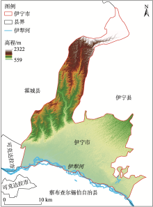
| [1] |
Zhou J B, Liu W Q. Monitoring and evaluation of eco-environment quality based on remote sensing-based ecological index (RSEI) in Taihu Lake Basin, China[J]. Sustainability, 2022, 14(9): 5642, doi: 10.3390/su14095642.
doi: 10.3390/su14095642
|
| [2] |
陈黎鹏. 玛纳斯河流域生态环境质量评价研究[D]. 石河子: 石河子大学, 2020.
|
|
[Chen Lipeng. Study on the ecological environment of Manas River Basin[D]. Shihezi: Shihezi University, 2020.]
|
| [3] |
徐凯磊. 基于多源遥感数据的全国生态环境质量时空演变研究[D]. 北京: 中国矿业大学, 2018.
|
|
[Xu Kailei. Study on spatio-temporal evolution of national ecological environment quality based on multi-source remote sensing data[D]. Beijing: China University of Mining and Technology, 2018.]
|
| [4] |
Guo A D, Yang J, Xiao X G, et al. Influences of urban spatial form on urban heat island effects at the community level in China[J]. Sustainable Cities and Society, 2020, 53(C): 101972, doi: 10.1016/j.scs.2019.101972.
doi: 10.1016/j.scs.2019.101972
|
| [5] |
Tsakiris G, Vangelis H. Establishing a drought index incorporating evapotranspiration[J]. European Water, 2005(9/10): 1-9.
|
| [6] |
Hazbavi Z, Sadeghi S H, Gholamalifard M, et al. Watershed health assessment using the pressure-state-response (PSR) framework[J]. Land Degradation & Development, 2020, 31: 3-19.
doi: 10.1002/ldr.v31.1
|
| [7] |
徐涵秋. 区域生态环境变化的遥感评价指数[J]. 中国环境科学, 2013, 33(5): 889-897.
|
|
[Xu Hanqiu. A remote sensing index for assessment of regional ecological changes[J]. China Environmental Science, 2013, 33(5): 889-897.]
|
| [8] |
Cui R H, Han J Z, Hu Z Q, et al. Assessment of spatial temporal changes of ecological environment quality: A case study in Huaibei City, China[J]. Land, 2022, 11(6): 944, doi: 10.3390/LAND 11060944.
doi: 10.3390/LAND 11060944
|
| [9] |
Zhang J J, Zhou Q, Cao M, et al. Spatiotemporal change of eco-environmental quality in the oasis city and its correlation with urbanization based on RSEI: A case study of Urumqi, China[J]. Sustainability, 2022, 14(15): 9227, doi: 10.3390/su14159227.
doi: 10.3390/su14159227
|
| [10] |
王瑾杰, 丁建丽, 张子鹏. 基于遥感生态指数的吐哈地区生态环境变化研究[J]. 干旱区地理, 2022, 45(5): 1591-1603.
|
|
[Wang Jinjie, Ding Jianli, Zhang Zipeng. Change of ecological environment in Turpan and Hami cities based on remote sensing ecology index[J]. Arid Land Geography, 2022, 45(5): 1591-1603.]
|
| [11] |
农兰萍, 王金亮. 基于RSEI模型的昆明市生态环境质量动态监测[J]. 生态学杂志, 2020, 39(6): 2042-2050.
|
|
[Nong Lanping, Wang Jinliang. Dynamic monitoring of ecological environment quality in Kunming based on RSEI model[J]. Chinese Journal of Ecology, 2020, 39(6): 2042-2050.]
|
| [12] |
Zheng Z, Wu Z F, Chen Y B, et al. Instability of remote sensing based ecological index (RSEI) and its improvement for time series analysis[J]. Science of the Total Environment, 2022, 814: 152595, doi: 10.1016/J.SCITOTENV.2021.152595.
doi: 10.1016/J.SCITOTENV.2021.152595
|
| [13] |
王丽霞, 赵蕊, 刘招, 等. 基于RSEI的延河流域生态环境质量监测与预估[J]. 干旱区研究, 2022, 39(3): 943-954.
|
|
[Wang Lixia, Zhao Rui, Liu Zhao, et al. Monitoring and prediction of ecological environmental quality in the Yanhe River Basin based on the remote sensing ecological index[J]. Arid Zone Research, 2022, 39(3): 943-954.]
|
| [14] |
Rouse J W, Haas R H, Schell J A, et al. Monitoring vegetation systems in the Great Plains with ERTS[J]. Nasa Special Publication, 1974, 351: 309-317.
|
| [15] |
Crist E P. A TM tasseled cap equivalent transformation for reflectance factor data[J]. Remote Sensing of Environment, 1985, 17(3): 301-306.
doi: 10.1016/0034-4257(85)90102-6
|
| [16] |
Baig M H A, Zhang L, Shuai T, et al. Derivation of a tasselled cap transformation based on Landsat 8 at-satellite reflectance[J]. Remote Sensing Letters, 2014, 5(5): 423-431.
doi: 10.1080/2150704X.2014.915434
|
| [17] |
Xu H. A new index for delineating built-up land features in satellite imagery[J]. International Journal of Remote Sensing, 2008, 29(14): 4269-4276.
doi: 10.1080/01431160802039957
|
| [18] |
Essa W, Verbeiren B, van der Kwast J, et al. Evaluation of the distrad thermal sharpening methodology for urban areas[J]. International Journal of Applied Earth Observation and Geoinformation, 2012, 19: 163-172.
doi: 10.1016/j.jag.2012.05.010
|
| [19] |
Jimenez-Munoz J C, Cristobal J, Sobrino J A, et al. Revision of the single-channel algorithm for land surface temperature retrieval from Landsat thermal-infrared data[J]. IEEE Transactions on Geoscience and Remote Sensing, 2009, 47(1-2): 339-349.
doi: 10.1109/TGRS.2008.2007125
|
| [20] |
Sobrino J A, Jiménez-Muñoz J C, Paolini L. Land surface temperature retrieval from Landsat TM 5[J]. Remote Sensing of Environment, 2004, 90(4): 434-440.
doi: 10.1016/j.rse.2004.02.003
|
| [21] |
Weng Q. Thermal infrared remote sensing for urban climate and environmental studies: Methods, applications, and trends[J]. Isprs Journal of Photogrammetry & Remote Sensing, 2009, 64(4): 335-344.
|
| [22] |
Nichol J. Remote sensing of urban heat islands by day and night[J]. Photogrammetric Engineering & Remote Sensing, 2005, 71(5): 613-621.
|
| [23] |
Zhang T, Yang R Q, Yang Y, et al. Assessing the urban eco-environmental quality by the remote-sensing ecological index: Application to Tianjin, north China[J]. International Journal of Geo-information, 2021, 10(7): 475, doi: 10.3390/IJGI10070475.
doi: 10.3390/IJGI10070475
|
| [24] |
贾京默, 孙钊, 桂心如, 等. 基于Ann-CA-Markov模型的鹤岗市农林用地景观格局研究[J]. 林业资源管理, 2022(3): 81-88.
|
|
[Jia Jingmo, Sun Zhao, Gui Xinru, et al. Simulation of landscape pattern of agricultural and forestry land in Hegang City based on Ann-CA-Markov model[J]. Forest Resources Management, 2022(3): 81-88.]
|
| [25] |
欧照铿. Markov约束下ANN-CA模型构建与闽侯县土地利用模拟研究[D]. 福州: 福建农林大学, 2014.
|
|
[Ou Zhaokeng. Study on modeling and simulating of land use based on ANN-CA model under the constraints of Markov in Minhou County[D]. Fuzhou: Fujian Agriculture and Forestry University, 2014.]
|
| [26] |
赵晓峰, 王金林, 王珊珊, 等. 基于MCR模型的卡拉麦里地区生态安全格局变化研究[J]. 干旱区地理, 2021, 44(5): 1396-1406.
|
|
[Zhao Xiaofeng, Wang Jinlin, Wang Shanshan, et al. Changes of ecological security pattern in Kalamaili region based on MCR models[J]. Arid Land Geography, 2021, 44(5): 1396-1406.]
|
| [27] |
靳含, 杨爱民, 夏鑫鑫, 等. 基于CA-Markov模型的多时间跨度土地利用变化模拟[J]. 干旱区地理, 2019, 42(6): 1415-1426.
|
|
[Jin Han, Yang Aimin, Xia Xinxin, et al. Simulation of land use change at different time spans based on CA-Markov model[J]. Arid Land Geography, 2019, 42(6): 1415-1426.]
|
| [28] |
赵林峰, 刘小平, 刘鹏华, 等. 基于地理分区与FLUS模型的城市扩张模拟与预警[J]. 地球信息科学学报, 2020, 22(3): 517-530.
doi: 10.12082/dqxxkx.2020.190477
|
|
[Zhao Linfeng, Liu Xiaoping, Liu Penghua, et al. Urban expansion simulation and early warning based on geospatial partition and FLUS model[J]. Journal of Geo-information Science, 2020, 22(3): 517-530.]
doi: 10.12082/dqxxkx.2020.190477
|
| [29] |
唐利华, 张永福, 刘小辉. 干旱区河谷城市土地利用生态风险动态预测--以新疆伊宁市为例[J]. 水土保持研究, 2016, 23(3): 240-245.
|
|
[Tang Lihua, Zhang Yongfu, Liu Xiaohui. Dynamic forecast of ecological risk of land use in the arid river valley city: A case study of Yining City in Xinjiang Uygur Autonomous Region[J]. Research of Soil and Water Conservation, 2016, 23(3): 240-245.]
|
| [30] |
马鹏, 李志忠, 靳建辉, 等. 基于土地利用的新疆伊犁河谷生态系统服务价值评价[J]. 浙江师范大学学报(自然科学版), 2010, 33(3): 331-335.
|
|
[Ma Peng, Li Zhizhong, Jin Jianhui, et al. Ecosystem service value evaluation based on land use of Yili Valley in Xinjiang[J]. Journal of Zhejiang Normal University (Natural Sciences Edition), 2010, 33(3): 331-335.]
|
| [31] |
肉孜买买提·阿不来提. 新疆伊宁市1952年-2015年气温及降水量变化特征分析[J]. 陕西水利, 2020, 239(12): 20-22, 25.
|
|
[Ablait Ruzimamat. Analysis on the characteristics of temperature and precipitation changes in Yining, Xinjiang from 1952 to 2015[J]. Shaanxi Water Resources, 2020, 239(12): 20-22, 25.]
|
| [32] |
海晓宇. 新疆伊宁市城市市容环境卫生管理研究[D]. 乌鲁木齐: 新疆大学, 2019.
|
|
[Hai Xiaoyu. A study on urban sanitation and environmental sanitation management in Yining City, Xinjiang[D]. Urumqi: Xinjiang University, 2019.]
|
| [33] |
赵禾苗, 阿里木江·卡斯木. 基于GIS的绿洲城市时空扩展特征研究--以新疆伊宁市为例[J]. 湖北农业科学, 2021, 60(14): 109-116.
|
|
[Zhao Hemiao, Kasim Alimujiang. Study on the spatial and temporal expansion characteristics of oasis city based on GIS: Taking Yining City, Xinjiang as an example[J]. Hubei Agricultural Sciences, 2021, 60(14): 109-116.]
|
 ),冯丹1,2(