| [1] |
新华网. 新疆棉花产量占全国90.2%创历史新高[EB/OL]. http://www.news.cn/local/2022-12/27/c_1129236779.htm. 2022-12-27.
|
|
[Xinhua Net. Xinjiang’s cotton production accounts for 90.2% of the country’s total, a record high[EB/OL]. http://www.news.cn/local/2022-12/27/c_1129236779.htm. 2022-12-27. ]
|
| [2] |
胡栩, 聂勇, 徐霞, 等. 塔里木盆地南缘和田地区土地利用变化的遥感研究[J]. 地理科学进展, 2020, 39(4): 577-590.
doi: 10.18306/dlkxjz.2020.04.005
|
|
[Hu Xu, Nie Yong, Xu Xia, et al. Monitoring land-use change in Hetian Tarim Basin, China using satellite remote sensing observation between 1990 and 2016[J]. Progress in Geography, 2020, 39(4): 577-590. ]
doi: 10.18306/dlkxjz.2020.04.005
|
| [3] |
张沛, 龙爱华, 海洋, 等. 1988—2015年新疆农业用水时空变化与政策驱动研究——基于农作物水足迹的统计分析[J]. 冰川冻土, 2021, 43(1): 242-253.
doi: 10.7522/j.issn.1000-0240.2018.1058
|
|
[Zang Pei, Long Aihua, Hai Yang, et al. Spatiotemporal variations and driving forces of agricultural water consumption in Xinjiang during 1988—2015: Based on statistical analysis of crop water footprint[J]. Journal of Glaciology and Geocryology, 2021, 43(1): 242-253. ]
doi: 10.7522/j.issn.1000-0240.2018.1058
|
| [4] |
崔远来, 熊佳. 灌溉水利用效率指标研究进展[J]. 水科学进展, 2009, 20(4): 590-598.
|
|
[Cui Yuanlai, Xiong Jia. Advances in assessment indicators of irrigation water use efficiency[J]. Advances in Water Science, 2009, 20(4): 590-598. ]
|
| [5] |
陈仲新, 郝鹏宇, 刘佳, 等. 农业遥感卫星发展现状及我国监测需求分析[J]. 智慧农业, 2019, 1(1): 32-42.
doi: 10.12133/j.smartag.2019.1.1.201901-SA003
|
|
[Chen Zhongxin, Hao Pengyu, Liu Jia. et al. Technical demands for agricultural remote sensing satellites in China[J]. Smart Agriculture, 2019, 1(1): 32-42. ]
doi: 10.12133/j.smartag.2019.1.1.201901-SA003
|
| [6] |
周柳萍. 基于遥感和气象数据的江苏省水稻水分生产率时空变化研究[D]. 杭州: 浙江大学, 2015.
|
|
[Zhou Liuping. Study on temporal and spatial variation of rice water productivity of Jiangsu Province based on remote sensing and meteorological data[D]. Hangzhou: Zhejiang University, 2015. ]
|
| [7] |
蒋磊, 杨雨亭, 尚松浩. 基于遥感蒸发模型的干旱区灌区灌溉效率评价[J]. 农业工程学报, 2013, 29(20): 95-101.
|
|
[Jiang Lei, Yang Yuting, Shang Songhao. Evaluation on irrigation efficiency of irrigation district in arid region based on evapotranspiration estimated from remote sensing data[J]. Transactions of the Chinese Society of Agricultural Engineering, 2013, 29(20): 95-101. ]
|
| [8] |
杨建莹. 基于SEBAL模型的黄淮海冬小麦和夏玉米水分生产力研究[D]. 北京: 中国农业科学院, 2014.
|
|
[Yang Jianying. Study on water productivity of winter wheat and summer maize based on SEBAL model in Huang-Huai-Hai Plain, China[D]. Beijing: Chinese Academy of Agricultural Sciences, 2014. ]
|
| [9] |
Waldhoff G, Lussem U, Bareth G. Multi-data approach for remote sensing-based regional crop rotation mapping: A case study for the Rur catchment, Germany[J]. International Journal of Applied Earth Observation and Geoinformation, 2017, 61: 55-69.
doi: 10.1016/j.jag.2017.04.009
|
| [10] |
Zhou Q, Zhang Y L, Wu F. Evaluation of the most proper management scale on water use efficiency and water productivity: A case study of the Heihe River Basin, China[J]. Agricultural Water Management, 2021, 246: 106671, doi: org/10.1016/j.agwat.2020.106671.
|
| [11] |
Ghorbanpour A K, Kisekka I, Afshar A, et al. Crop water productivity mapping and benchmarking using remote sensing and Google Earth Engine cloud computing[J]. Remote Sensing, 2022, 14(19): 4934-4934.
doi: 10.3390/rs14194934
|
| [12] |
Mauget S, Ulloa M, Mitchell-McCallister D. Simulated irrigation water productivity and related profit effects in US Southern High Plains cotton production[J]. Agricultural Water Management, 2022, 266: 107582, doi: 10.1016/j.agwat.2022.107582.
|
| [13] |
Chen X P, Qi Z M, Gui D W, et al. Evaluation of a new irrigation decision support system in improving cotton yield and water productivity in an arid climate[J]. Agricultural Water Management, 2020, 234: 106139, doi: 10.1016/j.agwat.2020.106139.
|
| [14] |
Thorp K R, Thompson A L, Bronson K F. Irrigation rate and timing effects on Arizona cotton yield, water productivity, and fiber quality[J]. Agricultural Water Management, 2020, 234: 106146, doi:10.1016/j.agwat.2020.106146.
|
| [15] |
Himanshu S K, Fan Y, Ale S, et al. Simulated efficient growth-stage-based deficit irrigation strategies for maximizing cotton yield, crop water productivity and net returns[J]. Agricultural Water Management, 2021, 250: 106840, doi: 10.1016/j.agwat.2021.106840.
|
| [16] |
柯映明. 近60年来渭干河流域耕地与胡杨的时空演变分析[D]. 北京: 中国科学院, 2020.
|
|
[Ke Yingming. Spatiotemporal evolution analysis of cropland and Populus euphratica in Weigan River Basin in recent 60 years[D]. Beijing: University of Chinese Academy of Sciences, 2020. ]
|
| [17] |
张新焕, 杨德刚, 刘云同. 基于能值的绿洲种植业系统可持续性及敏感性评价——以新疆渭干河流域为例[J]. 生态学报, 2009, 29(11): 6068-6076.
|
|
[Zhang Xinhuan, Yang Degang, Liu Yuntong. Emergy-based sustainability and sensitivity analysis of oasis cropping system: A case study in Weigan River Basin[J]. Acta Ecologica Sinica, 2009, 29(11): 6068-6076. ]
|
| [18] |
Paul M, Rajib A, Negahban-Azar M, et al. Improved agricultural water management in data-scarce semi-arid watersheds: Value of integrating remotely sensed leaf area index in hydrological modeling[J]. Science of the Total Environment, 2021, 791: 148177, doi: 10.1016/j.scitotenv.2021.148177.
|
| [19] |
赵文亮, 贺振, 贺俊平, 等. 基于MODIS-NDVI的河南省冬小麦产量遥感估测[J]. 地理研究, 2012, 31(12): 2310-2320.
doi: 10.11821/yj2012120018
|
|
[Zhao Wenliang, He Zhen, He Junping, et al. Remote sensing estimation for winter wheat yield in Henan based on the MODIS-NDVI data[J]. Geographical Research, 2012, 31(12): 2310-2320. ]
doi: 10.11821/yj2012120018
|
| [20] |
王文静, 张霞, 赵银娣, 等. 综合多特征的Landsat 8时序遥感图像棉花分类方法[J]. 遥感学报, 2017, 21(1): 115-124.
|
|
[Wang Wenjing, Zhang Xia, Zhao Yindi, et al. Cotton extraction method of integrated multi-features based on multi-temporal Landsat 8 images[J]. Journal of Remote Sensing, 2017, 21(1): 115-124. ]
|
| [21] |
田艳君, 石莹, 帅艳民, 等. 基于遥感时序特征的地表覆被信息提取[J]. 干旱区地理, 2021, 44(2): 450-459.
|
|
[Tian Yanjun, Shi Ying, Shuai Yanmin, et al. Land cover information retrieval from temporal features based remote sensing images[J]. Arid Land Geography, 2021, 44(2): 450-459. ]
|
| [22] |
刘雅婷, 龚龑, 段博, 等. 多时相NDVI与丰度综合分析的油菜无人机遥感长势监测[J]. 武汉大学学报(信息科学版), 2020, 45(2): 265-272.
|
|
[Liu Yating, Gong Yan, Duan Bo, et al. Combining multi-temporal NDVI and abundance from UAV remote sensing data for oilseed rape growth monitoring[J]. Geomatics and Information Science of Wuhan University, 2020, 45(2): 265-272. ]
|
| [23] |
刘焕军, 孟令华, 张新乐, 等. 基于时间序列Landsat影像的棉花估产模型[J]. 农业工程学报, 2015, 31(17): 215-220.
|
|
[Liu Huanjun, Meng Linghua, Zhang Xinle, et al. Estimation model of cotton yield with time series Landsat images[J]. Transactions of the Chinese Society of Agricultural Engineering, 2015, 31(17): 215-220. ]
|
| [24] |
高中灵, 徐新刚, 王纪华, 等. 基于时间序列NDVI相似性分析的棉花估产[J]. 农业工程学报, 2012, 28(2): 148-153.
|
|
[Gao Zhongling, Xu Xingang, Wang Jihua, et al. Cotton yield estimation based on similarity analysis of time-series NDVI[J]. Transactions of the Chinese Society of Agricultural Engineering, 2012, 28(2): 148-153. ]
|
| [25] |
Meng H L, Liu H J, Zhang X L, et al. Assessment of the effectiveness of spatiotemporal fusion of multi-source satellite images for cotton yield estimation[J]. Computers and Electronics in Agriculture, 2019, 162: 44-52.
doi: 10.1016/j.compag.2019.04.001
|
| [26] |
刘峻明, 周舟, 和晓彤, 等. 频率直方图与植被指数结合的冬小麦遥感产量估测[J]. 农业工程学报, 2021, 37(23): 145-152.
|
|
[Liu Junming, Zhou Zhou, He Xiaotong, et al. Estimating winter wheat yield under frequency histogram and vegetation index using remote sensing[J]. Transactions of the Chinese Society of Agricultural Engineering, 2021, 37(23): 145-152. ]
|
| [27] |
Cai X L, Sharma B R. Integrating remote sensing, census and weather data for an assessment of rice yield, water consumption and water productivity in the Indo-Gangetic River Basin[J]. Agricultural Water Management, 2010, 97(2): 309-316.
doi: 10.1016/j.agwat.2009.09.021
|
| [28] |
Bastiaanssen W G M, Menenti M, Feddes R A, et al. A remote sensing surface energy balance algorithm for land (SEBAL). 1. Formulation[J]. Journal of Hydrology, 1998, 212-213: 198-212.
|
| [29] |
Bastiaanssen W G M, Ahmad M D, Chemin Y. Satellite surveillance of evaporative depletion across the Indus Basin[J]. Water Resources Research, 2002, 38(12): 9-1-9-9.
|
| [30] |
黄青, 王利民, 滕飞. 利用MODIS-NDVI数据提取新疆棉花播种面积信息及长势监测方法研究[J]. 干旱地区农业研究, 2011, 29(2): 213-217.
|
|
[Huang Qing, Wang Limin, Teng Fei. MODIS-NDVI-based monitoring of cotton planting areas and growth condition in Xinjiang[J]. Agricultural Research in the Arid Areas, 2011, 29(2): 213-217. ]
|
| [31] |
马春玥, 买买提·沙吾提, 姚杰, 等. 1950—2015年中国棉花生产时空动态变化[J]. 地理学报, 2020, 75(8): 1699-1710.
doi: 10.11821/dlxb202008010
|
|
[Ma Chunyue, Sawut Mamat, Yao Jie, et al. Spatio-temporal changes of cotton production in China from 1950 to 2015[J]. Acta Geographica Sinice, 2020, 75(8): 1699-1710. ]
doi: 10.11821/dlxb202008010
|
| [32] |
杨欢, 邓帆, 张佳华, 等. 基于MODIS EVI的江汉平原油菜和冬小麦种植信息提取研究[J]. 国土资源遥感, 2020, 32(3): 208-215.
|
|
[Yang Huan, Deng Fan, Zhang Jiahua, et al. A study of information extraction of rape and winter wheat planting in Jianghan Plain based on MODIS EVI[J]. Remote Sensing for Land and Resources, 2020, 32(3): 208-215. ]
|
| [33] |
Xu C C, Zhang X C, Zhang J X, et al. Estimation of crop water requirement based on planting structure extraction from multi-temporal MODIS EVI[J]. Water Resources Management, 2021, 35: 2231-2247.
doi: 10.1007/s11269-021-02838-y
|
| [34] |
于兵. 作物水分生产率及种植适宜度的遥感评价方法[D]. 北京: 清华大学, 2019.
|
|
[Yu Bing. Remote sensing based assessment method for crop water productivity and planting suitability[D]. Beijing: Tsinghua University, 2019. ]
|
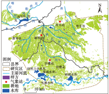
 ),买买提·沙吾提1,2,3(