干旱区地理 ›› 2026, Vol. 49 ›› Issue (10): 2054-2064.doi: 10.12118/j.issn.1000-6060.2025.642 cstr: 32274.14.ALG2025642
马慧芳( ), 王娥, 王艳丽, 孙卓娜, 赵润芳, 张军()
收稿日期:2025-10-18
修回日期:2025-11-12
出版日期:2026-10-25
发布日期:2026-10-26
通讯作者:
张军(1977-),男,博士,教授,主要从事生态系统服务等方面的研究. E-mail: zhangjun@gsau.edu.cn作者简介:马慧芳(2001-),女,硕士研究生,主要从事生态安全等方面的研究. E-mail: mhf13309381493@163.com论文构思:张军、马慧芳、王娥、王艳丽;数据管理:王娥、马慧芳、王艳丽;规范分析:马慧芳、王娥、王艳丽;获取资助:张军;调查研究:马慧芳、王娥、王艳丽、孙卓娜、赵润芳;方法设计:马慧芳、王娥、王艳丽;项目管理:张军;提供资源:马慧芳、王娥、王艳丽、孙卓娜、赵润芳;监督指导:张军;验证复核:张军、马慧芳、王娥;可视化:马慧芳、王娥、王艳丽;初稿撰写:马慧芳、王娥、王艳丽、孙卓娜、赵润芳;修订编辑:张军、马慧芳。
基金资助:
MA Huifang(), WANG E, WANG Yanli, SUN Zhuona, ZHAO Runfang, ZHANG Jun()
Received:2025-10-18
Revised:2025-11-12
Published:2026-10-25
Online:2026-10-26
摘要:
河西地区是我国西北干旱区典型的生态脆弱带,其生态安全对区域及国家的生态安全屏障极为重要。以河西地区为研究对象,综合形态学空间模式分析(MSPA)、生境质量、自然保护区和景观连通性识别生态源地,基于电路理论提取生态廊道与关键节点,构建区域生态安全格局,进而提出以“四区三带”为框架的生态保护修复策略。结果表明:(1) 河西地区核心生态源地14个,总面积11941.29 km2,占区域面积的4.82%,以祁连山区草地为主。核心生态廊道共40条,生态夹点19处,生态障碍点33处。(2) 高潜力生态源地填补了核心生态源地的断点,高潜力生态源地增加至19个,面积增加至25259.22 km2,占比10.20%,同时生态廊道增加至55条,生态夹点和障碍点分别增至21处和36处,显著提升了区域整体的生态连通性。(3) 高潜力生态源地优化后达到核心生态源地的标准,使网络闭合度、线点率与连接度指数分别提升了41.79%、24.17%和23.08%,生态网络连通性显著提升,形成结构稳定的生态安全网络。(4) 结合地理特征和当地政策规划指导,构建了“四区三带”生态安全格局,为干旱区生态安全研究提供科学依据和实践参考。
马慧芳, 王娥, 王艳丽, 孙卓娜, 赵润芳, 张军. “核心-潜力”双源驱动下的河西地区生态安全格局与优化[J]. 干旱区地理, 2026, 49(10): 2054-2064.
MA Huifang, WANG E, WANG Yanli, SUN Zhuona, ZHAO Runfang, ZHANG Jun. Ecological security pattern and optimization in the Hexi region under a “core-potential” dual-source framework[J]. Arid Land Geography, 2026, 49(10): 2054-2064.
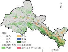
图1
研究区示意图"
表1
数据来源"
| 数据 | 年份 | 分辨率/m | 来源 |
|---|---|---|---|
| 土壤保持/t·km-2 | 2020 | 1000 | https://www.scidb.cn/ |
| 水源涵养/mm | 2020 | 30 | https://www.scidb.cn/ |
| 防风固沙/kg·m-2 | 2020 | 30 | https://www.scidb.cn/ |
| 土地沙化 | 2020 | 90 | https://gis5g.com/home |
| 土地利用 | 2000、2010、2020、2022 | 1000 | https://gis5g.com/home |
| 归一化植被指数 | 2020 | 1000 | https://data.tpdc.ac.cn/ |
| 河流数据 | 2020 | - | https://www.openstreet-map.org/ |
| 道路数据 | 2020 | - | https://www.openstreet-map.org/ |
| MOD09A1 | 2020年8月 | 500 | https://ladsweb.modaps.eosdis.nasa.gov/archive/ |
表2
生态阻力因子分级标准及权重"
| 阻力因子 | 生态扩张阻力分值 | 权重 | ||||
|---|---|---|---|---|---|---|
| 1级 | 2级 | 3级 | 4级 | 5级 | ||
| 土地利用 | 林地、水域 | 草地 | 耕地 | 未利用地 | 建设用地 | 0.32 |
| 归一化植被指数 | 0.8~1.0 | 0.6~0.8 | 0.4~0.6 | 0.2~0.4 | 0.0~0.2 | 0.18 |
| 高程/m | <1610 | 1610~2284 | 2284~3079 | 3079~3884 | >3884 | 0.15 |
| 坡度/(°) | 0~3 | 3~8 | 8~15 | 15~25 | >25 | 0.10 |
| 距道路距离/m | >2000 | 1500~2000 | 1000~1500 | 500~1000 | <500 | 0.09 |
| 距水域距离/m | <1000 | 1000~2000 | 2000~3000 | 3000~4000 | >4000 | 0.16 |
表3
生态源地景观连通性指数"
| 源地类型 | 斑块编号 | dLCP | dIIC | dPC | 斑块编号 | dLCP | dIIC | dPC | 斑块编号 | dLCP | dIIC | dPC |
|---|---|---|---|---|---|---|---|---|---|---|---|---|
| 核心生态源地 | 1 | 1.461 | 0.821 | 1.278 | 6 | 0.035 | 0.032 | 1.274 | 11 | 0.723 | 0.415 | 0.645 |
| 2 | 98.455 | 98.939 | 98.435 | 7 | 5.690 | 1.782 | 3.920 | 12 | 11.989 | 7.089 | 10.674 | |
| 3 | 0.498 | 0.190 | 0.395 | 8 | 9.619 | 3.260 | 2.966 | 13 | 0.019 | 0.013 | 0.506 | |
| 4 | 3.105 | 1.659 | 2.520 | 9 | 10.142 | 3.545 | 0.624 | 14 | 0.289 | 0.088 | 0.206 | |
| 5 | 0.206 | 0.114 | 0.191 | 10 | 0.339 | 0.195 | 0.330 | |||||
| 高潜力生态源地 | A1 | 0.759 | 0.510 | 0.680 | A8 | 0.177 | 0.121 | 0.146 | A15 | 0.103 | 0.069 | 0.094 |
| A2 | 83.165 | 82.238 | 78.505 | A9 | 39.194 | 34.326 | 40.341 | A16 | 11.241 | 5.998 | 9.178 | |
| A3 | 13.519 | 7.259 | 10.937 | A10 | 0.963 | 0.649 | 0.863 | A17 | 0.584 | 0.456 | 1.528 | |
| A4 | 7.384 | 3.722 | 5.868 | A11 | 30.459 | 15.801 | 10.790 | A18 | 0.013 | 0.008 | 0.184 | |
| A5 | 1.800 | 1.251 | 1.489 | A12 | 0.265 | 0.409 | 7.063 | A19 | 0.010 | 0.006 | 0.112 | |
| A6 | 1.214 | 0.826 | 1.158 | A13 | 1.979 | 1.335 | 1.914 | |||||
| A7 | 0.662 | 0.455 | 0.633 | A14 | 0.176 | 0.118 | 0.180 |
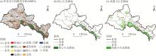
图2
河西地区生态源地分布 注:(a)中的核心区为MSPA识别出的生态源地;(b)和(c)中的数字分别为核心和高潜力生态源地斑块的编号。"
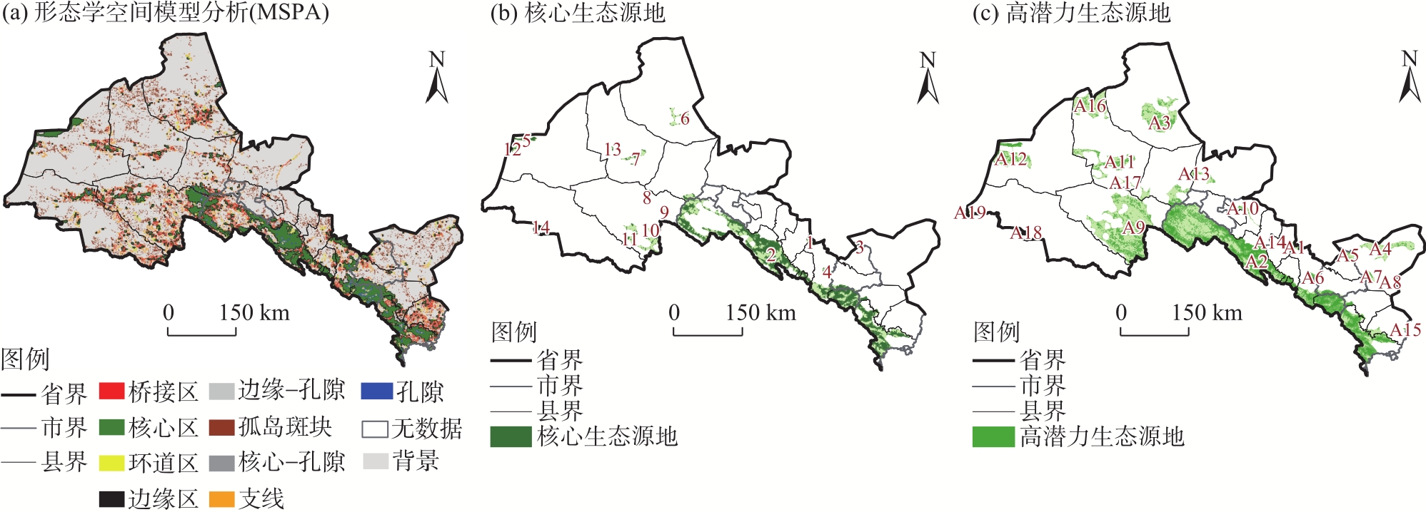
表4
生态源地面积统计"
| 源地类型 | 林地 | 草地 | 水域 | 生态源地 | ||||||||
|---|---|---|---|---|---|---|---|---|---|---|---|---|
| 面积/km2 | 占比/% | 面积/km2 | 占比/% | 面积/km2 | 占比/% | 面积/km2 | 占比/% | 个数 | ||||
| 核心生态源地 | 4031 | 33.99 | 7677 | 64.74 | 105 | 0.89 | 11941.29 | 4.82 | 14 | |||
| 高潜力生态源地 | 5547 | 22.09 | 16394 | 65.30 | 259 | 1.03 | 25259.22 | 10.20 | 19 | |||
图3
河西地区综合阻力面分级"
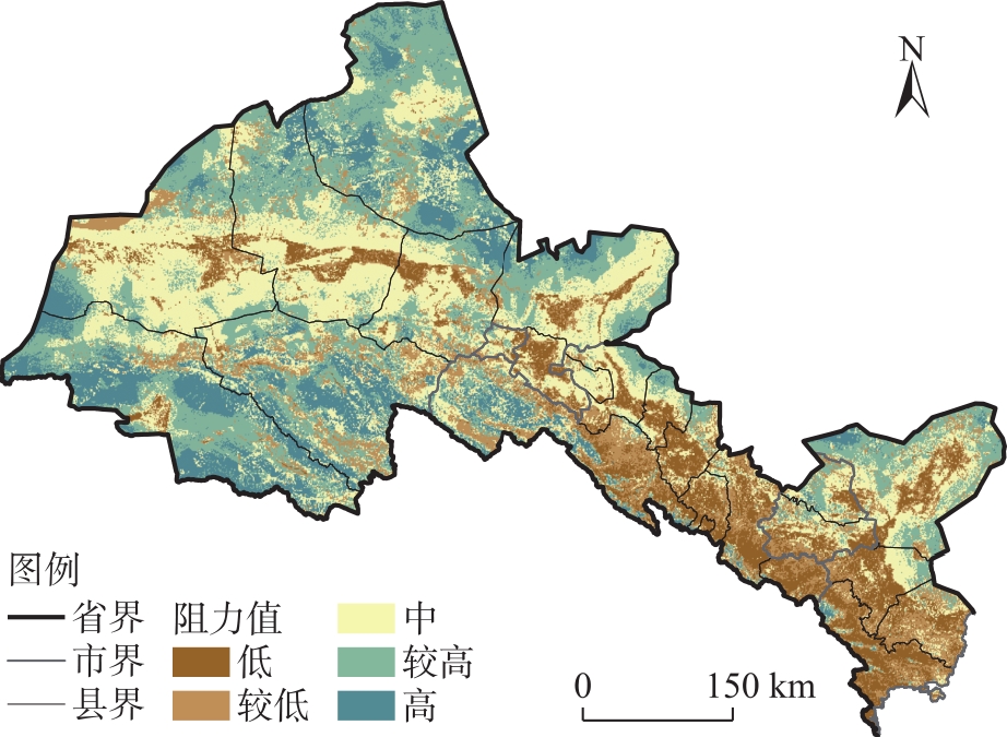
图4
河西地区生态安全网络格局"
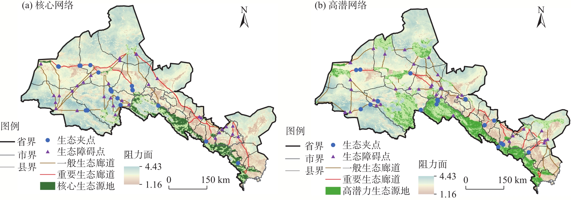
图5
河西生态问题空间分布 注:wc为水源涵养;sdi为土壤盐渍化;ndvi为归一化植被指数;sc为土壤保持量;ld为土地沙化;sp为防风固沙。"
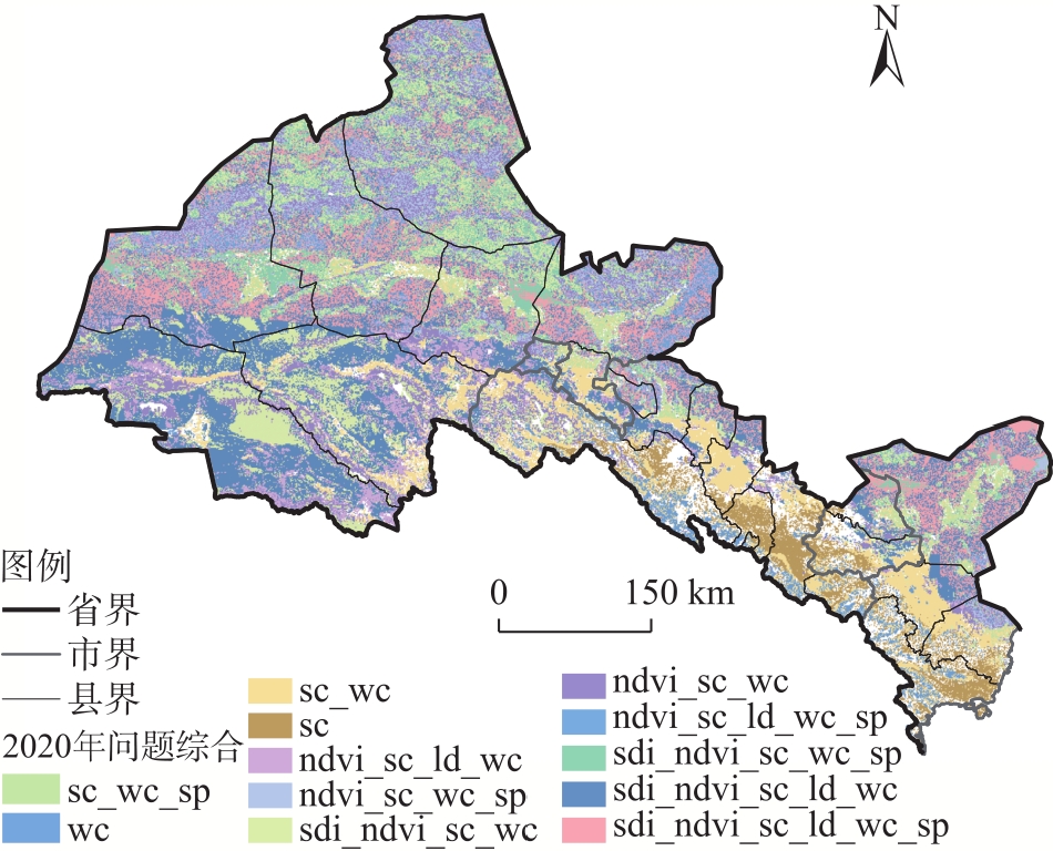
图6
生态保护与修复分区 注:B1~B19为修复斑块的编号。"
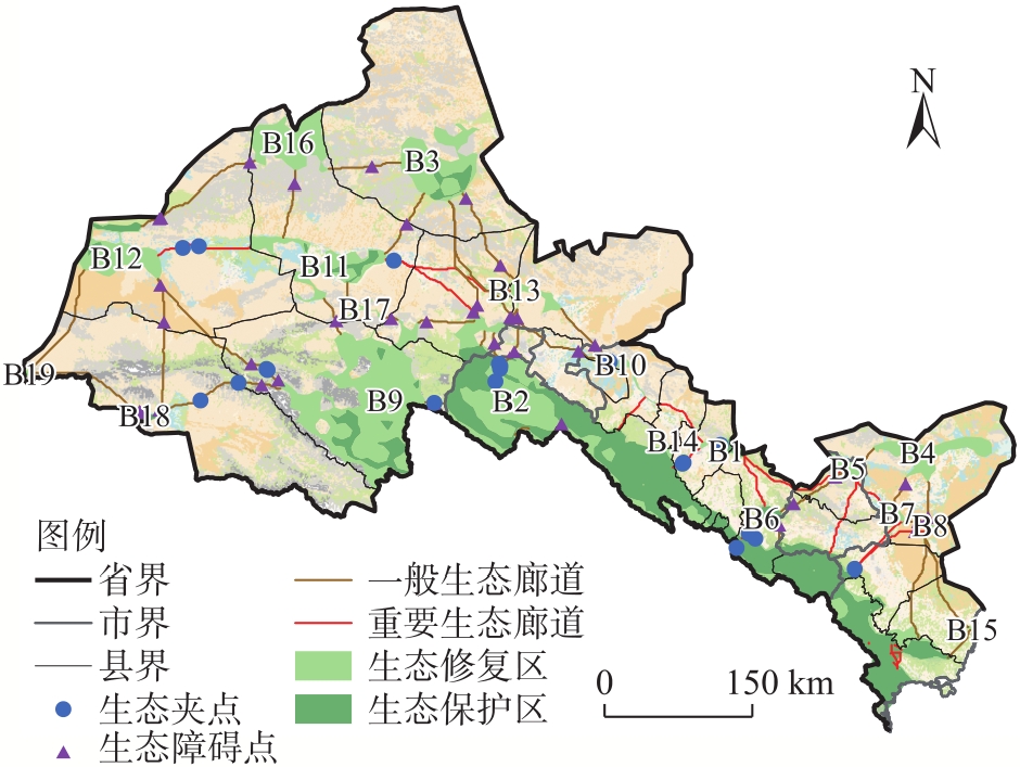
表5
优化前后生态安全网络结构指数"
| 生态网络 | 生态廊道 | 廊道总长/km | 生态夹点 | 闭合度指数(α) | 线点率指数(β) | 连接度指数(γ) | 成本比(R) |
|---|---|---|---|---|---|---|---|
| 核心网络(优化前) | 40 | 4456.31 | 19 | 0.67 | 2.11 | 0.78 | 0.99 |
| 高潜网络(优化后) | 55 | 3574.71 | 21 | 0.95 | 2.62 | 0.96 | 0.98 |
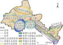
图7
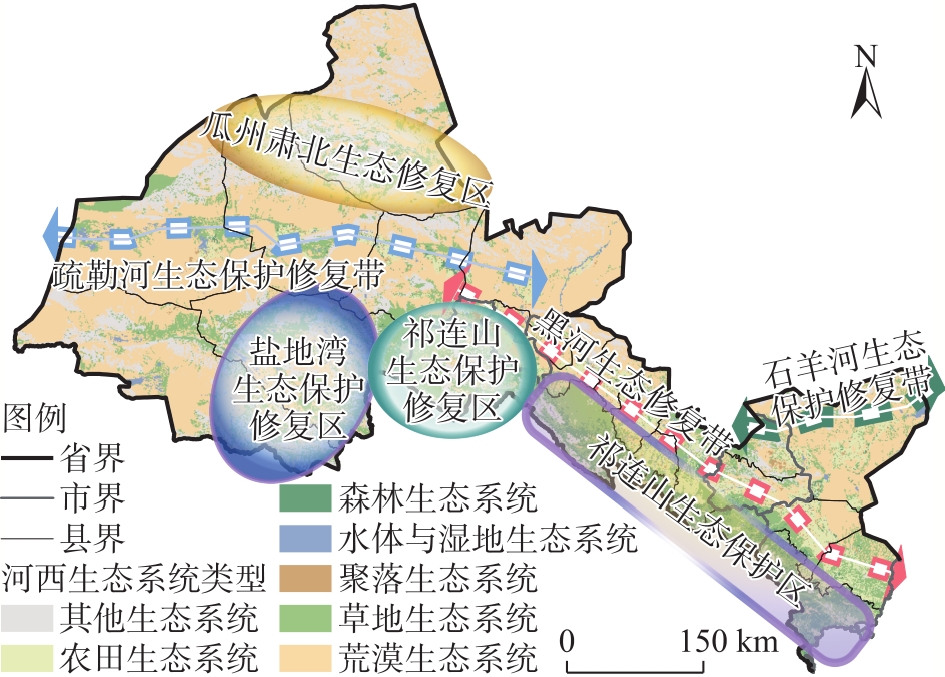
河西地区生态安全规划"
| [1] | 叶鑫, 邹长新, 刘国华, 等. 生态安全格局研究的主要内容与进展[J]. 生态学报, 2018, 38(10): 3382-3392. |
| [Ye Xin, Zou Changxin, Liu Guohua, et al. Main research contents and advances in the ecological security pattern[J]. Acta Ecologica Sinica, 2018, 38(10): 3382-3392. ] | |
| [2] | Chen W H, Liu H M, Wang J L. Construction and optimization of regional ecological security patterns based on MSPA-MCR-GA model: A case study of Dongting Lake Basin in China[J]. Ecological Indicators, 2024, 165: 112169, doi: 10.1016/j.ecolind.2024.112169. |
| [3] | 国务院. 国务院关于印发全国国土规划纲要(2016-2030年)的通知[EB/OL]. [2017-02-04]. https://www.gov.cn/zhengce/content/2017-02/04/content_5165309.htm. |
| [State Council. Notice of the State Council on issuing the national territorial planning outline (2016-2030)[EB/OL]. [2017-02-04]. https://www.gov.cn/zheng-ce/content/2017-02/04/content_5165309.htm.] | |
| [4] | 中共中央办公厅,国务院办公厅. 《关于划定并严守生态保护红线的若干意见》[EB/OL]. [2017-02-07]. https://www.gov.cn/zhengce/2017-02/07/content_5166291.htm. |
| [General Office of the Central Committee of the Communist Party of China, General Office of the State Council. Several opinions on delineating and strictly observing ecological protection red lines[EB/OL]. [2017-02-07]. https://www.gov.cn/zhengce/2017-02/07/content_5166-291.htm.] | |
| [5] | 胡军. 加快建设国家生态安全屏障[EB/OL]. [2025-06-03]. https://theory.people.com.cn/n1/2025/0603/c40531-40492725.html. |
| [Hu Jun. Accelerating the construction of the national ecological security barrier[EB/OL]. [2025-06-03]. https://theory.people.com.cn/n1/2025/0603/c40531-40492725.html.] | |
| [6] | Gong D H, Huang M, Lin H. Construction of an ecological security pattern in rapidly urbanizing areas based on ecosystem sustainability, stability, and integrity[J]. Remote Sensing, 2023, 15(24): 5728, doi: 10.3390/rs15245728. |
| [7] |
Graves R A, Williamson M A, Belote R T, et al. Quantifying the contribution of conservation easements to large-landscape conservation[J]. Biological Conservation, 2019, 232: 83-96.
doi: 10.1016/j.biocon.2019.01.024 |
| [8] | Luo J L, Fu H. Construct the future wetland ecological security pattern with multi-scenario simulation[J]. Ecological Indicators, 2023, 153: 110473, doi: 10.1016/j.ecolind.2023.110473. |
| [9] | Chen Y, Wang J L, Kurbanov E, et al. Ecological security assessment at different spatial scales in central Yunnan Province, China[J]. Plos One, 2022, 17(6): e0270267, doi: 10.1371/journal.pone.0270267. |
| [10] | Cao W Y, Li X B, Lü X, et al. To explore the effectiveness of various ecological security pattern construction methods in many growth situations in the future: A case study of the west Liaohe River Basin in Inner Mongolia[J]. Science of the Total Environment, 2024, 948: 174607, doi: 10.1016/j.scitotenv.2024.174607. |
| [11] | Nie W B, Xu B, Yang F, et al. Simulating future land use by coupling ecological security patterns and multiple scenarios[J]. Science of the Total Environment, 2023, 859: 160262, doi: 10.1016/j.scitotenv.2022.160262. |
| [12] | Pan N H, Du Q Q, Guan Q Y, et al. Ecological security assessment and pattern construction in arid and semi-arid areas: A case study of the Hexi region, NW China[J]. Ecological Indicators, 2022, 138: 108797, doi: 10.1016/j.ecolind.2022.108797. |
| [13] | Huang L Y, Wang J, Cheng H G. Spatiotemporal changes in ecological network resilience in the Shandong Peninsula urban agglomeration[J]. Journal of Cleaner Production, 2022, 339: 130681, doi: 10.1016/j.jclepro.2022.130681. |
| [14] | Li H, Yi N, Yao W J, et al. Shangri-La County ecological land use planning based on landscape security pattern[J]. Acta Ecologica Sinica, 2011, 31(20): 5928-5936. |
| [15] | Zhou G J, Huan Y Z, Wang L Q, et al. Linking ecosystem services and circuit theory to identify priority conservation and restoration areas from an ecological network perspective[J]. Science of the Total Environment, 2023, 873: 162261, doi: 10.1016/j.scitotenv.2023.162261. |
| [16] |
黄秋淞, 何浩. 耦合生态系统服务和景观连通性的环塔里木盆地绿洲区生态安全格局研究[J]. 干旱区地理, 2024, 47(10): 1745-1754.
doi: 10.12118/j.issn.1000-6060.2024.022 |
|
[Huang Qiusong, He Hao. Ecological security pattern of the oasis area around the Tarim Basin based on coupled ecosystem services and landscape connectivity[J]. Arid Land Geography, 2024, 47(10): 1745-1754. ]
doi: 10.12118/j.issn.1000-6060.2024.022 |
|
| [17] | Cui X F, Deng W, Yang J X, et al. Construction and optimization of ecological security patterns based on social equity perspective: A case study in Wuhan, China[J]. Ecological Indicators, 2022, 136: 108714, doi: 10.1016/j.ecolind.2022.108714. |
| [18] |
马晓武, 徐昔保. 区域尺度生态保护红线连通性优化与管控--以长三角为例[J]. 自然资源学报, 2022, 37(12): 3088-3101.
doi: 10.31497/zrzyxb.20221205 |
|
[Ma Xiaowu, Xu Xibao. Optimization and management of the connectivity of ecological red lines at regional scale: A case study of Yangtze River Delta[J]. Journal of Natural Resources, 2022, 37(12): 3088-3101. ]
doi: 10.31497/zrzyxb.20221205 |
|
| [19] |
张杰, 屈建军, 陈海, 等. 基于电路理论的生态安全格局时空演变与影响因素研究--以陕北黄土高原为例[J]. 干旱区地理, 2025, 48(3): 494-505.
doi: 10.12118/j.issn.1000-6060.2024.199 |
|
[Zhang Jie, Qu Jianjun, Chen Hai, et al. Spatial and temporal evolution and influencing factors of ecological security pattern based on circuit theory: A case of Loess Plateau in northern Shaanxi[J]. Arid Land Geography, 2025, 48(3): 494-505. ]
doi: 10.12118/j.issn.1000-6060.2024.199 |
|
| [20] | Wang N N, Zhao Y. Construction of an ecological security pattern in Jiangnan water network area based on an integrated approach: A case study of Gaochun, Nanjing[J]. Ecological Indicators, 2024, 158: 111314, doi: 10.1016/j.ecolind.2023.111314. |
| [21] |
Senf C, Seidl R. Mapping the forest disturbance regimes of Europe[J]. Nature Sustainability, 2021, 4(1): 63-70.
doi: 10.1038/s41893-020-00609-y |
| [22] |
邓晓红, 宋玉琳, 李宗省, 等. 河西地区生态敏感性演变格局及分区治理[J]. 中国沙漠, 2023, 43(5): 232-240.
doi: 10.7522/j.issn.1000-694X.2023.00083 |
|
[Deng Xiaohong, Song Yulin, Li Zongsheng, et al. Evolution pattern of terrestrial ecological sensitivity in the Hexi region and its zoning governance[J]. Journal of Desert Research, 2023, 43(5): 232-240. ]
doi: 10.7522/j.issn.1000-694X.2023.00083 |
|
| [23] | 自然资源部. 《中国陆域生态基础分区(试行)》[EB/OL]. [2023-05-16]. https://www.guoturen.com/wenku-7024. |
| [Ministry of Natural Resources. China’s terrestrial ecological base zoning (trial)[EB/OL]. [2023-05-16]. https://www.guoturen.com/wenku-7024.] | |
| [24] | 薛明月, 吴孟泉, 郑龙啸, 等. 基于电路理论的县域生态安全格局构建: 以山东省栖霞市为例[J]. 生态学杂志, 2024, 43(10): 3223-3232. |
|
[Xue Mingyue, Wu Mengquan, Zheng Longxiao, et al. The construction of county-level ecological security pattern based on circuit theory: A case study in Qixia City, Shandong Province[J]. Chinese Journal of Ecology, 2024, 43(10): 3223-3232. ]
doi: 10.13292/j.1000-4890.202410.021 |
|
| [25] |
Bodin Ö, Saura S. Ranking individual habitat patches as connectivity providers: Integrating network analysis and patch removal experiments[J]. Ecological Modelling, 2010, 221(19): 2393-2405.
doi: 10.1016/j.ecolmodel.2010.06.017 |
| [26] |
Baranyi G, Saura S, Podani J, et al. Contribution of habitat patches to network connectivity: Redundancy and uniqueness of topological indices[J]. Ecological Indicators, 2011, 11(5): 1301-1310.
doi: 10.1016/j.ecolind.2011.02.003 |
| [27] | 陈春娣, 吴胜军, Douglas M C, 等. 阻力赋值对景观连接模拟的影响[J]. 生态学报, 2015, 35(22): 7367-7376. |
| [Chen Chundi, Wu Shengjun, Douglas M C, et al. Effects of changing cost values on landscape connectivity simulation[J]. Acta Ecologica Sinica, 2015, 35(22): 7367-7376. ] | |
| [28] | 潘竟虎, 刘晓. 基于空间主成分和最小累积阻力模型的内陆河景观生态安全评价与格局优化--以张掖市甘州区为例[J]. 应用生态学报, 2015, 26(10): 3126-3136. |
|
[Pan Jinghu, Liu Xiao. Assessment of landscape ecological security and optimization of landscape pattern based on spatial principal component analysis and resistance model in arid inland area: A case study of Ganzhou District, Zhangye City, northwest China[J]. Chinese Journal of Applied Ecology, 2015, 26(10): 3126-3136. ]
pmid: 26995922 |
|
| [29] | 魏柏浩, 阿里木江·卡斯木, 如克亚·热合曼, 等. 天山北坡城市群生态承载力演变与生态敏感性分析[J]. 生态学报, 2023, 43(4): 1399-1411. |
| [Wei Bohao, Kasimu Alimujiang, Reheman Rukya, et al. Ecological carrying capacity evolution and ecological sensitivity analysis of urban agglomeration in the northern slope of the Tianshan Mountains[J]. Acta Ecologica Sinica, 2023, 43(4): 1399-1411. ] | |
| [30] |
金银丽, 周冬梅, 周凡, 等. 疏勒河流域生态安全网络构建及优化[J]. 应用生态学报, 2023, 34(4): 1063-1072.
doi: 10.13287/j.1001-9332.202304.020 |
|
[Jin Yinli, Zhou Dongmei, Zhou Fan, et al. Construction and optimization of ecological security network in the Shule River Basin, China[J]. Chinese Journal of Applied Ecology, 2023, 34(4): 1063-1072. ]
doi: 10.13287/j.1001-9332.202304.020 |
|
| [31] | Ding M M, Liu W, Xiao L, et al. Construction and optimization strategy of ecological security pattern in a rapidly urbanizing region: A case study in central-south China[J]. Ecological Indicators, 2022, 136: 108604, doi: 10.1016/j.ecolind.2022.108604. |
| [32] | Kang J M, Zhang X, Zhu X W, et al. Ecological security pattern: A new idea for balancing regional development and ecological protection. A case study of the Jiaodong Peninsula, China[J]. Global Ecology and Conservation, 2021, 26: e01472, doi: 10.1016/j.gecco.2021.e01472. |
| [33] | 张德魁, 安富博, 赵艳丽, 等. 甘肃河西走廊典型戈壁土壤粒度特征分析[J]. 中国水土保持, 2020(11): 41-45. |
| [Zhang Dekui, An Fubo, Zhao Yanli, et al. Analysis on grain size characteristics of typical Gobi soil in Hexi Corridor of Gansu Province[J]. Soil and Water Conservation in China, 2020(11): 41-45. ] | |
| [34] | 曹巍, 黄麟, 肖桐, 等. 人类活动对中国国家级自然保护区生态系统的影响[J]. 生态学报, 2019, 39(4): 1338-1350. |
| [Cao Wei, Huang Lin, Xiao Tong, et al. Effects of human activities on the ecosystems of China’s National Nature Reserves[J]. Acta Ecologica Sinica, 2019, 39(4): 1338-1350. ] | |
| [35] | 杨艳敏, 王晓泾. 张掖民乐: 祁连山下重披绿衣退耕还林还草累计完成逾22万亩[EB/OL]. [2023-06-15]. https://www.gs.chinanews.com.cn/news/2023/06-15/361047.shtml. |
| [Yang Yanmin, Wang Xiaojing. Zhangye Minle: Forests and grasslands returned to nature under Qilian Mountains, with over 220000 mu restored[EB/OL]. [2023-06-15]. https://www.gs.chinanews.com.cn/news/2023/06-15/361047.shtml.] | |
| [36] | 新华社. 密织“格子衫”沙漠大“锁边”-甘肃吹响河西走廊-塔克拉玛干沙漠边缘阻击战冲锋号[EB/OL]. [2025-03-13]. https://www.gs.gov.cn/gsszf/c100002/c100011/202503/174096597.shtml. |
| [Xinhua News Agency. Weaving a tight ‘checkered shirt’ across the desert’s edges: Gansu sounds the charge for the battle to secure the Hexi Corridor-Taklamakan Desert frontier[EB/OL]. [2025-03-13]. https://www.gs.gov.cn/gsszf/c100002/c100011/202503/1740-96597.shtml.] | |
| [37] | 鲁明. 甘肃: “四大技术”支撑盐碱地治理利用稳步推进[EB/OL]. [2024-01-08]. https://www.rmzxw.com.cn/c/2024-01-08/3472664.shtml. |
| [Lu Ming. Gansu: Four key technologies underpin steady progress in saline-alkali land management and utilisation[EB/OL]. [2024-01-08]. https://www.rmzxw.com.cn/c/2024-01-08/3472664.shtml.] | |
| [38] | 董文龙, 张花. 风沙线上筑起“绿色长城”--酒泉市持续推进生态文明建设综述[EB/OL]. [2025-05-16]. https://www.gs.gov.cn/gsszf/c100002/c100006/c100008/202505/174141431.shtml. |
| [Dong Wenlong, Zhang Hua. Building a “Green Great Wall” along the wind and sand frontline: An overview of Jiuquan City’s sustained advancement in ecological civilisation construction[EB/OL]. [2025-05-16]. https://www.gs.gov.cn/gsszf/c100002/c100006/c100-008/202505/174141431.shtml.] |
| [1] | 闫晓梅, 王宏卫, 罗魁, 董康宁, 郭瑞杰, 郑旭东. 基于生态安全格局确定县域生物多样性保护的优先区域——以布尔津县为例[J]. 干旱区地理, 2025, 48(4): 586-598. |
| [2] | 张杰, 屈建军, 陈海, 石金鑫, 马羽赫, 刘迪. 基于电路理论的生态安全格局时空演变与影响因素研究——以陕北黄土高原为例[J]. 干旱区地理, 2025, 48(3): 494-505. |
| [3] | 黄秋淞, 何浩. 耦合生态系统服务和景观连通性的环塔里木盆地绿洲区生态安全格局研究[J]. 干旱区地理, 2024, 47(10): 1745-1754. |
| [4] | 李洪庆,杨瑀,张俊红. 雅鲁藏布江山南宽谷流域生态安全格局构建[J]. 干旱区地理, 2023, 46(9): 1503-1513. |
| [5] | 田柳兰, 王珊珊, 毋兆鹏. 基于多时相遥感数据的乌鲁木齐市生态安全格局构建[J]. 干旱区地理, 2023, 46(7): 1155-1165. |
| [6] | 张晓东,赵志鹏,赵银鑫,高学花,马玉学,刘乃静,吉卫波. 银川市景观生态风险评价与生态安全格局优化构建[J]. 干旱区地理, 2022, 45(5): 1626-1636. |
| [7] | 李伊彤,荣丽华,李文龙,程磊. 生态重要性视角下东北林区县域生态安全格局研究——以呼伦贝尔市阿荣旗为例[J]. 干旱区地理, 2022, 45(5): 1615-1625. |
| [8] | 张萌,刘吉平,赵丹丹. 吉林省西部生态安全格局构建[J]. 干旱区地理, 2021, 44(6): 1676-1685. |
| [9] | 杨振民,刘新平. 新疆阿克苏河流域生态承载力监测及安全格局构建[J]. 干旱区地理, 2021, 44(5): 1489-1499. |
| [10] | 赵晓峰,王金林,王珊珊,王权. 基于MCR模型的卡拉麦里地区生态安全格局变化研究[J]. 干旱区地理, 2021, 44(5): 1396-1406. |
| [11] | 马俊, 牟雪松, 王永达, 刘文浩, 范育新. 近1 ka以来河西地区的沙漠化及对高强度人类活动的响应分析[J]. 干旱区地理, 2018, 41(5): 1043-1052. |
| [12] | 张玉虎,李义禄,贾海峰. 永定河流域门头沟区景观生态安全格局评价[J]. 干旱区地理, 2013, 36(6): 1049-1057. |
| [13] | 韩兰英,万信,方峰,张正偲. 甘肃河西地区沙漠化遥感监测评估[J]. 干旱区地理, 2013, 36(1): 131-138. |
| [14] | 张勃, 张华. 河西地区土地利用/覆盖变化驱动力研究[J]. 干旱区地理, 2004, 27(2): 234-238. |
| [15] | 韦志刚, 王尧奇. 河西地区的散射辐射[J]. 干旱区地理, 1994, 17(1): 53-56. |
|
||