干旱区地理 ›› 2023, Vol. 46 ›› Issue (3): 481-491.doi: 10.12118/j.issn.1000-6060.2022.345
程静1( ),王鹏2,陈红翔1(),韩永贵1
收稿日期:2022-07-08
修回日期:2022-09-14
出版日期:2023-03-25
发布日期:2023-03-31
通讯作者:
陈红翔
作者简介:程静(1995-),女,硕士,助教,主要从事生态经济与生态评估研究. E-mail: 基金资助:
CHENG Jing1(),WANG Peng2,CHEN Hongxiang1(),HAN Yonggui1
Received:2022-07-08
Revised:2022-09-14
Online:2023-03-25
Published:2023-03-31
Contact:
Hongxiang CHEN
摘要:
生境质量是关乎人类福祉和区域可持续发展的重要基础,对保护生物多样性、提升生态系统服务功能以及构建区域生态安全格局具有重要意义。基于2000—2020年3期土地利用数据,综合应用InVEST模型、地形位指数、地理探测器及空间统计分析等方法,对渭河流域生境质量空间分布特征及其地形梯度效应与影响因素进行综合分析。结果表明:(1) 2000—2020年渭河流域生境质量指数呈逐年增加态势,由0.607增长至0.624,增长幅度为2.463%,空间上呈现出两极化分布格局,低等和高等生境质量面积持续增加,而中等和良好生境质量面积有所下降。(2) 渭河流域生境质量空间分布受地形因素影响较大,具有显著的地形梯度效应,低等生境质量在低地形梯度上分布广泛,分布指数最高,而高等生境质量在高地形梯度上占据主导优势。(3) 土地利用类型是渭河流域生境质量空间分异的主要影响因素,且任意2个因子对生境质量空间分异的交互作用均大于单个驱动因子的作用,土地利用类型与降雨量、气温、海拔、归一化植被指数的交互决定力均大于0.6。研究结果可为渭河流域可持续发展以及生态保护与高质量发展提供科学的理论支撑与决策支持。
程静,王鹏,陈红翔,韩永贵. 渭河流域生境质量时空演变及其地形梯度效应与影响因素[J]. 干旱区地理, 2023, 46(3): 481-491.
CHENG Jing,WANG Peng,CHEN Hongxiang,HAN Yonggui. Spatiotemporal evolution of habitat quality in the Weihe River Basin and its topographic gradient effects and influencing factors[J]. Arid Land Geography, 2023, 46(3): 481-491.
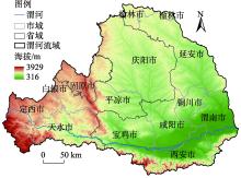
图1
研究区地理位置"

表1
威胁因子最大影响距离及权重"
| 威胁因子 | 最大胁迫距离/km | 权重 | 空间衰退类型 |
|---|---|---|---|
| 城镇用地 | 10 | 1.0 | 指数 |
| 农村居民点 | 8 | 0.6 | 指数 |
| 其他建设用地 | 9 | 0.7 | 指数 |
| 耕地 | 4 | 0.6 | 线性 |
| 未利用地 | 6 | 0.5 | 线性 |
表2
不同土地利用类型对生境威胁因子的敏感度"
| 土地利用类型 | 生境适宜度 | 胁迫因子敏感度 | ||||
|---|---|---|---|---|---|---|
| 城镇用地 | 农村居民点 | 其他建设用地 | 耕地 | 未利用地 | ||
| 耕地 | 0.3 | 0.8 | 0.6 | 0.7 | 0.0 | 0.4 |
| 林地 | 1.0 | 0.8 | 0.7 | 0.5 | 0.6 | 0.2 |
| 草地 | 0.9 | 0.7 | 0.5 | 0.6 | 0.8 | 0.6 |
| 水域 | 0.7 | 0.7 | 0.6 | 0.7 | 0.5 | 0.4 |
| 建设用地 | 0.0 | 0.0 | 0.0 | 0.0 | 0.0 | 0.1 |
| 未利用地 | 0.5 | 0.6 | 0.5 | 0.5 | 0.6 | 0.0 |
表3
地理探测器的驱动因子分级说明"
| 驱动因子 | 分级方法 | 级别 | 级别说明 |
|---|---|---|---|
| 归一化植被指数(NDVI) | 郭帅[ | 1~6 | 1:≤0.2;2:0.2~0.3;3:0.3~0.4;4:0.4~0.5;5:0.5~0.6;6:>0.6 |
| 坡度(SL)/(°) | NaturalBreaks | 1~6 | 1:0~5;2:6~10;3:11~15;4:16~20;5:21~25;6:>25 |
| 海拔(EL)/m | NaturalBreaks | 1~6 | 通过ArcGIS 10.2的Arc Toolbox/Spatial Analyst Tools/Reclass工具提取 |
| 气温(TEM)/℃ | NaturalBreaks | 1~5 | 通过ArcGIS 10.2的Arc Toolbox/Spatial Analyst Tools/Reclass工具提取 |
| 降水(PRE)/mm | NaturalBreaks | 1~5 | 通过ArcGIS 10.2的Arc Toolbox/Spatial Analyst Tools/Reclass工具提取 |
| 土地利用类型(LUT) | 程静[ | 1~6 | 通过ArcGIS 10.2的Arc Toolbox/Spatial Analyst Tools/Reclass工具提取 |
| 土地利用程度(LUD) | NaturalBreaks | 1~5 | 通过ArcGIS 10.2的Arc Toolbox/Spatial Analyst Tools/Reclass工具提取 |
| 人口密度(POP)/人·km-2 | 葛美玲[ | 1~5 | 1:0~60;2:61~150;3:151~300;4:301~500;5:>500 |
| 地区生产总值(GDP)/元 | NaturalBreaks | 1~5 | 通过ArcGIS 10.2的Arc Toolbox/Spatial Analyst Tools/Reclass工具提取 |
表4
渭河流域不同等级生境质量面积及占比变化"
| 生境质量等级 | 2000年 | 2010年 | 2020年 | |||||
|---|---|---|---|---|---|---|---|---|
| 面积/km2 | 占比/% | 面积/km2 | 占比/% | 面积/km2 | 占比/% | |||
| 低等 | 3879.74 | 2.89 | 4660.38 | 3.47 | 5388.63 | 4.02 | ||
| 中等 | 58799.54 | 43.81 | 55990.10 | 41.72 | 54379.37 | 40.52 | ||
| 良好 | 2838.23 | 2.12 | 2483.82 | 1.85 | 2460.84 | 1.83 | ||
| 高等 | 68688.38 | 51.18 | 71071.59 | 52.96 | 71977.05 | 53.63 | ||
| 生境质量平均值 | 0.607 | 0.619 | 0.624 | |||||
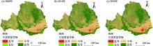
图2
2000—2020年渭河流域生境质量空间分布格局"
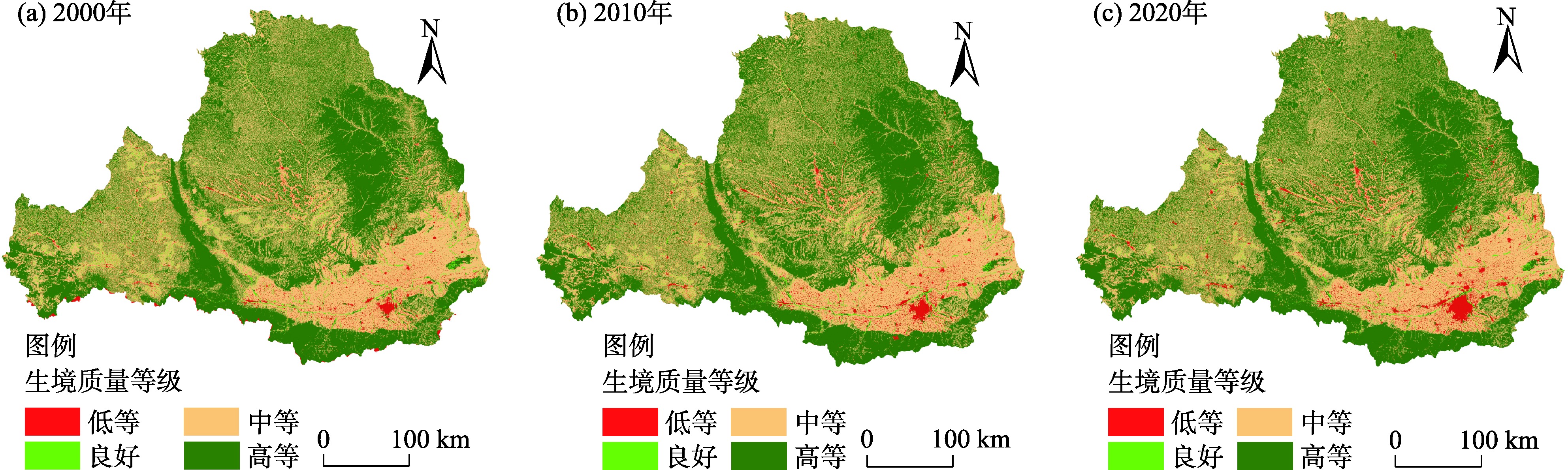
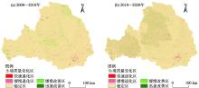
图3
2000—2020年渭河流域生境质量空间变化"

表5
2000—2020年渭河流域生境质量面积及占比变化"
| 类型 | 2000—2010年 | 2010—2020年 | |||
|---|---|---|---|---|---|
| 面积/km2 | 占比/% | 面积/km2 | 占比/% | ||
| 快速退化型 | 348.07 | 0.26 | 994.03 | 0.74 | |
| 缓慢退化型 | 2581.92 | 1.92 | 7207.75 | 5.37 | |
| 稳定型 | 127360.19 | 94.89 | 117630.79 | 87.65 | |
| 缓慢改善型 | 3221.43 | 2.41 | 7415.45 | 5.53 | |
| 快速改善型 | 694.28 | 0.52 | 957.87 | 0.71 | |
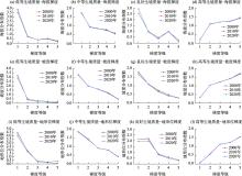
图4
2000—2020年渭河流域生境质量地形梯度分布特征"
表6
生境质量空间分异影响因素探测值"
| 影响因素 | 归一化植被指数 (NDVI) | 降水 (PRE) | 气温 (TEM) | 坡度 (SL) | 海拔 (EL) | 土地利用类型 (LUT) | 土地利用程度 (LUD) | 人口密度 (POP) | 地区生产总值 (GDP) |
|---|---|---|---|---|---|---|---|---|---|
| q值 | 0.37 | 0.43 | 0.41 | 0.29 | 0.36 | 0.49 | 0.32 | 0.21 | 0.24 |
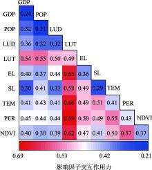
图5
生境质量空间分异特征影响因素的交互作用 注:GDP为地区生产总值;POP为人口密度;LUD为土地利用程度;LUT为土地利用类型;EL为海拔;SL为坡度;TEM为气温;PER为降水;NDVI为归一化植被指数。"

| [1] |
Terrado M, Sabater S, Kramer B C, et al. Model development for the assessment of terrestrial and aquatic habitat quality in conservation planning[J]. Science of the Total Environment, 2015, 540: 63-70.
doi: 10.1016/j.scitotenv.2015.03.064 |
| [2] |
Hillard E M, Nielsen C K, Groninger J W. Swamp rabbits as indicators of wildlife habitat quality in bottom land hardwood forest ecosystems[J]. Ecological Indicators, 2017, 79: 47-53, doi: 10.1016/j.ecolind.2017.03.024.
doi: 10.1016/j.ecolind.2017.03.024 |
| [3] | 刘园, 周勇, 杜越天. 基于InVEST模型的长江中游经济带生境质量的时空分异特征及其地形梯度效应[J]. 长江流域资源与环境, 2019, 28(10): 2429-2440. |
| [ Liu Yuan, Zhou Yong, Du Yuetian. Study on the spatio-temporal patterns of habitat quality and its terrain gradient effects of the middle of the Yangtze River economic belt based on InVEST Model[J]. Resources and Environment in the Yangtze Basin, 2019, 28(10): 2429-2440. ] | |
| [4] |
赵雪雁, 马平易, 李文青, 等. 黄土高原生态系统服务供需关系的时空变化[J]. 地理学报, 2021, 76(11): 2780-2796.
doi: 10.11821/dlxb202111013 |
|
[ Zhao Xueyan, Ma Pingyi, Li Wenqing, et al. Spatiotemporal changes of supply and demand relationships of ecosystem services in the Loess Plateau[J]. Acta Geographica Sinica, 2021, 76(11): 2780-2796. ]
doi: 10.11821/dlxb202111013 |
|
| [5] | 钟莉娜, 王军. 基于InVEST模型评估土地整治对生境质量的影响[J]. 农业工程学报, 2017, 33(1): 250-255. |
| [ Zhong Lina, Wang Jun. Evaluation on effect of land consolidation on habitat quality based on InVEST model[J]. Transactions of the Chinese Society of Agricultural Engineering, 2017, 33(1): 250-255. ] | |
| [6] |
张学儒, 周杰, 李梦梅. 基于土地利用格局重建的区域生境质量时空变化分析[J]. 地理学报, 2020, 75(1): 160-178.
doi: 10.11821/dlxb202001012 |
|
[ Zhang Xueru, Zhou Jie, Li Mengmei. Analysis on spatial and temporal changes of regional habitat quality based on the spatial pattern reconstruction of land use[J]. Acta Geographica Sinica, 2020, 75(1): 160-178. ]
doi: 10.11821/dlxb202001012 |
|
| [7] |
Li Q, Zhou Y, Mary A C, et al. Spatio-temporal changes in wildlife habitat quality in the middle and lower reaches of the Yangtze River from 1980 to 2100 based on the InVEST model[J]. Journal of Resources and Ecology, 2021, 12: 43-55.
doi: 10.5814/j.issn.1674-764x.2021.01.005 |
| [8] | 陈淼, 苏晓磊, 黄慧敏, 等. 三峡库区河流生境质量评价[J]. 生态学报, 2019, 39(1): 192-201. |
| [ Chen Miao, Su Xiaolei, Huang Huimin, et al. Assessment of river habitat quality in the Three Gorges Reservoir Region[J]. Acta Ecologica Sinica, 2019, 39(1): 192-201. ] | |
| [9] |
Tang F, Fu M C, Wang L, et al. Land-use change in Changli County, China: Predicting its spatio-temporal evolution in habitat quality[J]. Ecological Indicators, 2020, 117: 106719, doi: 10.1016/j.ecolind.2020.106719.
doi: 10.1016/j.ecolind.2020.106719 |
| [10] | 朱增云, 阿里木江·卡斯木. 基于地理探测器的伊犁谷地生境质量时空演变及其影响因素[J]. 生态学杂志, 2020, 39(10): 3408-3420. |
| [ Zhu Zengyun, Kasimu Alimujiang. Spatial-temporal evolution of habitat quality in Yili Valley based on geographical detector and its influencing factors[J]. Chinese Journal of Ecology, 2020, 39(10): 3408-3420. ] | |
| [11] | 贾磊, 姚顺波, 邓元杰, 等. 2000—2020年陕西秦巴山区生境质量时空演变及其地形梯度效应[J]. 长江流域资源与环境, 2022, 31(2): 398-413. |
| [ Jia Lei, Yao Shunbo, Deng Yuanjie, et al. Temporal and spatial evolution of habitat quality and its topographic gradient effect in Qinling-Daba Mountain area, Shaanxi Province, 2000—2020[J]. Resources and Environment in the Yangtze Basin, 2022, 31(2): 398-413. ] | |
| [12] | 王军, 严有龙, 王金满, 等. 闽江流域生境质量时空演变特征与预测研究[J]. 生态学报, 2021, 41(14): 5837-5848. |
| [ Wang Jun, Yan Youlong, Wang Jinman, et al. Temporal-spatial variation characteristics and prediction of habitat quality in Min River Basin[J]. Acta Ecologica Sinica, 2021, 41(14): 5837-5848. ] | |
| [13] | 高庆彦, 潘玉君, 刘化. 基于InVEST模型的大理州生境质量时空演化研究[J]. 生态与农村环境学报, 2021, 37(3): 402-408. |
| [ Gao Qingyan, Pan Yujun, Liu Hua. Spatial-temporal evolution of habitat quality in the Dali Bai Autonomous Prefecture based on the InVEST model[J]. Journal of Ecology and Rural Environment, 2021, 37(3): 402-408. ] | |
| [14] |
白立敏, 冯兴华, 孙瑞丰, 等. 生境质量对城镇化的时空响应——以长春市为例[J]. 应用生态学报, 2020, 31(4): 1267-1277.
doi: 10.13287/j.1001-9332.202004.012 |
|
[ Bai Limin, Feng Xinghua, Sun Ruifeng, et al. Spatial and temporal responses of habitat quality to urbanization: A case study of Changchun City, Jilin Province, China[J]. Chinese Journal of Applied Ecology, 2020, 31(4): 1267-1277. ]
doi: 10.13287/j.1001-9332.202004.012 |
|
| [15] | 常玉旸, 高阳, 谢臻, 等. 京津冀地区生境质量与景观格局演变及关联性[J]. 中国环境科学, 2021, 41(2): 848-859. |
| [ Chang Yuyang, Gao Yang, Xie Zhen, et al. Spatiotemporal evolution and spatial correlation of habitat quality and landscape pattern over Beijing-Tianjin-Hebei region[J]. China Environmental Science, 2021, 41(2): 848-859. ] | |
| [16] | 徐彩仙, 巩杰, 李焱, 等. 基于地形梯度的甘肃白龙江流域典型生态系统服务分布特征[J]. 生态学报, 2020, 40(13): 4291-4301. |
| [ Xu Caixian, Gong Jie, Li Yan, et al. Spatial distribution characteristics of typical ecosystem services based on terrain gradients of Bailongjiang watershed in Gansu[J]. Acta Ecologica Sinica, 2020, 40(13): 4291-4301. ] | |
| [17] |
徐省超, 赵雪雁, 宋晓谕. 退耕还林(草)工程对渭河流域生态系统服务的影响[J]. 应用生态学报, 2021, 32(11): 3893-3904.
doi: 10.13287/j.1001-9332.202111.005 |
|
[ Xu Xingchao, Zhao Xueyan, Song Xiaoyu. Impacts of the returning farmland to forest (grassland) project on ecosystem services in the Weihe River Basin, China[J]. Chinese Journal of Applied Ecology, 2021, 32(11): 3893-3904. ]
doi: 10.13287/j.1001-9332.202111.005 |
|
| [18] |
Yan H M, Liu F, Liu J Y, et al. Status of land use intensity in China and its impacts on land carrying capacity[J]. Journal of Geographical Sciences, 2017, 27(4): 387-402.
doi: 10.1007/s11442-017-1383-7 |
| [19] | 石小伟, 冯广京, 苏培添, 等. 大都市郊区土地利用时空演变特征与生境质量评价[J]. 农业工程学报, 2021, 37(4): 275-284. |
| [ Shi Xiaowei, Feng Guangjing, Su Peitian, et al. Spatiotemporal evolution of land use and habitat quality assessment in the suburbs of metropolitan[J]. Transactions of the Chinese Society of Agricultural Engineering, 2021, 37(4): 275-284. ] | |
| [20] |
张学儒, 周杰, 李梦梅. 基于土地利用格局重建的区域生境质量时空变化分析[J]. 地理学报, 2020, 75(1): 160-178.
doi: 10.11821/dlxb202001012 |
|
[ Zhang Xueru, Zhou Jie, Li Mengmei. Analysis on spatial and temporal changes of regional habitat quality based on the spatial pattern reconstruction of land use[J]. Acta Geographica Sinica, 2020, 75(1): 160-178. ]
doi: 10.11821/dlxb202001012 |
|
| [21] | 赵益祯, 曹建农, 张晓栋, 等. 宝塔区土地利用的地形梯度效应与空间格局[J]. 干旱区地理, 2020, 43(5): 1307-1315. |
| [ Zhao Yizhen, Cao Jiannong, Zhang Xiaodong, et al. Topographic gradient effect and spatial pattern of land use in Baota district[J]. Arid Land Geography, 2020, 43(5): 1307-1315. ] | |
| [22] | 周启刚, 陈丹. 重庆山地都市区土地利用地形特征分异研究[J]. 水土保持研究, 2013, 20(3): 86-91. |
| [ Zhou Qigang, Chen Dan. Researched on the topographic differentiation of land use in Chongqing mountainous metropolitan area[J]. Research of Soil and Water Conservation, 2013, 20(3): 86-91. ] | |
| [23] |
宋戈, 王盼盼. 松嫩高平原县域土地利用空间格局地形梯度特征分析——以巴彦县为例[J]. 地理科学, 2017, 37(8): 1218-1225.
doi: 10.13249/j.cnki.sgs.2017.08.012 |
|
[ Song Ge, Wang Panpan. Spatial pattern of land use along the terrain gradient of county in Songnen High Plain: A case study of Bayan County[J]. Scientia Geographica Sinica, 2017, 37(8): 1218-1225. ]
doi: 10.13249/j.cnki.sgs.2017.08.012 |
|
| [24] |
王劲峰, 徐成东. 地理探测器: 原理与展望[J]. 地理学报, 2017, 72(1): 116-134.
doi: 10.11821/dlxb201701010 |
|
[ Wang Jinfeng, Xu Chengdong. Geodetector: Principle and prospective[J]. Acta Geographica Sinica, 2017, 72(1): 116-134. ]
doi: 10.11821/dlxb201701010 |
|
| [25] | 王鹏, 王亚娟, 刘小鹏, 等. 基于景观结构的生态移民安置区生态风险评价——以宁夏红寺堡区为例[J]. 生态学报, 2018, 38(8): 2672-2682. |
| [ Wang Peng, Wang Yajuan, Liu Xiaopeng, et al. Ecological risk assessment of an ecological migrant resettlement region based on landscape structure: A case study of Hongsibu in Ningxia[J]. Acta Ecologica Sinica, 2018, 38(8): 2672-2682. ] | |
| [26] | 郭帅, 裴艳茜, 胡胜, 等. 黄河流域植被指数对气候变化的响应及其与水沙变化的关系[J]. 水土保持通报, 2020, 40(3): 1-7. |
| [ Guo Shuai, Pei Yanqian, Hu Sheng, et al. Response of vegetation index to climate change and their relationship with runoff-sediment change in Yellow River Basin[J]. Bulletin of Soil and Water Conservation, 2020, 40(3): 1-7. ] | |
| [27] | 程静, 王鹏, 陈红翔, 等. 半干旱区生态风险时空演变及其影响因素的地理探测——以宁夏盐池县为例[J]. 干旱区地理, 2022, 45(5): 1637-1648. |
| [ Cheng Jing, Wang Peng, Chen Hongxiang, et al. Geographical exploration of the spatial and temporal evolution of ecological risk and its influencing factors in semi-arid regions[J]. Arid Land Geography, 2022, 45(5): 1637-1648. ] | |
| [28] |
葛美玲, 封志明. 中国人口分布的密度分级与重心曲线特征分析[J]. 地理学报, 2009, 64(2): 202-210.
doi: 10.11821/xb200902007 |
|
[ Ge Meiling, Feng Zhiming. Population distribution of China based on GIS: Classification of population densities and curve of population gravity centers[J]. Acta Geographica Sinica, 2009, 64(2): 202-210. ]
doi: 10.11821/xb200902007 |
|
| [29] | 李子, 张艳芳. 基于InVEST模型的渭河流域干支流生态系统服务时空演变特征分析[J]. 水土保持学报, 2021, 35(4): 178-185. |
| [ Li Zi, Zhang Yanfang. Spatiotemporal evolution of ecosystem services in the main and tributaries of Weihe River Basin based on InVEST model[J]. Journal of Soil and Water Conservation, 2021, 35(4): 178-185. ] | |
| [30] |
黄鑫, 程文仕, 李晓丹, 等. 甘肃省生境质量变化的图谱特征[J]. 应用生态学报, 2020, 31(9): 3131-3140.
doi: 10.13287/j.1001-9332.202009.015 |
|
[ Huang Xin, Cheng Wenshi, Li Xiaodan, et al. Spectrum characteristics of habitat quality changes in Gansu Province, China[J]. Chinese Journal of Applied Ecology, 2020, 31(9): 3131-3140. ]
doi: 10.13287/j.1001-9332.202009.015 |
|
| [31] |
Ma L B, Bo J, Li X Y, et al. Identifying key landscape pattern indices influencing the ecological security of inland river basin: The middle and lower reaches of Shule River Basin as an example[J]. Science of the Total Environment, 2019, 674: 424-438.
doi: 10.1016/j.scitotenv.2019.04.107 |
| [32] |
Yang W, Jin Y W, Sun T, et al. Trade-offs among ecosystem services in coastal wetlands under the effects of reclamation activities[J]. Ecological Indicators, 2017, 92: 354-366.
doi: 10.1016/j.ecolind.2017.05.005 |
| [33] |
Brumm K J, Jonas J L, Prichard C G, et al. Land cover influences on juvenile rainbow trout diet composition and condition in Lake Michigan tributaries[J]. Ecology of Freshwater Fish, 2019, 28: 11-19.
doi: 10.1111/eff.12422 |
| [34] |
Li M Y, Zhou Y, Xiao P N, et al. Evolution of habitat quality and its topographic gradient effect in northwest Hubei Province from 2000 to 2020 based on the InVEST Model[J]. Land, 2021, 10(8): 857-882.
doi: 10.3390/land10080857 |
| [35] |
杨锁华, 胡守庚, 瞿诗进. 长江中游地区生态系统服务价值的地形梯度效应[J]. 应用生态学报, 2018, 29(3): 976-986.
doi: 10.13287/j.1001-9332.201803.016 |
|
[ Yang Suohua, Hu Shougeng, Qu Shijin. Terrain gradient effect of ecosystem service value in middle reach of Yangtze River, China[J]. Chinese Journal of Applied Ecology, 2018, 29(3): 976-986. ]
doi: 10.13287/j.1001-9332.201803.016 |
| [1] | 隋露, 闫志明, 李开放, 何佩恩, 马英杰, 张汝萃. 人类活动及气候变化影响下伊犁河谷生境质量预测研究[J]. 干旱区地理, 2024, 47(1): 104-116. |
| [2] | 王瑞, 郭荔, 戴俊骋, 程哲. 中国包容性旅游发展评估及空间格局研究——基于287个城市面板数据[J]. 干旱区地理, 2024, 47(1): 127-136. |
| [3] | 江岳坤, 石鹏娟. 中国市域城乡收入差距时空演化及影响因素[J]. 干旱区地理, 2024, 47(1): 147-157. |
| [4] | 李适宜, 关全力. 农户灌溉行为目标对灌溉用水效率的影响研究——以沙雅县为例[J]. 干旱区地理, 2024, 47(1): 48-57. |
| [5] | 杨雨, 宋福铁, 张杰. 基于地理探测器的中国金融网络空间结构特征及影响因素研究[J]. 干旱区地理, 2023, 46(9): 1524-1535. |
| [6] | 李建辉, 陈琳, 党争. 黄河流域爱国主义教育基地空间格局及影响因素研究[J]. 干旱区地理, 2023, 46(9): 1536-1544. |
| [7] | 唐太斌, 周保, 金晓媚, 魏赛拉加, 马涛, 张永艳. 黄河源区夏季地表温度变化研究[J]. 干旱区地理, 2023, 46(8): 1250-1259. |
| [8] | 张昊, 韩增林, 乔国荣, 王辉, 王宏业, 段冶. 黄河流域城市间旅游经济联系格局及影响因素研究[J]. 干旱区地理, 2023, 46(8): 1344-1354. |
| [9] | 白洋,胡静轩,陈春燕,路雯. 旅游援疆效率的区域差异和影响因素——基于三阶段DEA和Tobit模型[J]. 干旱区地理, 2023, 46(8): 1366-1375. |
| [10] | 吴海娟, 郑芳, 易洁琰. 生态移民村镇居民居住满意度及其影响因素研究[J]. 干旱区地理, 2023, 46(8): 1387-1396. |
| [11] | 康利刚, 曹生奎, 曹广超, 严莉, 陈链璇, 李文斌, 赵浩然. 青海湖流域地表温度时空变化特征研究[J]. 干旱区地理, 2023, 46(7): 1084-1097. |
| [12] | 袁宏伟, 蔡俊, 章磊. 国家重点生态功能区人类活动与生境质量时空变化特征及空间效应[J]. 干旱区地理, 2023, 46(6): 934-948. |
| [13] | 穆佳薇, 乔保荣, 余国新. 新疆塔里木河流域县域农业低碳生产率时空格局及影响效应研究[J]. 干旱区地理, 2023, 46(6): 968-981. |
| [14] | 孔德明, 郝丽莎, 夏四友, 李红波. 粮食单产视角下中国北方农牧交错带粮食安全研究[J]. 干旱区地理, 2023, 46(5): 782-792. |
| [15] | 罗嘉艳, 张靖, 徐梦冉, 莫宇, 同丽嘎. 浑善达克沙地植被变化定量归因及多情景预测[J]. 干旱区地理, 2023, 46(4): 614-624. |
|
||