- 2025年8月14日 星期四
干旱区地理 ›› 2023, Vol. 46 ›› Issue (5): 782-792.doi: 10.12118/j.issn.1000-6060.2022.391 cstr: 32274.14.ALG2022391
孔德明1,2( ),郝丽莎1,2(),夏四友3,4,李红波1,2
收稿日期:2022-08-09
修回日期:2022-11-10
出版日期:2023-05-25
发布日期:2023-06-05
作者简介:孔德明(1998-),女,硕士研究生,主要从事经济地理与区域可持续发展研究. E-mail: 基金资助:
KONG Deming1,2(),HAO Lisha1,2(),XIA Siyou3,4,LI Hongbo1,2
Received:2022-08-09
Revised:2022-11-10
Published:2023-05-25
Online:2023-06-05
摘要:
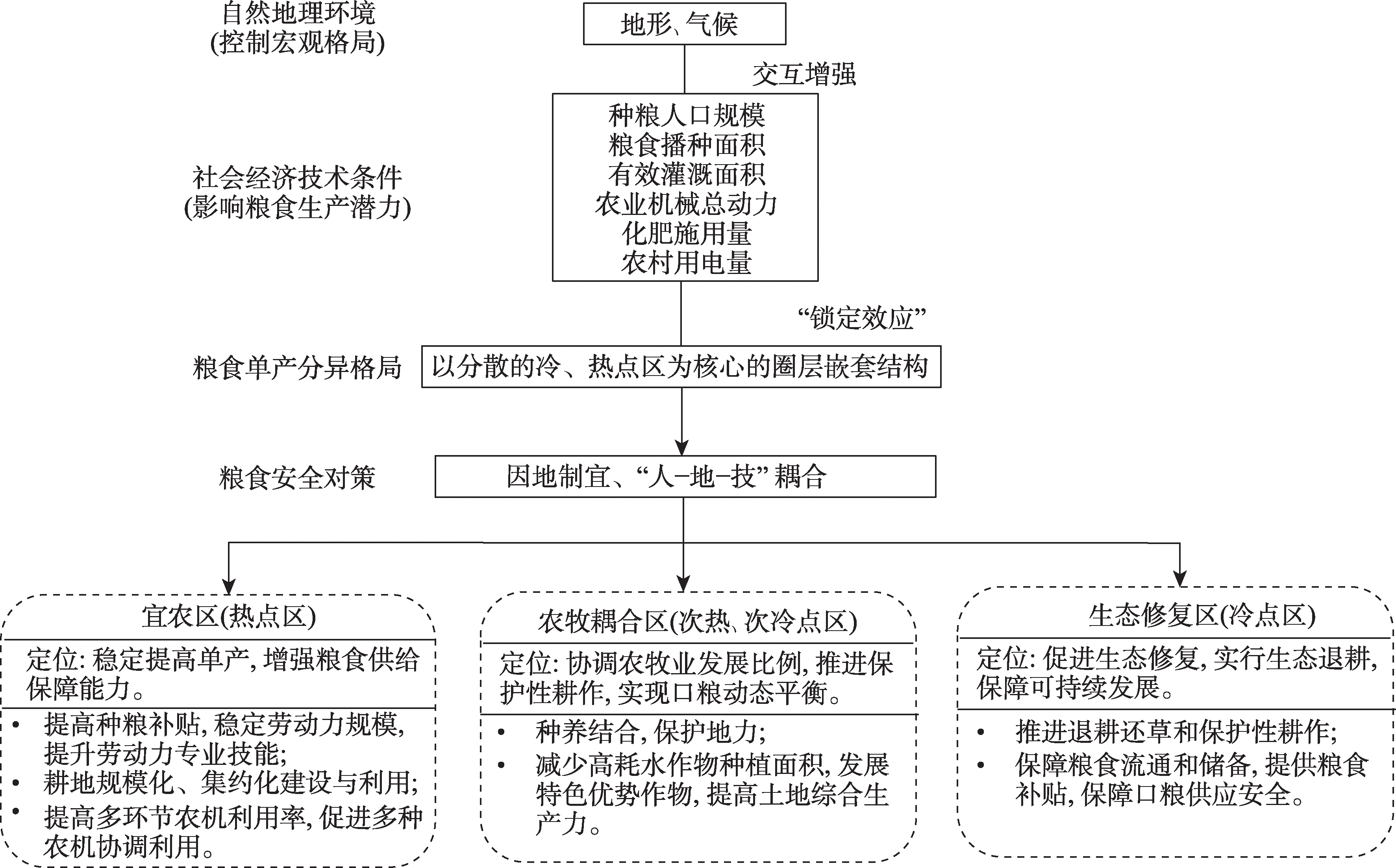
从中国北方农牧交错带粮食安全和粮食单产的重要性出发,利用空间自相关分析揭示带内粮食单产的空间分异及演化特征,作为划分农牧业发展地域的依据,进而利用地理探测器模型揭示控制单产分异的主导因子及其交互作用,藉此探讨提高带内粮食单产、保障粮食安全的对策。结果表明:(1) 2000—2020年带内粮食单产呈现相对稳定的集聚分布态势,自然环境分异大势是其基础性控制因素,社会生产条件及其耦合水平则强化了粮食单产的空间分异特征。(2) 单产热点区主要集中在带内东北部平原地区和西南部河湟谷地,冷点区分布在中部水土流失区和丘陵地区,次热和次冷点区则围绕热、冷点形成圈层结构;依据该格局可将热点区划分为宜农区,将次热和次冷区划分为农牧耦合区,将冷点区划分为生态修复区,以因地制宜地促进带内农牧业协调发展。(3) 2000—2020年带内粮食单产的增长模式从以劳动力为主导转变为以现代农业技术为主导,但出现了劳动力与耕地、现代农业技术之间过度解耦,以及各种现代农业技术之间的耦合性不足等问题,因而提出了以“人-地-技”耦合发展促进粮食单产健康增长、提高粮食安全保障能力的建议。
孔德明, 郝丽莎, 夏四友, 李红波. 粮食单产视角下中国北方农牧交错带粮食安全研究[J]. 干旱区地理, 2023, 46(5): 782-792.
KONG Deming, HAO Lisha, XIA Siyou, LI Hongbo. Food security in the argo-pastoral ecotone of northern China from the perspective of grain yield[J]. Arid Land Geography, 2023, 46(5): 782-792.

图1
研究思路分析 注:ESDA为探索性空间数据分析;GWR为地理加权回归。"
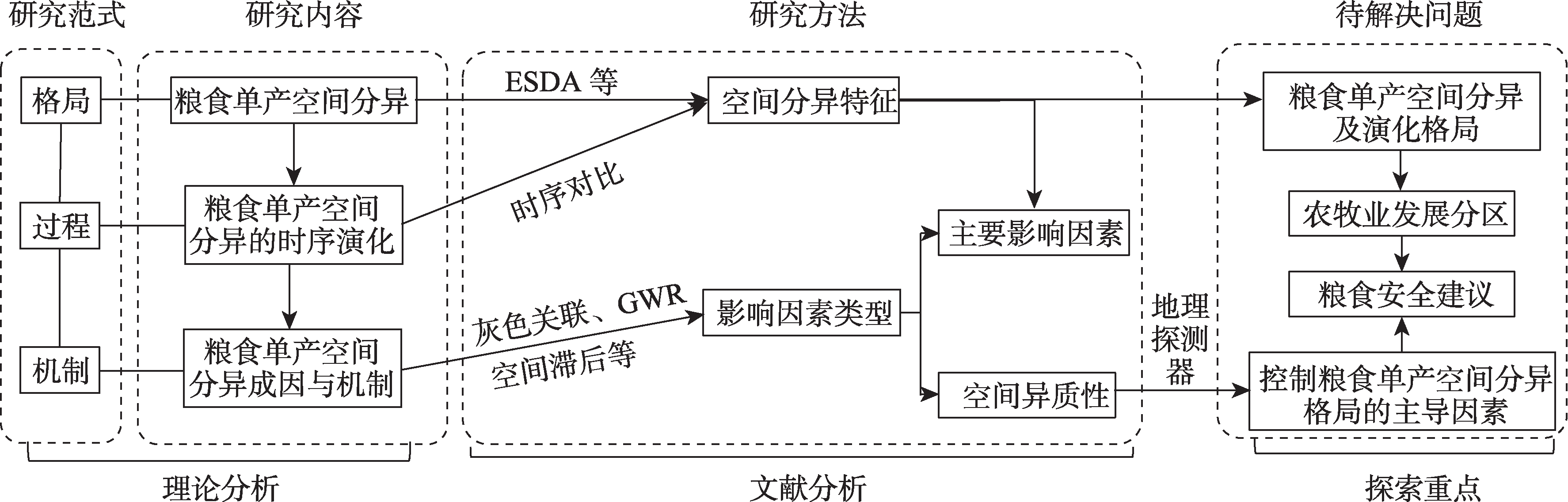

图2
北方农牧交错带示意图 注:该图基于国家测绘地理信息局标准地图服务网站下载的审图号为GS(2019)1822号的标准地图制作,底图边界无修改。下同。"
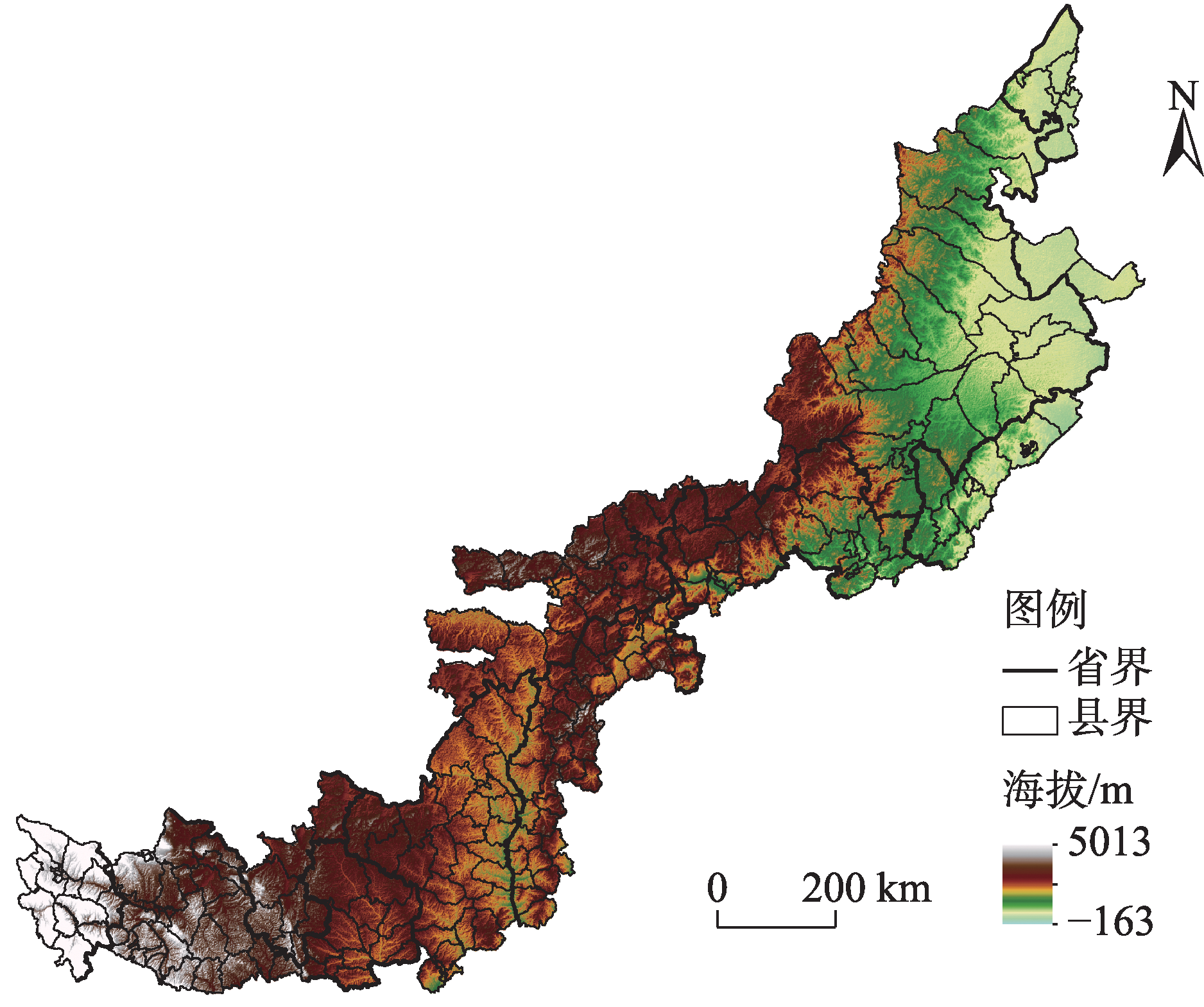
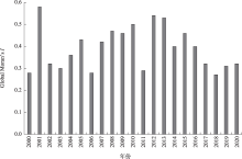
图3
2000—2020年中国北方农牧交错带粮食单产的全局莫兰指数(Global Moran’s I)时序演变"

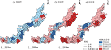
图4
2000—2020年中国北方农牧交错带粮食单产冷热点区域演化"

表1
中国北方农牧交错带粮食单产影响因素指标体系"
| 方面 | 指标 | 符号 | 指标内涵 |
|---|---|---|---|
| 社会生产条件 | 种粮人口规模/104人 | X1 | 从事粮食生产活动的劳动力保障,粮食生产活动得以进行的基本要素 |
| 粮食播种面积/hm2 | X2 | 反映了实际用于粮食生产的耕地面积,是粮食生产的基础载体,并且与农业现代化、规模化经营相关,能够影响农机、化肥、农药等的使用效率和规模经济效益 | |
| 有效灌溉面积/hm2 | X3 | 旱作农业生产条件的重要因素之一 | |
| 农业机械总动力/104 kW | X4 | 现代农业生产中影响粮食单产最重要的生产条件之一 | |
| 化肥施用量/t | X5 | 现代农业生产中影响粮食单产最重要的生产条件之一 | |
| 农村用电量/104 kW·h | X6 | 现代农业生产中影响粮食单产最重要的生产条件之一 | |
| 自然条件 | 坡度/(°) | X7 | 控制北方农牧交错带耕地分异大势的主要地形条件 |
| 海拔/m | X8 | 控制北方农牧交错带耕地分异大势的主要地形条件 | |
| 土壤肥力 | X9 | 耕地质量的主要指标,采用土壤肥力综合指数表示[ | |
| 年平均气温/℃ | X10 | 控制北方农牧交错带耕地分异大势的主要气候条件,主要影响粮食生产的水热条件 | |
| 年日照时数/h | X11 | 控制北方农牧交错带耕地分异大势的主要气候条件,主要影响粮食生产的水热条件 | |
| 年降水量/mm | X12 | 控制北方农牧交错带耕地分异大势的主要气候条件,主要影响粮食生产的水热条件 |
表2
中国北方农牧交错带粮食单产影响因素解释力探测"
| 指标 | 2000年 | 2020年 | |||
|---|---|---|---|---|---|
| q | P | q | P | ||
| X1 | 0.255** | 0.040 | 0.130** | 0.035 | |
| X2 | 0.109** | 0.020 | 0.090** | 0.042 | |
| X3 | 0.157*** | 0.010 | 0.173*** | 0.002 | |
| X4 | 0.110** | 0.026 | 0.210*** | 0.005 | |
| X5 | 0.151** | 0.046 | 0.245** | 0.033 | |
| X6 | 0.109** | 0.027 | 0.206*** | 0.004 | |
| X7 | 0.120** | 0.012 | 0.101** | 0.044 | |
| X8 | 0.096** | 0.022 | 0.226*** | 0.000 | |
| X9 | 0.085** | 0.035 | 0.088** | 0.039 | |
| X10 | 0.081** | 0.047 | 0.191*** | 0.003 | |
| X11 | 0.114*** | 0.003 | 0.178*** | 0.007 | |
| X12 | 0.144*** | 0.004 | 0.244*** | 0.000 | |
表3
各要素交互作用对粮食单产的解释力"
| 年份 | 指标 | X1 | X2 | X3 | X4 | X5 | X6 | X7 | X8 | X9 | X10 | X11 | X12 |
|---|---|---|---|---|---|---|---|---|---|---|---|---|---|
| 2000 | X1 | - | |||||||||||
| X2 | 0.534NE | - | |||||||||||
| X3 | 0.654NE | 0.429NE | - | ||||||||||
| X4 | 0.636NE | 0.396NE | 0.336NE | - | |||||||||
| X5 | 0.760NE | 0.545NE | 0.540NE | 0.525NE | - | ||||||||
| X6 | 0.616NE | 0.397NE | 0.346NE | 0.126BE | 0.518NE | - | |||||||
| X7 | 0.649NE | 0.396NE | 0.353NE | 0.315NE | 0.524NE | 0.315NE | - | ||||||
| X8 | 0.665NE | 0.377NE | 0.408NE | 0.293NE | 0.502NE | 0.297NE | 0.439NE | - | |||||
| X9 | 0.641NE | 0.331NE | 0.336NE | 0.338NE | 0.518NE | 0.333NE | 0.410NE | 0.295NE | - | ||||
| X10 | 0.625NE | 0.326NE | 0.333NE | 0.340NE | 0.506NE | 0.334NE | 0.396NE | 0.287NE | 0.106BE | - | |||
| X11 | 0.560NE | 0.340NE | 0.401NE | 0.367NE | 0.633NE | 0.368NE | 0.477NE | 0.395NE | 0.514NE | 0.516NE | - | ||
| X12 | 0.566NE | 0.372NE | 0.431NE | 0.360NE | 0.639NE | 0.362NE | 0.468NE | 0.403NE | 0.353NE | 0.350NE | 0.372NE | - | |
| 年份 | X1 | X2 | X3 | X4 | X5 | X6 | X7 | X8 | X9 | X10 | X11 | X12 | |
| 2020 | X1 | - | |||||||||||
| X2 | 0.377NE | - | |||||||||||
| X3 | 0.392NE | 0.469NE | - | ||||||||||
| X4 | 0.479NE | 0.448NE | 0.396NE | - | |||||||||
| X5 | 0.554NE | 0.602NE | 0.474NE | 0.413BE | - | ||||||||
| X6 | 0.475NE | 0.444NE | 0.389NE | 0.215BE | 0.407BE | - | |||||||
| X7 | 0.530NE | 0.457NE | 0.412NE | 0.423NE | 0.569NE | 0.421NE | - | ||||||
| X8 | 0.531NE | 0.431NE | 0.502NE | 0.517NE | 0.634NE | 0.514NE | 0.424NE | - | |||||
| X9 | 0.396NE | 0.114BE | 0.468NE | 0.476NE | 0.608NE | 0.474NE | 0.469NE | 0.432NE | - | ||||
| X10 | 0.648NE | 0.477NE | 0.645NE | 0.588NE | 0.672NE | 0.594NE | 0.665NE | 0.581NE | 0.489NE | - | |||
| X11 | 0.641NE | 0.453NE | 0.649NE | 0.580NE | 0.668NE | 0.586NE | 0.664NE | 0.578NE | 0.441NE | 0.203BE | - | ||
| X12 | 0.631NE | 0.548NE | 0.611NE | 0.635NE | 0.684NE | 0.645NE | 0.725NE | 0.635NE | 0.560NE | 0.816NE | 0.815NE | - |
表4
中国北方农牧交错带生产功能分区"
| 类型 | 省(区) | 县域 |
|---|---|---|
| 宜农区(热点区) | 内蒙古自治区 | 科尔沁左翼中旗、开鲁县、松山区、科尔沁区、科尔沁左翼后旗、宁城县、喀喇沁旗 |
| 辽宁省 | 建平县、凌源市、龙城区 | |
| 河北省 | 平泉市、承德县、隆化县 | |
| 陕西省 | 甘泉县、富县、黄陵县、洛川县、黄龙县、宜君县、印台区、王益区 | |
| 甘肃省 | 永登县、红古区、皋兰县、西固区、城关区、七里河区、永靖县、积石山县、临夏县、临夏市、临洮县、东乡族自治县、和政县、广河县、康乐县、渭源县 | |
| 青海省 | 民和县、循化县、同仁县、乐都区、互助县、大通县、湟中区、城西区、城北区、城中区、城东区、平安区、化隆县、尖扎县、贵德县 | |
| 农牧耦合区(次热、次冷点区) | 黑龙江省 | 龙江县、甘南县、泰来县 |
| 吉林省 | 通榆县、长岭县 | |
| 辽宁省 | 彰武县、朝阳县、北票市、阜新蒙古族自治县、建昌县等 | |
| 河北省 | 赤城县、滦平县、怀安县、万全区等 | |
| 山西省 | 灵丘县、应县、右玉县、山阴县等 | |
| 陕西省 | 定边县、靖边县、安塞区、延川县等 | |
| 内蒙古自治区 | 达拉特旗、清水河县、多伦县、林西县等 | |
| 宁夏回族自治区 | 同心县、隆德县、盐池县、原州区等 | |
| 甘肃省 | 通渭县、安定区、环县、庆城县等 | |
| 生态修复区(冷点区) | 内蒙古自治区 | 太仆寺旗、化德县、商都县、察哈尔右翼后旗、察哈尔右翼中旗、察哈尔右翼前旗、集宁区、卓资县、兴和县、凉城县、赛罕区、和林格尔县 |
| 河北省 | 尚义县 | |
| 山西省 | 五寨县、保德县、岢岚县、兴县、岚县、临县、方山县、娄烦县、古交市、离石区、柳林县、中阳县、石楼县、汾西县 | |
| 陕西省 | 吴堡县、绥德县、清涧县 |
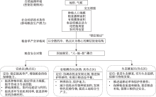
图5
中国北方农牧交错到粮食安全保障机制示意图"
| [1] | 纪龙, 徐春春, 陈中督, 等. 中国粮食生产波动: 特征、成因及启示[J]. 中国农业资源与区划, 2020, 41(3): 46-52. |
| [Ji Long, Xu Chunchun, Chen Zhongdu, et al. The fluctuation of grain production in China: Characteristics, causes and implications[J]. Chinese Journal of Agricultural Resources and Regional Planning, 2020, 41(3): 46-52. ] | |
| [2] | 李先德, 孙致陆, 赵玉菡. 全球粮食安全及其治理: 发展进程、现实挑战和转型策略[J]. 中国农村经济, 2022(6): 2-22. |
| [Li Xiande, Sun Zhilu, Zhao Yuhan. Global food security and its governance: Development process, practical challenges and transformation strategies[J]. Chinese Rural Economy, 2022(6): 2-22. ] | |
| [3] | 丁存振, 徐宣国. 国际粮食供应链安全风险与应对研究[J]. 经济学家, 2022(6): 109-118. |
| [Ding Cunzhen, Xu Xuanguo. Research on security risks of international food supply chain and countermeasures[J]. Economist, 2022(6): 109-118. ] | |
| [4] | 赵磊. 全球粮食安全与中国特色粮食安全治理[J]. 当代中国与世界, 2022(2): 59- 67, 127-128. |
| [Zhao Lei. Global food security and food security governance with Chinese characteristics[J]. Contemporary China and World, 2022(2): 59- 67, 127-128. ] | |
| [5] |
成升魁, 李云云, 刘晓洁, 等. 关于新时代我国粮食安全观的思考[J]. 自然资源学报, 2018, 33(6): 911-926.
doi: 10.31497/zrzyxb.20170527 |
|
[Cheng Shengkui, Li Yunyun, Liu Xiaojie, et al. Thoughts on food security in China in the new period[J]. Journal of Natural Resources, 2018, 33(6): 911-926. ]
doi: 10.31497/zrzyxb.20170527 |
|
| [6] | 高树琴, 段瑞, 王竑晟, 等. 北方农牧交错带在保障国家大粮食安全中发挥重要作用[J]. 中国科学院院刊, 2021, 36(6): 643-651. |
| [Gao Shuqin, Duan Rui, Wang Hongsheng, et al. Farming-pastoral ecotone of northern China plays important role in ensuring national food security[J]. Bulletin of Chinese Academy of Sciences, 2021, 36(6): 643-651. ] | |
| [7] | 张志新, 王迪, 唐海云. 中国粮食安全保障程度: 基于粮食消费结构变化的分析[J]. 消费经济, 2022, 38(5): 38-49. |
| [Zhang Zhixin, Wang Di, Tang Haiyun. China’s grain security guarantee: An analysis based on the change of grain consumption structure[J]. Consumer Economics, 2022, 38(5): 38-49. ] | |
| [8] | 陶泽涪, 王世清, 孙丕苓, 等. 中国北方农牧交错带耕地时空分异及驱动因素[J]. 干旱区地理, 2022, 45(1): 153-163. |
| [Tao Zefu, Wang Shiqing, Sun Piling, et al. Spatio-temporal differentiation and driving factors of cropland in the agro-pastoral ecotone of northern China[J]. Arid Land Geography, 2022, 45(1): 153-163. ] | |
| [9] | 陈海, 康慕谊, 曹明明. 北方农牧交错带农林牧业生产结构类型空间分异特征研究[J]. 水土保持通报, 2007, 27(2): 46-49. |
| [Chen Hai, Kang Muyi, Cao Mingming. Spatial differentiation pattern of production structure in the farming-pastoral crisscross zone of north China[J]. Bulletin of Soil and Water Conservation, 2007, 27(2): 46-49. ] | |
| [10] | 胡兵辉, 廖允成, 王克勤, 等. 北方农牧交错带县域典型农业生态系统结构的对比演变[J]. 水土保持研究, 2011, 18(2): 35-39, 43. |
| [Hu Binghui, Liao Yuncheng, Wang Keqin, et al. The comparison and evolvement of agroecosystem structure in representative counties of the farming-pastoral ecotones in north China[J]. Research of Soil and Water Conservation, 2011, 18(2): 35-39, 43. ] | |
| [11] | 周立华, 马永欢, 马绍休. 中国北方农牧交错带风水蚀复合区的粮食与退耕还林(草)问题[J]. 中国沙漠, 2007, 27(4): 552-557. |
| [Zhou Lihua, Ma Yonghuan, Ma Shaoxiu. Food supply and grain for green proiect in the water-wind erosion compound areas of farming and grazing interlaced zone in northern China[J]. Journal of Desert Research, 2007, 27(4): 552-557. ] | |
| [12] | 李玉红. 内蒙古粮食生产与生态安全屏障建设研究[J]. 生态经济, 2017, 33(3): 115-119. |
| [Li Yuhong. On grain production and ecological security barrier construction in Inner Mongolia[J]. Ecological Economy, 2017, 33(3): 115-119. ] | |
| [13] | 安萍莉, 潘志华, 郑大玮. 北方农牧交错带土地利用结构重建研究——以武川县为例[J]. 资源科学, 2002, 24(1): 35-39. |
| [An Pingli, Pan Zhihua, Zheng Dawei. Reconstruction land use structure in northern ecotone: The case of Wuchuan County[J]. Resources Science, 2002, 24(1): 35-39. ] | |
| [14] |
杨骞, 司祥慧, 王珏. 减排增汇目标下中国粮食生产效率的测度及分布动态演进[J]. 自然资源学报, 2022, 37(3): 600-615.
doi: 10.31497/zrzyxb.20220304 |
|
[Yang Qian, Si Xianghui, Wang Jue. The measurement and its distribution dynamic evolution of grain production efficiency in China under the goal of reducing pollution emissions and increasing carbon sink[J]. Journal of Natural Resources, 2022, 37(3): 600-615. ]
doi: 10.31497/zrzyxb.20220304 |
|
| [15] | 柏林川, 武兰芳, 宋小青. 1995—2010年山东省粮食单产变化空间分异及均衡增产潜力[J]. 地理科学进展, 2013, 32(8): 1257-1265. |
| [Bai Linchuan, Wu Lanfang, Song Xiaoqing. Spatial difference of grain yield changes during 1995—2010 and balanced potential output to increase in Shandong Province[J]. Progress in Geography, 2013, 32(8): 1257-1265. ] | |
| [16] | 刘同山. 新时代保障国家粮食安全的内涵、挑战与建议[J]. 中州学刊, 2022(2): 20-27. |
| [Liu Tongshan. Connotations, challenges, and policy recommendations for ensuring national grain security in the new era[J]. Academic Journal of Zhongzhou, 2022(2): 20-27. ] | |
| [17] | 张利国, 鲍丙飞, 董亮. 鄱阳湖生态经济区粮食单产时空格局演变及驱动因素探究[J]. 经济地理, 2018, 38(2): 154-161. |
| [Zhang Liguo, Bao Bingfei, Dong Liang. Spatial and temporal pattern evolution of grain yield and spatial heterogeneity of driving factors in Poyang Lake eco-economic zone[J]. Economic Geography, 2018, 38(2): 154-161. ] | |
| [18] |
邱孟龙, 曹小曙, 周建, 等. 基于GWR模型的渭北黄土旱塬粮食单产空间分异及其影响因子分析——以陕西彬县为例[J]. 中国农业科学, 2019, 52(2): 273-284.
doi: 10.3864/j.issn.0578-1752.2019.02.007 |
|
[Qiu Menglong, Cao Xiaoshu, Zhou Jian, et al. Spatial differentiation and impact factors of grain yield per hectare in Weibei Plateau based on GWR model: A case study of Binxian County, Shannxi[J]. Scientia Agricultura Sinica, 2019, 52(2): 273-284. ]
doi: 10.3864/j.issn.0578-1752.2019.02.007 |
|
| [19] |
程叶青. 东北地区粮食单产空间格局变化及其动因分析[J]. 自然资源学报, 2009, 24(9): 1541-1549.
doi: 10.11849/zrzyxb.2009.09.004 |
|
[Cheng Yeqing. Spatial pattern change and its driving factors of grain per unit area yield in northeast China[J]. Journal of Natural Resources, 2009, 24(9): 1541-1549. ]
doi: 10.11849/zrzyxb.2009.09.004 |
|
| [20] | 刘玉, 唐秀美, 潘瑜春, 等. 黄淮海地区县域粮食单产的空间溢出效应及影响因素分析[J]. 农业工程学报, 2016, 32(9): 299-307. |
| [Liu Yu, Tang Xiumei, Pan Yuchun, et al. Analysis on spatial spillover effect and influence factors of grain yield per hectare at county level in Huang-Huai-Hai region[J]. Transactions of the Chinese Society of Agricultural Engineering, 2016, 32(9): 299-307. ] | |
| [21] | 夏四友, 赵媛, 许昕, 等. 江苏省粮食生产时空格局及其驱动因素[J]. 经济地理, 2018, 38(12): 166-175. |
| [Xia Siyou, Zhao Yuan, Xu Xin, et al. Spatiotemporal pattern and driving factors of grain production in Jiangsu Province[J]. Economic Geography, 2018, 38(12): 166-175. ] | |
| [22] |
殷培红, 方修琦, 张学珍, 等. 中国粮食单产对气候变化的敏感性评价[J]. 地理学报, 2010, 65(5): 515-524.
doi: 10.11821/xb201005001 |
|
[Yin Peihong, Fang Xiuqi, Zhang Xuezhen, et al. Identification of the susceptible regions to climate change impact on grain yield per unit area in China[J]. Acta Geographica Sinica, 2010, 65(5): 515-524. ]
doi: 10.11821/xb201005001 |
|
| [23] |
李梦华, 韩颖娟, 赵慧, 等. 基于地理探测器的宁夏植被覆盖度时空变化特征及其驱动因子分析[J]. 生态环境学报, 2022, 31(7): 1317-1325.
doi: 10.16258/j.cnki.1674-5906.2022.07.004 |
|
[Li Menghua, Han Yingjuan, Zhao Hui, et al. Analysis on spatial-temporal variation characteristics and driving factors of fractional vegetation cover in Ningxia based on geographical detector[J]. Ecology and Environmental Sciences, 2022, 31(7): 1317-1325. ]
doi: 10.16258/j.cnki.1674-5906.2022.07.004 |
|
| [24] |
李云涛, 陶犁. 基于地理探测器的云南省边境州市旅游发展水平空间分异及影响因素分析[J]. 世界地理研究, 2022, 31(3): 624-636.
doi: 10.3969/j.issn.1004-9479.2022.03.2020513 |
|
[Li Yuntao, Tao Li. An analysis of spatial differentiation of tourism development level in border cities of Yunnan Province and influencing factors based on geo-detector[J]. World Regional Studies, 2022, 31(3): 624-636. ]
doi: 10.3969/j.issn.1004-9479.2022.03.2020513 |
|
| [25] |
史文娇, 刘奕婷, 石晓丽. 气候变化对北方农牧交错带界线变迁影响的定量探测方法研究[J]. 地理学报, 2017, 72(3): 407-419.
doi: 10.11821/dlxb201703004 |
|
[Shi Wenjiao, Liu Yiting, Shi Xiaoli. Quantitative methods for detecting the impacts of climate change on the fluctuation of farming-pastoral ecotone boundaries in northern China[J]. Acta Geographica Sinica, 2017, 72(3): 407-419. ]
doi: 10.11821/dlxb201703004 |
|
| [26] |
任强, 何春阳, 黄庆旭, 等. 中国北方农牧交错带贫困动态——基于贫困距离指数的分析[J]. 资源科学, 2018, 40(2): 404-416.
doi: 10.18402/resci.2018.02.16 |
|
[Ren Qiang, He Chunyang, Huang Qingxu, et al. The poverty dynamics in the agro-pastoral transitional zone in northern China: A multi-scale perspective based on the poverty gap index[J]. Resources Science, 2018, 40(2): 404-416. ]
doi: 10.18402/resci.2018.02.16 |
|
| [27] | 邓晓倩, 马素娟, 曹晓萍, 等. 青海省互助县10年耕地土壤养分状况、变化趋势及肥力评价[J]. 水土保持研究, 2022, 29(6): 112-120. |
| [Deng Xiaoqian, Ma Sujuan, Cao Xiaoping, et al. Evaluation of the cultivated land fertility and trend of soil nutrient status of Huzhu County in Qinghai Province in the past 10 years[J]. Research of Soil and Water Conservation, 2022, 29(6): 112-120. ] | |
| [28] | 李颉, 郑步云, 王劲峰. 2008—2018年中国手足口病时空分异特征[J]. 地球信息科学学, 2021, 23(3): 419-430. |
| [Li Jie, Zheng Buyun, Wang Jinfeng. Spatial-temporal heterogeneity of hand, foot and mouth disease in China from 2008 to 2018[J]. Journal of Geo-information Science, 2021, 23(3): 419-430. ] | |
| [29] |
王劲峰, 徐成东. 地理探测器: 原理与展望[J]. 地理学报, 2017, 72(1): 116-134.
doi: 10.11821/dlxb201701010 |
|
[Wang Jinfeng, Xu Chengdong. Geodetector: Principle and prospective[J]. Acta Geographica Sinica, 2017, 72(1): 116-134. ]
doi: 10.11821/dlxb201701010 |
|
| [30] | 王俊帝, 刘志强, 刘俪胤, 等. 基于地理探测器的中国典型样带建成区绿地率空间分异的影响机理研究[J]. 生态经济, 2020, 36(10): 104-111. |
| [Wang Jundi, Liu Zhiqiang, Liu Liyin, et al. Study on the influencing mechanism of spatial differentiation of green rate of built district of typical transects in China based on geodetector[J]. Ecological Economy, 2020, 36(10): 104-111. ] | |
| [31] | 闫旭东, 吴晓光, 张宏飞, 等. 基于粮食安全和生态安全视角的区域粮食生产布局分区——以内蒙古自治区为例[J]. 干旱区资源与环境, 2017, 31(9): 156-162. |
| [Yan Xudong, Wu Xiaoguang, Zhang Hongfei, et al. Regional food production layout based on food security and ecological: The Inner Mongolia Autonomous Region[J]. Journal of Arid Land Resources and Environment, 2017, 31(9): 156-162. ] | |
| [32] | 温静, 张超, 张丽君, 等. 气候变化下中国粮食生产时空演变及影响因素[J]. 河南大学学报(自然科学版), 2020, 50(6): 652-665. |
| [Wen Jing, Zhang Chao, Zhang Lijun, et al. Spatiotemporal evolution and influencing factors of Chinese grain production under climate change[J]. Journal of Henan University (Natural Science Edition), 2020, 50(6): 652-665. ] | |
| [33] | 汤瑛芳, 李红霞, 刘锦晖, 等. 甘肃省粮食生产形势及新时期粮食安全对策研究[J]. 甘肃农业科技, 2021, 52(8): 63-71. |
| [Tang Yingfang, Li Hongxia, Liu Jinhui, et al. Situation of grain production in Gansu Province and countermeasures for grain security in new period[J]. Gansu Agricultural Science and Technology, 2021, 52(8): 63-71. ] | |
| [34] | 文琦, 刘彦随. 北方干旱化对水土资源与粮食安全的影响及适应——以陕北地区为例[J]. 干旱区资源与环境, 2008, 22(7): 7-11. |
| [Wen Qi, Liu Yansui. The response of water, land and food security towards the aridification and the adaptive measures: Case study of northern Shaanxi Province[J]. Journal of Arid Land Resources and Environment, 2008, 22(7): 7-11. ] |
| [1] | 程云洁, 杨淋杰. 中国旅游双循环市场效率空间演进及驱动因素异质性研究[J]. 干旱区地理, 2024, 47(9): 1606-1616. |
| [2] | 张璐, 孙美平, 闫欣, 王伟生, 范蕊谊. 基于多源数据的昆仑山北坡地表太阳辐射调查评估[J]. 干旱区地理, 2024, 47(8): 1304-1313. |
| [3] | 朱磊, 李燕楠, 徐佳慧, 胡静, 朱芳, 梁茫茫. 中国冰雪旅游地空间分布格局及成因[J]. 干旱区地理, 2024, 47(8): 1399-1410. |
| [4] | 陈聪, 唐英, 史承勇, 杜怡帆, 赵丽娜, 姜旭妍. 黄河流域遗产资源空间分布与区域协同保护[J]. 干旱区地理, 2024, 47(7): 1220-1232. |
| [5] | 张晓东, 武丹, 王莹, 赵银鑫, 马瑜, 马玉学, 倪海玲. 耦合InVEST与Geodetector模型的银川市生境质量时空演变特征及影响因子研究[J]. 干旱区地理, 2024, 47(7): 1242-1251. |
| [6] | 林秋平, 李松芮, 杨上广, 王云云. 乌鲁木齐市物流企业区位时空演化、影响因素和发展策略研究[J]. 干旱区地理, 2024, 47(7): 1252-1262. |
| [7] | 卢泉, 高花彦, 王鹏鹏, 冯啸林, 杨艳霞. 塔里木河流域水-耕地-粮棉系统耦合关系及影响因素分析[J]. 干旱区地理, 2024, 47(5): 820-829. |
| [8] | 赵雪纯, 菊春燕. 公园绿地与城市功能空间耦合协调关系及影响因素分析——以乌鲁木齐市为例[J]. 干旱区地理, 2024, 47(5): 898-908. |
| [9] | 卢冬燕, 朱秀芳, 唐明秀, 郭春华, 刘婷婷. 不同温升情景下中国旱灾风险变化评估[J]. 干旱区地理, 2024, 47(3): 369-379. |
| [10] | 张明斗, 任衍婷, 周亮. 黄河流域城市生态韧性时空演变特征及影响因素分析[J]. 干旱区地理, 2024, 47(3): 445-454. |
| [11] | 唐宇, 薛东前, 宋永永, 叶昊, 王莎. 中国夜间文旅消费集聚区空间格局及影响机理[J]. 干旱区地理, 2024, 47(3): 485-495. |
| [12] | 李俊佳, 赵美风. 中国民族地区高质量发展空间演变及其影响机理[J]. 干旱区地理, 2024, 47(3): 496-505. |
| [13] | 陈繁繁, 白永平, 梁建设, 张春悦, 赵越, 龚享林. 兰州市蔬菜市场的空间分布特征及影响因素研究[J]. 干旱区地理, 2024, 47(2): 293-306. |
| [14] | 慕石雷, 杨玉欢, 乌日陶克套胡. 国家沙漠(石漠)公园空间分异格局与影响因素[J]. 干旱区地理, 2024, 47(2): 356-368. |
| [15] | 王瑞, 郭荔, 戴俊骋, 程哲. 中国包容性旅游发展评估及空间格局研究——基于287个城市面板数据[J]. 干旱区地理, 2024, 47(1): 127-136. |
| Viewed | ||||||||||||||||||||||||||||||||||||||||||||||||||
|
Full text 2018
|
|
|||||||||||||||||||||||||||||||||||||||||||||||||
|
Abstract 363
|
|
|||||||||||||||||||||||||||||||||||||||||||||||||
Cited |
|
|||||||||||||||||||||||||||||||||||||||||||||||||
| Shared | ||||||||||||||||||||||||||||||||||||||||||||||||||
|
||