- 2025年7月16日 星期三
干旱区地理 ›› 2022, Vol. 45 ›› Issue (6): 1824-1835.doi: 10.12118/j.issn.1000-6060.2022.082 cstr: 32274.14.ALG2022082
张久丹1,2,3( ),李均力1,3(),包安明1,3,白洁1,3,刘铁1,3,黄粤1,3
收稿日期:2022-03-04
修回日期:2022-04-01
出版日期:2022-11-25
发布日期:2023-02-01
作者简介:张久丹(1995-),女,博士研究生,主要从事干旱区湿地遥感等方面的研究. E-mail: 基金资助:
ZHANG Jiudan1,2,3(),LI Junli1,3(),BAO Anming1,3,BAI Jie1,3,LIU Tie1,3,HUANG Yue1,3
Received:2022-03-04
Revised:2022-04-01
Published:2022-11-25
Online:2023-02-01
摘要:
生态输水是塔里木河流域退化胡杨林生态恢复的主要措施,及时监测和准确评估其恢复成效是优化输水策略、完善胡杨林修复体系的关键。以2013年以来8个胡杨林区为研究对象,基于中高分辨率遥感数据监测不同胡杨林区生态输水前后植被面积、长势及植被覆盖度的时序变化,探讨胡杨林恢复与生态输水的关系。结果表明:(1) 2016年以来整个流域累计漫溢水面为2172.96 km2,占林区总面积的4.39%,主要分布在输水通道两侧及末端10 km范围内。(2) 输水前后林区植被整体呈现由退化到恢复的转变,林区生态恢复水平与年最大漫溢面积显著正相关。(3) 生态恢复成效评估表明,生态恢复最显著的区域是塔里木河中上游和叶尔羌河下游的夏马勒林场,但整个流域远离输水通道的胡杨林仍有退化趋势。合理规划输水通道建设,扩大胡杨林区的受水范围是退化胡杨林生态恢复的关键。
张久丹, 李均力, 包安明, 白洁, 刘铁, 黄粤. 2013—2020年塔里木河流域胡杨林生态恢复成效评估[J]. 干旱区地理, 2022, 45(6): 1824-1835.
ZHANG Jiudan, LI Junli, BAO Anming, BAI Jie, LIU Tie, HUANG Yue. Effectiveness assessment of ecological restoration of Populus euphratica forest in the Tarim River Basin during 2013—2020[J]. Arid Land Geography, 2022, 45(6): 1824-1835.
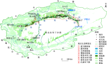
图1
研究区概况图"

表1
遥感数据时相选择"
| 林区 | 输水实施时间 | 监测时间 | |
|---|---|---|---|
| 水体 | 植被 | ||
| 夏马勒林场 | 8月下旬至10月下旬 | 8—11月 | 6月或7月 |
| 夏河林场 | 8月下旬至10月下旬 | 8—11月 | 6月或 7月 |
| 艾西曼湿地 | 8月下旬至9月下旬 | 8—10月 | 8月上旬 |
| 博斯坦林场 | 8月上旬至9月下旬 | 8—10月 | 6月或7月 |
| 塔里木河上游 | 8月下旬至10月下旬 | 8—11月 | 6月或7月 |
| 塔里木河中游 | 8月下旬至10月下旬 | 8—11月 | 6月或7月 |
| 塔里木河下游 | 8月下旬至10月下旬 | 8—11月 | 7月或8月 |
| 孔雀河下游 | 4月和11月 | 4月和11月 | 7月或8月 |
表2
塔里木河流域植被长势恢复综合评估指标体系"
| 序号 | 指标 | 序号 | 指标 |
|---|---|---|---|
| X1 | 植被面积年均变化率 | X6 | NDVI增量>0的面积占比 |
| X2 | NDVI年均变化率 | X7 | NDVI>0.3的面积变化量 |
| X3 | FVC年均变化率 | X8 | NDVI>0.3的面积变化量占比 |
| X4 | 植被面积增量占比 | X9 | 0.1<NDVI<0.3的面积变化量 |
| X5 | NDVI增量>0的面积 | X10 | 0.1<NDVI<0.3的面积变化量占比 |
表3
各区域植被恢复水平划分"
| 植被恢复水平 | 综合得分 | 评级 |
|---|---|---|
| 极显著恢复 | [1.5, 2.0] | Ⅰ |
| 显著恢复 | [1.0, 1.5) | Ⅱ |
| 中等恢复 | [0.5, 1.0) | Ⅲ |
| 轻度恢复 | [0.1, 0.5) | Ⅳ |
| 无恢复 | [0.0, 0.1) | Ⅴ |

图2
2013—2020年塔里木河流域不同林区植被面积变化"
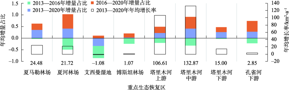
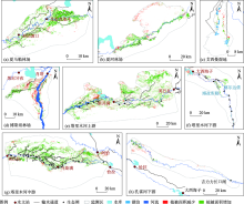
图3
2013—2020年塔里木河流域不同林区植被恢复空间分布"


图4
2013—2020年塔里木河流域不同林区NDVI变化 注:NDVI为归一化植被指数。下同。"
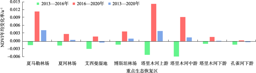

图5
2013—2020年塔里木河流域不同林区FVC变化 注:FVC为植被覆盖度。下同。"
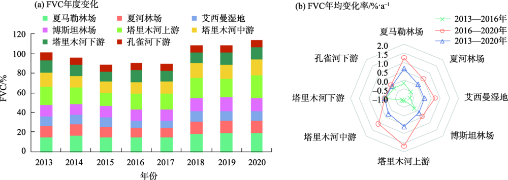
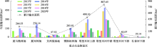
图6
2013—2020年塔里木河流域不同林区输水漫溢面积变化"

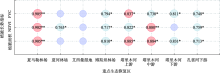
图7
植被长势指标年变化量与年输水面积的关系 注:*表示P<0.05;**表示P<0.01。"

表4
塔里木河流域不同林区植被恢复综合得分及分级"
| 评级 | 夏马勒林场 | 夏河林场 | 艾西曼湿地 | 博斯坦林场 | 塔里木河上游 | 塔里木河中游 | 塔里木河下游 | 孔雀河下游 |
|---|---|---|---|---|---|---|---|---|
| 综合得分 | 0.69 | 0.16 | 0.42 | 0.49 | 1.61 | 1.67 | 0.74 | 0.31 |
| 恢复水平 | 中等 | 轻度 | 轻度 | 轻度 | 极显著 | 极显著 | 中等 | 轻度 |
| 级别 | Ⅲ | Ⅳ | Ⅳ | Ⅳ | Ⅰ | Ⅰ | Ⅲ | Ⅳ |
| [1] | 陈亚宁, 李卫红, 陈亚鹏, 等. 新疆塔里木河下游断流河道输水与生态恢复[J]. 生态学报, 2007, 27(2): 538-545. |
| [Chen Yaning, Li Weihong, Chen Yapeng, et al. Water conveyance in dried-up riverway and ecological restoration in the lower reaches of Tarim River, China[J]. Acta Ecologica Sinica, 2007, 27(2): 538-545.] | |
| [2] | Liu J Z, Chen Y N, Chen Y J, et al. Degradation of Populus euphratica community in the lower reaches of the Tarim River, Xinjiang, China[J]. Journal of Environmental Sciences, 2005, 17(5): 740-747. |
| [3] | 白元, 徐海量, 刘新华, 等. 塔里木河干流荒漠河岸林的空间分布与生态保护[J]. 自然资源学报, 2013, 28(5): 776-785. |
| [Bai Yuan, Xu Hailiang, Liu Xinhua, et al. Spatial distribution characteristics and ecological protection of the desert riparian forest in the mainstream of the Tarim River[J]. Journal of Natural Resources, 2013, 28(5): 776-785.] | |
| [4] |
Xue L Q, Wang J, Zhang L C, et al. Spatiotemporal analysis of ecological vulnerability and management in the Tarim River Basin, China[J]. Science of the Total Environment, 2018, 649: 876-888.
doi: 10.1016/j.scitotenv.2018.08.321 |
| [5] |
Bao A M, Huang Y, Ma Y G, et al. Assessing the effect of EWDP on vegetation restoration by remote sensing in the lower reaches of Tarim River[J]. Ecological Indicators, 2017, 74: 261-275.
doi: 10.1016/j.ecolind.2016.11.007 |
| [6] |
Aishan T, Betz F, Halik Ü, et al. Biomass carbon sequestration potential by riparian forest in the Tarim River Watershed, northwest China: Implication for the mitigation of climate change impact[J]. Forests, 2018, 9(4): 196, doi: 10.3390/f9040196.
doi: 10.3390/f9040196 |
| [7] | 杨玉海, 朱成刚, 汪洋, 等. 塔里木河下游生态输水对胡杨林生态系统碳循环的影响[J]. 干旱区地理, 2021, 44(3): 637-642. |
| [Yang Yuhai, Zhu Chenggang, Wang Yang, et al. Effects of ecological water conveyance on carbon cycle of Populus euphratica forest ecosystem in the lower reaches of Tarim River[J]. Arid Land Geography, 2021, 44(3): 637-642.] | |
| [8] |
Liao S M, Xue L Q, Dong Z C, et al. Cumulative ecohydrological response to hydrological processes in arid basins[J]. Ecological Indicators, 2020, 111(24): 106005, doi: 10.1016/j.ecolind.2019.106005.
doi: 10.1016/j.ecolind.2019.106005 |
| [9] |
Mamat Z, Halik U, Aishan T, et al. Ecological effect of the riparian ecosystem in the lower reaches of the Tarim River in northwest China[J]. PloS One, 2019, 14(1): e0208462, doi: 10.1371/journal.pone.0208462.
doi: 10.1371/journal.pone.0208462 |
| [10] |
蔚亮, 李均力, 包安明, 等. 塔里木河下游湿地面积时序变化及对生态输水的响应[J]. 植物生态学报, 2020, 44(6): 616-627.
doi: 10.17521/cjpe.2019.0267 |
|
[Yu Liang, Li Junli, Bao Anming, et al. Temporal areal changes of wetlands in the lower reaches of the Tarim River and their responses to ecological water conveyance[J]. Chinese Journal of Plant Ecology, 2020, 44(6): 616-627.]
doi: 10.17521/cjpe.2019.0267 |
|
| [11] | 高生峰, 叶茂, 赵新风, 等. 极端干旱区淹灌对胡杨(Populus euphratica)长势的影响——以叶尔羌河中、下游为例[J]. 灌溉排水学报, 2018, 37(增刊2): 29-35. |
| [Gao Shengfeng, Ye Mao, Zhao Xinfeng, et al. Analysis on the growth trend of Populus euphratica on Yarkant River after flood irrigation[J]. Journal of Irrigation and Drainage, 2018, 37(Suppl. 2): 29-35.] | |
| [12] | 李金, 徐海量, 王勇辉, 等. 叶尔羌河下游河岸胡杨种群长势与植物多样性对淹灌的响应评估[J]. 生态与农村环境学报, 2019, 35(7): 859-866. |
| [Li Jin, Xu Hailiang, Wang Yonghui, et al. Evaluation on response of Populus euphratica population growth and plant diversity to flooding irrigation in lower reaches of Yarkant River Basin[J]. Journal of Ecology and Rural Environment, 2019, 35(7): 859-866.] | |
| [13] | 李骊, 张青青, 赵新风, 等. 和田河河岸近17 a天然植被动态变化及其驱动力分析[J]. 干旱区资源与环境, 2020, 34(10): 153-159. |
| [Li Yan, Zhang Qingqing, Zhao Xinfeng, et al. Dynamics of natural vegetation on the banks of Hetian River in recent 17 years and their driving forces[J]. Journal of Arid Land Resources and Environment, 2020, 34(10): 153-159.] | |
| [14] |
Chen Y J, Li W H, Liu J Z, et al. Effects of water conveyance embankments on riparian forest communities at the middle reaches of the Tarim River, northwest China[J]. Ecohydrology, 2013, 6(6): 937-948.
doi: 10.1002/eco.1418 |
| [15] |
Guo H, Jiapaer G, Bao A M, et al. Effects of the Tarim River’s middle stream water transport dike on the fractional cover of desert riparian vegetation[J]. Ecological Engineering, 2017, 99: 333-342.
doi: 10.1016/j.ecoleng.2016.10.074 |
| [16] | 李建军. 塔里木河流域胡杨林拯救行动及其重要意义[J]. 绿色科技, 2019, 16: 91-92. |
| [Li Jianjun. Rescue action of Populus euphratica forest in Tarim River Basin and its significance[J]. Journal of Green Science and Technology, 2019, 16: 91-92.] | |
| [17] |
Ling H B, Guo B, Yan J J, et al. Enhancing the positive effects of ecological water conservancy engineering on desert riparian forest growth in an arid basin[J]. Ecological Indicators, 2020, 118: 106797, doi: 10.1016/j.ecolind.2020.106797.
doi: 10.1016/j.ecolind.2020.106797 |
| [18] | 邓铭江, 周海鹰, 徐海量, 等. 塔里木河下游生态输水与生态调度研究[J]. 中国科学: 技术科学, 2016, 46(8): 864-876. |
| [Deng Mingjiang, Zhou Haiying, Xu Hailiang, et al. Research on the ecological operation in the lower reaches of Tarim River based on water conveyance[J]. Scientia Sinica Technologica, 2016, 46(8): 864-876.] | |
| [19] | 陈亚宁, 吾买尔江·吾布力, 艾克热木·阿布拉, 等. 塔里木河下游近20 a输水的生态效益监测分析[J]. 干旱区地理, 2021, 44(3): 605-611. |
| [Chen Yaning, Wubuli Wumaierjiang, Abula Aikeremu, et al. Monitoring and analysis of ecological benefits of water conveyance in the lower reaches of Tarim River in recent 20 years[J]. Arid Land Geography, 2021, 44(3): 605-611.] | |
| [20] |
Lu Z X, Qi F, Xiao S C, et al. The impacts of the ecological water diversion project on the ecology-hydrology-economy nexus in the lower reaches in an inland river basin[J]. Resources, Conservation Recycling, 2020, 164: 105154, doi: 10.1016/j.resconrec.2020.105154.
doi: 10.1016/j.resconrec.2020.105154 |
| [21] |
Bai J, Li J L, Bao A M, et al. Spatial-temporal variations of ecological vulnerability in the Tarim River Basin, northwest China[J]. Journal of Arid Land, 2021, 13(8): 814-834.
doi: 10.1007/s40333-021-0079-0 |
| [22] |
Yu B, Zhao C Y, Li J, et al. Morphological, physiological, and biochemical responses of Populus euphratica to soil flooding[J]. Photosynthetica, 2015, 53(1): 110-117.
doi: 10.1007/s11099-015-0088-3 |
| [23] | 王新英, 史军辉, 刘茂秀, 等. 洪水漫溢对塔里木河中游天然胡杨林叶渗透调节物质及抗氧化酶活性的影响[J]. 干旱区研究, 2020, 37(6): 1544-1551. |
| [Wang Xinying, Shi Junhui, Liu Maoxiu, et al. Effects of flood overtopping on leaf osmotic adjustment substances and antioxidant enzyme activities of natural Populus euphratica forest in the middle reaches of the Tarim River[J]. Arid Zone Research, 2020, 37(6): 1544-1551.] | |
| [24] |
Peng S H, Chen X, Qian J, et al. Spatial pattern of Populus euphratica forest change as affected by water conveyance in the lower Tarim River[J]. Forests, 2014, 5(1): 134-152.
doi: 10.3390/f5010134 |
| [25] |
Chen Y P, Chen Y N, Xu C C, et al. The effects of groundwater depth on water uptake of Populus euphratica and Tamarix ramosissima in the hyperarid region of northwestern China[J]. Environmental Science and Pollution Research International, 2016, 23(17): 17404-17412.
doi: 10.1007/s11356-016-6914-8 |
| [26] |
Keram A, Halik Ü, Keyimu M, et al. Gap dynamics of natural Populus euphratica floodplain forests affected by hydrological alteration along the Tarim River: Implications for restoration of the riparian forests[J]. Forest Ecology and Management, 2019, 438: 103-113.
doi: 10.1016/j.foreco.2019.02.009 |
| [27] | 叶茂, 徐海量, 王晓峰, 等. 塔里木河下游阿拉干断面胡杨根系空间分布规律研究[J]. 西北植物学报, 2011, 31(4): 801-807. |
| [Ye Mao, Xu Hailiang, Wang Xiaofeng, et al. Spatial distribution characteristics of root system of Populus euphratica in the Algan transection of the lower Tarim River[J]. Acta Botanica Boreali-Occidentalia Sinica, 2011, 31(4): 801-807.] | |
| [28] |
高庆, 艾里西尔·库尔班, 肖昊. 塔里木河下游区域植被时空变化[J]. 自然资源学报, 2019, 34(3): 624-632.
doi: 10.31497/zrzyxb.20190315 |
|
[Gao Qing, Kurban Alishir, Xiao Hao. Spatiotemporal variation of vegetation in the lower reaches of Tarim River[J]. Journal of Natural Resources, 2019, 34(3): 624-632.]
doi: 10.31497/zrzyxb.20190315 |
|
| [29] |
Wu J, Tang D S. The influence of water conveyances on restoration of vegetation to the lower reaches of Tarim River[J]. Environmental Earth Sciences, 2010, 59(5): 967-975.
doi: 10.1007/s12665-009-0090-9 |
| [30] |
Bilal I, Dai Y, Shi Q D, et al. Responses of two dominant desert plant species to the changes in groundwater depth in hinterland natural oasis, Tarim Basin[J]. Ecology and Evolution, 2021, 11(14): 9460-9471.
doi: 10.1002/ece3.7766 pmid: 34306635 |
| [31] | Jipaer G, Yi Q X, Yao F, et al. Comparison of non-destructive LAI determination methods and optimization of sampling schemes in an open Populus euphratica ecosystem[J]. Urban Forestry & Urban Greening, 2017, 26: 114-123. |
| [32] |
朱绪超, 袁国富, 邵明安, 等. 塔里木河下游河岸带植被的空间结构特征[J]. 植物生态学报, 2015, 39(11): 1053-1061.
doi: 10.17521/cjpe.2015.0102 |
|
[Zhu Xuchao, Yuan Guofu, Shao Ming’an, et al. Spatial pattern of riparian vegetation in desert of the lower Tarim River Basin[J]. Chinese Journal of Plant Ecology, 2015, 39(11): 1053-1061.]
doi: 10.17521/cjpe.2015.0102 |
|
| [33] |
Fu A H, Li W H, Chen Y N, et al. The effects of ecological rehabilitation projects on the resilience of an extremely drought-prone desert riparian forest ecosystem in the Tarim River Basin, Xinjiang, China[J]. Scientific Reports, 2021, 11(1): 18485, doi: 10.1038/s41598-021-96742-5.
doi: 10.1038/s41598-021-96742-5 pmid: 34531419 |
| [34] | 赵俊红, 周华荣, 卢雅焱, 等. 2000—2015年塔里木胡杨林国家级自然保护区NPP时空动态特征及其影响因素[J]. 干旱区地理, 2020, 43(1): 190-200. |
| [Zhao Junhong, Zhou Huarong, Lu Yayan, et al. Temporal-spatial characteristics and influencing factors of the vegetation net primary production in the National Nature Reserve of Populus euphratica in Tarim from 2000 to 2015[J]. Arid Land Geography, 2020, 43(1): 190-200.] | |
| [35] |
Zhu Y H, Chen Y N, Ren L L, et al. Ecosystem restoration and conservation in the arid inland river basins of northwest China: Problems and strategies[J]. Ecological Engineering, 2016, 94: 629-637.
doi: 10.1016/j.ecoleng.2016.06.107 |
| [36] |
Halik Ü, Aishan T, Betz F, et al. Effectiveness and challenges of ecological engineering for desert riparian forest restoration along China’s largest inland river[J]. Ecological Engineering, 2019, 127: 11-22.
doi: 10.1016/j.ecoleng.2018.11.004 |
| [37] |
Ling H B, Guo B, Zhang G P, et al. Evaluation of the ecological protective effect of the “large basin” comprehensive management system in the Tarim River Basin, China[J]. Science of the Total Environment, 2019, 650(2): 1696-1706.
doi: 10.1016/j.scitotenv.2018.09.327 |
| [38] |
邵全琴, 樊江文, 刘纪远, 等. 三江源生态保护和建设一期工程生态成效评估[J]. 地理学报, 2016, 71(1): 3-20.
doi: 10.11821/dlxb201601001 |
|
[Shao Quanqin, Fan Jiangwen, Liu Jiyuan, et al. Assessment on the effects of the first-stage ecological conservation and restoration project in Sanjiangyuan Region[J]. Acta Geographica Sinica, 2016, 71(1): 3-20.]
doi: 10.11821/dlxb201601001 |
|
| [39] |
Qu C, Li P J, Zhang C M. A spectral index for winter wheat mapping using multi-temporal Landsat NDVI data of key growth stages[J]. ISPRS Journal of Photogrammetry and Remote Sensing, 2021, 175: 431-447.
doi: 10.1016/j.isprsjprs.2021.03.015 |
| [40] |
Komeil Rokni, Anuar Ahmad, Ali Selamat, et al. Water feature extraction and change detection using multitemporal Landsat imagery[J]. Remote Sensing, 2014, 6(5): 4173-4189.
doi: 10.3390/rs6054173 |
| [41] |
Yi S H, Zhou Z Y, Ren S L, et al. Effects of permafrost degradation on alpine grassland in a semi-arid basin on the Qinghai-Tibetan Plateau[J]. Environmental Research Letters, 2011, 6(4): 045403, doi: 10.1088/1748-9326/6/4/045403.
doi: 10.1088/1748-9326/6/4/045403 |
| [42] | 邹珊, 吉力力·阿不都外力, 黄文静, 等. 塔里木河下游生态输水对地表水体面积变化的影响[J]. 干旱区地理, 2021, 44(3): 681-690. |
| [Zou Shan, Abuduwaili Jilili, Huang Wenjing, et al. Effects of ecological water conveyance on changes of surface water area in the lower reaches of Tarim River[J]. Arid Land Geography, 2021, 44(3): 681-690.] | |
| [43] |
Jay K T, Srivastava P K, Singh S K, et al. Ecological monitoring of wetlands in semi-arid region of Konya closed basin, Turkey[J]. Regional Environmental Change, 2012, 12(1): 133-144.
doi: 10.1007/s10113-011-0241-x |
| [44] |
Miao N, Jiao P P, Tao W J, et al. Structural dynamics of Populus euphratica forests in different stages in the upper reaches of the Tarim River in China[J]. Scientific Reports, 2020, 10(1): 3196, doi: 10.1038/s41598-020-60139-7.
doi: 10.1038/s41598-020-60139-7 |
| [45] | 于军, 白冠章, 梁继业, 等. 塔里木河上、中、下游胡杨种群高度结构特征[J]. 干旱区资源与环境, 2012, 26(7): 103-109. |
| [Yu Jun, Bai Guanzhang, Liang Jiye, et al. The height structure characteristics of Populus euphratica population along Tarim River[J]. Journal of Arid Land Resources and Environment, 2012, 26(7): 103-109.] | |
| [46] | Joshua B T, Vin de Silva, John C. A global geometric framework for nonlinear dimensionality reduction[J]. Science, New Series, 2000, 290(5500): 2319-2323. |
| [47] | 杨振民, 刘新平. 新疆阿克苏河流域生态承载力监测及安全格局构建[J]. 干旱区地理, 2021, 44(5): 1489-1499. |
| [Yang Zhenmin, Liu Xinping. Ecological carrying capacity monitoring and security pattern construction in the Aksu River Basin, Xinjiang[J]. Arid Land Geography, 2021, 44(5): 1489-1499.] | |
| [48] | 阿依加马力·克然木, 玉米提·哈力克, 塔依尔江·艾山, 等. 流域水文变化对胡杨荒漠河岸林林窗及形成木特征的影响[J]. 生态学报, 2019, 39(17): 6322-6331. |
| [Keram Ayjamal, Halik Ümüt, Aishan Tayierjiang, et al. Influence of river hydrological change on the characteristics of canopy gaps and gap makers of Populus euphratica desert riparian forest[J]. Acta Ecologica Sinica, 2019, 39(17): 6322-6331.] | |
| [49] | 陈曦, 包安明, 古丽·加帕尔, 等. 塔里木河流域生态系统综合监测与评估[M]. 北京: 科学出版社, 2016. |
| [Chen Xi, Bao Anming, Jiapaer Guli, et al. Comprehensive monitoring and evaluation on ecosystem in Tarim River Basin[M]. Beijing: Science Press, 2016.] | |
| [50] | 李均力, 肖昊, 沈占锋, 等. 2013—2018年塔里木河下游植被动态变化及其对生态输水的响应[J]. 干旱区研究, 2020, 37(4): 985-992. |
| [Li Junli, Xiao Hao, Shen Zhanfeng, et al. Vegetation changes during the 2013—2018 period and its response to ecological water transport in the lower reaches of the Tarim River[J]. Arid Zone Research, 2020, 37(4): 985-992.] | |
| [51] | 聂艳, 何新莹, 谭盈, 等. 阿克苏河流域自然植被时空变化及对生态输水的响应[J/OL]. 长江科学院院报, 2022: 1-8. http://kns.cnki.net/kcms/detail/42.1171.TV.20211215.1100.002.html. |
| [Nie Yan, He Xinying, Tan Ying, et al. Spatio and temporal evolution of natural vegetation and its response to ecological water transport in Aksu River Basin[J]. Journal of Yangtze River Scientific Research Institute, 2022: 1-8. http://kns.cnki.net/kcms/detail/42.1171.TV.20211215.1100.002.html.] | |
| [52] | 刘璐, 陈亚鹏, 李肖杨. 生态输水对孔雀河地下水埋深及植被的影响[J]. 干旱区研究, 2021, 38(4): 901-909. |
| [Liu Lu, Chen Yapeng, Li Xiaoyang. Effect of ecological water conveyance on groundwater depth and vegetation in the Kongque River[J]. Arid Zone Research, 2021, 38(4): 901-909.] |
| [1] | 胡瑞媛, 畅建霞, 郭爱军, 王义民. 塔里木河干流生态系统变化与生态效益分析[J]. 干旱区地理, 2024, 47(4): 622-633. |
| [2] | 付玮, 夏文浩, 樊童生, 邹贞, 霍瑜. 塔里木河流域生态系统碳储量的情景预测分析[J]. 干旱区地理, 2024, 47(4): 634-647. |
| [3] | 张齐飞, 陈亚宁, 孙从建, 向燕芸, 郝海超. 塔里木河流域水储量变化及绿洲生态安全评估[J]. 干旱区地理, 2024, 47(1): 1-14. |
| [4] | 穆佳薇, 乔保荣, 余国新. 新疆塔里木河流域县域农业低碳生产率时空格局及影响效应研究[J]. 干旱区地理, 2023, 46(6): 968-981. |
| [5] | 陈淑君,许国昌,吕志平,马铭悦,李晗羽,朱玉岩. 中国植被覆盖度时空演变及其对气候变化和城市化的响应[J]. 干旱区地理, 2023, 46(5): 742-752. |
| [6] | 王振, 李均力, 张久丹, 吴浩儒, 郭雪飞. 输水漫溢对塔里木河中游胡杨林恢复的影响[J]. 干旱区地理, 2023, 46(1): 94-102. |
| [7] | 刘玉婷,张齐飞,刘景时,关含笑,孟凡雪. 近20 a新疆南部植被覆盖度时空特征及对气候因素的响应——以塔什库尔干塔吉克自治县为例[J]. 干旱区地理, 2022, 45(5): 1481-1489. |
| [8] | 潘子豪,杨胜天,娄和震,于静洁,王忠静,张军. 缺测站干旱流域生态输水遥感监测与农业节水效益分析[J]. 干旱区地理, 2022, 45(3): 774-785. |
| [9] | 聂艳,郭永瑞,谭盈,黄卫东,刘新华. 基于生态恢复的阿克苏河流域生态输水调度优化研究[J]. 干旱区地理, 2022, 45(2): 325-332. |
| [10] | 刘夏,张曼,徐建华,郭英,段伟利,沈彦军. 基于系统动力学模型的塔里木河流域水资源承载力研究[J]. 干旱区地理, 2021, 44(5): 1407-1416. |
| [11] | 陈亚宁,吾买尔江∙吾布力,艾克热木∙阿布拉,程勇,陈亚鹏,郝兴明,朱成刚,汪洋. 塔里木河下游近20 a输水的生态效益监测分析[J]. 干旱区地理, 2021, 44(3): 605-611. |
| [12] | 朱成刚,艾克热木∙阿布拉,李卫红,周洪华. 塔里木河下游生态输水条件下胡杨林生态系统恢复研究[J]. 干旱区地理, 2021, 44(3): 629-636. |
| [13] | 杨玉海,朱成刚,汪洋,周洪华. 塔里木河下游生态输水对胡杨林生态系统碳循环的影响[J]. 干旱区地理, 2021, 44(3): 637-642. |
| [14] | 周洪华,陈亚鹏,杨玉海,朱成刚. 基于树轮的塔里木河下游生态输水对胡杨生长特征影响研究[J]. 干旱区地理, 2021, 44(3): 643-650. |
| [15] | 陈永金,艾克热木·阿布拉,张天举,陈亚鹏,朱成刚,程勇,刘璐,李肖杨,张齐飞. 塔里木河下游生态输水对地下水埋深变化的影响[J]. 干旱区地理, 2021, 44(3): 651-658. |
| Viewed | ||||||||||||||||||||||||||||||||||||||||||||||||||
|
Full text 142
|
|
|||||||||||||||||||||||||||||||||||||||||||||||||
|
Abstract 451
|
|
|||||||||||||||||||||||||||||||||||||||||||||||||
Cited |
|
|||||||||||||||||||||||||||||||||||||||||||||||||
| Shared | ||||||||||||||||||||||||||||||||||||||||||||||||||
|
||