Arid Land Geography ›› 2025, Vol. 48 ›› Issue (7): 1220-1232.doi: 10.12118/j.issn.1000-6060.2024.425
• Ecology and Environment • Previous Articles Next Articles
ZHANG Xiaoming1,2( ), SU Xing2, ZHANG Jun1(), JIA Jing1,2
Received:2024-07-25
Revised:2024-09-25
Online:2025-07-25
Published:2025-07-04
Contact:
ZHANG Jun
E-mail:18219763882@163.com;zhangjun@gsau.edu.cn
ZHANG Xiaoming, SU Xing, ZHANG Jun, JIA Jing. Spatiotemporal variation and prediction of habitat quality in Tongwei landslide area of Gansu Province based on PLUS-InVEST model[J].Arid Land Geography, 2025, 48(7): 1220-1232.

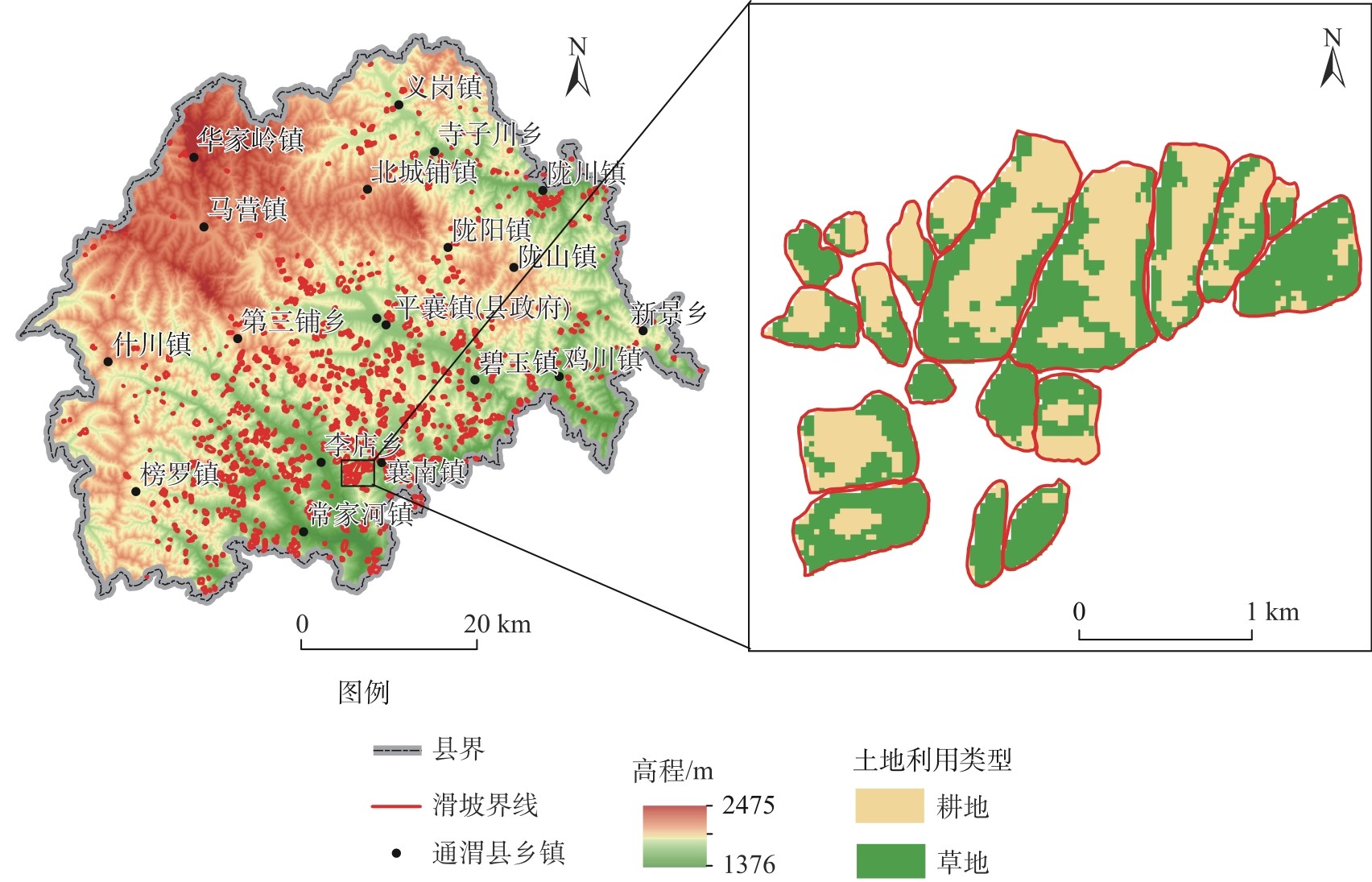
Fig. 1
Overview of the study area"
Tab. 1
Threat factor attributes"
| 威胁因子 | 最大影响距离/km | 影响权重 | 影响类型 |
|---|---|---|---|
| 耕地 | 4.0 | 0.6 | 指数 |
| 建设用地 | 10.0 | 1.0 | 指数 |
| 裸地 | 6.0 | 0.5 | 线性 |
Tab. 2
Habitat suitability and sensitivity"
| 土地利用类型 | 生境适宜性 | 耕地 | 裸地 | 建设用地 |
|---|---|---|---|---|
| 耕地 | 0.30 | 0.00 | 0.40 | 0.80 |
| 林地 | 1.00 | 0.60 | 0.20 | 0.80 |
| 草地 | 0.90 | 0.80 | 0.60 | 0.70 |
| 水域 | 0.70 | 0.50 | 0.40 | 0.70 |
| 裸地 | 0.50 | 0.06 | 0.00 | 0.60 |
| 建设用地 | 0.00 | 0.00 | 0.10 | 0.00 |
Tab. 3
Types of two-factor interaction"
| 判断依据 | 交互作用类型 |
|---|---|
| q(x1∩x2)<Min[q(x1), q(x2)] | 非线性减弱 |
| Min[q(x1), q(x2)]<q(x1∩x2)<Max[q(x1), q(x2)] | 单因子非线性减弱 |
| q(x1∩x2)>Max[q(x1), q(x2)] | 双因子增强 |
| q(x1∩x2)=q(x1)+q(x2) | 独立 |
| q(x1∩x2)>q(x1)+q(x2) | 非线性增强 |
Fig. 2
Contribution degree of driving factors"
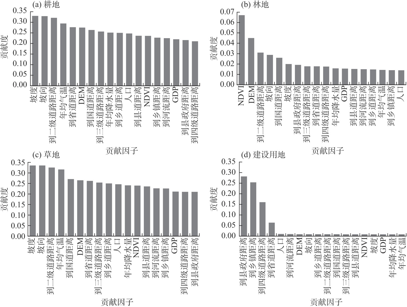
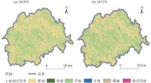
Fig. 3
Land use in Tongwei County from 2020 to 2035"
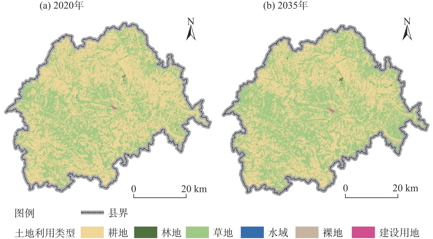
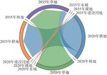
Fig. 4
Land use transition matrix in Tongwei County from 2020 to 2035"

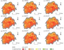
Fig. 5
Spatiotemporal patterns of habitat quality in Tongwei County from 1985 to 2035"

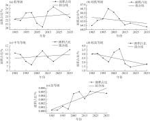
Fig. 6
Area proportions of each habitat quality grade in Tongwei County and its linear fitting from 1985 to 2035"
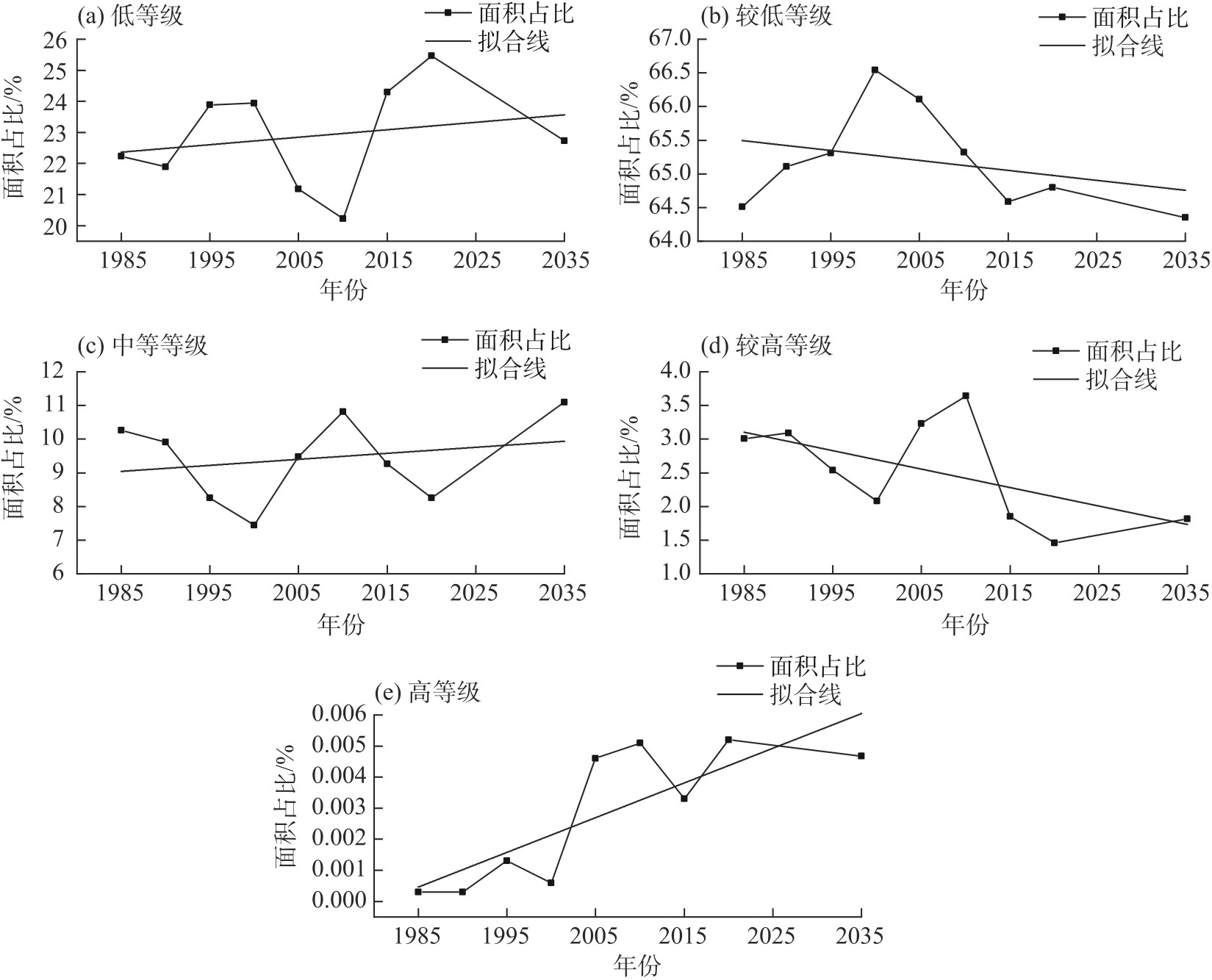

Fig. 7
Average habitat quality index and its linear fitting in Tongwei County from 1985 to 2035"
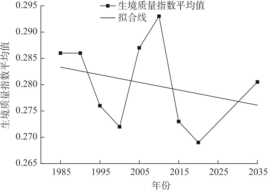
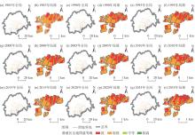
Fig. 8
Spatiotemporal patterns of habitat quality in landslide area from 1985 to 2035"

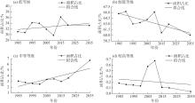
Fig. 9
Area proportions of each habitat quality grade in landslide area and its linear fitting from 1985 to 2035"
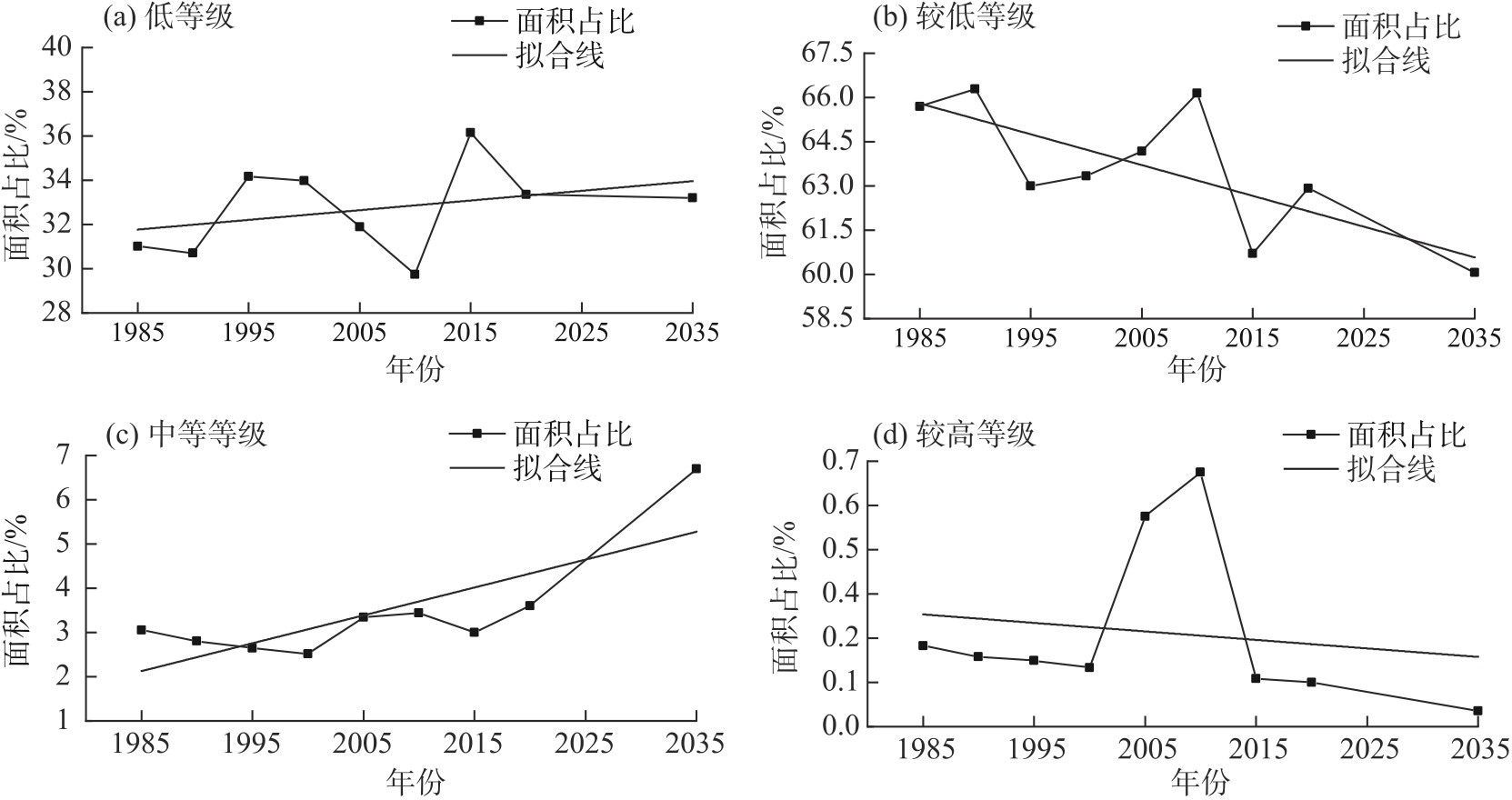
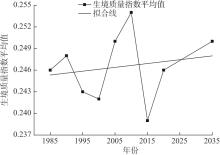
Fig. 10
Average habitat quality index and its linear fitting in landslide area from 1985 to 2035"
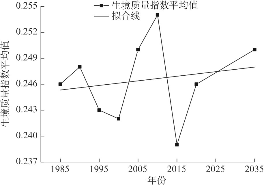
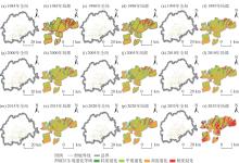
Fig. 11
Spatiotemporal patterns of habitat degradation in landslide area from 1985 to 2035"

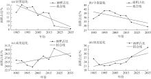
Fig. 12
Area proportions of each habitat degradation grade in landslide area and its linear fitting from 1985 to 2035"
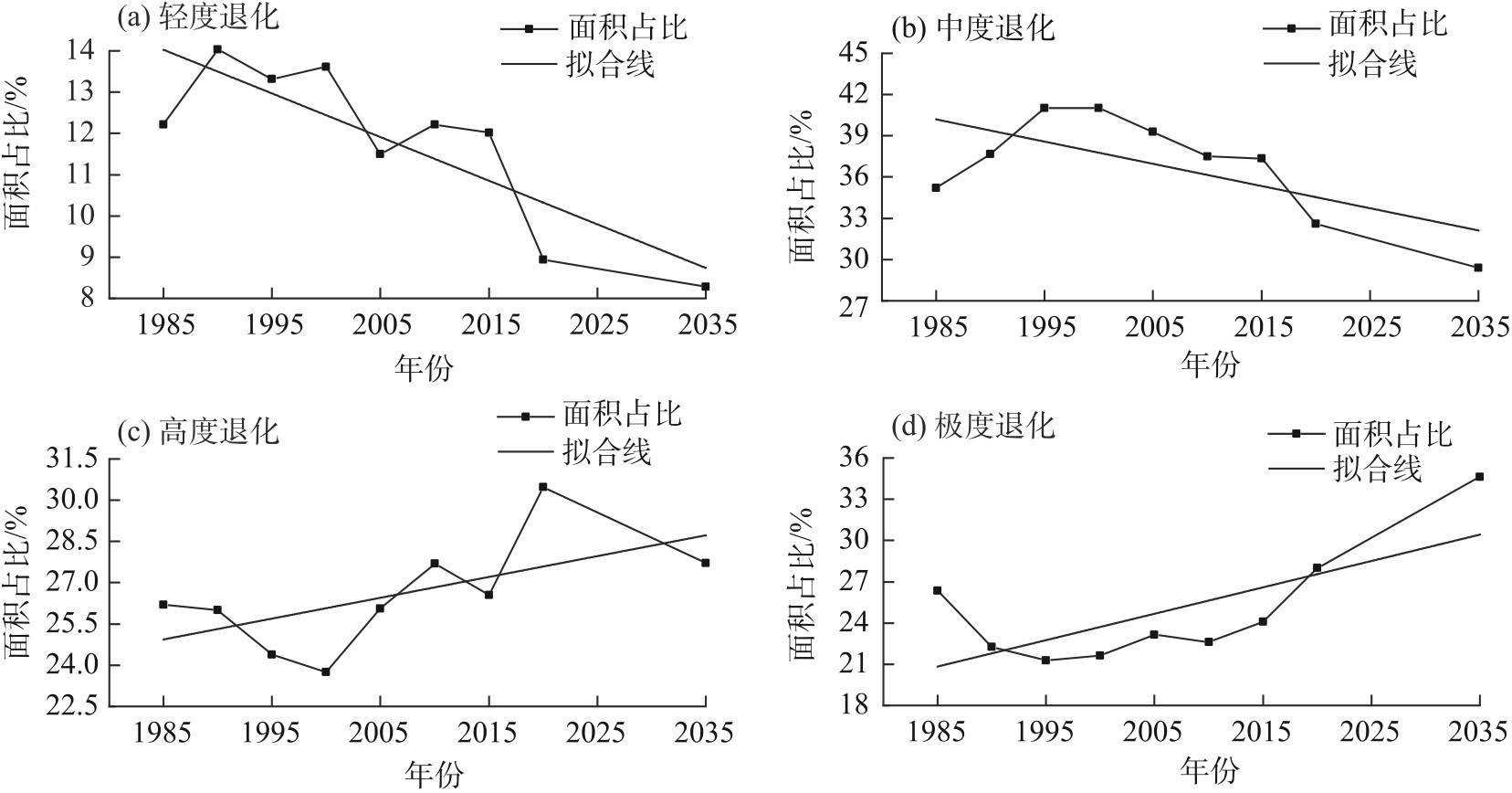

Fig. 13
Average habitat degradation index and its linear fitting in landslide area from 1985 to 2035"
Tab. 4
Results of single factor detection by geographic detector"
| 因子 | 年均气温 (X1) | 年均降水量(X2) | 坡度 (X3) | 坡向 (X4) | 蒸散发 (X5) | NDVI (X6) | DEM (X7) | 到河流距离(X8) | 人口 (X9) | GDP (X10) | 到道路距离 (X11) |
|---|---|---|---|---|---|---|---|---|---|---|---|
| q值 | 0.093 | 0.078 | 0.072 | 0.014 | 0.017 | 0.106 | 0.089 | 0.033 | 0.037 | 0.038 | 0.002 |
Tab. 5
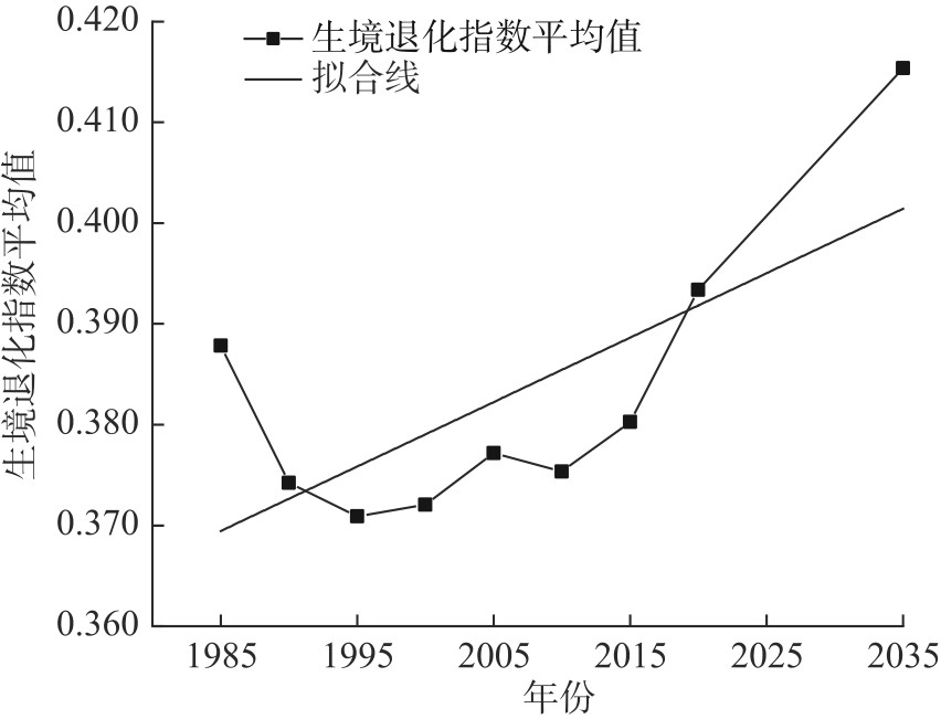
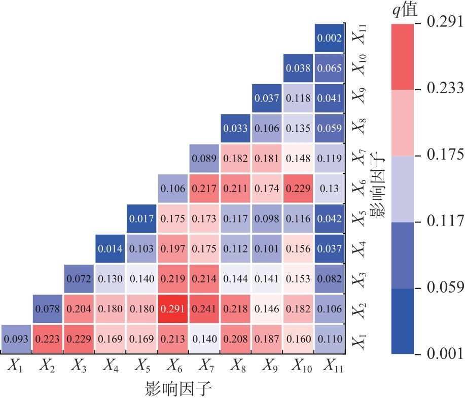
Results of interactive detection by geodetector"
| 主导交互因子 | X2∩X6 | X2∩X7 | X6∩X10 | X1∩X3 | X1∩X2 | X1∩X7 | X9∩X11 |
|---|---|---|---|---|---|---|---|
| q值 | 0.291 | 0.241 | 0.229 | 0.229 | 0.223 | 0.140 | 0.041 |
| 交互结果 | 非线性增强 | 非线性增强 | 非线性增强 | 非线性增强 | 非线性增强 | 双因子增强 | 双因子增强 |
Fig. 14
Interactive detection results of habitat quality influencing factors in landslide area"
| [1] | Prăvălie R. Drylands extent and environmental issues: A global approach[J]. Earth-Science Reviews, 2016, 161: 259-278. |
| [2] | 张燕, 梁进一, 韦玲霞, 等. 兰州市生态环境质量时空变化及驱动力分析[J]. 干旱区资源与环境, 2023, 37(10): 65-74. |
| [ Zhang Yan, Liang Jinyi, Wei Lingxia, et al. Change in spatial-temporal patterns of eco-environment quality and its driving forces for the Lanzhou City[J]. Journal of Arid Land Resources and Environment, 2023, 37(10): 65-74. ] | |
| [3] | 李旭春, 孛永明, 王丽洁, 等. 定西水土保持科研发展历程及未来展望[J]. 中国水土保持, 2023(11): 1-4. |
| [ Li Xuchun, Bo Yongming, Wang Lijie, et al. Development process and prospects of soil and water conservation research in Dingxi[J]. Soil and Water Conservation in China, 2023(11): 1-4. ] | |
| [4] | 张楠, 张岩, 王佳希, 等. 黄土丘陵沟壑区小流域侵蚀沟数量及形态特征[J]. 水土保持学报, 2023, 37(3): 109-115. |
| [ Zhang Nan, Zhang Yan, Wang Jiaxi, et al. Quantity and morphological parameters of gullies in small watersheds in the hilly-gully Loess Plateau[J]. Journal of Soil and Water Conservation, 2023, 37(3): 109-115. ] | |
| [5] | Newbold T, Hudson L N, Hill S L L, et al. Global effects of land use on local terrestrial biodiversity[J]. Nature, 2015, 520(7545): 45-50. |
| [6] | 郑贱成, 谢炳庚, 游细斌, 等. 1980—2020年粤港澳大湾区生境质量变化特征[J]. 经济地理, 2022, 42(8): 41-50. |
| [ Zheng Jiancheng, Xie Binggeng, You Xibin, et al. Evolution of habitat quality and its influencing factors in the different terrain gradient of the Guangdong-Hong Kong-Macao Greater Bay Area from 1980 to 2020[J]. Economic Geography, 2022, 42(8): 41-50. ] | |
| [7] | 张廷, 胡玉柱, 胡海辉, 等. 基于PLUS-InVEST模型的哈尔滨市土地利用及生境质量预测[J]. 环境科学, 2024, 45(8): 4709-4721. |
| [ Zhang Ting, Hu Yuzhu, Hu Haihui, et al. Prediction of land use and habitat quality in Harbin City based on the PLUS-InVEST model[J]. Environmental Science, 2024, 45(8): 4709-4721. ] | |
| [8] | 武爱彬, 陈辅国, 赵艳霞, 等. 京津冀城市群建设用地扩张多情景模拟及其对生态系统碳储量的影响[J]. 环境科学, 2024, 45(5): 2828-2839. |
| [ Wu Aibin, Chen Fuguo, Zhao Yanxia, et al. Multi-scenario simulation of construction land expansion and its impact on ecosystem carbon storage in Beijing-Tianjin-Hebei urban agglomeration[J]. Environmental Science, 2024, 45(5): 2828-2839. ] | |
| [9] | 赵霁雨, 崔柳, 王佳, 等. 基于土地利用模拟预测模型分析的城市绿色空间发展多情景模拟及建设时序研究——以湛江市中心城区为例[J]. 生态学报, 2023, 43(15): 6307-6320. |
| [ Zhao Jiyu, Cui Liu, Wang Jia, et al. Multi-scenario simulation of urban green space development and construction timeline based on PLUS model analysis: A case study of the central Zhanjiang City[J]. Acta Ecologica Sinica, 2023, 43(15): 6307-6320. ] | |
| [10] | 胡佶熹, 勒先文, 王卫林, 等. 基于PLUS-InVEST模型的江西省生态系统碳储量时空演变与预测[J]. 环境科学, 2024, 45(6): 3284-3296. |
| [ Hu Jixi, Le Xianwen, Wang Weilin, et al. Temporal and spatial evolution and prediction of ecosystem carbon storage in Jiangxi Province based on PLUS-InVEST model[J]. Environmental Science, 2024, 45(6): 3284-3296. ] | |
| [11] | 欧阳晓, 贺清云, 朱翔, 等. 多情景下模拟城市群土地利用变化对生态系统服务价值的影响——以长株潭城市群为例[J]. 经济地理, 2020, 40(1): 93-102. |
| [ Ouyang Xiao, He Qingyun, Zhu Xiang, et al. Simulation of impacts of urban agglomeration land use change on ecosystem services value under multi-scenarios: Case study in Changsha-Zhuzhou-Xiangtan urban agglomeration[J]. Economic Geography, 2020, 40(1): 93-102. ] | |
| [12] | 雒舒琪, 胡晓萌, 孙媛, 等. 耦合PLUS-InVEST模型的多情景土地利用变化及其对碳储量影响[J]. 中国生态农业学报, 2023, 31(2): 300-314. |
| [ Luo Shuqi, Hu Xiaomeng, Sun Yuan, et al. Multi-scenario land use change and its impact on carbon storage based oncoupled PLUS-InVEST model[J]. Chinese Journal of Eco-Agriculture, 2023, 31(2): 300-314. ] | |
| [13] | 程静, 王鹏, 陈红翔, 等. 渭河流域生境质量时空演变及其地形梯度效应与影响因素[J]. 干旱区地理, 2023, 46(3): 481-491. |
| [ Cheng Jing, Wang Peng, Chen Hongxiang, et al. Spatiotemporal evolution of habitat quality in the Weihe River Basin and its topographic gradient effects and influencing factors[J]. Arid Land Geography, 2023, 46(3): 481-491. ] | |
| [14] | 谢余初, 巩杰, 张素欣, 等. 基于遥感和InVEST模型的白龙江流域景观生物多样性时空格局研究[J]. 地理科学, 2018, 38(6): 979-986. |
| [ Xie Yuchu, Gong Jie, Zhang Suxin, et al. Spatiotemporal change of landscape biodiversity based on InVEST model and remote sensing technology in the Bailong River Watershed[J]. Scientia Geographica Sinica, 2018, 38(6): 979-986. ] | |
| [15] | 苏军德, 赵晓冏, 李国霞, 等. 祁连山国家自然保护区生境质量时空特征及驱动因素分析[J]. 中国环境科学, 2024, 44(5): 2595-2605. |
| [ Su Junde, Zhao Xiaojiong, Li Guoxia, et al. Spatial and temporal characteristics and driving factors of habitat quality in Qilian Mountain National Nature Reserve[J]. China Environmental Science, 2024, 44(5): 2595-2605. ] | |
| [16] | 严莉, 曹广超, 康利刚, 等. 基于InVEST模型的共和县生境质量时空变化及驱动因素[J]. 干旱区研究, 2024, 41(2): 314-325. |
| [ Yan Li, Cao Guangchao, Kang Ligang, et al. Analysis of spatial and temporal changes in habitat quality and driving factors in Gonghe County using the InVEST model[J]. Arid Zone Research, 2024, 41(2): 314-325. ] | |
| [17] | 张晓东, 武丹, 王莹, 等. 耦合InVEST与Geodetector模型的银川市生境质量时空演变特征及影响因子研究[J]. 干旱区地理, 2024, 47(7): 1242-1251. |
| [ Zhang Xiaodong, Wu Dan, Wang Ying, et al. Spatiotemporal evolution characteristics and influencing factors of habitat quality in Yinchuan City by coupling InVEST and Geodetector models[J]. Arid Land Geography, 2024, 47(7): 1242-1251. ] | |
| [18] | 王劲峰, 徐成东. 地理探测器: 原理与展望[J]. 地理学报, 2017, 72(1): 116-134. |
| [ Wang Jinfeng, Xu Chengdong. Geodetectors: Principles and prospects[J]. Acta Geographica Sinica, 2017, 72(1): 116-134. ] | |
| [19] | 圆圆, 盛艳, 刘林甫, 等. 窟野河流域生境质量时空演变特征及其影响机制研究[J]. 林草资源研究, 2023(6): 67-74. |
| [ Yuan Yuan, Sheng Yan, Liu Linfu, et al. Spatial-temporal evolution characteristics and driving influence mechanism of habitat quality in Kuye River Basin[J]. Forest and Grassland Resources Research, 2023(6): 67-74. ] | |
| [20] | 安文举, 鱼亦凡, 郝姗姗, 等. 基于土地利用变化的陕北多沙粗沙区生境质量演变及响应分析[J]. 干旱区地理, 2024, 47(3): 474-484. |
| [ An Wenju, Yu Yifan, Hao Shanshan, et al. Evolution and response analysis of habitat quality in more sediments and coarse sediments region of northern Shaanxi based on land use change[J]. Arid Land Geography, 2024, 47(3): 474-484. ] | |
| [21] | 吴艳霞, 刘方南, 陈宝童, 等. 黄河流域下游城市群生境质量时空演变及其驱动因素[J]. 水土保持通报, 2023, 43(4): 396-404. |
| [ Wu Yanxia, Liu Fangnan, Chen Baotong, et al. Spatial and temporal evolution and drivers of habitat quality of urban agglomeration in lower Yellow River Basin[J]. Bulletin of Soil and Water Conservation, 2023, 43(4): 396-404. ] | |
| [22] | 冀泳帆, 贾鲁净, 杨联安, 等. 耦合InVEST-PLUS模型的榆林市生境质量时空演变及预测分析[J]. 水土保持学报, 2023, 37(1): 123-132. |
| [ Ji Yongfan, Jia Lujing, Yang Lianan, et al. Spatio-temporal evolution and prediction analysis of habitat quality in Yulin City coupled with InVEST-PLUS model[J]. Journal of Soil and Water Conservation, 2023, 37(1): 123-132. ] | |
| [23] | Gong J, Xie Y C, Cao E J, et al. Integration of InVEST-habitat quality model with landscape pattern indexes to assess mountain plant biodiversity change: A case study of Bailongjiang Watershed in Gansu Province[J]. Journal of Geographical Science, 2019, 29(7): 1193-1210. |
| [24] | 高丽萍. 通渭县实施退耕还林工程及后续产业项目的初步成效分析[J]. 农业科技与信息, 2010(12): 43-44. |
| [ Gao Liping. Preliminary results analysis of the implementation of Grain for Green Project and subsequent industrial projects in Tongwei County[J]. Agricultural Science-Technology and Information, 2010(12): 43-44. ] | |
| [25] | 周蓉, 闫月娥, 周晓雷, 等. 甘肃通渭县退耕还林示范点造林成效定量分析[J]. 甘肃科技, 2005(5): 22-23. |
| [ Zhou Rong, Yan Yue’e, Zhou Xiaolei, et al. Quantitative analysis of afforestation effectiveness in demonstration site of returning farmland to forest in Tongwei County, Gansu Province[J]. Gansu Science and Technology, 2005(5): 22-23. ] | |
| [26] | 周业泽, 秦天, 裴阳, 等. 基于PLUS模型与地表基质的土地利用变化模拟与多情景预测[J]. 地质论评, 2024, 70(增刊1): 315-318. |
| [ Zhou Yeze, Qin Tian, Pei Yang, et al. Land use simulation and multi-scenario prediction based on PLUS model and ground substrate[J]. Geological Review, 2024, 70(Suppl. 1): 315-318. ] | |
| [27] | 熊亮华, 陈晋. 联产承包——冒风险农民自发包产到户解争端中央推进农村改革[J]. 新湘评论, 2020(13): 49-53. |
| [ Xiong Lianghua, Chen Jin. Household contract responsibility system: Farmers spontaneously contract production to households disputes resolved by Central Committee of CPC to promote rural reform[J]. Xinxiang Review, 2020(13): 49-53. ] | |
| [28] | 王娟, 张华兵, 李玉凤, 等. 盐城黄海湿地丹顶鹤越冬生境质量评估与管理对策研究[J]. 湿地科学, 2022, 20(3): 334-340. |
| [ Wang Juan, Zhang Huabing, Li Yufeng, et al. Assessment on overwintering habitat quality of red-crowned cranes in Yellow Sea wetlands in Yancheng and its management strategies[J]. Wetland Science, 2022, 20(3): 334-340. ] | |
| [29] | 赵晓冏, 王建, 苏军德, 等. 基于InVEST模型和莫兰指数的甘肃省生境质量与退化度评估[J]. 农业工程学报, 2020, 36(18): 301-308. |
| [ Zhao Xiaojiong, Wang Jian, Su Junde, et al. Assessment of habitat quality and degradation degree based on InVEST model and Moran index in Gansu Province, China[J]. Transactions of the Chinese Society of Agricultural Engineering, 2020, 36(18): 301-308. ] | |
| [30] | 朱增云, 阿里木江·卡斯木. 基于地理探测器的伊犁谷地生境质量时空演变及其影响因素[J]. 生态学杂志, 2020, 39(10): 3408-3420. |
| [ Zhu Zengyun, Kasimu Alimujiang. Spatial-temporal evolution of habitat quality in Yili Valley based on geographical detector and its influencing factors[J]. Chinese Journal of Ecology, 2020, 39(10): 3408-3420. ] |
|
||