Arid Land Geography ›› 2024, Vol. 47 ›› Issue (11): 1852-1862.doi: 10.12118/j.issn.1000-6060.2023.721
• The Third Xinjiang Scientific Expedition • Previous Articles Next Articles
YAN Zhaojin1,2,3( ), SUN Yuqing1(), HE Rong4, WANG Ran1,3, RUAN Xiaoguang5, YANG Hui1,3, CI Hui1,3
Received:2023-12-20
Revised:2024-01-02
Online:2024-11-25
Published:2024-12-03
Contact:
SUN Yuqing
E-mail:yanzhaojin@cumt.edu.cn;ts22010146p31@cumt.edu.cn
YAN Zhaojin, SUN Yuqing, HE Rong, WANG Ran, RUAN Xiaoguang, YANG Hui, CI Hui. Evaluation of land cover data product accuracy in urban agglomeration on the northern slope of Tianshan Mountains in Xinjiang[J].Arid Land Geography, 2024, 47(11): 1852-1862.
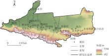
Fig. 1
Schematic diagram of the study area"

Tab. 1
Parameters of land cover data products"
| 产品名称 | 来源 | 分辨率/m | 区域 | 制图单位 | 生产年份 | 分类方法 | 参考数据 | 分类体系 (类别数量) |
|---|---|---|---|---|---|---|---|---|
| FROM-GLC10 | | 10 | 全球 | 清华大学 | 2017 | 随机森林 | Sentinel-2 | LCCS(10) |
| ESA10 | | 10 | 全球 | 欧空局及全球多家科研机构 | 2020 | 随机森林 | Sentinel-1 Sentinel-2 | LCCS(8) |
| Esri10 | | 10 | 全球 | Esri,撞击观测站 | 2020 | 深度学习 | Sentinel-2 | LCCS(11) |
| GLC_FCS30 | | 30 | 全球 | 中国科学院空天信息创新研究院 | 2020 | 监督分类 | Landsat、Sentinel-1 | LCCS(29) |
| Globe30 | | 30 | 全球 | 国家基础地理信息中心等 | 2020 | 监督分类 | Landsat | LCCS(10) |
| CLCD30 | | 30 | 中国 | 武汉大学 | 2020 | 随机森林 | Landsat | LCCS(9) |
Tab. 2
Classification system and harmonized classification system for the six land cover data products"
| 产品 | FROM-GLC10 | GLC_FCS30 | CLCD30 | ESA10 | Globe30 | Esri10 | 统一类别 |
|---|---|---|---|---|---|---|---|
| 类型 | 耕地 | 旱作农田、灌溉农田 | 耕地 | 耕地 | 农地 | 耕地 | 耕地 |
| 草地 | 草地、稀疏草丛、稀疏植被、草本覆盖 | 草地 | 草地 | 草地、苔原 | 牧场 | 草地 | |
| 灌木 | 灌木地、常绿灌木地 | 灌木 | 灌木 | 灌丛 | 牧场 | 草地 | |
| 林地 | 开阔常绿阔叶林、封闭落叶阔叶林、开阔常绿针叶林、封闭常绿针叶林、开阔落叶针叶林、封闭落叶针叶林、 | 林地 | 林地 | 森林 | 树木 | 林地 | |
| 湿地 | 地衣苔藓、湿地 | 湿地 | 湿地、苔藓 | 湿地 | 淹没植被 | 湿地 | |
| 水体 | 水体 | 水域 | 永久水体 | 水体 | 水体 | 水体 | |
| 不透水面 | 不透水表面 | 建设用地 | 建筑 | 不透水层 | 建筑 | 建筑 | |
| 裸地 | 裸地、固定裸地、不固定裸地 | 裸地 | 荒漠 | 裸地 | 裸地 | 裸地 | |
| 雪/冰 | 永久冻土/雪原 | 冰川 | 雪和冰 | 冰雪 | 冰/雪 | 冰/雪 | |
| - | - | - | - | - | 云 | - |
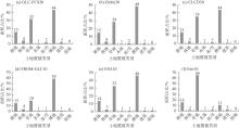
Fig. 2
Area proportion of each land type in the six land cover data products"
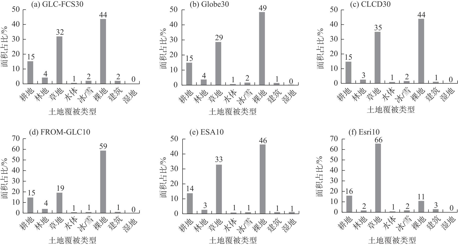

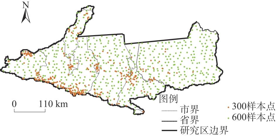
Fig. 3
Sample point distribution"
Tab. 3
Total accuracy and Kappa coefficient of the six land cover data products"
| 精度指标 | GLC-FCS30 | Globe30 | CLCD30 | FROM-GLC10 | ESA10 | Esri10 |
|---|---|---|---|---|---|---|
| 总精度 | 0.8080 | 0.8147 | 0.7880 | 0.8531 | 0.8047 | 0.4725 |
| Kappa系数 | 0.7128 | 0.7142 | 0.6802 | 0.7624 | 0.6986 | 0.3038 |
Fig. 4
Classification accuracy of the six land cover data products"
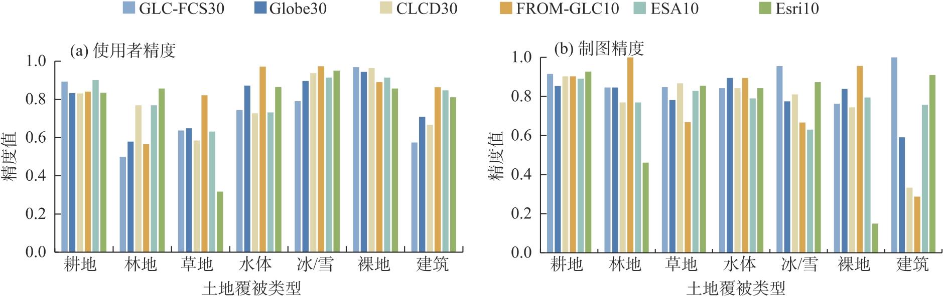
Fig. 5
Category confusion for the six land cover data products"
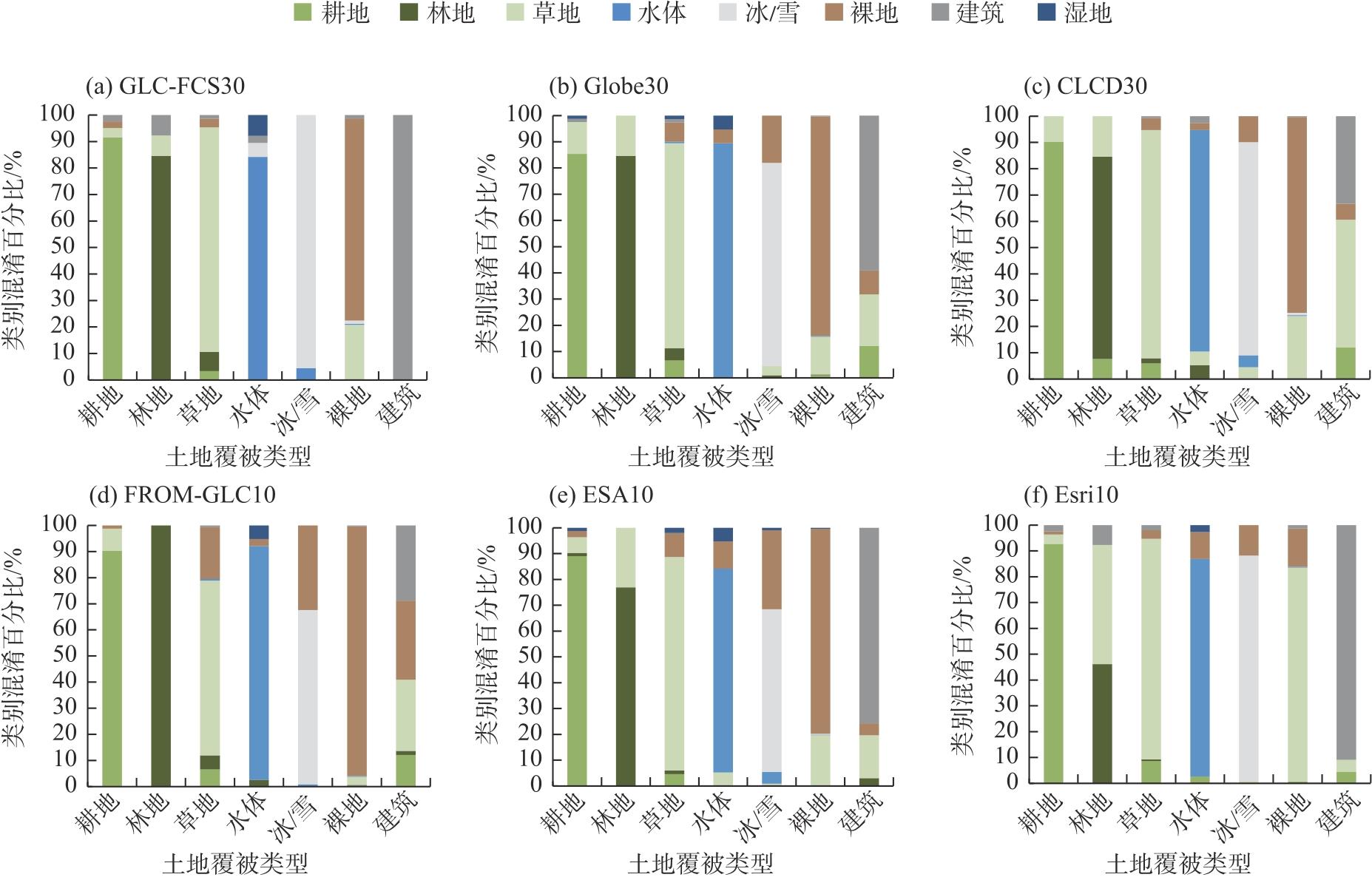
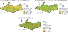
Fig. 6
Consistent spatial distribution of the six land cover data products"
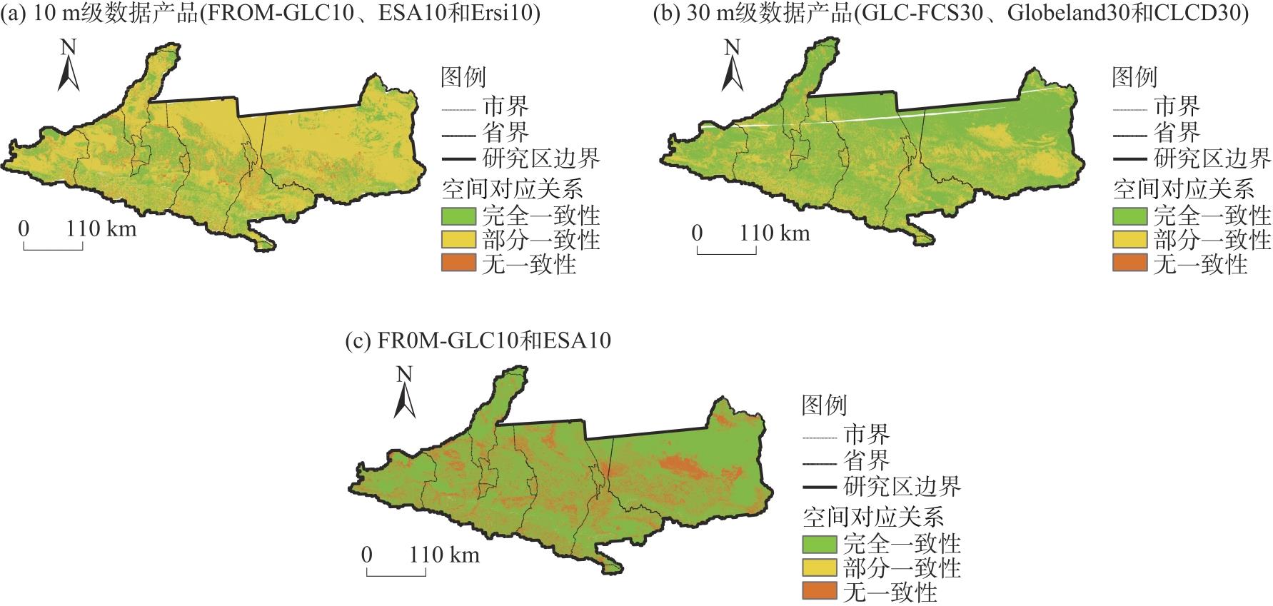
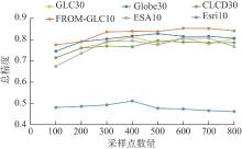
Fig. 7
Overall accuracy of land cover data products at different numbers of sampling points"
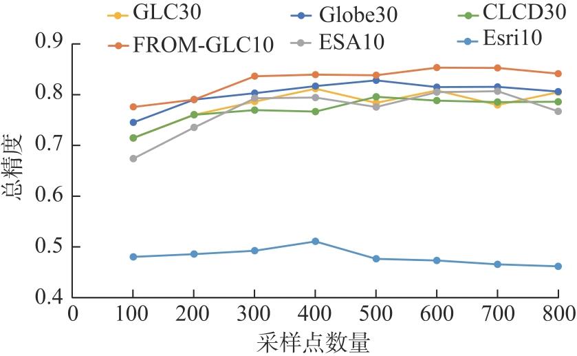
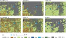
Fig. 8
Comparison of urban regions for each data product"

| [1] | Wei H, Xiong L Y, Tang G A, et al. Spatial-temporal variation of land use and land cover change in the glacial affected area of the Tianshan Mountains[J]. CATENA, 2021, 202: 105256, doi: 10.1016/j.catena.2021.105256. |
| [2] | Li M J, He F N, Zhao C H, et al. Evaluation of global historical cropland datasets with regional historical evidence and remotely sensed satellite data from the Xinjiang area of China[J]. Remote Sensing, 2022, 14(17): 4226, doi: 10.3390/rs14174226. |
| [3] | MohanRajan S N, Loganathan A, Manoharan P. Survey on land use/land cover (LU/LC) change analysis in remote sensing and GIS environment: Techniques and challenges[J]. Environmental Science and Pollution Research, 2020, 27(24): 29900-29926. |
| [4] |
郭紫燕, 杨康, 刘畅, 等. 巴基斯坦土地覆盖数据产品季节性精度评价[J]. 遥感技术与应用, 2020, 35(3): 567-575.
doi: 10.11873/j.issn.1004-0323.2020.3.0567 |
| [Guo Ziyan, Yang Kang, Liu Chang, et al. Seasonal accuracy assessments of three land cover datasets in Pakistan[J]. Remote Sensing Technology and Application, 2020, 35(3): 567-575.] | |
| [5] |
Yang J, Huang X. The 30 m annual land cover dataset and its dynamics in China from 1990 to 2019[J]. Earth System Science Data, 2021, 13(8): 3907-3925.
doi: 10.5194/essd-13-3907-2021 |
| [6] | Yu L, Du Z R, Dong R M, et al. FROM-GLC plus: Toward near real-time and multi-resolution land cover mapping[J]. GIScience & Remote Sensing, 2022, 59(1): 1026-1047. |
| [7] |
Zhang X, Liu L Y, Chen X D, et al. GLC_FCS30: Global land-cover product with fine classification system at 30 m using time-series Landsat imagery[J]. Earth System Science Data, 2021, 13(6): 2753-2776.
doi: 10.5194/essd-13-2753-2021 |
| [8] | Gong P, Liu H, Zhang M N, et al. Stable classification with limited sample: Transferring a 30 m resolution sample set collected in 2015 to mapping 10 m resolution global land cover in 2017[J]. Science Bulletin, 2019, 64(6): 370-373. |
| [9] | Karra K, Kontgis C, Statman-Weil Z, et al. Global land use/land cover with Sentinel 2 and deep learning[C]// IEEE International Geoscience and Remote Sensing Symposium IGARSS. Brussels, Belgium: IEEE, 2021: 4704-4707. |
| [10] | Daniele Z, van de Ruben K, de Wanda K, et al. ESA World Cover 10 m 2020 v100[DB/OL]. [2023-12-10]. https://doi.org/10.5281/zenodo.5571936. |
| [11] | Stehman S V, Foody G M. Key issues in rigorous accuracy assessment of land cover products[J]. Remote Sensing of Environment, 2019, 231(10): 111199, doi: 10.1016/j.rse.2019.05.018. |
| [12] | Gao Y, Liu L Y, Zhang X, et al. Consistency analysis and accuracy assessment of three global 30 m land cover products over the European Union using the Lucas dataset[J]. Remote Sensing, 2020, 12(21): 3479, doi: 10.3390/rs12213479. |
| [13] | Ran Y H, Li X, Lu L. Evaluation of four remote sensing based land cover products over China[J]. International Journal of Remote Sensing, 2010, 31(2): 391-401. |
| [14] |
Li Z W, Chen X Y, Qi J, et al. Accuracy assessment of land cover products in China from 2000 to 2020[J]. Scientific Reports, 2023, 13(1): 12936, doi: 10.1038/s41598-023-39963-0.
pmid: 37558712 |
| [15] | 康军梅. 多源遥感土地覆被产品一致性评价及要素提取分析应用研究[D]. 西安: 长安大学, 2020. |
| [Kang Junmei. Research on consistency assessment of multi-source land cover poducts and application of element extraction analysis[D]. Xi’an: Chang’an University, 2020.] | |
| [16] | 付东光, 李登秋, 陆灯盛, 等. 基于调查数据的福建省3种30 m全球土地覆盖产品精度评价[J]. 福建师范大学学报(自然科学版), 2023, 39(2): 122-136. |
| [Fu Dongguang, Li Dengqiu, Lu Dengsheng, et al. Accuracy assessment of three 30 m resolution global land cover products in Fujian Province based on survey data[J]. Journal of Fujian Normal University (Natural Science Edition), 2023, 39(2): 122-136.] | |
| [17] | 闫明, 庞勇, 何云玲, 等. 普洱多源土地覆盖产品一致性分析与精度评价[J]. 林业资源管理, 2023(1): 173-182. |
| [Yan Ming, Pang Yong, He Yunling, et al. Consistency analysis and accuracy evaluation of multi-source land cover products in Pu’er[J]. Forest Resource Management, 2023(1): 173-182.] | |
| [18] | Liang L, Liu Q S, Liu G H, et al. Accuracy evaluation and consistency analysis of four global land cover products in the Arctic region[J]. Remote Sensing, 2019, 11(12): 1396, doi: 10.3390/rs11121396. |
| [19] |
侯婉, 侯西勇. 全球海岸带多源土地利用覆盖遥感分类产品一致性分析[J]. 地球信息科学学报, 2019, 21(7): 1061-1073.
doi: 10.12082/dqxxkx.2019.180441 |
| [Hou Wan, Hou Xiyong. Consistency of the multiple remote sensing-based land use and land cover classification products in the global coastal zones[J]. Journal of Geo-information Science, 2019, 21(7): 1061-1073.] | |
| [20] | 吴宗洋, 蔡卓雅, 郭英, 等. 黄河流域多源遥感土地覆被数据精度评价与一致性分析[J]. 中国生态农业学报, 2023, 31(6): 917-927. |
| [Wu Zongyang, Chai Zhuoya, Guo Ying, et al. Accuracy evaluation and consistency analysis on multi-source remote sensing land cover data in the Yellow River Basin[J]. Chinese Journal of Eco-Agriculture, 2023, 31(6): 917-927.] | |
| [21] | 夏文韬, 王莺, 冯琦胜, 等. 甘南地区MODIS土地覆盖产品精度评价[J]. 草业科学, 2010, 27(9): 11-18. |
| [Xia Wentao, Wang Ying, Feng Qisheng, et al. Accuracy assessment of MODIS land cover product of Gannan Prefecture[J]. Grassland Science, 2010, 27(9): 11-18.] | |
| [22] | Wang X, Wang J, Wang W, et al. Consistency and accuracy evaluation analysis of four cropland cover products: A case study of Indochina Peninsula[J]. Journal of Sensors, 2022(24): 1-25. |
| [23] |
李美娇, 何凡能, 赵彩杉, 等. 全球历史LUCC数据集新疆地区耕地数据可靠性评估[J]. 生态环境学报, 2022, 31(6): 1215-1224.
doi: 10.16258/j.cnki.1674-5906.2022.06.018 |
| [Li Meijiao, He Fanneng, Zhao Caishan, et al. Credibility assessment of cropland data in Xinjiang area in global historical LUCC datasets[J]. Journal of Ecology and Environment, 2022, 31(6): 1215-1224.] | |
| [24] | 陈逸聪, 邵华, 李杨. 多源土地覆被产品在长三角地区的一致性分析与精度评价[J]. 农业工程学报, 2021, 37(6): 142-150. |
| [Chen Yicong, Shao Hua, Li Yang. Consistency analysis and accuracy assessment of multi-source land cover products in the Yangtze River Delta[J]. Journal of Agricultural Engineering, 2021, 37(6): 142-150.] | |
| [25] | Lu M, Wu W B, Zhang L, et al. A comparative analysis of five global cropland datasets in China[J]. Science China Earth Sciences, 2016, 59(12): 2307-2317. |
| [26] |
黄亚博, 廖顺宝. 首套全球30 m分辨率土地覆被产品区域尺度精度评价——以河南省为例[J]. 地理研究, 2016, 35(8): 1433-1446.
doi: 10.11821/dlyj201608003 |
| [Huang Yabo, Liao Shunbao. Regional accuracy assessments of the first global land cover dataset at 30-meter resolution: A case study of Henan Province[J]. Geography Research, 2016, 35(8): 1433-1446.] | |
| [27] | 宋宏利, 张晓楠. 国家尺度异源土地覆被遥感产品精度评价[J]. 国土资源遥感, 2018, 30(3): 26-32. |
| [Song Hongli, Zhang Xiaonan. Precision validation of multi-sources land cover products derived from remote sensing[J]. Remote Sensing of Land Resources, 2018, 30(3): 26-32.] | |
| [28] | 黄亚博. 基于多源数据融合的MODIS土地覆被产品精度评价与改进方法研究[D]. 开封: 河南大学, 2017. |
| [Huang Yabo. Research on MODIS land cover product accuracy evaluation and improvement method based on mult-source data fusion[D]. Kaifeng: Henan University, 2017.] | |
| [29] | 宋宏利, 张晓楠. 基于VGI的土地覆被遥感产品精度验证[J]. 河北工程大学学报(自然科学版), 2016, 33(4): 98-102. |
| [Song Hongli, Zhang Xiaonan. Analysis of land cover category accuracy based on volunteered geographic information[J]. Journal of Hebei University of Engineering (Natural Science Edition), 2016, 33(4): 98-102.] | |
| [30] |
杨梅花, 程锦涛, 郭佳星, 等. 新疆城市规模分布与自然地理相关性分析[J]. 干旱区地理, 2022, 45(6): 1958-1967.
doi: 10.12118/j.issn.1000-6060.2022.115 |
|
[Yang Meihua, Cheng Jintao, Guo Jiaxing, et al. Correlation analysis between urban scale distribution and physicalgeography in Xinjiang[J]. Arid Land Geography, 2022, 45(6): 1958-1967.]
doi: 10.12118/j.issn.1000-6060.2022.115 |
|
| [31] | Ma H L, Sun J G. The influence of LUCC on water demand in the north slope of Tianshan Mountain, IOP Conference Series: Earth and environmental science[J]. IOP Publishing, 2020, 560(1): 012079, doi: 10.1088/1755-1315/560/1/012079. |
| [32] |
孙桂丽, 陆海燕, 郑佳翔, 等. 新疆生态脆弱性时空演变及驱动力分析[J]. 干旱区研究, 2022, 39(1): 258-269.
doi: 10.13866/j.azr.2022.01.25 |
|
[Sun Guili, Lu Haiyan, Zheng Jiaxiang, et al. Spatio-temporal variation of ecological vulnerability in Xinjiang and driving force analysis[J]. Arid Zone Research, 2022, 39(1): 258-269.]
doi: 10.13866/j.azr.2022.01.25 |
| [1] | YU Kaixin, LI Jifeng, ZHEN Tianle, ZHANG Xialei, LI Huiru, GUO Zhongling, CHANG Chunping, ZHAO Xueqing. Estimation of crop stubble biomass in the Bashang region of Zhangjiakou by combining optics and radar remote sensing [J]. Arid Land Geography, 2025, 48(3): 455-466. |
| [2] | TANG Yandong, ZANG Cuiping, YU Yunpeng, YU Qinglin. Developmental characteristics and influencing factors of gullies based on fractal theory in eastern Gansu Province [J]. Arid Land Geography, 2025, 48(2): 223-233. |
| [3] | LIU Wei, LING Hongbo, GONG Yanming, CHEN Fulong, SHAN Qianjuan. Evaluation of ecological environment quality in the mainstream of Tarim River based on improved remote sensing ecological index [J]. Arid Land Geography, 2025, 48(2): 271-282. |
| [4] | XIE Junbo, WANG Xingpeng, HE Shuai, LIU Yang, ZHONG Zhibo, LI Yan, HONG Guojun. Soil salinity inversion in the Shajingzi irrigation district based on spectral index modeling [J]. Arid Land Geography, 2024, 47(7): 1199-1209. |
| [5] | LYU Na, GUO Mengjing, ZHAO Xin, LIU Kele, HUANG Yujia. Remote sensing inversion of water quality and spatiotemporal evolution characteristics of the Bosten Inland Freshwater Lake [J]. Arid Land Geography, 2024, 47(6): 953-966. |
| [6] | HUANG Manjie, LI Yanzhong, WANG Yuangang, YU Zhiguo, ZHUANG Jiacheng, XING Yincong. Evaluation of meteorological drought performance of multisource remote-sensing precipitation products in arid northwest China [J]. Arid Land Geography, 2024, 47(4): 549-560. |
| [7] | LIU Ruiliang, JIA Keli, LI Xiaoyu, CHEN Ruihua, WANG Yijing, ZHANG Junhua. Inversion of soil salt content by combining optical and microwave remote sensing in cultivated land [J]. Arid Land Geography, 2024, 47(3): 433-444. |
| [8] | WANG Jian, GUAN Yao, HE Xinghong, DAI Yunhao, CHEN Yiwei, WANG Yuqiang, LI Huiwen, FAN Debao. Dynamic monitoring and evaluation of ecological environment quality in Tumshuk City from 2000 to 2021 [J]. Arid Land Geography, 2024, 47(3): 465-473. |
| [9] | LI Shijiao, ZHANG Keke, XIE Baoni, WANG Shiwen, LI Zhiguang. Ecological environment quality evaluation and driving factors of Korla region based on remote sensing [J]. Arid Land Geography, 2024, 47(12): 2064-2074. |
| [10] | TANG Taibin, ZHOU Bao, JIN Xiaomei, WEI Sailajia, MA Tao, ZHANG Yongyan. Change of surface temperature in the source area of the Yellow River in summer [J]. Arid Land Geography, 2023, 46(8): 1250-1259. |
| [11] | CHENG Shuo, LI Yanzhong, XING Yincong, YU Zhiguo, WANG Yuangang, HUANG Manjie. Simulation performance of remote sensing precipitation products on hydrological drought characteristics in the source region of the Yellow River [J]. Arid Land Geography, 2023, 46(7): 1063-1072. |
| [12] | YANG Xuewen, WANG Ninglian, LIANG Qian, CHEN An’an. Glacier changes on the north slope of Tianshan Mountains in recent 60 years [J]. Arid Land Geography, 2023, 46(7): 1073-1083. |
| [13] | LI Shiyao, CONG Shixiang, WANG Rongrong, YU Hailong, HUANG Juying. Monitoring of maize canopy SPAD value under drought stress based on UAV multi-spectral remote sensing [J]. Arid Land Geography, 2023, 46(7): 1121-1132. |
| [14] | TIAN Liulan, WANG Shanshan, WU Zhaopeng. Construction of ecological security pattern in Urumqi based on multi-temporal remote sensing data [J]. Arid Land Geography, 2023, 46(7): 1155-1165. |
| [15] | DONG Jiefang, ZHANG Kaili, QU Xueshu, RUAN Zheng. Measurement and influencing factors of ecological well-being performance of cities in Yellow River Basin [J]. Arid Land Geography, 2023, 46(5): 834-845. |
|
||