Arid Land Geography ›› 2024, Vol. 47 ›› Issue (8): 1314-1326.doi: 10.12118/j.issn.1000-6060.2023.404
• The Third Xinjiang Scientific Expedition • Previous Articles Next Articles
Gulzar MOMIN1,2( ), YANG Lianmei2(), LIU Yan2, LI Xinguo1
Received:2023-08-05
Revised:2023-10-07
Online:2024-08-25
Published:2024-09-02
Contact:
YANG Lianmei
E-mail:gz2233711745@163.com;yanglm@idm.cn
Gulzar MOMIN, YANG Lianmei, LIU Yan, LI Xinguo. Spatial and temporal distribution of flood disasters and characteristics of disaster-prone environment in Ili River Basin in recent 30 years[J].Arid Land Geography, 2024, 47(8): 1314-1326.
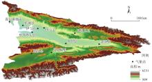
Fig. 1
Schematic diagram of the study area"

Tab. 1
Data sources"
| 名称 | 分辨率/m | 年份 | 数据来源 |
|---|---|---|---|
| 洪水灾情数据集 | - | 1990—2022 | 中国气象局“气象灾情管理系统”、新疆气象灾害大典 |
| 数字高程模型 | 30 | 2010 | 地理空间数据云 |
| 土地利用类型 | 30 | 2020 | 中国科学院资源环境科学数据中心( |
| 生长季(6—9月)NDVI平均值 | 250 | 2020 | NASA官方网站modis13Q1数据 |
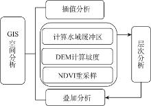
Fig. 2
Research technical route"
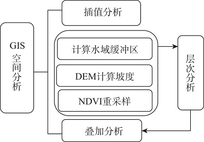
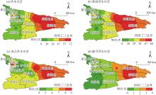
Fig. 3
Spatial distribution of flood disasters types in Ili River Basin from 1990 to 2022"
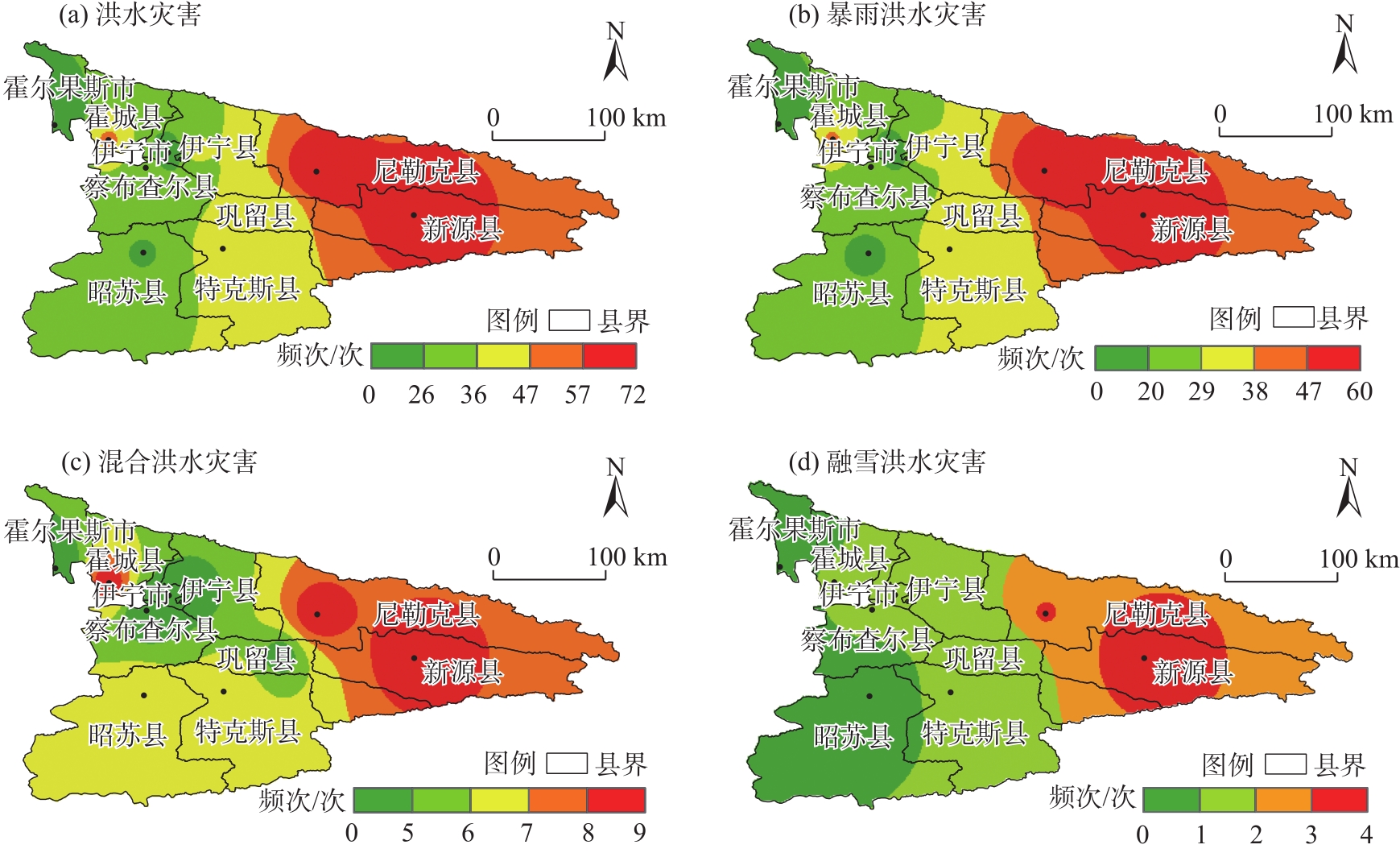
Tab. 2
County distribution frequency of flood disaster types /次"
| 灾害类型 | 新源县 | 尼勒克县 | 巩留县 | 特克斯县 | 伊宁县 | 伊宁市 | 察布查尔县 | 昭苏县 | 霍城县 | 霍尔果斯市 |
|---|---|---|---|---|---|---|---|---|---|---|
| 暴雨 | 55 | 60 | 34 | 32 | 33 | 9 | 28 | 18 | 39 | 0 |
| 混合 | 9 | 9 | 5 | 7 | 5 | 5 | 4 | 7 | 9 | 4 |
| 融雪 | 4 | 3 | 1 | 1 | 1 | 1 | 1 | 0 | 1 | 0 |
| 总计 | 68 | 72 | 40 | 40 | 39 | 15 | 33 | 25 | 49 | 4 |
Fig. 4
Seasonal spatial distribution of flood disasters in Ili River Basin from 1990 to 2022"
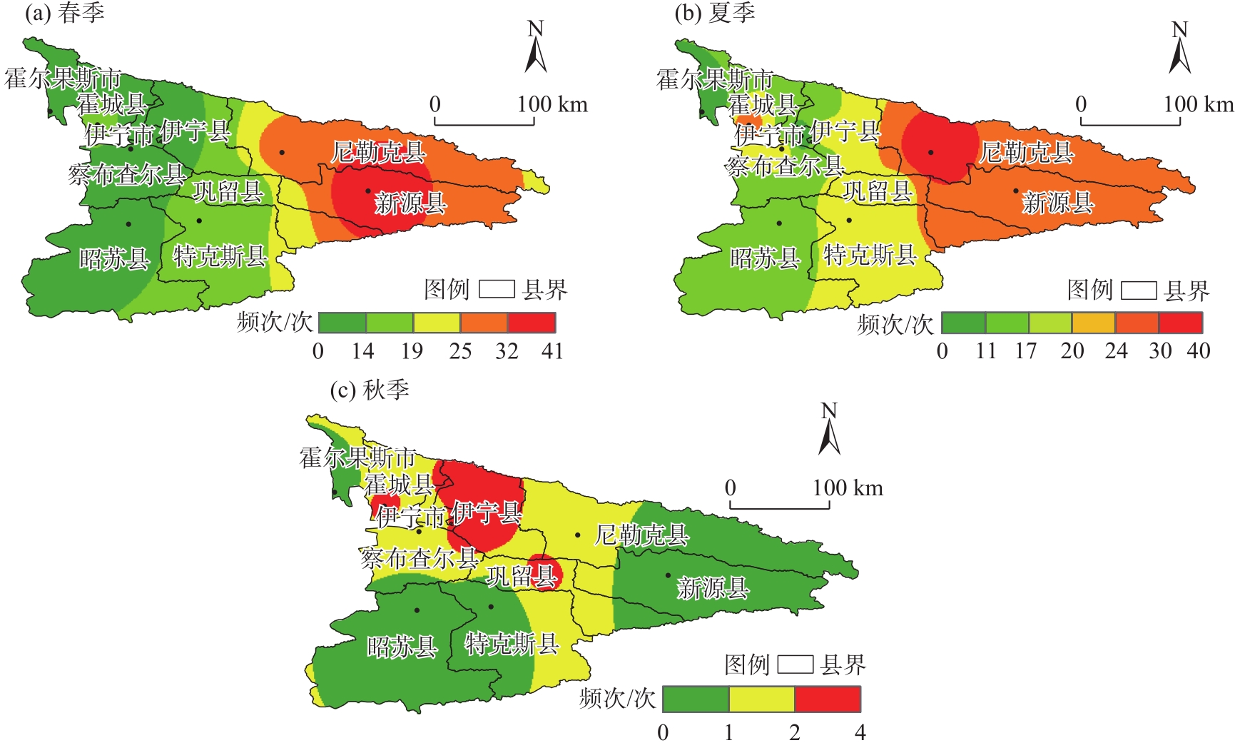
Tab. 3
Seasonal distribution frequency of flood disasters /次"
| 季节 | 新源县 | 尼勒克县 | 巩留县 | 特克斯县 | 伊宁县 | 伊宁市 | 察布查尔县 | 昭苏县 | 霍城县 | 霍尔果斯市 |
|---|---|---|---|---|---|---|---|---|---|---|
| 春季 | 41 | 31 | 16 | 17 | 13 | 7 | 9 | 11 | 19 | 3 |
| 夏季 | 27 | 40 | 22 | 23 | 22 | 7 | 23 | 14 | 28 | 1 |
| 秋季 | 0 | 1 | 2 | 0 | 4 | 1 | 1 | 0 | 2 | 0 |
| 总计 | 68 | 72 | 40 | 40 | 39 | 15 | 33 | 25 | 49 | 4 |
Fig. 5
Seasonal spatial distribution of rainstorm flood disaster in Ili River from 1990 to 2022"

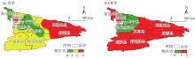
Fig. 6
Seasonal spatial distribution of mixed flood disaster in Ili River from 1990 to 2022"
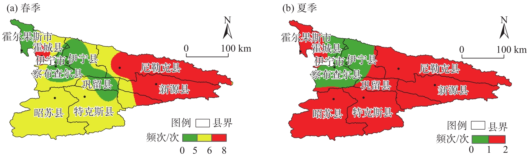
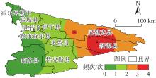
Fig. 7
Spring spatial distribution of snowmelt flood disaster in Ili River from 1990 to 2022"

Tab. 4
Seasonal distribution frequency of three types of flood disasters /次"
| 灾害类型 | 新源县 | 尼勒克县 | 巩留县 | 特克斯县 | 伊宁县 | 伊宁市 | 察布查尔县 | 昭苏县 | 霍城县 | 霍尔果斯市 |
|---|---|---|---|---|---|---|---|---|---|---|
| 暴春 | 29 | 21 | 11 | 10 | 7 | 1 | 4 | 5 | 10 | 0 |
| 暴夏 | 26 | 38 | 21 | 22 | 22 | 7 | 23 | 13 | 27 | 0 |
| 暴秋 | 0 | 1 | 2 | 0 | 4 | 1 | 1 | 0 | 2 | 0 |
| 混春 | 8 | 7 | 4 | 6 | 5 | 5 | 4 | 6 | 8 | 3 |
| 混夏 | 1 | 2 | 1 | 1 | 0 | 0 | 0 | 1 | 1 | 1 |
| 融春 | 4 | 3 | 1 | 1 | 1 | 1 | 1 | 0 | 1 | 0 |
| 总计 | 68 | 72 | 40 | 40 | 39 | 15 | 33 | 25 | 49 | 4 |
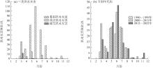
Fig. 8
Monthly distribution of flood disasters and monthly distribution of flood disasters in different decades in Ili River Basin"
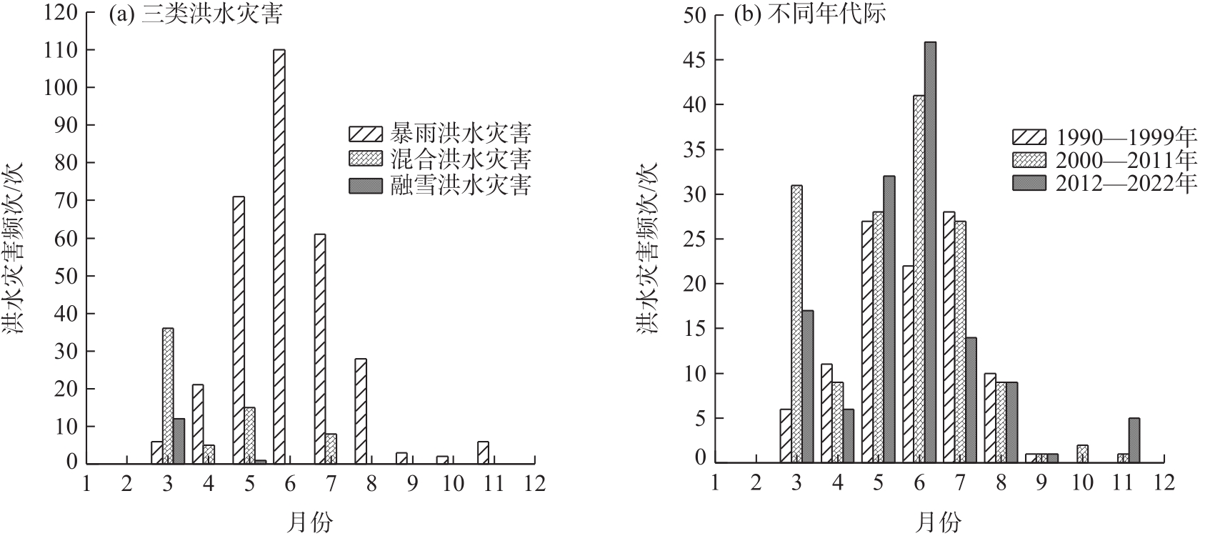
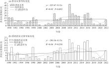
Fig. 9
Interannual variation of flood disaster frequency in Ili River Basin"

Tab. 5
"
| 灾害类型 | 1990—1999年 | 2000—2011年 | 2012—2022年 | 总计 |
|---|---|---|---|---|
| 暴雨 | 80 | 112 | 116 | 308 |
| 融雪 | 0 | 8 | 5 | 13 |
| 混合 | 25 | 29 | 10 | 64 |
| 总计 | 105 | 149 | 131 | 385 |
Tab. 6
Sensitivity evaluation index system of disaster-prone environment in Ili River Basin"
| 指标层 | 极低敏感 | 低敏感 | 中敏感 | 高敏感 | 极高敏感 | 权重 |
|---|---|---|---|---|---|---|
| 高程/m | <1500 | 1501~2000 | 2001~2500 | 2501~3000 | 3001~6231 | 0.28 |
| 坡度/(°) | <8 | 9~18 | 19~28 | 29~38 | 39~85 | 0.10 |
| 地表粗糙度/(°) | <1.04 | 1.05~1.21 | 1.22~1.48 | 1.49~1.93 | >1.94 | 0.05 |
| 水域缓冲区/km | >15 | 9~15 | 6~9 | 3~6 | <3 | 0.33 |
| NDVI | >0.8 | 0.6~0.8 | 0.4~0.6 | 0.2~0.4 | <0.2 | 0.11 |
| 土地利用类型 | 建设用地 | 林地 | 耕地、草地 | 未利用地 | 水域 | 0.13 |
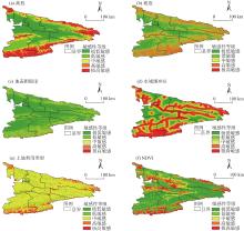
Fig. 10
Sensitivity analysis of disaster-prone environment factors"

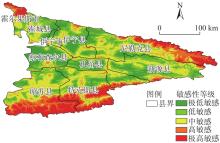
Fig. 11
Spatial distribution of sensitive comprehensive grade of disaster-prone environment in Ili River Basin"
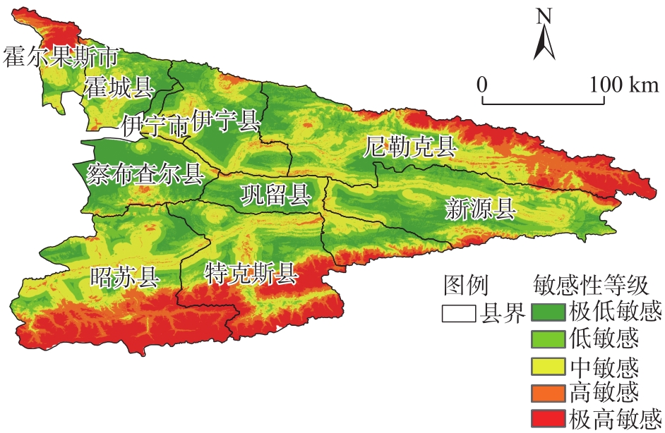
Tab. 7
Sensitivity comprehensive classification of disaster-prone environment"
| 敏感性分级 | 孕灾敏感指数分级 | 面积/km2 | 占比/% |
|---|---|---|---|
| 极低敏感 | 1.25~2.29 | 10384.70 | 19.33 |
| 低敏感 | 2.30~2.75 | 13550.31 | 25.22 |
| 中敏感 | 2.76~3.33 | 16513.23 | 30.73 |
| 高敏感 | 3.34~4.11 | 6041.02 | 11.24 |
| 极高敏感 | 4.12~4.93 | 7241.89 | 13.48 |
| [1] | 邱海军, 曹明明, 胡胜. 1950—2010年中国洪涝灾情的频率规模关系[J]. 自然灾害学报, 2013, 22(4): 114-119. |
| [Qiu Haijun, Cao Mingming, Hu Sheng. The relationship between the frequency and the scale of flood situation in China from 1950 to 2010[J]. Journal of Natural Disaster, 2013, 22(4): 114-119.] | |
| [2] |
胡畔, 陈波, 史培军. 中国暴雨洪涝灾情时空格局及影响因素[J]. 地理学报, 2021, 76(5): 1148-1162.
doi: 10.11821/dlxb202105008 |
|
[Hu Pan, Chen Bo, Shi Peijun. Spatiotemporal patterns and influencing factors of rainstorm-induced flood disasters in China[J]. Acta Geographica Sinica, 2021, 76(5): 1148-1162.]
doi: 10.11821/dlxb202105008 |
|
| [3] | 王静, 李娜, 王艳艳, 等. 洪水灾害影响人口和经济风险评估区划方法研究[J]. 中国水利, 2023(8): 16-19. |
| [Wang Jing, Li Na, Wang Yanyan, et al. Study on flood affected population and economic risk assessment and zoning method[J]. China Water Reseources, 2023(8): 16-19.] | |
| [4] |
尹卫霞, 余瀚, 崔淑娟, 等. 暴雨洪水灾害人口损失评估方法研究进展[J]. 地理科学进展, 2016, 35(2): 148-158.
doi: 10.18306/dlkxjz.2016.02.002 |
|
[Yin Weixia, Yu Han, Cui Shujuan, et al. Review on methods for estimating the loss of life induced by heavy rain and floods[J]. Progress in Geography, 2016, 35(2): 148-158.]
doi: 10.18306/dlkxjz.2016.02.002 |
|
| [5] | 王妮, 崔彩霞, 刘艳. 新疆暴雨洪涝灾害损失的时空特征及其影响因素[J]. 干旱区研究, 2020, 37(2): 325-330. |
| [Wang Ni, Cui Caixia, Liu Yan. Temporal-spatial characteristics and the influencing factors of rainstorm-flood disasters in Xinjiang[J]. Arid Zone Research, 2020, 37(2): 325-330.] | |
| [6] | 刘艳, 卢新玉, 郑奕, 等. 新疆与中亚融雪型洪水监测、预警调研及对策建议[J]. 气象科技进展, 2022, 12(2): 21-29. |
| [Liu Yan, Lu Xinyu, Zheng Yi, et al. Investigation and countermeasures on monitoring & early-warning of snowmelt flood in Xinjiang and Central Asia[J]. Advances in Meteorological Science and Technology, 2022, 12(2): 21-29.] | |
| [7] | 何冰晶, 刘耀龙, 张华明, 等. 中国灾害风险与贫困互相关效应的理论分析与实证研究[J]. 干旱区地理, 2022, 45(5): 1649-1658. |
| [He Bingjing, Liu Yaolong, Zhang Huaming, et al. Theoretical analysis and empirical study on the nexus of disaster risk and poverty in China[J]. Arid Land Geography, 2022, 45(5): 1649-1658.] | |
| [8] | 陈颖, 马禹. 新疆不同等级暴雨洪涝灾害的时空变化特征[J]. 干旱区地理, 2021, 44(6): 1515-1524. |
| [Chen Ying, Ma Yu. Spatial and temporal characteristics of flood and rainstorm disaster in Xinjiang[J]. Arid Land Geography, 2021, 44(6): 1515-1524.] | |
| [9] | 王伏村, 许东蓓, 张德玉, 等. 西北地区东部一次大暴雨天气过程的诊断分析[J]. 干旱区研究, 2014, 31(3): 452-462. |
| [Wang Fucun, Xu Dongbei, Zhang Deyu, et al. Diagnostic analysis on a rainstorm in the eastern part of northwest China[J]. Arid Zone Research, 2014, 31(3): 452-462.] | |
| [10] | 余其鹰, 胡彩虹, 白云岗, 等. 新疆洪水预报预警中融雪径流模型应用进展[J]. 干旱区地理, 2023, 46(12): 1951-1962. |
| [Yu Qiying, Hu Caihong, Bai Yungang, et al. Application of snowmelt runoff model in flood forecasting and warning in Xinjiang[J]. Arid Land Geography, 2023, 46(12): 1951-1962.] | |
| [11] | 张国威, 何文勤, 商思臣. 我国干旱区洪水灾害基本特征──以新疆为例[J]. 干旱区地理, 1998, 21(1): 40-48. |
| [Zhang Guowei, He Wenqin, Shang Sichen. Basic features of the flood disasters in arid land of China: Taking Xinjiang as example[J]. Arid Land Geography, 1998, 21(1): 40-48.] | |
| [12] | 王小亚, 马诺, 李海花, 等. 南疆暴雨洪涝灾害风险区划[J]. 沙漠与绿洲气象, 2022, 16(4): 72-78. |
| [Wang Xiaoya, Ma Nuo, Li Haihua, et al. Risk zoning of rainstorm and flood disasters in southern Xinjiang[J]. Desert and Oasis Meteorology, 2022, 16(4): 72-78.] | |
| [13] | 周刚, 崔曼仪, 李哲, 等. 新疆春季融雪洪水危险性动态评价研究[J]. 干旱区研究, 2021, 38(4): 950-960. |
| [Zhou Gang, Cui Manyi, Li Zhe, et al. Dynamic evaluation of the risk of the spring snowmelt flood in Xinjiang[J]. Arid Zone Research, 2021, 38(4): 950-960.] | |
| [14] | 方建, 李梦婕, 王静爱, 等. 全球暴雨洪水灾害风险评估与制图[J]. 自然灾害学报, 2015, 24(1): 1-8. |
| [Fang Jian, Li Mengjie, Wang Jing’ai, et al. Assessment and mapping of global fluvial flood risk[J]. Desert and Oasis Meteorology, 2015, 24(1): 1-8.] | |
| [15] | 张俊兰, 罗继, 王荣梅. 近20 a新疆升温融雪(冰)型洪水频次时空变化及大气环流型分析[J]. 干旱区研究, 2021, 38(2): 339-350. |
| [Zhang Junlan, Luo Ji, Wang Rongmei. Combined analysis of the spatiotemporal variations in snowmelt (ice) flood frequency in Xinjiang over 20 years and atmospheric circulation patterns[J]. Arid Zone Research, 2021, 38(2): 339-350.] | |
| [16] | 郑艳丽. 伊犁河谷察布查尔县洪水发生特征分析[J]. 地下水, 2020, 42(4): 184-185. |
| [Zheng Yanli. Analysis of flood occurrence characteristics in Qapqal County of Yili Valley[J]. Ground Water, 2020, 42(4): 184-185.] | |
| [17] | 罗湘. 伊宁县暴雨洪水发生特征及坡面减流减沙对策研究[D]. 乌鲁木齐: 新疆农业大学, 2019. |
| [Luo Xiang. Characteristics of rain storm flood and countermeasures for reduction hill slope runoff and sediment in Yining County[D]. Urumqi: Xinjiang Agricultural University, 2019.] | |
| [18] | 杨涛, 张晋茹, 杨莲梅, 等. 近60年新疆主要气象灾害变化特征及其防灾减灾对策建议[J]. 气象科技进展, 2022, 12(6): 129-134. |
| [Yang Tao, Zhang Jinru, Yang Lianmei, et al. The change characteristics of major meteorological disasters in Xinjiang in recent 60 years and the countermeasures for disaster prevention and mitigation[J]. Advances in Meteorological Science and Technology, 2022, 12(6): 129-134.] | |
| [19] |
杨青, 姚俊强, 赵勇, 等. 伊犁河流域水汽含量时空变化及其和降水量的关系[J]. 中国沙漠, 2013, 33(4): 1174-1183.
doi: 10.7522/j.issn.1000-694X.2013.00166 |
| [Yang Qing, Yao Junqiang, Zhao Yong, et al. Spatial-temproral variation of water vapor and its relationship with the preciptation in the Ili River Basin[J]. Journal of Desert Research, 2013, 33(4): 1174-1183.] | |
| [20] | 王颖慧, 丁建丽, 李晓航. 伊犁河流域土地利用/覆被变化对生态系统服务价值的影响——基于强度分析模型[J]. 生态学报, 2022, 42(8): 3106-3118. |
| [Wang Yinhui, Ding Jianli, Li Xiaohang. Impact of LUCC on ecosystem services values in the Yili River Basin based on an intensity analysis model[J]. Acta Ecologica Sinica, 2022, 42(8): 3106-3118.] | |
| [21] | 袁证光, 汪磊. 基于EM-AHP-TOPSIS的喀斯特城市土地承载力评价——以贵阳市为例[J/OL]. 自然资源情报, 1-7[2023-06-25]. http://kns.cnki.net/kcms/detail/10.1798.N.20230619.1417.008.html. |
| [Yuan Zhengguang, Wang Lei. Evaluation of land resources carrying capacity of karst cities based on EM-AHP-TOPSIS model: A case study of Guiyang[J/OL]. Natural Resources Information, 1-7[2023-06-25]. http://kns.cnki.net/kcms/detail/10.1798.N.20230619.1417.008.html.] | |
| [22] |
郭佳, 赵之星, 刘志奇, 等. 结合信息量与AHP模型的阳泉市矿区地质灾害风险评价[J]. 测绘通报, 2022(11): 101-105.
doi: 10.13474/j.cnki.11-2246.2022.0333 |
| [Guo Jia, Zhao Zhixing, Liu Zhiqi, et al. Risk assessment of geological disaster based on information value and AHP model in mining area of Yangquan City[J]. Surveying and Mapping Bulletin, 2022(11): 101-105.] | |
| [23] |
王秀琴, 王旭. 1980—2019年新疆南部不同强度暴雨洪水灾害的空间分布和时间变化特征[J]. 冰川冻土, 2021, 43(6): 1818-1828.
doi: 10.7522/j.issn.1000-0240.2021.0032 |
|
[Wang Xiuqin, Wang Xu. Spatial distribution and temporal variation characteristics of rainstorm flood disasters with different intensities in southern Xinjiang from 1980 to 2019[J]. Journal of Glaciology and Geocryology, 2021, 43(6): 1818-1828.]
doi: 10.7522/j.issn.1000-0240.2021.0032 |
|
| [24] | 刘仪航, 韩剑桥, 谢梦霞, 等. 基于GIS与AHP集成的黄土高原洪水灾害风险评估[J]. 水土保持研究, 2023, 30(2): 129-134. |
| [Liu Yihang, Han Jianqiao, Xie Mengyao, et al. Risk assessment of flood disaster on the Loess Plateau based on integration of GIS and AHP[J]. Research of Soil and Water Conservation, 2023, 30(2): 129-134.] | |
| [25] | 张紫昭, 张天栋, 于喜坤, 等. 新疆崩滑流地质灾害孕灾环境分区及其形成机制[J]. 工程地质学报, 2023, 31(4): 1129-1144. |
| [Zhang Zizhao, Zhang Tiandong, Yu Xikun, et al. Zonation of disaster environments of collapse, landslide and debris flow geologic hazards and their formation mechanisms in Xinjiang[J]. Journal of Engineering Geology, 2023, 31(4): 1129-1144.] | |
| [26] | 赵伟, 周娟, 陈科技, 等. 浙江电网台风风灾的孕灾环境因子敏感性分析[J]. 灾害学, 2022, 37(3): 118-121. |
| [Zhao Wei, Zhou Juan, Chen Keji, et al. Sensitivity analysis on hazard-pregnant environmental factors for wind disasters caused by typhoon in Zhejiang power grid[J]. Journal of Catastrophology, 2022, 37(3): 118-121.] | |
| [27] | 刘艳, 何清, 戴晓爱, 等. 新疆铁路沿线主要气象灾害风险区划及减灾对策探讨[J]. 自然灾害学报, 2016, 25(3): 48-57. |
| [Liu Yan, He Qing, Dai Xiaoai, et al. Risk mapping of main meteorological disasters and disaster mitigation strategies for Xinjiang railway lines[J]. Journal of Natural Disasters, 2016, 25(3): 48-57.] | |
| [28] | 邹凤钗, 陶小郎, 吕东, 等. 万山区地质灾害时空分布规律和孕灾环境研究[J]. 贵州科学, 2022, 40(5): 51-56, 86. |
| [Zou Fengchai, Tao Xiaolang, Lü Dong, et al. Spatial and tempoal distribution and hazard-formative environment of geologic hazards in Wanshan District[J]. Guizhou Science, 2022, 40(5): 51-56, 86.] | |
| [29] | 刘艳, 阮慧华, 何清. 新疆拟建铁路沿线雪风灾分区和致灾性分析[J]. 灾害学, 2012, 27(2): 54-57. |
| [Liu Yan, Ruan Huihua, He Qing. Snow and wind disaster zoning and catastrophability analysis of the planned railway in Xinjiang[J]. Journal of Catastrophology, 2012, 27(2): 54-57.] | |
| [30] | 周仿荣, 潘浩, 马仪, 等. 考虑地形地貌影响的云南省落雷孕灾环境敏感性分析[J]. 电网技术, 2022, 46(7): 2834-2841. |
| [Zhou Fangrong, Pan Hao, Ma Yi, et al. Sensitivity analysis on hazard-pregnant environment of lightning activity in Yunnan Province considering effects of topography[J]. Power System Technology, 2022, 46(7): 2834-2841.] | |
| [31] | 张晓东, 赵银鑫, 马风华, 等. 基于遥感数据的银川市城市公园对城市热环境降温效应分析[J]. 水土保持通报, 2021, 41(5): 338-347. |
| [Zhang Xiaodong, Zhao Yinxin, Ma Fenghua, et al. Analysis on cooling effect of urban parks on urban thermal environment in Yinchuan City based on remote sensing[J]. Power System Technology, 2021, 41(5): 338-347.] | |
| [32] | 邹桃红, 陈鹏, 刘家福, 等. 不同土地利用情景下四平市生态系统碳储量时空演变[J]. 中国环境科学, 2023, 43(10): 5508-5518. |
| [Zou Taohong, Chen Peng, Liu Jiafu, et al. Spatio-temporal dynamics of territorial ecosystem carbon storage under different land use scenarios in Siping City[J]. China Environmental Science, 2023, 43(10): 5508-5518.] | |
| [33] | 刘鑫, 赵鲁强, 刘娜, 等. 伊犁河流域春季融雪型洪水危险性评价与区划[J]. 气象科技进展, 2016, 6(6): 35-41. |
| [Liu Xin, Zhao Luqiang, Liu Na, et al. Risk evaluation of the spring snowmelt flood in Ili River Basin and its mapping[J]. Advances in Meteorological Science and Technology, 2016, 6(6): 35-41.] | |
| [34] | 熊平生, 刘亮, 郝丽. 洞庭湖区洪涝灾害成因及其孕灾环境的变化研究[J]. 安徽农学通报, 2021, 27(3): 141-143. |
| [Xiong Pingsheng, Liu Liang, Hao Li. Research on reasons of the flood disaster in Dongting Lake area and its environment change of flood disaster[J]. Anhui Agricultural Science Bulletin, 2021, 27(3): 141-143.] | |
| [35] | 殷洁, 裴志远, 陈曦炜, 等. 基于GIS的武陵山区洪水灾害风险评估[J]. 农业工程学报, 2013, 29(24): 110-117. |
| [Yin Jie, Pei Zhiyuan, Chen Xiwei, et al. GIS-based flood disaster risk assessment in Wuling Mountain region[J]. Transactions of the Chinese Society of Agricultural Engineering (Transactions of the CSAE), 2013, 29(24): 110-117.] |
| [1] | LI Yaqian, YANG Jianhua, XIA Haobin, WU Jianjun. Spatiotemporal variations of vegetation in the Ili River Basin from 2000 to 2022 [J]. Arid Land Geography, 2024, 47(5): 741-752. |
| [2] | CHENG Long, WU Bo, JIA Xiaohong, YIN Jie, FEI Bingqiang, ZHANG Lingguang, YUE Yanpeng, SUN Yingtao, LI Jia. Dynamic change of soil moisture and its response to rainfall during the growing season in Mu Us Sandy Land based on continuous observation data [J]. Arid Land Geography, 2024, 47(4): 648-661. |
| [3] | CAI Xia, LIANG Guihua, ZHANG Dongfeng, CAI Lin, BAI Ying, LI Ruifeng. Temporal and spatial evolution of extreme precipitation and its response to atmospheric circulation factors in northern Shanxi Province [J]. Arid Land Geography, 2024, 47(3): 391-402. |
| [4] | CHEN Man, CHEN Yaning, FANG Gonghuan, LI Yupeng, SUN Huilan. Changes in glacial lakes on the northern slope of Kunlun Mountains and assessment of their outburst risks [J]. Arid Land Geography, 2024, 47(10): 1628-1639. |
| [5] | ZHANG Jing, BAO Guangyu, LIU Wei, YANG Chunhua, YAN Zhenning, DAI Qingcuo, FU Yongchao. Characteristics and model of rainstorm and flood disaster risk index along Qinghai Highway [J]. Arid Land Geography, 2024, 47(1): 28-37. |
| [6] | LI Lele, CHAO Jinlong, ZHAO Deyi, LI Haojie, WU Lindong, LI Jiajun. Spatiotemporal distribution characteristics of rainstorm and risk assessment of rainstorm disasters in Shanxi Province from 1957 to 2019 [J]. Arid Land Geography, 2023, 46(5): 689-699. |
| [7] | WU Zhixiang, ZHANG Zhibin, ZHAO Xuewei, CHEN Long, MA Xiaomin, CHAI Jiao. Spatiotemporal distribution pattern and influencing factors of A-level tourist attractions in northwestern China [J]. Arid Land Geography, 2023, 46(12): 2061-2073. |
| [8] | ZHANG Xueqi,XIA Qianqian,CHEN Yaning,XIA Zhenhua,ZHU Chengang,LI Jinglong,HAO Haichao,XIANG Yanyun. Effects of ecological water conveyance on gross primary productivity of vegetation in Tarim River in recent 20 years [J]. Arid Land Geography, 2021, 44(3): 718-728. |
| [9] | CUI Yang, CHANG Zhuo-lin, ZUO He-jiang, WANG Jian-ying. Risk and impact zoning of different return period flash flood disasters in Yinchuan Section of Helan Mountain [J]. Arid Land Geography, 2020, 43(4): 859-870. |
| [10] |
XU Yu-xia, XU Xiao-ming, FANG Feng, HE Rui.
Assessment and zoning of vulnerability of agricultural flood diaster in Baoji City based on county scale [J]. Arid Land Geography, 2020, 43(3): 652-660. |
| [11] |
TIAN Ya-lin, LI Xue-mei, LI Zhen, QIN Qi-rui.
Spatial and temporal variations of different precipitation types in the Tianshan Mountains from 1980 to 2017 [J]. Arid Land Geography, 2020, 43(2): 308-318. |
| [12] | JIANG Meng-di, ZHANG Peng-li, LIANG Bo-yi, LI Yu. Relationship between the distribution of Neolithic cultural sites and topography in the Lanzhou Basin [J]. Arid Land Geography, 2020, 43(1): 27-37. |
| [13] | XU Yu-xia, XU Xiao-ming, MA Nan. Assessment and regionalization of flood disaster risk in Shaanxi Province at the county scale [J]. 干旱区地理, 2018, 41(2): 306-313. |
| [14] | LUAN Fu-ming, WANG Fang, XIONG Hei-gang. Spatio-temporal distribution of cultural sites and geographic backgrounds in the Ili River Valley [J]. , 2017, 40(1): 211-221. |
| [15] | YANG Ling,ZHA Xiaochun. Change law of drought and flood disasters in Qianhe Basin from 1470 to 2009 [J]. , 2012, 35(01): 133-138. |
|
||