Arid Land Geography ›› 2024, Vol. 47 ›› Issue (7): 1165-1174.doi: 10.12118/j.issn.1000-6060.2023.560
• Climatology and Hydrology • Previous Articles Next Articles
WU Mengyu1( ), LI Dongjie2, HAN Yuguo1,3(), QIU Ye1, QU Zhixu1
Received:2023-10-10
Revised:2023-11-15
Online:2024-07-25
Published:2024-07-30
Contact:
HAN Yuguo
E-mail:Wmy991030@bjfu.edu.cn;yghan@bjfu.edu.cn
WU Mengyu, LI Dongjie, HAN Yuguo, QIU Ye, QU Zhixu. Thresholds of irrigated farmland area in the Hexi Corridor region[J].Arid Land Geography, 2024, 47(7): 1165-1174.

Fig. 1
Schematic diagram of the study area"
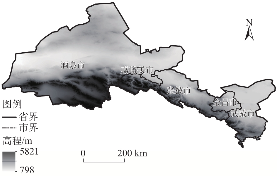
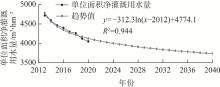
Fig. 2
Net irrigation water use per unit area and its trend analysis"
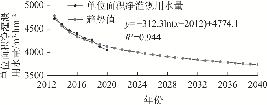
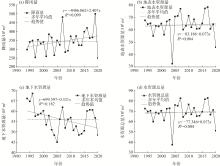
Fig. 3
Rainfall and water resources changes in the Hexi Corridor region from 1994 to 2020"
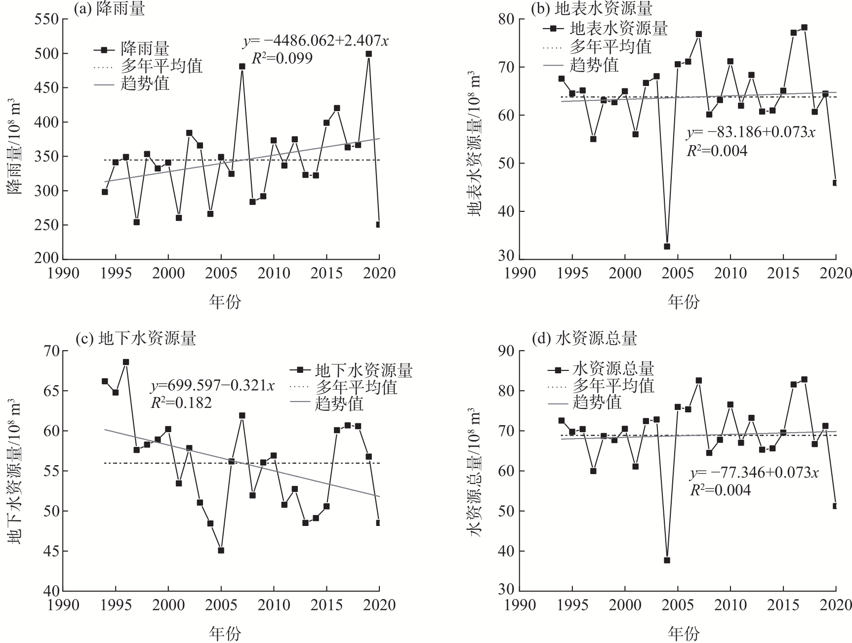
Fig. 4
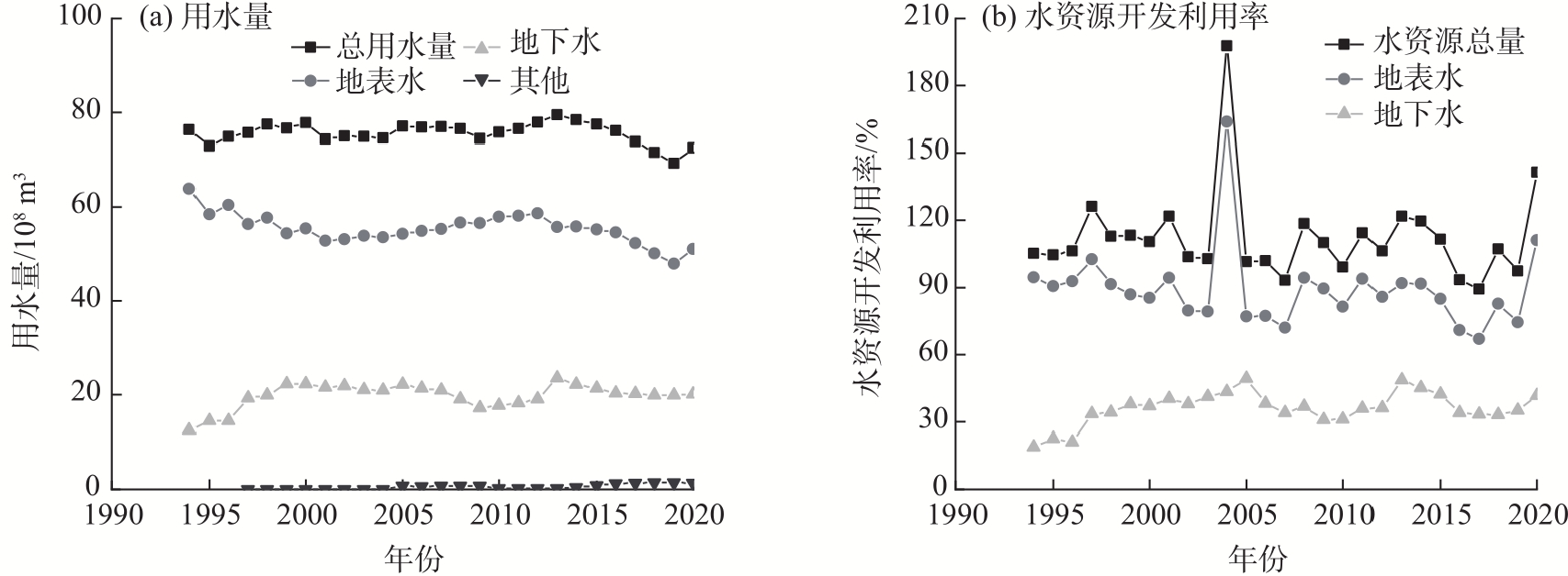
Status of water resources development and utilization in the Hexi Corridor region from 1994 to 2020"
Tab. 1
Changes in water use by sectors in the Hexi Corridor region /108 m³"
| 年份 | 农田灌溉用水量 | 林牧渔畜用水量 | 工业用水量 | 城镇公共用水量 | 居民生活用水量 | 生态环境用水量 | 总用水量 |
|---|---|---|---|---|---|---|---|
| 2001 | 63.56 | 5.02 | 4.22 | 0.39 | 1.17 | - | 74.36 |
| 2002 | 66.21 | 5.03 | 4.73 | 0.36 | 1.15 | - | 76.75 |
| 2003 | 64.14 | 5.33 | 3.78 | 0.35 | 1.19 | 0.08 | 74.88 |
| 2004 | 63.65 | 5.62 | 3.57 | 0.38 | 1.21 | 0.08 | 74.53 |
| 2005 | 64.33 | 3.81 | 3.93 | 0.39 | 1.94 | 2.74 | 77.13 |
| 2006 | 63.54 | 4.09 | 4.12 | 0.41 | 2.05 | 2.69 | 76.89 |
| 2007 | 64.78 | 4.51 | 3.62 | 0.44 | 2.05 | 1.65 | 77.03 |
| 2008 | 64.08 | 4.56 | 3.64 | 0.44 | 2.13 | 1.68 | 76.53 |
| 2009 | 62.27 | 4.88 | 3.80 | 0.46 | 1.39 | 1.70 | 74.48 |
| 2010 | 63.25 | 5.00 | 4.04 | 0.46 | 1.43 | 1.72 | 75.88 |
| 2011 | 63.14 | 4.63 | 4.36 | 0.44 | 1.43 | 1.69 | 76.58 |
| 2012 | 63.39 | 4.53 | 6.40 | 0.46 | 1.45 | 1.70 | 77.91 |
| 2013 | 65.69 | 5.80 | 5.12 | 0.73 | 1.10 | 1.07 | 79.52 |
| 2014 | 64.60 | 4.74 | 5.10 | 0.78 | 1.13 | 1.09 | 78.41 |
| 2015 | 63.30 | 5.67 | 4.71 | 0.74 | 1.14 | 1.91 | 77.47 |
| 2016 | 61.31 | 5.71 | 4.39 | 0.74 | 1.16 | 2.85 | 76.16 |
| 2017 | 59.29 | 5.84 | 3.30 | 0.79 | 1.15 | 3.45 | 73.82 |
| 2018 | 57.45 | 5.45 | 3.25 | 0.88 | 1.21 | 3.31 | 71.53 |
| 2019 | 55.86 | 5.58 | 3.06 | 0.68 | 1.22 | 2.88 | 69.27 |
| 2020 | 54.82 | 4.58 | 2.71 | 0.67 | 1.63 | 8.08 | 72.53 |
Tab. 2
Estimated water demand and available water for farmland irrigation in the Hexi Corridor region /108 m³"
| 用水情景 | 可利用水资源总量 | 林牧渔畜需水量 | 工业用水需水量 | 城镇公共需水量 | 居民生活需水量 | 农田灌溉可用水量 |
|---|---|---|---|---|---|---|
| 经济发展优先情景 | 48.22 | 4.58 | 2.71 | 0.67 | 1.63 | 38.63 |
| 生态发展优先情景 | 34.44 | 4.58 | 2.71 | 0.67 | 1.63 | 24.85 |
| 经济兼顾生态发展情景 | 41.33 | 4.58 | 2.71 | 0.67 | 1.63 | 31.74 |
Tab. 3
Stepwise regression analysis of effective utilization coefficient of irrigation water and related influence factors"
| 影响因子 | 参数估计 | t值 | P值 |
|---|---|---|---|
| 微灌占比 | 0.267 | 9.179 | 0.000** |
| 喷滴灌占比 | -0.192 | -1.860 | 0.088 |
| 低压管灌占比 | -0.644 | -1.357 | 0.200 |
| 其他节水占比 | 0.092 | 0.444 | 0.665 |
| 实际灌溉面积 | 0.225 | 1.086 | 0.299 |
Tab. 4
Back generation test of linear regression model of irrigation water effective utilization coefficient"
| 年份 | 灌溉水有效利用系数实际值 | 灌溉水有效利用系数预测值 | 相对误差/% |
|---|---|---|---|
| 2006 | 0.473 | 0.496 | 4.94 |
| 2007 | 0.486 | 0.499 | 2.65 |
| 2008 | 0.490 | 0.501 | 2.16 |
| 2009 | 0.499 | 0.503 | 0.89 |
| 2010 | 0.514 | 0.503 | -2.11 |
| 2011 | 0.518 | 0.507 | -2.12 |
| 2012 | 0.523 | 0.511 | -2.31 |
| 2013 | 0.531 | 0.515 | -3.01 |
| 2014 | 0.537 | 0.525 | -2.33 |
| 2015 | 0.541 | 0.539 | -0.29 |
| 2016 | 0.547 | 0.554 | 1.22 |
| 2017 | 0.553 | 0.556 | 0.45 |
| 2018 | 0.560 | 0.562 | 0.44 |
| 2019 | 0.565 | 0.568 | 0.50 |
| 2020 | 0.570 | 0.574 | 0.63 |
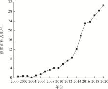
Fig. 5
Change in micro-irrigation area proportion from 2001 to 2020"

Tab. 5
Thresholds for carrying irrigated area in the Hexi Corridor region"
| 微灌占比情景 | 灌溉水有效利用系数 | 单位面积灌溉用水量/m3·hm-2 | 经济发展优先情景 | 生态发展优先情景 | 经济兼顾生态发展情景 | |||||
|---|---|---|---|---|---|---|---|---|---|---|
| 农田灌溉可用水量/108 m3 | 可承载灌溉面积阈值/104 hm2 | 农田灌溉可用水量/108 m3 | 可承载灌溉面积阈值/104 hm2 | 农田灌溉可用水量/108 m3 | 可承载灌溉面积阈值/104 hm2 | |||||
| 微灌占比30% | 0.572 | 6556 | 38.63 | 58.92 | 24.85 | 37.90 | 31.74 | 48.41 | ||
| 微灌占比45% | 0.612 | 6127 | 38.63 | 63.05 | 24.85 | 40.56 | 31.74 | 51.80 | ||
| 微灌占比60% | 0.652 | 5752 | 38.63 | 67.16 | 24.85 | 43.20 | 31.74 | 55.18 | ||
| [1] |
Puy A, Borgonovo E, Lo Piano S, et al. Irrigated areas drive irrigation water withdrawals[J]. Nature Communications, 2021, 12(1): 4525, doi: 10.1038/s41467-021-24508-8.
pmid: 34312386 |
| [2] | Zhu X F, Li Y Z, Li M Y, et al. Agricultural irrigation in China[J]. Journal of Soil and Water Conservation, 2013, 68(6): 147A-154A. |
| [3] | 李绵德, 周冬梅, 朱小燕, 等. 河西走廊2000—2020年农业碳排放时空特征及其影响因素[J]. 农业资源与环境学报, 2023, 40(4): 940-952. |
| [Li Miande, Zhou Dongmei, Zhu Xiaoyan, et al. Spatial-temporal characteristics of agricultural carbon emissions and influencing factors in the Hexi Corridor from 2000 to 2020[J]. Journal of Agriculture Resources and Environment, 2023, 40(4): 940-952.] | |
| [4] | 陈世超, 刘文丰, 杜太生. 基于水氮管理与种植结构优化的作物丰产高效管理策略[J]. 农业工程学报, 2022, 38(16): 144-152. |
| [Chen Shichao, Liu Wenfeng, Du Taisheng. Achieving high-yield and high-efficient management strategy based on optimized irrigation and nitrogen fertilization management and planting structure[J]. Journal of Agricultural Engineering, 2022, 38(16): 144-152.] | |
| [5] | 王利民. “一带一路”视角下的水资源短缺响应——以甘肃河西走廊绿洲为例[J]. 甘肃农业, 2017(6): 47-49. |
| [Wang Limin. Response to water scarcity under the perspective of “Belt and Road”: The case of Gansu Hexi Corridor oasis[J]. Gansu Agriculture, 2017(6): 47-49.] | |
| [6] | 李玉忠, 胡秉安. 河西绿洲灌溉农业区发展节水农业探析[J]. 中国农村水利水电, 2011(2): 55-58. |
| [Li Yuzhong, Hu Bing’an. Exploring the development of water-saving agriculture in the irrigated agricultural area of Hexi oasis[J]. China Rural Water Conservancy and Hydropower, 2011(2): 55-58.] | |
| [7] | Gao L M, Zhang Y N. Spatio-temporal variation of hydrological drought under climate change during the period 1960—2013 in the Hexi Corridor, China[J]. Journal of Arid Land, 2016, 8(2): 157-171. |
| [8] | 唐霞, 李森. 历史时期河西走廊绿洲演变研究的进展[J]. 干旱区资源与环境, 2021, 35(7): 48-55. |
| [Tang Xia, Li Sen. An analysis on the oasis evolution of Hexi Corridor in historical period[J]. Journal of Arid Land Resources and Environment, 2021, 35(7): 48-55.] | |
| [9] | 赵新风, 徐海量, 王敏, 等. 不同水平年塔里木河流域灌溉面积超载分析[J]. 农业工程学报, 2015, 31(24): 77-81. |
| [Zhao Xinfeng, Xu Hailiang, Wang Min, et al. Overloading analysis of irrigation area in basins of Tarim River in different years[J]. Journal of Agricultural Engineering, 2015, 31(24): 77-81.] | |
| [10] | 魏光辉, 桂东伟, 赵新风. 不同水平年塔里木河流域“四源一干”可承载灌溉面积研究[J]. 干旱区地理, 2018, 41(2): 230-237. |
| [Wei Guanghui, Gui Dongwei, Zhao Xinfeng. Irrigation area carrying capacity in Tarim River Basin in different years[J]. Arid Land Geography, 2018, 41(2): 230-237.] | |
| [11] | 张沛, 陈超群, 徐海量, 等. 塔里木河“九源一干”可承载最大灌溉面积探讨[J]. 干旱区研究, 2017, 34(1): 223-231. |
| [Zhang Pei, Chen Chaoqun, Xu Hailiang, et al. The bearable largest irrigation area in the basins of nine source streams and mainstream of the Tarim River[J]. Arid Zone Research, 2017, 34(1): 223-231.] | |
| [12] |
李婧昕, 张红旗. 新疆昌吉绿洲耕地适宜规模研究[J]. 地理研究, 2021, 40(3): 613-626.
doi: 10.11821/dlyj020200848 |
|
[Li Jingxin, Zhang Hongqi. Study on the suitable scale of cultivated land in oasis of Changji, Xinjiang[J]. Geographical Research, 2021, 40(3): 613-626.]
doi: 10.11821/dlyj020200848 |
|
| [13] | 柯映明. 近60年来渭干河流域耕地与胡杨的时空演变分析[D]. 北京: 中国科学院大学, 2020. |
| [Ke Yingming. Spatiotemporal evolution analysis of cropland and Populus euphratica in Weigan River Basin in recent 60 years[D]. Beijing: University of Chinese Academy of Sciences, 2020.] | |
| [14] | 陈志达. 甘肃省农田灌溉水有效利用系数测算分析研究——以2014年测算工作为例[J]. 甘肃农业, 2015(12): 32-34. |
| [Chen Zhida. Analytical study on measurement and analysis of effective utilization coefficient of agricultural irrigation water in Gansu Province: Taking the measurement work in 2014 as an example[J]. Gansu Agriculture, 2015(12): 32-34.] | |
| [15] | 张靖琳, 吉喜斌, 陈学亮, 等. 河西走廊中段临泽绿洲水资源供需平衡及承载力分析[J]. 干旱区地理, 2018, 41(1): 38-47. |
| [Zhang Jinglin, Ji Xibin, Chen Xueliang, et al. Regional supply-demand balance and carrying capacity of water resources for Linze oasis in the middle of Hexi Corridor[J]. Arid Land Geography, 2018, 41(1): 38-47.] | |
| [16] | 贾绍凤, 柳文华. 水资源开发利用率40%阈值溯源与思考[J]. 水资源保护, 2021, 37(1): 87-89. |
| [Jia Shaofeng, Liu Wenhua. Tracing and thinking about 40% threshold value of water resources development and utilization ratio[J]. Water Resources Protection, 2021, 37(1): 87-89.] | |
| [17] | 钱正英, 张光斗. 中国可持续发展水资源战略研究综合报告及各专题报告[M]. 北京: 水利水电出版社, 2001. |
| [Qian Zhengying, Zhang Guangdou. Synthesis report and thematic reports of the study on China’s water resources strategy for sustainable development[M]. Beijing: Water Resources and Hydropower Press, 2001.] | |
| [18] | 邱琳麟. 水资源约束下的塔里木河流域耕地适宜规模研究[D]. 上海: 华东师范大学, 2022. |
| [Qiu Linlin. Appropriate scale study of cultivated land in the Tarim River Basin with water resource constraints[D]. Shanghai: East China Normal University, 2020.] | |
| [19] | 郭丹丹, 张世伟, 吴劲, 等. 基于Horton分形的灌区灌溉水有效利用系数影响因素分析[J]. 北京师范大学学报(自然科学版), 2020, 56(3): 436-444. |
| [Guo Dandan, Zhang Shiwei, Wu Jin, et al. Factors influencing effective utilization coefficient of irrigation water as determined with Horton fractal[J]. Journal of Beijing Normal University (Natural Science Edition), 2020, 56(3): 436-444.] | |
| [20] | 鞠艳, 杨星, 毕克杰, 等. 江苏省农田灌溉水有效利用系数年际变化及其影响因素分析[J]. 灌溉排水学报, 2022, 41(12): 123-130. |
| [Ju Yan, Yang Xing, Bi Kejie, et al. Annual variation in effective utilization coefficient of irrigation water and its determinants in Jiangsu Province[J]. Journal of Irrigation and Drainage, 2022, 41(12): 123-130.] | |
| [21] |
王凌阁, 朱睿, 陈泽霞, 等. 甘肃河西地区2000—2019年水土资源耦合协调特征[J]. 中国沙漠, 2022, 42(2): 44-53.
doi: 10.7522/j.issn.1000-694X.2021.00108 |
|
[Wang Lingge, Zhu Rui, Chen Zexia, et al. Coupling effect of water-soil resources in Hexi area of Gansu, China in 2000—2019[J]. Journal of Desert Research, 2022, 42(2): 44-53.]
doi: 10.7522/j.issn.1000-694X.2021.00108 |
|
| [22] | 陈亚宁, 李忠勤, 徐建华, 等. 中国西北干旱区水资源与生态环境变化及保护建议[J]. 中国科学院院刊, 2023, 38(3): 385-393. |
| [Chen Yaning, Li Zhongqin, Xu Jianhua, et al. Changes and protection suggestions in water resources and ecological environment in arid region of northwest China[J]. Bulletin of Chinese Academy of Sciences, 2023, 38(3): 385-393.] | |
| [23] |
王澄海, 张晟宁, 张飞民, 等. 论全球变暖背景下中国西北地区降水增加问题[J]. 地球科学进展, 2021, 36(9): 980-989.
doi: 10.11867/j.issn.1001-8166.2021.087 |
|
[Wang Chenghai, Zhang Shengning, Zhang Feimin, et al. On the increase of precipitation in the northwestern China under the global warming[J]. Advances in Earth Science, 2021, 36(9): 980-989.]
doi: 10.11867/j.issn.1001-8166.2021.087 |
|
| [24] |
Huss M, Hock R. Global-scale hydrological response to future glacier mass loss[J]. Nature Climate Change, 2018, 8(2): 135-140.
doi: 10.1038/s41558-017-0049-x |
| [25] |
Zhao H Y, Su B, Lei H J, et al. A new projection for glacier mass and runoff changes over High Mountain Asia[J]. Science Bulletin, 2023, 68(1): 43-47.
doi: 10.1016/j.scib.2022.12.004 pmid: 36682858 |
| [26] | 王伟军, 赵雪雁, 张明军, 等. 西北干旱区内陆河流域公众的水资源感知及节水意向——以甘肃省河西走廊地区为例[J]. 中国人口·资源与环境, 2019, 29(11): 148-157. |
| [Wang Weijun, Zhao Xueyan, Zhang Mingjun, et al. Public perception of water resources and water-saving intention in arid inland river basins of northwestern China[J]. China Population, Resources and Environment, 2019, 29(11): 148-157.] | |
| [27] | 左其亭. 净水资源利用率的计算及阈值的讨论[J]. 水利学报, 2011, 42(11): 1372-1378. |
| [Zuo Qiting. Discussion on the calculation method and threshold of the net-utilization ratio of water resources[J]. Journal of Hydraulic Engineering, 2011, 42(11): 1372-1378.] | |
| [28] | 杨芳, 郑江丽, 李兴拼. 省级灌溉水有效利用系数测算工作评估方法探讨[J]. 节水灌溉, 2016(9): 129-132. |
| [Yang Fang, Zheng Jiangli, Li Xingpin. Exploration of assessment methods for measuring the effective utilization coefficient of irrigation water at the provincial level[J]. Water Saving Irrigation, 2016(9): 129-132.] | |
| [29] | 冯保清, 崔静. 全国纯井灌区类型构成对灌溉水有效利用系数的影响分析[J]. 灌溉排水学报, 2013, 32(3): 50-53. |
| [Feng Baoqing, Cui Jing. Influence analysis of irrigation area composition of well irrigation district on irrigation water use efficiency in China[J]. Journal of Irrigation and Drainage, 2013, 32(3): 50-53.] | |
| [30] |
邓铭江. 中国西北“水三线”空间格局与水资源配置方略[J]. 地理学报, 2018, 73(7): 1189-1203.
doi: 10.11821/dlxb201807001 |
| [Deng Mingjiang. “Three Water Lines” strategy: Its spatial patterns and effects on water resources allocation in northwest China[J]. Journal of Geography, 2018, 73(7): 1189-1203.] | |
| [31] | 杨静, 周冬梅, 马静, 等. 疏勒河流域农业水土资源时空匹配特征分析[J]. 干旱区地理, 2023, 46(6): 982-992. |
| [Yang Jing, Zhou Dongmei, Ma Jing, et al. Spatial and temporal matching characteristics of agricultural land and water resources in the Shule River Basin[J]. Arid Land Geography, 2023, 46(6): 982-992.] |
| [1] | BO Liming, YIN Li, WEI Wei, ZHAO Lang, XIA Junnan. Evolution characteristics and its driving mechanism of territorial spatial pattern in the Hexi Corridor from 2000 to 2020 [J]. Arid Land Geography, 2024, 47(5): 885-897. |
| [2] | MA Yali, NIU Zuirong, SUN Dongyuan. Relationship between changes in spatial and temporal patterns of potential evapotranspiration and meteorological factors in the Hexi Corridor [J]. Arid Land Geography, 2024, 47(2): 192-202. |
| [3] | YANG Rongmei, ZHOU Hong, ZHANG Yanni, LU Xunxian, WANG Nana. Tourism ecological security assessment in Hexi Corridor region based on entropy weight TOPSIS method and fuzzy matter-element model [J]. Arid Land Geography, 2024, 47(1): 117-126. |
| [4] | ZHANG Ning,WANG Zichen,YANG Xiao,CHEN Tong,XING Fei. Coupling coordination and spatiotemporal differences between water resources and agriculture cropping system in Xinjiang: A case of grain and cotton cropping systems [J]. Arid Land Geography, 2023, 46(3): 349-359. |
| [5] | YANG Xiaoling,LI Yanying,CHEN Jing,GUO Limei,CHEN Ying,ZHAO Huihua. Transmission of rare strong dust and its process continuous characteristics in Hexi Corridor [J]. Arid Land Geography, 2022, 45(5): 1415-1425. |
| [6] | LI Qi,LI Fadong,WANG Guoqin,QIAO Yunfeng,Rashid KULMATOV,PENG Yu,Sayidjakhon KHASANOV,LIU Hongguang,HE Xinlin,YANG Guang. Development of irrigated agriculture in Uzbekistan and its impact on ecological environment and economic development [J]. Arid Land Geography, 2021, 44(6): 1810-1820. |
| [7] | YANG Mei,LI Yanying,ZHANG Chunyan,YANG Jiping,LUO Xiaoling,NIE Xin. Variation characteristics of spring sandstorm and its typical case analysis in the middle east of Hexi Corridor [J]. Arid Land Geography, 2021, 44(5): 1339-1349. |
| [8] | LIU Xia,ZHANG Man,XU Jianhua,GUO Ying,DUAN Weili,SHEN Yanjun. Water resources carrying capacity of Tarim River Basin based on system dynamics model [J]. Arid Land Geography, 2021, 44(5): 1407-1416. |
| [9] | LYU Qing-song, XIN Cun-lin, WANG Rui, ZHANG Bo, ZHANG Hua. Frequency and influencing factors of spring cold wave in Hexi Corridor from 1966 to 2018 [J]. Arid Land Geography, 2020, 43(4): 946-954. |
| [10] |
HAN Qun-zhu, FENG Qi, GAO Hai-dong, CHEN Gui-ping.
Influencing factors of agricultural production changes in Guanzhong based on PCA [J]. Arid Land Geography, 2020, 43(2): 474-480. |
| [11] | ZHOU Liang, ZHU Yan-ru, SUN Dong-qi. Spatial differentiation characteristics and oasis breed degree of urban and rural residents in Hexi Corridor [J]. Arid Land Geography, 2020, 43(1): 227-236. |
| [12] | XIONG Yuan-kang, ZHANG Qing-ling. Cropping structure extraction with [WTHX]NDVI[WTHZ] timeseries images in the northern Tianshan Economic Belt [J]. Arid Land Geography, 2019, 42(5): 1105-1114. |
| [13] | ZHANG Lian-wei, LANG Jie, LI Li. Historical evolution of sandy desertification in ancient China [J]. 干旱区地理, 2018, 41(6): 1270-1277. |
| [14] | ZHANG Jing-lin, JI Xi-bin, CHEN Xue-liang, XU Shi-qin, JIAO Dan-dan. Regional supply-demand balance and carrying capacity of water resources for Linze Oasis in the middle of Hexi Corridor [J]. 干旱区地理, 2018, 41(1): 38-47. |
| [15] | DING Wen-kui, YANG Xiao-ling, WANG Zuo-cheng, YUE Ping. Variation characteristics of low temperature Events in East of Hexi Corridor [J]. 干旱区地理, 2018, 41(1): 17-24. |
|
||