- Aug. 1, 2025
Arid Land Geography ›› 2023, Vol. 46 ›› Issue (2): 243-252.doi: 10.12118/j.issn.1000-6060.2022.270
• Climate and Environment Change • Previous Articles Next Articles
WANG Zichao1( ),WANG Chunlei2(),MA Junjun1
Received:2022-06-07
Revised:2022-09-14
Online:2023-02-25
Published:2023-03-14
WANG Zichao, WANG Chunlei, MA Junjun. Estimation of downward surface longwave radiation in Heihe River Basin with remotely sensed data[J].Arid Land Geography, 2023, 46(2): 243-252.

Fig. 1
Distribution map of study area and sites"
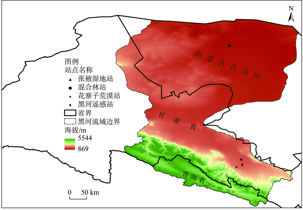
Tab. 1
Basic information of meteorological stations"
| 气象站 | 经纬度 | 海拔高度/m | 下垫面类型 | 四分量辐射仪位置 |
|---|---|---|---|---|
| 花寨子荒漠站 | 100.3201°E,38.7659°N | 1731 | 山前荒漠 | 6 m处,朝向正南 |
| 混合林站 | 100.1335°E,41.9903°N | 874 | 怪柳与胡杨 | 24 m处,朝向正南 |
| 黑河遥感站 | 100.4765°E,38.8270°N | 1560 | 人工草地 | 1.5 m处,朝向正南 |
| 张掖湿地站 | 100.4464°E,38.9751°N | 1460 | 芦苇湿地 | 6 m处,朝向正南 |
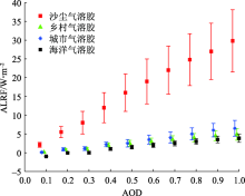
Fig. 2
Average ALRF and STD of four different aerosol types varies with the AOD"
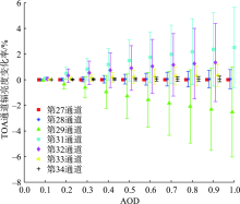
Fig. 3
TOA channel radiance change rate and STD of different AOD conditions under dust aerosol conditions"

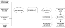
Fig. 4
Flow chart of DSLR inversion by using the improved model"

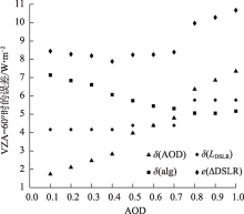
Fig. 5
Errors under different AOD cases when VZA=60°"
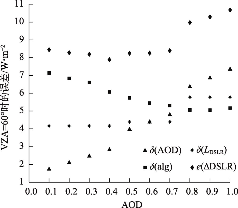
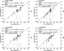
Fig. 6
Scatter plots of DSLR inversion values and measured values of the two models under the condition of dust aerosol"


Fig. 7
Scatter plots of DSLR inversion error and AOD for two models under dust aerosol conditions"
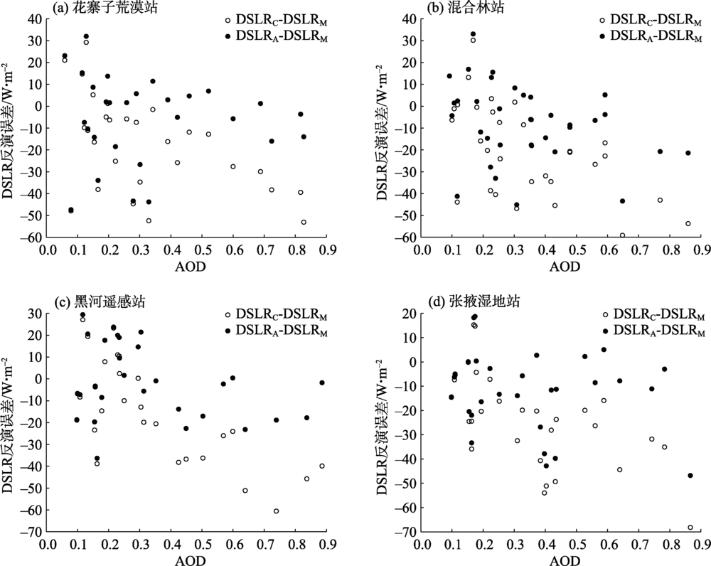
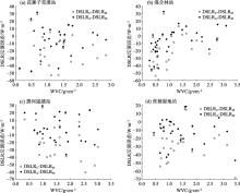
Fig. 8
Scatter plots of DSLR inversion error and WVC for two models under dust aerosol conditions"

| [1] | Alexandri G, Georgoulias A K, Zanis P, et al. On the ability of RegCM4 regional climate model to simulate surface solar radiation patterns over Europe: An assessment using satellite-based observations[J]. Atmospheric Chemistry and Physics, 2015, 15(22): 13195-13216. |
| [2] | Mateos D, Anton M, Toledano C, et al. Aerosol radiative effects in the ultraviolet, visible, and near-infrared spectral ranges using long-term aerosol data series over the Iberian Peninsula[J]. Atmospheric Chemistry and Physics, 2014, 14(24): 13497-13514. |
| [3] |
Guo Y M, Cheng J, Liang S L. Comprehensive assessment of parameterization methods for estimating clear-sky surface downward longwave radiation[J]. Theoretical and Applied Climatology, 2019, 135(3): 1045-1058.
doi: 10.1007/s00704-018-2423-7 |
| [4] |
Iziomon M G, Mayer H, Matzarakis A. Downward atmospheric longwave irradiance under clear and cloudy skies: Measurement and parameterization[J]. Journal of Atmospheric and Solar-Terrestrial Physics, 2003, 65(10): 1107-1116.
doi: 10.1016/j.jastp.2003.07.007 |
| [5] |
Brutsaert W. On a derivable formula for long-wave radiation from clear skies[J]. Water Resources Research, 1975, 11(5): 742-744.
doi: 10.1029/WR011i005p00742 |
| [6] | 闵敏, 吴晓. 从FY-4A卫星遥感数据和GFS资料估算全天空状况下的地表长波辐射通量[J]. 气象, 2020, 46(3): 336-345. |
| [Min Min, Wu Xiao. Estimating surface longwave radiation flux under all-sky condition from FY-4A and GFS data[J]. Meteorological Monthly, 2020, 46(3): 336-345.] | |
| [7] | 李建江, 李佳, 吴立新, 等. 基于高亚洲精细再分析数据模拟普若岗日冰原2012—2014年表面能量-物质平衡[J]. 干旱区研究, 2021, 38(4): 919-929. |
| [Li Jianjiang, Li Jia, Wu Lixin, et al. Simulating surface energy and mass balance of the Puruogangri ice cap during 2012—2014 based on High Asia Refined analysis data[J]. Arid Zone Research, 2021, 38(4): 919-929.] | |
| [8] |
Bisht G, Venturini V, Islam S, et al. Estimation of the net radiation using MODIS (Moderate Resolution Imaging Spectroradiometer) data for clear sky days[J]. Remote Sensing of Environment, 2005, 97(1): 52-67.
doi: 10.1016/j.rse.2005.03.014 |
| [9] |
Tang B H, Li Z L. Estimation of instantaneous net surface longwave radiation from MODIS cloudfree data[J]. Remote Sensing of Environment, 2008, 112(9): 3482-3492.
doi: 10.1016/j.rse.2008.04.004 |
| [10] |
Wang W H, Liang S L. Estimation of high-spatial resolution clear-sky longwave downward and net radiation over land surfaces from MODIS data[J]. Remote Sensing of Environment, 2009, 113(4): 745-754.
doi: 10.1016/j.rse.2008.12.004 |
| [11] | Ridley D A, Heald C L, Kok J F, et al. An observationally constrained estimate of global dust aerosol optical depth[J]. Atmospheric Chemistry and Physics, 2016, 16(23): 15097-15117. |
| [12] | 茹建波, 王天河, 李积明, 等. 东亚沙尘源区晴空和云上沙尘气溶胶特征[J]. 中国沙漠, 2018, 38(2): 372-383. |
| [Ru Jianbo, Wang Tianhe, Li Jiming, et al. Characteristics of dust aerosol in both clear-sky and above-cloud conditions over East Asia[J]. Journal of Desert Research, 2018, 38(2): 372-383.] | |
| [13] | 谢艳清, 李正强, 侯伟真. FY-4A AGRI陆地气溶胶光学厚度反演[J]. 遥感学报, 2022, 26(5): 913-922. |
| [Xie Yanqing, Li Zhengqiang, Hou Weizhen. Aerosol optical depth retrieval over land using data from AGRI onboard FY-4A[J]. Journal of Remote Sensing, 2022, 26(5): 913-922.] | |
| [14] | 贾臣, 孙林, 陈允芳, 等. 深度置信网络算法反演Landsat 8 OLI气溶胶光学厚度[J]. 遥感学报, 2020, 24(10): 1180-1192. |
| [Jia Chen, Sun Lin, Chen Yunfang, et al. Inversion of aerosol optical depth for Landsat 8 OLI data using deep belief network[J]. Journal of Remote Sensing, 2020, 24(10): 1180-1192.] | |
| [15] | 王联霞, 张衡, 徐青. VIIRS高分辨率地表反射率关系库支持下的气溶胶光学厚度反演[J]. 测绘科学技术学报, 2021, 38(3): 295-300. |
| [Wang Lianxia, Zhang Heng, Xu Qing. VIIRS aerosol optical depth retrieval based on high resolution surface reflectance ratio database[J]. Journal of Geomatics Science and Technology, 2021, 38(3): 295-300.] | |
| [16] | 李丁, 秦凯, 薛勇, 等. 基于S5P/TROPOMI的中国东部气溶胶单次散射反照率反演初探[J]. 遥感学报, 2022, 26(5): 897-912. |
| [Li Ding, Qin Kai, Xue Yong, et al. Preliminary retrieval of aerosol single scattering albedo in eastern China based on S5P/TROPOMI[J]. Journal of Remote Sensing, 2022, 26(5): 897-912.] | |
| [17] |
Xin J, Gong C, Wang S, et al. Aerosol direct radiative forcing in desert and semi-desert regions of northwestern China[J]. Atmospheric Research, 2016, 171: 56-65.
doi: 10.1016/j.atmosres.2015.12.004 |
| [18] | 田磊, 张武, 常倬林, 等. 河西走廊干旱区春季沙尘气溶胶对辐射的影响初步研究[J]. 干旱区地理, 2018, 41(5): 923-929. |
| [Tian Lei, Zhang Wu, Chang Zhuolin, et al. Influence of spring dust aerosol on radiation over the arid area in Hexi Corridor[J]. Arid Land Geography, 2018, 41(5): 923-929.] | |
| [19] | Sicard M, Bertolín S, Mallet M, et al. Estimation of mineral dust long-wave radiative forcing: Sensitivity study to particle properties and application to real cases in the region of Barcelona[J]. Atmospheric Chemistry and Physics, 2014, 14(17): 9213-9231. |
| [20] |
Song L, Bian Z, Kustas W P, et al. Estimation of surface heat fluxes using multi-angular observations of radiative surface temperature[J]. Remote Sensing of Environment, 2020, 239: 111674, doi: 10.1016/j.rse.2020.111674.
doi: 10.1016/j.rse.2020.111674 |
| [21] |
Che T, Li X, Liu S, et al. Integrated hydrometeorological, snow and frozen-ground observations in the alpine region of the Heihe River Basin, China[J]. Earth System Science Data, 2019, 11(3): 1483-1499.
doi: 10.5194/essd-11-1483-2019 |
| [22] |
Hess M, Koepke P, Schult I. Optical properties of aerosols and clouds: The software package OPAC[J]. Bulletin of the American Meteorological Society, 1998, 79(5): 831-844.
doi: 10.1175/1520-0477(1998)079<0831:OPOAAC>2.0.CO;2 |
| [23] | 孙晓雷, 甘伟, 林燕, 等. MODIS 3 km气溶胶光学厚度产品检验及其环境空气质量指示[J]. 环境科学学报, 2015, 35(6): 1657-1666. |
| [Sun Xiaolei, Gan Wei, Lin Yan, et al. Validation of MODIS 3 km aerosol optical depth product and its air quality indication[J]. Acta Scientiae Circumstantiae, 2015, 35(6): 1657-1666.] | |
| [24] | Liu S M, Li X, Xu Z W, et al. The Heihe integrated observatory network: A basin-scale and surface processes observatory in China[J]. Vadose Zone Journal, 2018, 17(1): 1-21. |
| [25] |
Remer L A, Kaufman Y J, Tanré D, et al. The MODIS aerosol algorithm, products, and validation[J]. Journal of the Atmospheric Sciences, 2005, 62(4): 947-973.
doi: 10.1175/JAS3385.1 |
| [26] |
Sobrino J A, El Kharraz J, Li Z L. Surface temperature and water vapour retrieval from MODIS data[J]. International Journal of Remote Sensing, 2003, 24(24): 5161-5182.
doi: 10.1080/0143116031000102502 |
| [27] |
Jiao Z H, Mu X H. Global validation of clear-sky models for retrieving land-surface downward long-wave radiation from MODIS data[J]. Remote Sensing of Environment, 2022, 271: 112903, doi: 10.1016/j.rse.2022.112903.
doi: 10.1016/j.rse.2022.112903 |
| [28] | 韩超信, 汤耀国, 韩永翔, 等. 中国北方地区尘卷风时空分布的数值模拟[J]. 干旱区地理, 2021, 44(4): 1003-1010. |
| [Han Chaoxin, Tang Yaoguo, Han Yongxiang, et al. Simulation of spatial-temporal distribution of dust devil in northern China[J]. Arid Land Geography, 2021, 44(4): 1003-1010.] |
| [1] | YIN Yidan, YU Tengfei, HAN Tuo, TAN Tianyi, CHEN Xiaoling. Spatial differentiation and its influencing factors of soil carbon in Populus euphratica Oliv. forest in the lower reach of Heihe River [J]. Arid Land Geography, 2025, 48(1): 94-104. |
| [2] | KANG Limin, TENG Xinru, CHE Jiahang, HUAI Baojuan. Spatiotemporal variations of snow cover on the northern slope of Kunlun Mountains [J]. Arid Land Geography, 2024, 47(9): 1462-1471. |
| [3] | LI Yaqian, YANG Jianhua, XIA Haobin, WU Jianjun. Spatiotemporal variations of vegetation in the Ili River Basin from 2000 to 2022 [J]. Arid Land Geography, 2024, 47(5): 741-752. |
| [4] | ZHAO Mingjie, WANG Ninglian, SHI Chenlie, HOU Jingqi. Temporal and spatial variations of lake ice phenology in large lakes of Central Asia from 2000 to 2020 [J]. Arid Land Geography, 2024, 47(4): 561-575. |
| [5] | Aierken TUERSUN,Yusufujiang RUSULI,CUI Yishuang,Kadiayi ALIMU,Miriayi MAITUDI. Temporal and spatial variations of lake ice phenology in large lakes of Xinjiang from 2000 to 2019 [J]. Arid Land Geography, 2022, 45(5): 1440-1449. |
| [6] | PEI Xiaolong,GAO Tiansheng,ZHU Xiaosong,HAN Xiaolong. Construction of comprehensive observation network of natural resource elements in Heihe River Basin based on integration of space-air-ground [J]. Arid Land Geography, 2022, 45(5): 1450-1459. |
| [7] | LIANG Pengfei,XIN Huijuan,LI Zongxing,ZHANG Baijuan,GUI Juan,DUAN Ran,NAN Fusen,DINGZENG Yangping,YANG Shengmei. Runoff variation characteristics and influencing factors in the Heihe River Basin in the Qilian Mountains [J]. Arid Land Geography, 2022, 45(5): 1460-1471. |
| [8] | WANG Jinjie,DING Jianli,ZHANG Zipeng. Change of ecological environment in Turpan and Hami cities based on remote sensing ecology index [J]. Arid Land Geography, 2022, 45(5): 1591-1603. |
| [9] | YU Zhixiang,LI Xia,YU Xiaojing,ZHENG Yu,Manlen AYITKEN,LI Shuting,WANG Nan. Spatiotemporal variation characteristics of aerosol optical depth in Xinjiang from 2003 to 2019 [J]. Arid Land Geography, 2022, 45(2): 346-358. |
| [10] | QIN Qiyong,LI Xuemei,ZHANG Bo,LI Chao,SUN Tianyao. Change of ice phenology in the Sayram Lake from 2000 to 2019 [J]. Arid Land Geography, 2022, 45(1): 37-45. |
| [11] | WANG Liping,DUAN Sibo,ZHANG Xiaoyu,YU Yanru. Spatio-temporal distribution and variation characteristics of annual maximum land surface temperature in China during 2003-2018 [J]. Arid Land Geography, 2021, 44(5): 1299-1308. |
| [12] | HAN Chaoxin,TANG Yaoguo,HAN Yongxiang,LI Jiaxin,GUO Jianmao. Simulation of spatial-temporal distribution of dust devil in northern China [J]. Arid Land Geography, 2021, 44(4): 1003-1010. |
| [13] | LI Hui-rong. Estimation of snow depth based on reflectance and bright temperature in Xilin Gol League [J]. Arid Land Geography, 2020, 43(6): 1567-1572. |
| [14] | PANG Ran, WANG Wen. Analysis of vegetation index changes and the influence of hydrothermal combination in the Turpan Basin from 2001 to 2017 based on MODIS Data [J]. Arid Land Geography, 2020, 43(5): 1242-1252. |
| [15] |
HUANG Xin, LIU Jian-hong, SHEN Ke-jian, LIU Yong-mei, WANG Lei.
Grassland yield change in Qinghai Province based on MODIS data [J]. Arid Land Geography, 2020, 43(3): 715-725. |
| Viewed | ||||||||||||||||||||||||||||||||||||||||||||||||||
|
Full text 940
|
|
|||||||||||||||||||||||||||||||||||||||||||||||||
|
Abstract 335
|
|
|||||||||||||||||||||||||||||||||||||||||||||||||
Cited |
|
|||||||||||||||||||||||||||||||||||||||||||||||||
| Shared | ||||||||||||||||||||||||||||||||||||||||||||||||||
|
||