- Jul. 28, 2025
Arid Land Geography ›› 2021, Vol. 44 ›› Issue (6): 1665-1675.doi: 10.12118/j.issn.1000–6060.2021.06.15
• Earth Surface Process • Previous Articles Next Articles
GU Wei1,2( ),Guli JIAPAER1,3,4(),YIN Hanmin1,4,JIANG Liangliang1,4,ZANG Xiaofang1,5
Received:2020-08-28
Revised:2021-06-18
Online:2021-11-25
Published:2021-12-03
Contact:
JIAPAER Guli
E-mail:1758715191@qq.com;glmr@ms.xjb.ac.cn
GU Wei,Guli JIAPAER,YIN Hanmin,JIANG Liangliang,ZANG Xiaofang. Spatial and temporal distribution characteristic and division research of solar energy resources in southern Xinjiang[J].Arid Land Geography, 2021, 44(6): 1665-1675.
Tab. 1
Comparison of annual total solar radiation between reanalysis data set and radiation stations"
| 站点 | 年均太阳总辐射/MJ·m-2 | 误差/MJ·m-2 | 相对误差/% | 相关系数 | |
|---|---|---|---|---|---|
| 辐射站 | 再分析数据集 | ||||
| 焉耆 | 5870.41 | 5905.69 | 35.28 | 0.006 | 0.963** |
| 阿克苏 | 5615.95 | 5646.37 | 29.42 | 0.005 | 0.882* |
| 喀什 | 6089.24 | 6125.68 | 36.44 | 0.006 | 0.893* |
| 若羌 | 5769.71 | 5786.45 | 16.74 | 0.003 | 0.942** |
| 和田 | 5807.70 | 5837.31 | 29.61 | 0.005 | 0.912* |
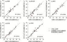
Fig. 1
Comparison of daily total solar radiation data between ITPCAS and radiation stations"

Tab. 2
Classification of solar energy resources change trend"
| 变化速率/%·a-1 | Hurst指数 | 太阳能资源变化趋势 |
|---|---|---|
| >10.0 | >0.5 | 持续且明显增加 |
| 0.9~10.0 | >0.5 | 持续且轻微增加 |
| >0.9 | <0.5 | 反持续且从减少到增加 |
| -0.9~0.9 | - | 稳定 |
| <-0.9 | <0.5 | 反持续且从增加到减少 |
| -3.0~-0.9 | >0.5 | 持续且轻微减少 |
| <-3.0 | >0.5 | 持续且明显减少 |
Tab. 3
Index system of solar energy resource zoning classification"
| 级别 | 内涵 | 分级指标 |
|---|---|---|
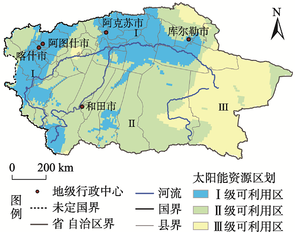
| Ⅰ级可利用区 | 指有良好的太阳能资源禀赋基础,沙尘天气、人口、交通基础设施等影响太阳能资源开发的条件较好,能够使太阳能资源实现规模化开发的地区。 | 将太阳能资源丰富、稳定、利用价值较高且具有持续增加趋势,沙尘天气较少、人口相对较多且陆路交通可达性良好的可开发区域判别为Ⅰ级可利用区。 |
| Ⅱ级可利用区 | 指有一定太阳能资源禀赋基础,沙尘天气、人口、交通基础设施等影响太阳能资源开发的条件一般,能够实现大规模农产品生长发育的地区。 | 将太阳能资源丰富、稳定、利用价值高且具有持续增加趋势,沙尘天气多、人口较少且基础交通设施一般的可开发区域判别为Ⅱ级可利用区。 |
| Ⅲ级可利用区 | 指有太阳能资源禀赋基础,但地处自然保护区且沙尘天气、人口、交通基础设施等影响太阳能资源开发的条件较差,使太阳能资源实现规模化开发受到较大约束的地区。 | 剔除Ⅰ级可利用区和Ⅱ级可利用区后,剩余地区判别为Ⅲ级可利用区。 |
Tab. 4
Classification of solar energy resource richness"
| 年太阳总辐射/MJ·m-2 | 丰富度 |
|---|---|
| <3780 | 一般 |
| 3780~5040 | 丰富 |
| 5040~6300 | 很丰富 |
| >6300 | 极丰富 |
Tab. 5
Classification of solar energy resource stability"
| 太阳能资源稳定度指标(K) | 稳定度 |
|---|---|
| <2 | 稳定 |
| 2~4 | 较稳定 |
| >4 | 不稳定 |
Tab. 6
Classification of solar energy resource utilization value"
| 各月日照时数大于6 h天数/d | 利用期 |
|---|---|
| <240 | 长 |
| 240~280 | 很长 |
| >280 | 极长 |
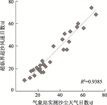
Fig. 2
Comparison of the days of supercritical sand velocity and the measured dust weather days in meteorological stations"

Tab. 7
Classification of sand-dust weather frequency"
| 沙尘天气频次/d | 等级 |
|---|---|
| <30 | 一般 |
| 30~45 | 较高 |
| >45 | 高 |
Fig. 3
Assessment results of other evaluation indicators in southern Xinjiang during 1980—2015"
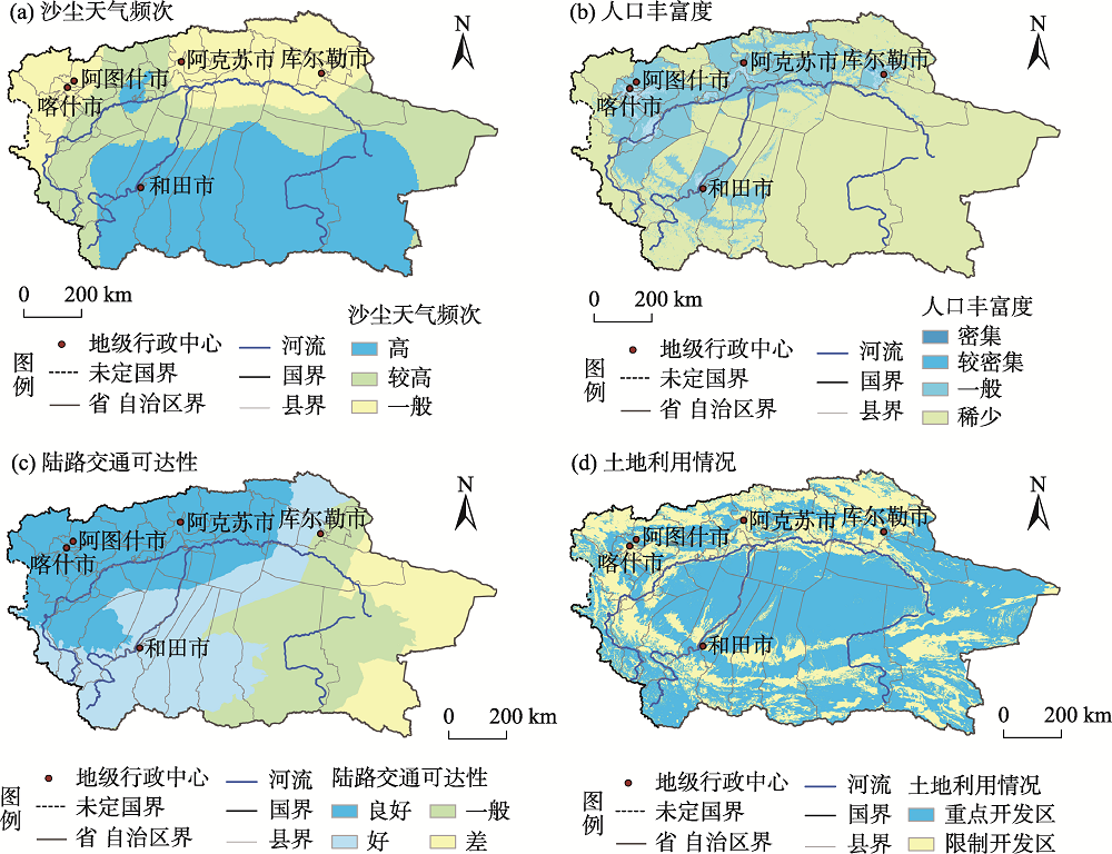
Tab. 8
Classification of population richness"
| 人口密度/人·km-2 | 人口丰富度 |
|---|---|
| 8~20 | 稀少 |
| 20~100 | 一般 |
| 100~1000 | 较密集 |
| >1000 | 密集 |
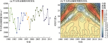
Fig. 4
Variation trend of total solar radiation during 1980—2015"

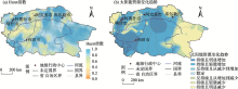
Fig. 5
Spatial distributions of Hurst index of total solar radiation and variation trend of solar energy resources in southern Xinjiang"

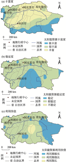
Fig. 6
Evaluation of solar energy resources in southern Xinjiang during 1980—2015"


Fig. 7
Solar energy resources utilization regionalization in southern Xinjiang"
| [1] | 刘佳, 何清, 刘蕊, 等. 新疆太阳辐射特征及其太阳能资源状况[J]. 干旱气象, 2008, 26(4):61-66. |
| [ Liu Jia, He Qing, Liu Rui, et al. Solar radiation character and solar energy resource in Xinjiang[J]. Journal of Arid Meteorology, 2008, 26(4):61-66. ] | |
| [2] | 左大康, 王勃贤, 陈建绥. 中国地区太阳总辐射的空间分布特征[J]. 气象学报, 1963, 33(1):78-96. |
| [ Zuo Dakang, Wang Boxian, Chen Jiansui. Characteristics of the distribution of total radiation in China[J]. Acta Meteorologica Sinica, 1963, 33(1):78-96. ] | |
| [3] | 马金玉, 罗勇, 梁宏, 等. 中国近半个世纪地面太阳总辐射时空变化特征[J]. 自然资源学报, 2012, 27(2):268-280. |
| [ Ma Jinyu, Luo Yong, Liang Hong, et al. Spatial and temporal variation of total solar radiation in China in recent 50 years[J]. Journal of Natural Resources, 2012, 27(2):268-280. ] | |
| [4] | 黄家敏, 杨洪海, 陈勇航, 等. 基于GEWEX-SRB资料的新疆地区太阳辐射时空分布特征[J]. 太阳能学报, 2017, 38(2):516-523. |
| [ Huang Jiamin, Yang Honghai, Chen Yonghang, et al. Spatial and temporal distribution of solar radiation in Xinjiang area based on GEWEX-SRB data[J]. Acta Energiae Solaris Sinica, 2017, 38(2):516-523. ] | |
| [5] | 吴林荣, 杜莉丽, 王娟敏, 等. 陕北榆林地区太阳能资源空间分布特征及资源潜力评估[J]. 水土保持通报, 2013, 33(1):238-242. |
| [ Wu Linrong, Du Lili, Wang Juanmin, et al. Distribution charateristics and evaluation of potential solar energy resources in Yulin region of northern Shaanxi Province[J]. Bulletin of Soil and Water Conservation, 2013, 33(1):238-242. ] | |
| [6] |
Stanhill G, Moreshet S. Global radiation climate changes: The world network[J]. Climatic Change, 1992, 21(1):57-75.
doi: 10.1007/BF00143253 |
| [7] | Stanhill G, Cohen S. Recent changes in solar irradiance in Antarctica[J]. Climate, 1997, 10:2078-2086. |
| [8] |
Stanhill G. Estimation of direct solar beam irradiance from measurements of the duration of bright sunshine[J]. International Journal of Climatology, 1998, 18(3):347-354.
doi: 10.1002/(ISSN)1097-0088 |
| [9] | 周扬, 吴文祥, 胡莹, 等. 西北地区太阳能资源空间分布特征及资源潜力评估[J]. 自然资源学报, 2010, 25(10):1738-1749. |
| [ Zhou Yang, Wu Wenxiang, Hu Ying, et al. The temporal-spatial distribution and evaluation of potential solar energy resources in northwest China[J]. Journal of Natural Resources, 2010, 25(10):1738-1749. ] | |
| [10] | 高庆先, 任阵海, 李占青, 等. 中国北方沙尘气溶胶时空分布特征及其对地表辐射的影响[J]. 资源科学, 2004, 26(5):2-10. |
| [ Gao Qingxian, Ren Zhenhai, Li Zhanqing, et al. Spatial and temporal distribution of dust aerosol and its impacts on radiation based on analysis of EP/TOMS satellite data[J]. Resources Science, 2004, 26(5):2-10. ] | |
| [11] | 陈春美, 钟珂, 陈勇航, 等. 干旱区典型城市云对太阳辐射的影响[J]. 干旱区研究, 2018, 35(2):436-443. |
| [ Chen Chunmei, Zhong Ke, Chen Yonghang, et al. Effects of clouds on solar radiation over typical city in arid area[J]. Arid Zone Research, 2018, 35(2):436-443. ] | |
| [12] | 姬兴杰, 贾志军, 肖国杰. 近60年郑州市地面太阳辐射变化的影响因素分析[J]. 太阳能学报, 2017, 38(5):1211-1219. |
| [ Ji Xingjie, Jia Zhijun, Xiao Guojie. Analysis of influence factors of surface solar radiation in Zhengzhou City over recent 60 years[J]. Acta Energiae Solaris Sinica, 2017, 38(5):1211-1219. ] | |
| [13] | 刘羽, 张显峰, 吕扬. 基于风云卫星数据的新疆太阳能资源潜力评价方法研究[J]. 太阳能学报, 2014, 35(7):1295-1303. |
| [ Liu Yu, Zhang Xianfeng, Lü Yang. Solar energy potential mapping and assessment in Xinjiang (China) based on the FY satellite data[J]. Acta Energiae Solaris Sinica, 2014, 35(7):1295-1303. ] | |
| [14] | 何杰, 阳坤. 中国区域高时空分辨率地面气象要素驱动数据集[DB/OL]. 寒区旱区科学数据中心, 2011. |
| [ He Jie, Yang Kun. China meteorological forcing dataset[DB/OL]. Cold and Arid Regions Science Data Center at Lanzhou, 2011. ] | |
| [15] |
Chen Y Y, Yang K, He J, et al. Improving land surface temperature modeling for dry land of China[J]. Journal of Geophysical Research: Atmospheres, 2011, 116(D20):D20104, doi: 10.1029/2011JD015921.
doi: 10.1029/2011JD015921 |
| [16] | 罗敏, 古丽·加帕尔, 郭浩, 等. 2000—2013年塔里木河流域生长季NDVI时空变化特征及其影响因素分析[J]. 自然资源学报, 2017, 32(1):50-63. |
| [ Luo Min, Jiapaer Guli, Guo Hao, et al. Spatial-temporal variation of growing-season NDVI and its responses to hydrothermal condition in the Tarim River Basin from 2000 to 2013[J]. Journal of Natural Resources, 2017, 32(1):50-63. ] | |
| [17] | 李芳. 张掖市植被覆盖动态变化及其与气象因子的关系[D]. 兰州: 甘肃农业大学, 2011. |
| [ Li Fang. Dynamic analysis of vegetation cover and relationships with climate factors in Zhangye region[D]. Lanzhou: Gansu Agricultural University, 2011. ] | |
| [18] | 陈彦光. 地理数学方法: 基础和应用[M]. 北京: 科学出版社, 2011: 463-473. |
| [ Chen Yanguang. Mathematical methods for geography: Foundations and applications[M]. Beijing: Science Press, 2011: 463-473. ] | |
| [19] | 魏凤英. 现代气候统计诊断与预测技术[M]. 北京: 气象出版社, 2007. |
| [ Wei Fengying. Statistics diagnosis and prediction of modern climate[M]. Beijing: Meteorological Press, 2007. ] | |
| [20] | 马金玉, 罗勇, 申彦波, 等. 近50年中国太阳总辐射长期变化趋势[J]. 中国科学: 地球科学, 2012, 42(10):1597-1608. |
| [ Ma Jinyu, Luo Yong, Shen Yanbo, et al. Regional long-term trend of ground solar radiation in China over the past 50 years[J]. Scientia Sinica (Terrae), 2012, 42(10):1597-1608. ] | |
| [21] | 章毅之, 王怀清, 胡菊芳. QX/T89–2008. 太阳能资源评估方法[S]. 中华人民共和国气象行业标准, 2008. |
| [ Zhang Yizhi, Wang Huaiqing, Hu Jufang. QX/T89-2008. Solar energy resource assessment method[S]. People’s Republic of China Meteorological Industry Standard, 2008. ] | |
| [22] | 王森, 王雪姣, 陈东东, 等. 1961—2017年南疆地区沙尘天气的时空变化特征及影响因素分析[J]. 干旱区资源与环境, 2019, 33(9):81-86. |
| [ Wang Sen, Wang Xuejiao, Chen Dongdong, et al. The spatial and temporal variation characteristics and influencing factors of dust weather in the southern Xinjiang from 1961 to 2017[J]. Journal of Arid Land Resources and Environment, 2019, 33(9):81-86. ] | |
| [23] | 周成龙 买买提艾力·买买提依明 杨兴华, 等. 基于模式参数化方案的塔中地区临界起沙阈值分析[J]. 干旱区地理, 2018, 41(5):930-936. |
| [ Zhou Chenglong, Mamtimin Ali, Yang Xinghua, et al. Critical threshold velocity of dust emission in Tazhong area based on the parameterization schemes[J]. Arid Land Geography, 2018, 41(5):930-936. ] | |
| [24] | Bagnold. The physics of blown sand and desert dunes[M]. London: Methuen, 1941. |
| [25] | 刘海隆, 包安明, 陈曦, 等. 新疆交通可达性对区域经济的影响分析[J]. 地理学报, 2008, 63(4):428-436. |
| [ Liu Hailong, Bao Anming, Chen Xi, et al. The effect of transport accessibility on regional economic performance[J]. Acta Geographica Sinica, 2008, 63(4):428-436. ] | |
| [26] |
Wild M, Gilgen H, Roesch A, et al. From dimming to brightening: Decadal changes in solar radiation at Earth’s surface[J]. Science, 2005, 308(5723):847-850.
doi: 10.1126/science.1103215 |
| [27] |
Tang B H, Li Z L, Zhang R H. A direct method for estimating net surface shortwave radiation from MODIS data[J]. Remote Sensing of Environment, 2006, 103(1):115-126.
doi: 10.1016/j.rse.2006.04.008 |
| [28] | 许建明, 何金海, 阎凤霞. 1961—2007年西北地区地面太阳辐射长期变化特征研究[J]. 气候与环境研究, 2010, 15(1):89-96. |
| [ Xu Jianming, He Jinhai, Yan Fengxia. Research on secular variation of solar radiation over northwest China from 1961 to 2007[J]. Climatic and Environmental Research, 2010, 15(1):89-96. ] | |
| [29] |
Jiang L L, Jiapaer Guli, Bao A M, et al. Monitoring the long-term desertification process and assessing the relative roles of its drivers in Central Asia[J]. Ecological Indicators, 2019, 104:195-208.
doi: 10.1016/j.ecolind.2019.04.067 |
| [30] | 彭艳, 王钊, 李星敏, 等. 近50 a西安太阳辐射变化特征及相关影响因子分析[J]. 干旱区地理, 2012, 35(5):738-745. |
| [ Peng Yan, Wang Zhao, Li Xingmin, et al. Variation characteristics of solar radiation and its impact factors of Xi’an in recent 50 years[J]. Arid Land Geography, 2012, 35(5):738-745. ] | |
| [31] | 冯刚, 李卫华, 韩宇, 等. 新疆太阳能资源及区划[J]. 可再生能源, 2010, 28(3):133-139. |
| [ Feng Gang, Li Weihua, Han Yu, et al. The solar energy resources of Xinjiang and its distribution[J]. Renewable Energy Resources, 2010, 28(3):133-139. ] | |
| [32] | 颜亮东, 周秉荣, 李晓东, 等. 三江源地区太阳能资源区划及利用潜力研究[J]. 资源科学, 2012, 34(11):2057-2066. |
| [ Yan Liangdong, Zhou Bingrong, Li Xiaodong, et al. The utilization potential and division of solar energy resources across “Three-River-Source”[J]. Resources Science, 2012, 34(11):2057-2066. ] | |
| [33] | 龚强, 于华深, 蔺娜, 等. 辽宁省风能、太阳能资源时空分布特征及其初步区划[J]. 资源科学, 2008, 30(5):654-661. |
| [ Gong Qiang, Yu Huashen, Lin Na, et al. Temporal-spatial distribution and regionalization of wind and solar energy resources in Liaoning Province[J]. Resources Science, 2008, 30(5):654-661. ] | |
| [34] | 王丽平, 段四波, 张霄羽, 等. 2003—2018年中国地表温度年最大值的时空分布及变化特征[J]. 干旱区地理, 2021, 44(5):1299-1308. |
| [ Wang Lipin, Duan Sibo, Zhang Xiaoyu, et al. Spatio-temporal distribution and variation characteristics of annual maximum land surface temperature in China during 2003—2018[J]. Arid Land Geography, 2021, 44(5):1299-1308. ] | |
| [35] | 张玉韩, 侯华丽, 沈悦, 等. 乌蒙山片区矿产资源开发功能分区及扶贫政探索[J]. 资源科学, 2018, 40(9):1716-1729. |
| [ Zhang Yuhan, Hou Huali, Shen Yue, et al. Study on the functional division of mineral resources development and poverty alleviation policy in Wumeng Mountain Area[J]. Resources Science, 2018, 40(9):1716-1729. ] | |
| [36] | 王勇, 赵战成, 晏军, 等. 新疆雪灾的时空分布特征及其等级划分[J]. 干旱区地理, 2020, 43(3):577-583. |
| [ Wang Yong, Zhao Zhancheng, Yan Jun, et al. Spatial and temporal distribution characteristics and its classification of snow disaster in Xinjiang[J]. Arid Land Geography, 2020, 43(3):577-583. ] |
| Viewed | ||||||||||||||||||||||||||||||||||||||||||||||||||
|
Full text 669
|
|
|||||||||||||||||||||||||||||||||||||||||||||||||
|
Abstract 718
|
|
|||||||||||||||||||||||||||||||||||||||||||||||||
Cited |
|
|||||||||||||||||||||||||||||||||||||||||||||||||
| Shared | ||||||||||||||||||||||||||||||||||||||||||||||||||
|
||