Arid Land Geography ›› 2021, Vol. 44 ›› Issue (3): 670-680.doi: 10.12118/j.issn.1000–6060.2021.03.09
• Ecology and Environment of Tarim River Basin • Previous Articles Next Articles
WANG Wanrui1,2( ),Aikeremu Abula3,CHEN Yaning1(),ZHU Chenggang1,CHEN Yapeng1
Received:2021-02-07
Revised:2021-03-25
Online:2021-05-25
Published:2021-06-01
Contact:
Yaning CHEN
E-mail:wangwanrui18@mails.ucas.ac.cn;chenyn@ms.xjb.ac.cn
WANG Wanrui,Aikeremu Abula,CHEN Yaning,ZHU Chenggang,CHEN Yapeng. Groundwater recharge during ecological water conveyance in the lower reaches of Tarim River[J].Arid Land Geography, 2021, 44(3): 670-680.

Fig. 1
Sketch map of the study area"
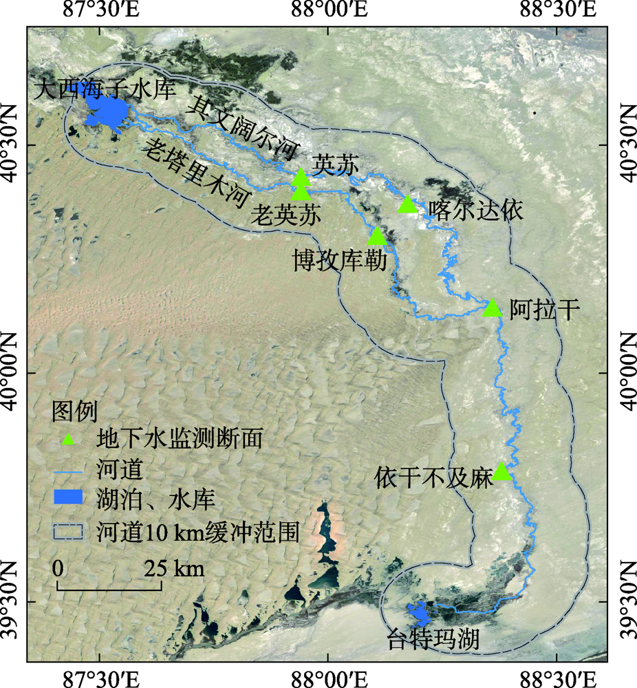

Fig. 2
Schematic diagram of groundwater recharge per unit channel length calculation"

Tab. 1
Variations of groundwater depth at the four monitoring sections in the lower reaches of Tarim River from 1973 to 2020 /m"
| 监测断面 | 1973年 | 1989年 | 1997年 | 2000年 | 2005年 | 2010年 | 2015年 | 2020年 |
|---|---|---|---|---|---|---|---|---|
| 英苏 | 5.44 | 8.00 | 9.40 | 7.27 | 5.05 | 6.79 | 7.84 | 4.26 |
| 喀尔达依 | 5.86 | 10.00 | 11.13 | 8.46 | 6.58 | 7.28 | 6.11 | 5.59 |
| 阿拉干 | 7.00 | 10.40 | 12.65 | 10.47 | 5.98 | 8.47 | 7.41 | 4.72 |
| 依干不及麻 | 6.20 | 12.75 | 12.92 | - | 5.62 | 7.07 | - | 4.11 |
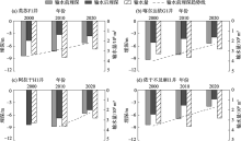
Fig. 3
Groundwater depth at the typical monitoring sections pre- and post-conveyance of water in the lower reaches of Tarim River in 2000, 2010 and 2020"

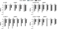
Fig. 4
Average annual groundwater depth at the four monitoring sections in the lower reaches of Tarim River in 2000, 2010 and 2020"
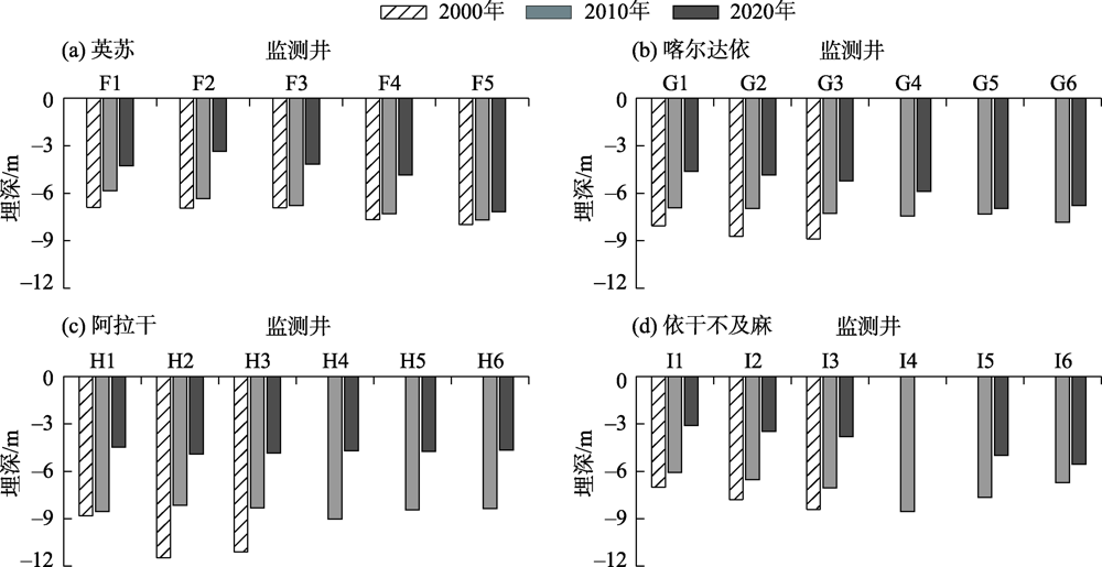
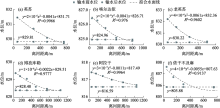
Fig. 5
Variations of groundwater level at the six monitoring sections pre- and post-conveyance of water in the lower reaches of Tarim River in 2020"
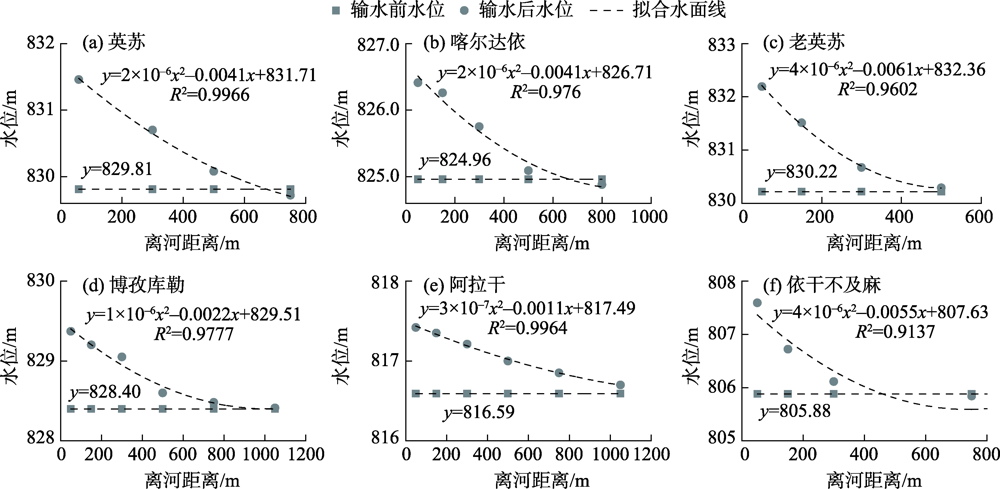
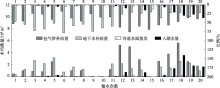
Fig. 6
Water equilibrium amount and its total proportion for the 21 times ecological water conveyances in the lower reaches of Tarim River"
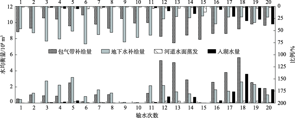
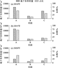
Fig. 7
Groundwater recharge and its total proportion at different district in the lower reaches of Tarim River from 2010 to 2020"

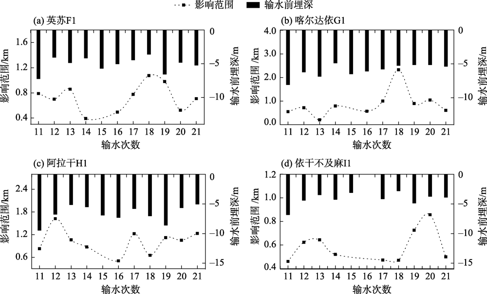
Fig. 8
The maximum influence range of groundwater during water conveyance at the four monitoring sections in the lower reaches of Tarim River from 2010 to 2020"
| [1] | 陈亚宁, 李卫红, 陈亚鹏, 等. 科技支撑新疆塔里木河流域生态修复及可持续管理[J]. 干旱区地理, 2018,41(5):901-907. |
| [ Chen Yaning, Li Weihong, Chen Yapeng, et al. Science in supporting the ecological restoration and sustainable development of the Tarim River Basin[J]. Arid Land Geography, 2018,41(5):901-907. ] | |
| [2] |
Huang T M, Pang Z H. Changes in groundwater induced by water diversion in the lower Tarim River, Xinjiang Uygur, NW China: Evidence from environmental isotopes and water chemistry[J]. Journal of Hydrology, 2010,387(3):188-201.
doi: 10.1016/j.jhydrol.2010.04.007 |
| [3] | 赵俊红, 周华荣, 卢雅焱, 等. 2000—2015年塔里木胡杨林国家级自然保护区NPP时空动态特征及其影响因素[J]. 干旱区地理, 2020,43(1):190-200. |
| [ Zhao Junhong, Zhou Huarong, Lu Yayan, et al. Temporal-spatial characteristics and influencing factors of the vegetation net primary production in the National Nature Reserve of Populus euphratica in Tarim from 2000 to 2015[J]. Arid Land Geography, 2020,43(1):190-200. ] | |
| [4] | 邓铭江, 周海鹰, 徐海量, 等. 塔里木河下游生态输水与生态调度研究[J]. 中国科学: 技术科学, 2016,46(8):864-876. |
| [ Deng Mingjiang, Zhou Haiying, Xu Hailiang, et al. Research on the ecological operation in the lower reaches of Tarim River based on water conveyance[J]. Scientia Sinica Technologica, 2016,46(8):864-876. ] | |
| [5] | 唐敏, 张峰, 师庆东. 克里雅河尾闾绿洲浅层地下水位埋深变化特征研究[J]. 干旱区地理, 2021,44(1):80-88. |
| [ Tang Min, Zhang Feng, Shi Qingdong. Characteristic variations in the groundwater table depth of the Daliyaboyi Oasis, Keriya River, China[J]. Arid Land Geography, 2021,44(1):80-88. ] | |
| [6] | 张经天, 席海洋. 荒漠河岸林地下水位时空动态及其对地表径流的响应[J]. 干旱区地理, 2020,43(2):388-397. |
| [ Zhang Jingtian, Xi Haiyang. Spatiotemporal dynamics of groundwater levels in a desert riparian forest and its response to surface runoff[J]. Arid Land Geography, 2020,43(2):388-397. ] | |
| [7] |
Ling H B, Guo B, Yan J J, et al. Enhancing the positive effects of ecological water conservancy engineering on desert riparian forest growth in an arid basin[J]. Ecological Indicators, 2020,118:106797, doi: 10.1016/j.ecolind.2020.106797.
doi: 10.1016/j.ecolind.2020.106797 |
| [8] |
Chen Y N, Wang Q, Li W H, et al. Rational groundwater table indicated by the eco-physiological parameters of the vegetation: A case study of ecological restoration in the lower reaches of the Tarim River[J]. Chinese Science Bulletin, 2006,51(1):8-15.
doi: 10.1007/s11434-006-8202-3 |
| [9] |
Ling H B, Xu H L, Guo B, et al. Regulating water disturbance for mitigating drought stress to conserve and restore a desert riparian forest ecosystem[J]. Journal of Hydrology, 2019,572:659-670.
doi: 10.1016/j.jhydrol.2019.03.049 |
| [10] | 陈亚宁, 陈亚鹏, 朱成刚, 等. 西北干旱荒漠区生态系统可持续管理理念与模式[J]. 生态学报, 2019,39(20):7410-7417. |
| [ Chen Yaning, Chen Yapeng, Zhu Chenggang, et al. The concept and mode of ecosystem sustainable management in arid desert areas in northwest China[J]. Acta Ecologica Sinica, 2019,39(20):7410-7417. ] | |
| [11] | 杨鹏年, 董新光, 吾买尔江. 塔里木河下游第五次应急输水后地下水恢复量的计算[J]. 自然资源学报, 2005,20(1):1-6. |
| [ Yang Pengnian, Dong Xinguang, Omerjan. Calculation of groundwater recharge volume after the fifth emergency water transfer to the lower reaches of the Tarim River, Xinjiang[J]. Journal of Natural Resources, 2005,20(1):1-6. ] | |
| [12] | 古力米热·哈那提, 张音, 关东海, 等. 生态输水条件下塔里木河下游断面尺度地下水流数值模拟[J]. 水科学进展, 2020,31(1):61-70. |
| [ Gulimire Hanati, Zhang Yin, Guan Donghai, et al. Numerical simulation of groundwater flow at cross-section scale in the lower reaches of Tarim River under the condition of ecological water conveyance[J]. Advances in Water Science, 2020,31(1):61-70. ] | |
| [13] |
Chen Y N, Zhang X L, Zhang Y M, et al. Analysis on the ecological benefits of the stream water conveyance to the dried-up river of the lower reaches of the Tarim River[J]. Sci China Ser D-Earth Sci, 2004,47:1053-1064.
doi: 10.1360/03yd0101 |
| [14] | 李丽君, 张小清, 陈长清, 等. 近20 a塔里木河下游输水对生态环境的影响[J]. 干旱区地理, 2018,41(2):238-247. |
| [ Li Lijun, Zhang Xiaoqing, Chen Changqing, et al. Ecological effects of water conveyance on the lower reaches of Tarim River in recent twenty years[J]. Arid Land Geography, 2018,41(2):238-247. ] | |
| [15] | 邓铭江, 杨鹏年, 周海鹰, 等. 塔里木河下游水量转化特征及其生态输水策略[J]. 干旱区研究, 2017,34(4):717-726. |
| [ Deng Mingjiang, Yang Pengnian, Zhou Haiying, et al. Water conversion and strategy of ecological water conveyance in the lower reaches of the Tarim River[J]. Arid Zone Research, 2017,34(4):717-726. ] | |
| [16] | 湾疆辉, 陈亚宁, 李卫红, 等. 断流河道输水对地下水净补给量研究——以塔里木河下游为例[J]. 中国沙漠, 2009,29(2):376-382. |
| [ Wan Jianghui, Chen Yaning, Li Weihong, et al. Study on net groundwater recharge after ecological water conveyance in the lower reaches of Tarim River[J]. Journal of Desert Research, 2009,29(2):376-382. ] | |
| [17] | 杨鹏年, 邓铭江, 李霞, 等. 塔里木河下游间歇输水下地下水响应宽度—以塔里木河下游英苏断面为例[J]. 干旱区研究, 2008,25(3):331-335. |
| [ Yang Pengnian, Deng Mingjiang, Li xia, et al. Respond width of groundwater level after conveying stream water to the lower reaches of the Tarim River, Xinjiang: A case study along the Yengisu Section in the lower reaches of Tarim River[J]. Arid Zone Research, 2008,25(3):331-335. ] | |
| [18] | 宋郁东, 樊自立, 雷志栋, 等. 中国塔里木河水资源与生态问题研究[M]. 乌鲁木齐: 新疆人民出版社, 2000: 50-160. |
| [ Song Yudong, Fan Zili, Lei Zhidong, et al. Research on water resources and ecology of Tarim River[M]. Urumqi: Xinjiang People’s Press, 2000: 50-160. ] | |
| [19] | 王大纯, 张人权, 史毅虹, 等. 水文地质学基础[M]. 北京: 地质出版社, 1995. |
| [ Wang Dachun, Zhang Renquan, Shi Yihong, et al. Hydrogeology basis[M]. Beijing: Beijing Geology Press, 1995. ] | |
| [20] | 新疆地矿局第一勘察院. 塔里木河干流流域水文地质及地下水开发利用调查[R]. 乌鲁木齐: 新疆地矿局第一勘察院, 1990. |
| [ The First Reconnaissance Institute of Xinjiang Geologic and Mineral Bureau. Investigation on hydrogeology and groundwater exploitation along the mainstream of Tarim River[R]. Urumqi: The First Reconnaissance Institute of Xinjiang Geologic and Mineral Bureau, 1990. ] | |
| [21] |
Xi H Y, Feng Q, Zhang L, et al. Groundwater storage changes and estimation of stream lateral seepage to groundwater in desert riparian forest region[J]. Hydrology Research, 2018,49(3):861-877.
doi: 10.2166/nh.2017.279 |
| [22] | 陈亚宁, 郝兴明, 陈亚鹏, 等. 新疆塔里木河流域水系连通与生态保护对策研究[J]. 中国科学院院刊, 2019,34(10):1156-1164. |
| [ Chen Yaning, Hao Xingming, Chen Yapeng, et al. Study on water system connectivity and ecological protection countermeasures of Tarim River Basin in Xinjiang[J]. Bulletin of Chinese Academy of Sciences, 2019,34(10):1156-1164. ] | |
| [23] | 艾尔肯·艾白不拉, 杨鹏年, 吴文强, 等. 塔里木河下游生态输水量转化分析[J]. 水资源与水工程学报, 2013,24(5):54-58. |
| [ Arkin Abibulla, Yang Pengnian, Wu Wenqiang, et al. Analysis of transformation of ecological water quantity in lower reaches of Tarim River[J]. Journal of Water Resources & Water Engineering, 2013,24(5):54-58. ] | |
| [24] | 王珊珊, 王金林, 周可法, 等. 塔里木河下游土地利用/覆被变化对生态输水的响应[J]. 水资源保护, 2021,37(2):69-74, 80. |
| [ Wang Shanshan, Wang Jinlin, Zhou Kefa, et al. Response of land use/land cover change to ecological water transmission in the lower reach of Tarim River[J]. Water Resources Protection, 2021,37(2):69-74, 80. ] | |
| [25] | 朱长明, 李均力, 沈占锋, 等. 基于MODIS密集时间序列数据的塔里木河下游植被活动过程监测[J]. 资源科学, 2019,41(3):179-188. |
| [ Zhu Changming, Li Junli, Shen Zhanfeng, et al. Spatiotemporal dynamics of vegetation activities in the lower reach of the Tarim River based on MODIS intensive time series data[J]. Resources Science, 2019,41(3):179-188. ] |
| [1] | LIU Jingming, DING Jianli, BAO Qingling, ZHANG Zipeng, JIANG Leipeng, QU Yi. Characteristics of groundwater in Ebinur Lake Basin using isotopes method [J]. Arid Land Geography, 2023, 46(2): 201-210. |
| [2] | WANG Zhen, LI Junli, ZHANG Jiudan, WU Haoru, GUO Xuefei. Influences of ecological water conveyance on Populus euphratica forest restoration in the middle reaches of Tarim River [J]. Arid Land Geography, 2023, 46(1): 94-102. |
| [3] | ZHANG Jiudan, LI Junli, BAO Anming, BAI Jie, LIU Tie, HUANG Yue. Effectiveness assessment of ecological restoration of Populus euphratica forest in the Tarim River Basin during 2013—2020 [J]. Arid Land Geography, 2022, 45(6): 1824-1835. |
| [4] | PAN Zihao,YANG Shengtian,LOU Hezhen,YU Jingjie,WANG Zhongjing,ZHANG Jun. Remote sensing monitoring of ecological water conveyance and benefits evaluation of agricultural water-saving in arid basin without observation station [J]. Arid Land Geography, 2022, 45(3): 774-785. |
| [5] | NIE Yan,GUO Yongrui,TAN Ying,HUANG Weidong,LIU Xinhua. Operation optimization of ecological water conveyance in Aksu River Basin based on ecological restoration [J]. Arid Land Geography, 2022, 45(2): 325-332. |
| [6] | WEI Shiyu,GUO Yuntong,CUI Yali,ZHANG Qiulan,SHAO Jingli. Dynamic characteristics of groundwater level and storage variables in Minqin from 1985 to 2016 [J]. Arid Land Geography, 2021, 44(5): 1272-1280. |
| [7] | HAO Haichao,HAO Xingming,CHENG Xiaoli,ZHANG Jingjing,FAN Xue,LI Yuanhang. Effects of ecological water conveyance on water use efficiency of desert riparian forest ecosystem in the lower reaches of Tarim River [J]. Arid Land Geography, 2021, 44(3): 691-699. |
| [8] | ZOU Shan,Jilili Abuduwaili,HUANG Wenjing,DUAN Weili. Effects of ecological water conveyance on changes of surface water area in the lower reaches of Tarim River [J]. Arid Land Geography, 2021, 44(3): 681-690. |
| [9] | DI Zhenhua,XIE Zhenghui,CHEN Yaning. Estimation of riparian groundwater table depth in the lower reaches of Tarim River under long-term water conveyance [J]. Arid Land Geography, 2021, 44(3): 659-669. |
| [10] | CHEN Yongjin,Aikeremu Abula,ZHANG Tianju,CHEN Yapeng,ZHU Chenggang,CHENG Yong,LIU Lu,LI Xiaoyang,ZHANG Qifei. Effects of ecological water conveyance on groundwater depth in the lower reaches of Tarim River [J]. Arid Land Geography, 2021, 44(3): 651-658. |
| [11] | ZHOU Honghua,CHEN Yapeng,YANG Yuhai,ZHU Chenggang. Effects of ecological water conveyance on the growth characteristics of Populus euphtatica in the lower reaches of Tarim River based on tree-rings [J]. Arid Land Geography, 2021, 44(3): 643-650. |
| [12] | YANG Yuhai,ZHU Chenggang,WANG Yang,ZHOU Honghua. Effects of ecological water conveyance on carbon cycle of Populus euphratica forest ecosystem in the lower reaches of Tarim River [J]. Arid Land Geography, 2021, 44(3): 637-642. |
| [13] | ZHU Chenggang,Aikeremu Abula,LI Weihong,ZHOU Honghua. Ecosystem restoration of Populus euphratica forest under the ecological water conveyance in the lower reaches of Tarim River [J]. Arid Land Geography, 2021, 44(3): 629-636. |
| [14] | CHEN Yaning,Wumaierjiang Wubuli,Aikeremu Abula,CHENG Yong,CHEN Yapeng,HAO Xingming,ZHU Chenggang,WANG Yang. Monitoring and analysis of ecological benefits of water conveyance in the lower reaches of Tarim River in recent 20 years [J]. Arid Land Geography, 2021, 44(3): 605-611. |
| [15] | LI Yupeng,CHEN Yaning,YE Zhaoxia,WANG Fei,SUN Fan,QIN Jingxiu. Ecological responses of ecological water conveyance in the lower reaches of Tarim River for 20 years [J]. Arid Land Geography, 2021, 44(3): 700-707. |
|
||