- Jul. 11, 2025
Arid Land Geography ›› 2021, Vol. 44 ›› Issue (3): 659-669.doi: 10.12118/j.issn.1000–6060.2021.03.08
• Ecology and Environment of Tarim River Basin • Previous Articles Next Articles
DI Zhenhua1( ),XIE Zhenghui2(),CHEN Yaning3
Received:2021-02-07
Revised:2021-04-20
Online:2021-05-25
Published:2021-06-01
Contact:
Zhenghui XIE
E-mail:zhdi@bnu.edu.cn;zxie@lasg.iap.ac.cn
DI Zhenhua,XIE Zhenghui,CHEN Yaning. Estimation of riparian groundwater table depth in the lower reaches of Tarim River under long-term water conveyance[J].Arid Land Geography, 2021, 44(3): 659-669.
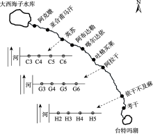
Fig. 1
Schematic diagram of the lower reaches of Tarim River and its nine sections"
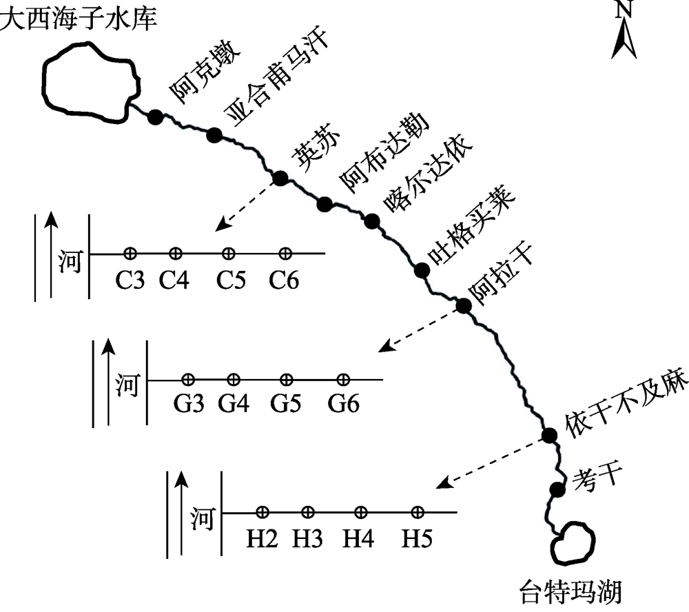

Fig. 2
Variations of the simulated and observed groundwater table for the monitoring wells at the three sections"
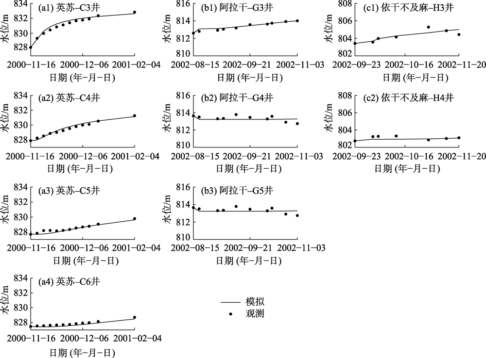

Fig. 3
Comparisons between simulated and observed mean annual groundwater table depths at the three sections"

Fig. 4
Variations of simulated mean annual groundwater table depths at the three sections"
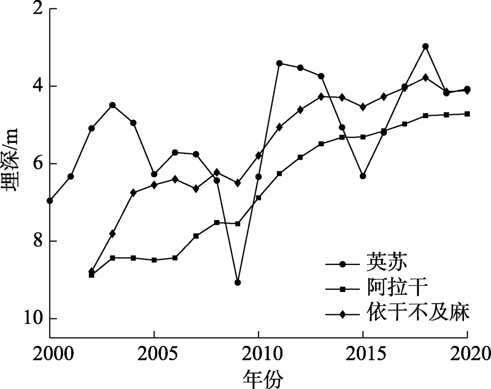
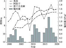
Fig. 5
Variations of accumulated annual ecological water conveyance amounts in the lower reaches of Tarim River and mean groundwater table depths at the three sections"

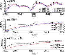
Fig. 6
Variations of mean annual groundwater table depths at different monitoring wells of each section"


Fig. 7
Annual variations of simulated mean 2-meter-depth soil moistures at the three sections"
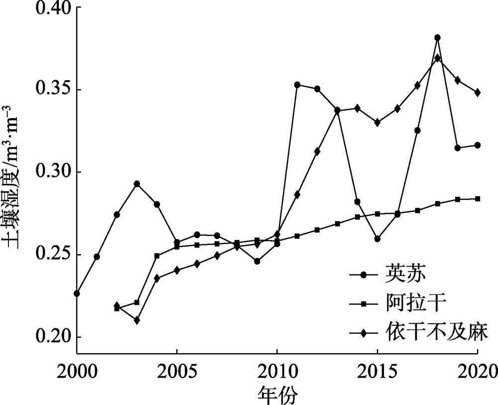
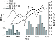
Fig. 8
Annual variations of accumulated ecological water conveyance amounts in the lower reaches of Tarim River and mean 2-meter-depth soil moistures at the three sections"

| [1] | 陈亚宁, 张小雷, 祝向民, 等. 新疆塔里木河下游断流河道输水的生态效应分析[J]. 中国科学: D辑, 2004,34(5):475-482. |
| [ Chen Yaning, Zhang Xiaolei, Zhu Xiangmin, et al. Analysis on the ecological benefits of the stream water conveyance to the dried-up river of the lower reaches of Tarim River, China[J]. Science in China: Series D, 2004,34(5):475-482. ] | |
| [2] |
Chen Y, Li W, Xu C, et al. Desert riparian vegetation and groundwater in the lower reaches of the Tarim River Basin[J]. Environmental Earth Sciences, 2015,73(2):547-558.
doi: 10.1007/s12665-013-3002-y |
| [3] | 马跃. 塔里木河下游生态输水对植被和地下水位的影响[J]. 生态环境与保护, 2020,3(4):37. |
| [ Ma Yue. Effects of ecological water transport on vegetation and groundwater level in the lower reaches of Tarim River[J]. Ecological Environment and Protection, 2020,3(4):37. ] | |
| [4] |
Ling H, Zhang P, Guo B, et al. Negative feedback adjustment challenges reconstruction study from tree rings: A study case of response of Populus euphratica to river discontinuous flow and ecological water conveyance[J]. Science of the Total Environment, 2017,574:109-119.
doi: 10.1016/j.scitotenv.2016.09.043 |
| [5] |
Mamat Z, Halik U, Keyimu M, et al. Variation of the floodplain forest ecosystem service value in the lower reaches of Tarim River, China[J]. Land Degradation and Development, 2018,29:47-57.
doi: 10.1002/ldr.2835 |
| [6] | Zhou H, Chen Y, Hao X, et al. Tree rings: A key ecological indicator for reconstruction of groundwater depth in the lower Tarim River, northwest China[J]. Ecohydrology, 2019,12:e2142, doi: 10.1002/eco.2142. |
| [7] |
Liao S, Xue L, Dong Z, et al. Cumulative ecohydrological response to hydrological processes in arid basins[J]. Ecological Indicators, 2020,111:106005, doi: 10.1016/j.ecolind.2019.106005.
doi: 10.1016/j.ecolind.2019.106005 |
| [8] | 秦景秀, 郝兴明, 张颖, 等. 气候变化和人类活动对干旱区植被生产力的影响[J]. 干旱区地理, 2020,43(1):117-125. |
| [ Qin Jingxiu, Hao Xingming, Zhang Ying, et al. Effects of climate change and human activities on vegetation productivity in arid areas[J]. Arid Land Geography, 2020,43(1):117-125. ] | |
| [9] | 孙天瑶, 李雪梅, 许民, 等. 2000—2018年塔里木河流域植被覆盖时空格局[J]. 干旱区地理, 2020,43(2):415-424. |
| [ Sun Tianyao, Li Xuemei, Xu Min, et al. Spatial temporal variations of vegetation coverage in the Tarim River Basin from 2000 to 2018[J]. Arid Land Geography, 2020,43(2):415-424. ] | |
| [10] | 陈亚宁. 新疆塔里木河流域生态保护与可持续管理[M]. 北京: 科学出版社, 2015. |
| [ Chen Yaning. Ecological protection and sustainable management of the Tarim River Basin[M]. Beijing: Science Press, 2015. ] | |
| [11] | 徐海量, 樊自立, 杨鹏年, 等. 塔里木河近期治理评估及对编制流域综合规划的建议[J]. 干旱区研究, 2016,33(2):223-229. |
| [ Xu Hailiang, Fan Zili, Yang Pengnian, et al. Evaluation on the management of Tarim River and advices for the future planning of the Tarim River Basin[J]. Arid Zone Research, 2016,33(2):223-229. ] | |
| [12] | 陈亚宁, 李卫红, 陈亚鹏, 等. 科技支撑新疆塔里木河流域生态修复及可持续管理[J]. 干旱区地理, 2018,41(5):901-907. |
| [ Chen Yaning, Li Weihong, Chen Yapeng, et al. Science in supporting the ecological restoration and sustainable development of the Tarim River Basin[J]. Arid Land Geography, 2018,41(5):901-907. ] | |
| [13] | 陈亚宁, 李卫红, 陈亚鹏, 等. 新疆塔里木河下游断流河道输水与生态恢复[J]. 生态学报, 2007,27:538-545. |
| [ Chen Yaning, Li Weihong, Chen Yapeng, et al. Water conveyance in dried-up riverway and ecological restoration in the lower reaches of Tarim River, China[J]. Acta Ecological Sinica, 2007,27(2):538-545. ] | |
| [14] | 湾疆辉, 陈亚宁, 李卫红, 等. 塔里木河下游断流河道输水后潜水埋深变化规律研究[J]. 干旱区地理, 2008,31(3):428-435. |
| [ Wan Jianghui, Chen Yaning, Li Weihong, et al. Variation of groundwater level after ecological water transport in the lower reaches of the Tarim River in recent six years[J]. Arid Land Geography, 2008,31(3):428-435. ] | |
| [15] | 刘迁迁, 古力米热∙哈那提, 苏里坦, 等. 塔里木河下游河岸带地下水埋深对生态输水的响应过程[J]. 干旱区地理, 2017,40(5):979-986. |
| [ Liu Qianqian, Gulimire Hanati, Sulitan, et al. Response process of groundwater table to ecological water conveyance in the lower reaches of Tarim River riparian zone[J]. Arid Land Geography, 2017,40(5):979-986. ] | |
| [16] | 李丽君, 张小清, 陈长清, 等. 近20 a塔里木河下游输水对生态环境的影响[J]. 干旱区地理, 2018,41(2):238-247. |
| [ Li Lijun, Zhang Xiaoqing, Chen Changqing, et al. Ecological effects of water conveyance on the lower reaches of Tarim River in recent twenty years[J]. Arid Land Geography, 2018,41(2):238-247. ] | |
| [17] | 刘斌, 赵雅莉, 白洁, 等. 塔里木河下游流域输水工程生态效应评价研究[J]. 地理空间信息, 2020,18(3):112-117. |
| [ Liu Bin, Zhao Yali, Bai Jie, et al. Ecological effect evaluation of water conveyance project in lower reaches of Tarim River[J]. Geospatial Information, 2020,18(3):112-117. ] | |
| [18] | 杨鹏年, 邓铭江, 董新光, 等. 间歇输水河道两侧一维地下水非稳定流运动研究——以塔里木河下游为例[J]. 干旱区地理, 2008,31(5):731-736. |
| [ Yang Pengnian, Deng Mingjiang, Dong Xinguang, et al. 1D groundwater transient movement of intermittent water transmitting[J]. Arid Land Geography, 2008,31(5):731-736. ] | |
| [19] | 刘迁迁, 古力米热∙哈那提, 王光焰, 等. 间歇性生态输水塔里木河下游断面地下水位变化模拟[J]. 生态学报, 2018,38(15):5519-5528. |
| [ Liu Qianqian, Gulimire Hanati, Wang Guangyan, et al. Simulation of sectional groundwater level variation in the lower reaches of Tarim River under intermittent ecological water conveyance[J]. Acta Ecologica Sinica, 2018,38(15):5519-5528. ] | |
| [20] | 古力米热∙哈那提, 张音, 关东海, 等. 生态输水条件下塔里木河下游断面尺度地下水流数值模拟[J]. 水科学进展, 2020,31(1):61-70. |
| [ Gulimire Hanati, Zhang Yin, Guan Donghai, et al. Numerical simulation of groundwater flow at cross-section scale in the lower reaches of Tarim River under the condition of ecological water conveyance[J]. Advances in Water Science, 2020,31(1):61-70. ] | |
| [21] | 狄振华, 谢正辉, 袁星, 等. 输水条件下考虑土壤水和地下水相互作用的河流剖面地下水埋深估计方法[J]. 中国科学: 地球科学, 2010,40(10):1420-1430. |
| [ Di Zhenhua, Xie Zhenghui, Yuan Xing, et al. Prediction of water table depths under soil water-groundwater interaction and stream water conveyance[J]. Science in China: Series D, 2010,40(10):1420-1430. ] | |
| [22] | 谢正辉, 罗振东, 曾庆存, 等. 非饱和土壤水流问题含水量和通量的数值模拟研究[J]. 自然科学进展, 1999,9(12):1280-1286. |
| [ Xie Zhenghui, Luo Zhendong, Zeng Qingcun, et al. Numerical simulation of water content and flux in unsaturated soil flow problems[J]. Progress in Natural Science, 1999,9(12):1280-1286. ] | |
| [23] | 钱亦兵, 周华荣, 赵锐锋, 等. 塔里木河中下游湿地及其周边土壤理化性状的空间异质性[J]. 水土保持学报, 2005,19(6):31-34. |
| [ Qian Yibing, Zhou Huarong, Zhao Ruifeng, et al. Spatial heterogeneity of soil physical-chemical properties for wetlands and surrounding lands in middle and lower reaches of Tarim River[J]. Journal of Soil and Water Conservation, 2005,19(6):31-34. ] | |
| [24] | 汪亮亮, 叶茂, 高生峰, 等. 水热因子对塔里木河下游胡杨年轮指数和植被指数的影响[J]. 南京林业大学学报(自然科学版), 2017,41(5):85-91. |
| [ Wang Liangliang, Ye Mao, Gao Shengfeng, et al. Effects of hydrothermal factors on vegetation index and tree-ring index of Populus euphratica in the lower reaches of the Tarim River[J]. Journal of Nanjing Forestry University (Natural Science Edition), 2017,41(5):85-91. ] | |
| [25] | 马晓东, 李卫红, 朱成刚, 等. 塔里木河下游土壤水分与植被时空变化特征[J]. 生态学报, 2010,30(5):4035-4045. |
| [ Ma Xiaodong, Li Weihong, Zhu Chenggang, et al. Spatio-temporal variation in soil moisture and vegetation along the lower reaches of Tarim River, China[J]. Acta Ecologica Sinica, 2010,30(5):4035-4045. ] | |
| [26] | Dickison R E, Henderson-sellers A, Kennedy P J, et al. Biosphere atmosphere transfer scheme (BATS) for NCAR community climate model[R]. NCAR Technical Note, NCAR/TN 275+STR, 1986. |
| [27] |
Clapp R B, Hornberger G M. Empirical equation for some soil hydraulic properties[J]. Water Resources Research, 1978,14:601-604.
doi: 10.1029/WR014i004p00601 |
| [28] |
Duan Q, Gupta V K, Sorooshian S. Effective and efficient global optimization for conceptual rainfall-runoff model[J]. Water Resources Research, 1992,28:1015-1031.
doi: 10.1029/91WR02985 |
| [29] | 白元, 徐海量, 张青青, 等. 基于地下水恢复的塔里木河下游生态需水量估算[J]. 生态学报, 2015,35(3):630-640. |
| [ Bai Yuan, Xu Hailiang, Zhang Qingqing, et al. Evaluation on ecological water requirement in the lower reaches of Tarim River based on groundwater restoration[J]. Acta Ecologica Sinica, 2015,35(3):630-640. ] | |
| [30] | 郭红雨. 塔里木河下游生态输水工程对地下水位变化的影响分析[J]. 西北水电, 2020,185(5):29-32. |
| [ Guo Hongyu. Analysis of the impact of the ecological water delivery project on the change of groundwater level in the lower reaches of the Tarim River[J]. Northwest Hydropower, 2020,185(5):29-32. ] |
| [1] | WANG Zhen, LI Junli, ZHANG Jiudan, WU Haoru, GUO Xuefei. Influences of ecological water conveyance on Populus euphratica forest restoration in the middle reaches of Tarim River [J]. Arid Land Geography, 2023, 46(1): 94-102. |
| [2] | ZHANG Jiudan, LI Junli, BAO Anming, BAI Jie, LIU Tie, HUANG Yue. Effectiveness assessment of ecological restoration of Populus euphratica forest in the Tarim River Basin during 2013—2020 [J]. Arid Land Geography, 2022, 45(6): 1824-1835. |
| [3] | PAN Zihao,YANG Shengtian,LOU Hezhen,YU Jingjie,WANG Zhongjing,ZHANG Jun. Remote sensing monitoring of ecological water conveyance and benefits evaluation of agricultural water-saving in arid basin without observation station [J]. Arid Land Geography, 2022, 45(3): 774-785. |
| [4] | NIE Yan,GUO Yongrui,TAN Ying,HUANG Weidong,LIU Xinhua. Operation optimization of ecological water conveyance in Aksu River Basin based on ecological restoration [J]. Arid Land Geography, 2022, 45(2): 325-332. |
| [5] | WANG Wanrui,Aikeremu Abula,CHEN Yaning,ZHU Chenggang,CHEN Yapeng. Groundwater recharge during ecological water conveyance in the lower reaches of Tarim River [J]. Arid Land Geography, 2021, 44(3): 670-680. |
| [6] | CHEN Yongjin,Aikeremu Abula,ZHANG Tianju,CHEN Yapeng,ZHU Chenggang,CHENG Yong,LIU Lu,LI Xiaoyang,ZHANG Qifei. Effects of ecological water conveyance on groundwater depth in the lower reaches of Tarim River [J]. Arid Land Geography, 2021, 44(3): 651-658. |
| [7] | ZHOU Honghua,CHEN Yapeng,YANG Yuhai,ZHU Chenggang. Effects of ecological water conveyance on the growth characteristics of Populus euphtatica in the lower reaches of Tarim River based on tree-rings [J]. Arid Land Geography, 2021, 44(3): 643-650. |
| [8] | YANG Yuhai,ZHU Chenggang,WANG Yang,ZHOU Honghua. Effects of ecological water conveyance on carbon cycle of Populus euphratica forest ecosystem in the lower reaches of Tarim River [J]. Arid Land Geography, 2021, 44(3): 637-642. |
| [9] | ZHU Chenggang,Aikeremu Abula,LI Weihong,ZHOU Honghua. Ecosystem restoration of Populus euphratica forest under the ecological water conveyance in the lower reaches of Tarim River [J]. Arid Land Geography, 2021, 44(3): 629-636. |
| [10] | FU Aihong,CHENG Yong,LI Weihong,ZHU Chenggang,CHEN Yapeng. Effects of ecological water conveyance on ecological resilience of desert riparian forests in the lower reaches of Tarim River [J]. Arid Land Geography, 2021, 44(3): 620-628. |
| [11] | CHEN Yapeng,ZHOU Honghua,ZHU Chenggang. A review of water transport processes of Populus euphratica in the lower reaches of Tarim River [J]. Arid Land Geography, 2021, 44(3): 612-619. |
| [12] | CHEN Yaning,Wumaierjiang Wubuli,Aikeremu Abula,CHENG Yong,CHEN Yapeng,HAO Xingming,ZHU Chenggang,WANG Yang. Monitoring and analysis of ecological benefits of water conveyance in the lower reaches of Tarim River in recent 20 years [J]. Arid Land Geography, 2021, 44(3): 605-611. |
| [13] | ZOU Shan,Jilili Abuduwaili,HUANG Wenjing,DUAN Weili. Effects of ecological water conveyance on changes of surface water area in the lower reaches of Tarim River [J]. Arid Land Geography, 2021, 44(3): 681-690. |
| [14] | HAO Haichao,HAO Xingming,CHENG Xiaoli,ZHANG Jingjing,FAN Xue,LI Yuanhang. Effects of ecological water conveyance on water use efficiency of desert riparian forest ecosystem in the lower reaches of Tarim River [J]. Arid Land Geography, 2021, 44(3): 691-699. |
| [15] | LI Yupeng,CHEN Yaning,YE Zhaoxia,WANG Fei,SUN Fan,QIN Jingxiu. Ecological responses of ecological water conveyance in the lower reaches of Tarim River for 20 years [J]. Arid Land Geography, 2021, 44(3): 700-707. |
| Viewed | ||||||||||||||||||||||||||||||||||||||||||||||||||
|
Full text 320
|
|
|||||||||||||||||||||||||||||||||||||||||||||||||
|
Abstract 365
|
|
|||||||||||||||||||||||||||||||||||||||||||||||||
Cited |
|
|||||||||||||||||||||||||||||||||||||||||||||||||
| Shared | ||||||||||||||||||||||||||||||||||||||||||||||||||
|
||