- Apr. 7, 2025
Arid Land Geography ›› 2021, Vol. 44 ›› Issue (1): 197-207.doi: 10.12118/j.issn.1000–6060.2021.01.21
• Earth Information Sciences • Previous Articles Next Articles
LIU Chang1,2( ),LI Chengzhi1,2,3(),LI Shenghui1,2,FU Xiaolei1,2,SHI Qingdong1,2,3
Received:2019-10-03
Revised:2020-04-20
Online:2021-01-25
Published:2021-03-09
Contact:
Chengzhi LI
E-mail:1781336744qq.com;xdlichengzhi@sina.com
LIU Chang,LI Chengzhi,LI Shenghui,FU Xiaolei,SHI Qingdong. Desertification analysis based on grid accumulation method in Tarim Basin, China[J].Arid Land Geography, 2021, 44(1): 197-207.
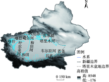
Fig. 1
The sketch map of Tarim Basin"

Tab. 1
Desertification classification in Tarim Basin"
| 沙漠化分级 | 非沙漠化 | 轻度沙漠化 | 中度沙漠化 | 重度沙漠化 | 极重度沙漠化 |
|---|---|---|---|---|---|
| 植被盖度/% | [100.0,60.0) | [60.0,40.0) | [40.0,26.7) | [26.7,13.3) | [13.3, 0) |
Tab. 2
Classification of desertification rate used in the grid accumulation method"
| 分级 | 超高速恶化 | 极高速恶化 | 高速恶化 | 中速恶化 | 低速恶化 | 无变化 |
|---|---|---|---|---|---|---|
| 值域范围 | [-100.0,-60.0) | [-60.0,-40.0) | [-40.0,-26.7) | [-26.7,-13.3) | [-13.3,-6.0) | [-6.0,6.0] |
| 分级 | 低速改善 | 中速改善 | 高速改善 | 极高速改善 | 超高速改善 | |
| 值域范围 | (6.0,13.3] | (13.3,26.7] | (26.7,40.0] | (40.0,60.0] | (60.0,100.0] |

Fig. 2
Desertification change in Tarim Basin during 2000—2018"

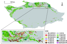
Fig. 3
Accumulate spatial distribution of desertification using the grid accumulation method in Tarim Basin during 2000—2018"


Fig. 4
Transformed area of desertification in Tarim Basin during 2000—2018"
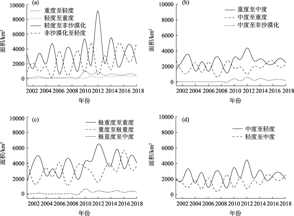
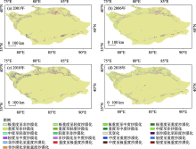
Fig. 5
Spatial distribution of the transformed desertification in Tarim Basin"

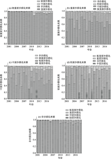
Fig. 6
Sources of desertification transformation in Tarim Basin"


Fig. 7
Analysis of the desertification change rate of land-use type in Tarim Basin"

| [1] | 刘兴文, 姜小光. 不同时相遥感图像光机复合处理提取土地荒漠化信息研究[J]. 干旱区地理, 1996,19(3):1-7. |
| [ Liu Xingwen, Jiang Xiaoguang. Extraction of the change information of land desertification form multitemporal remote sensing images by the method of combining optical false color composite with computer digital image processing[J]. Arid Land Geography, 1996,19(3):1-7. ] | |
| [2] | 朱震达. 中国土地荒漠化的概念、成因与防治[J]. 第四纪研究, 1998,18(2):145-155. |
| [ Zhu Zhenda. Concept, cause and control of desertification in China[J]. Quaternary Sciences, 1998,18(2):145-155. ] | |
| [3] | 王涛. 中国沙漠与沙漠化[M]. 石家庄: 河北科学技术出版社, 2003, 137-141. |
| [ Wang Tao. Deserts and desertification in China[M]. Shijiazhuang: Hebei Science and Technology Press, 2003, 137-141. ] | |
| [4] |
Meyer W B, Turner II B L. Human population growth and global land-use/cover change[J]. Annual Review of Ecology & Systematics, 1992,23(23):39-61.
doi: 10.1146/annurev.es.23.110192.000351 |
| [5] | Jacquin A, Sheeren D, Lacombe J P, et al. Vegetation cover degradation assessment in Madagascar savanna based on trend analysis of MODIS NDVI time series[J]. International Journal of Applied Earth Observations & Geoinformation, 2010,12(13):S3-S10. |
| [6] | 赵鸿雁, 陈英, 周翼, 等. 甘肃中东部植被生长季NDVI时空变化及其对气候因子的响应[J]. 干旱区地理, 2019,42(6):1427-1435. |
| [ Zhao Hongyan, Chen Ying, Zhou Yi, et al. Land cover type classification and potential desertificion area detecting in Xinjiang based on MODIS NDVI imagery[J]. Arid Land Geography, 2019,42(6):1427-1435. ] | |
| [7] |
刘洋, 李诚志, 刘志辉, 等. 1982—2013年基于GIMMS-NDVI的新疆植被覆盖时空变化[J]. 生态学报, 2016,36(19):6198-6208.
doi: 10.5846/stxb201506071149 |
|
[ Liu Yang, Li Chengzhi, Liu Zhihui, et al. Assessment of spatio-temporal variations in vegetation cover in Xinjiang from 1982 to 2013 based on GIMMS-NDVI[J]. Acta Ecologica Sinica, 2016,36(19):6198-6208. ]
doi: 10.5846/stxb201506071149 |
|
| [8] |
Mutti P R, Lúcio P S, Dubreuil V, et al. NDVI time series stochastic models for the forecast of vegetation dynamics over desertification hotspots[J]. International Journal of Remote Sensing, 2020,41(7):2759-2788.
doi: 10.1080/01431161.2019.1697008 |
| [9] | 唐亮, 何明珠, 许华, 等. 基于无人机低空遥感的荒漠植被覆盖度与归一化植被指数验证及其对水热梯度的响应[J]. 应用生态学报, 2020,31(1):35-44. |
| [ Tang Liang, He Mingzhu, Xu Hua, et al. Validation of vegetation coverage and NDVI based on UAV remote sensing method and its response to hydrothermal gradient[J]. Chinese Journal of Applied Ecology, 2020,31(1):35-44. ] | |
| [10] |
Guo B, Zang W Q, Han B M, et al. Dynamic monitoring of desertification in Naiman Banner based on feature space models with typical surface parameters derived from LANDSAT images[J]. Land Degradation & Development, 2020, doi: 10.1002/idr.3533
doi: 10.1002/ldr.2595 pmid: 30393450 |
| [11] | 周梦甜, 李军, 朱康文. 近15 a新疆不同类型植被NDVI时空动态变化及对气候变化的响应[J]. 干旱区地理, 2015,38(4):779-787. |
| [ Zhou Mengtian, Li Jun, Zhu Kangwen. Spatial-temporal dynamics of different types of vegetation NDVI and its response to climate change in Xinjiang during 1998—2012[J]. Arid Land Geography, 2015,38(4):779-787. ] | |
| [12] | 李诚志. 新疆土地沙漠化监测与预警研究[D]. 乌鲁木齐: 新疆大学, 2012. |
| [ LI Chengzhi. Study on the desertification monitoring and early-warning in Xinjiang[D]. Urumqi: Xinjiang University, 2012. ] | |
| [13] | 王涛, 宋翔, 颜长珍, 等. 近35 a来中国北方土地沙漠化趋势的遥感分析[J]. 中国沙漠, 2011,31(6):1351-1356. |
| [ Wang Tao, Song Xiang, Yan Changzhen, et al. Remote sensing analysis on aeolian desertification trends in northern China during 1975—2010[J]. Journal of Desert Research, 2011,31(6):1351-1356. ] | |
| [14] | 张建生, 闫正龙, 王晓国, 等. 塔里木河下游沙漠化土地时空变化遥感分析[J]. 农业工程学报, 2009,25(10):161-165. |
| [ Zhang Jianshen, Yan Zhenglong, Wang Xiaoguo, et al. Remote sensing analysis of spatial-temporal changes of desertification land in lower reaches of Tarim River[J]. Agricultural Engineering, 2009,25(10):161-165. ] | |
| [15] | 宋豫秦, 陈妍. 荒漠化预警方法研究进展[J]. 中国沙漠, 2017,37(2):205-213. |
| [ Song Yuqin, Chen Yan. A review of desertification early warning methods[J]. Journal of Desert Research, 2017,37(2):205-213. ] | |
| [16] | 张立运. 塔里木盆地诸大河沿岸的天然草地及其人为活动的影响[J]. 干旱区资源与环境, 1990,4(1):68-76. |
| [ Zhang Liyun. The natural grasslands on the flowing plains along the large rivers in Tarim Basin and the affects of the mankind activities[J]. Journal of Arid Land Resources and Environment, 1990,4(1):68-76. ] | |
| [17] | 史培军, 严平, 高尚玉, 等. 我国沙尘暴灾害及其研究进展与展望[J]. 自然灾害学报, 2000,9(3):71-77. |
| [ Shi Peijun, Yan Ping, Gao Shangyu, et al. The duststorm disaster in China and its research progress[J]. Journal of Natural Disasters, 2000,9(3):71-77. ] | |
| [18] | 李军, 朱慧. 重庆地区MODIS/NDVI时间序列数据重建研究[J]. 地理科学, 2017,37(3):120-127. |
| [ Li Jun, Zhu Hui. The reconstruction of MODIS/NDVI time series data in Chongqing[J]. Scientia Geographica Sinica, 2017,37(3):120-127. ] | |
| [19] |
邓煜霖, 姜红涛, 张飞, 等. 艾比湖流域NDVI垂直梯度变化特征[J]. 中国沙漠, 2015,35(2):508-513.
doi: 10.7522/j.issn.1000-694X.2014.00173 |
|
[ Deng Yulin, Jiang Hongtao, Zhang Fei, et al. NDVI at a vertical gradient in the Ebinur Lake Basin, Xinjiang, China[J]. Journal of Desert Research, 2015,35(2):508-513. ]
doi: 10.7522/j.issn.1000-694X.2014.00173 |
|
| [20] |
Tucker C J, Newcomb W W, Dregne H E. AVHRR data sets for determination of desert spatial extent[J]. International Journal of Remote Sensing, 1994,15(17):3547-3565.
doi: 10.1080/01431169408954344 |
| [21] | 陈亚宁, 李卫红, 陈亚鹏, 等. 科技支撑新疆塔里木河流域生态修复及可持续管理[J]. 干旱区地理, 2018,41(5):901-907. |
| [ Chen Yaning, LI Weihong, Chen Yapeng, et al. Science in supporting the ecological restoration and sustainable development of the Tarim River Basin[J]. Arid Land Geography, 2018,41(5):901-907. ] | |
| [22] | 苏冰倩, 王茵茵, 上官周平. 西北地区新一轮退耕还林还草规模分析[J]. 水土保持研究, 2017,24(4):59-65. |
| [ Su Bingqian, Wang Yinyin, Shangguan Zhouping. Analysis on the scale of a new period of returning farmland to forestland and grassland in northwest China[J]. Research of Soil and Water Conservation, 2017,24(4):59-65. ] | |
| [23] | 李诚志, 张燕, 刘志辉, 等. 新疆地区沙漠化对气候变化的响应与治理对策[J]. 水土保持通报, 2014,34(4):264-268. |
| [ Li Chengzhi, Zhang Yan, Liu Zhihui, et al. Response and control mechanism of desertification to climate change in Xinjiang region[J]. Bulletin of Soil and Water Conservation, 2014,34(4):264-268. ] | |
| [24] |
马金珠, 李吉均. 塔里木盆地南缘人类活动干扰下地下水的变化及其生态环境效应[J]. 自然资源学报, 2001,16(2):134-139.
doi: 10.11849/zrzyxb.2001.02.006 |
|
[ Ma Jinzhu, Li Jijun. Impact of human activities on groundwater and the effect on eco-environment in southern Tarim Basin[J]. Journal of Natural Resources, 2001,16(2):134-139. ]
doi: 10.11849/zrzyxb.2001.02.006 |
|
| [25] | 赵明伟, 王妮, 施慧慧, 等. 2001—2015年间我国陆地植被覆盖度时空变化及驱动力分析[J]. 干旱区地理, 2019,42(2):104-111. |
| [ Zhao Mingwei, Wang Ni, Shi Huihui, et al. Spatial-temporal variation and its driving forces of vegetation coverage in China from 2001 to 2015[J]. Quaternary Sciences, 2019,42(2):104-111. ] | |
| [26] |
李诚志, 张燕, 刘洋, 等. 塔里木河下游居民沙漠化认知[J]. 中国沙漠, 2016,36(5):1271-1277.
doi: 10.7522/j.issn.1000-694X.2015.00280 |
|
[ Li Chengzhi, Zhang Yan, Liu Yang, et al. Residents cognition to desertification in the lower reaches of the Tarim River[J]. Journal of Desert Research, 2016,36(5):1271-1277. ]
doi: 10.7522/j.issn.1000-694X.2015.00280 |
|
| [27] | 陈亚宁, 李卫红, 陈亚鹏, 等. 新疆塔里木河下游断流河道输水与生态恢复[J]. 生态学报, 2006,27(2):538-545. |
| [ Chen Yaning, Li Weihong, Chen Yapeng, et al. Water conveyance in dried-up river way and ecological restoration in the lower reaches of Tarim River, China[J]. Journal of Ecology, 2006,27(2):538-545. ] | |
| [28] | 杨光华, 包安明, 陈曦, 等. 1998—2007年新疆植被覆盖变化及驱动因素分析[J]. 冰川冻土, 2009,31(3):436-445. |
| [ Yang Guanghua, Bao Anming, Chen Xi, et al. Study of the vegetation cover change and its driving factors over Xinjiang during 1998—2007[J]. Journal of Glaciology and Geocryology, 2009,31(3):436-445. ] | |
| [29] | 王非, 毋兆鹏, 汪洋, 等. 基于RS和GIS的塔里木盆地荒漠化动态监测[J]. 生态学杂志, 2017,36(4):1029-1037. |
| [ Wang Fei, Wu Zhaopeng, Wang Yang, et al. Dynamic monitoring of dsertification in the Tarim Basin based on RS and GIS techniques[J]. Chinese Journal of Ecology, 2017,36(4):1029-1037. ] |
| [1] | ZHANG Qifei, CHEN Yaning, SUN Congjian, XIANG Yanyun, HAO Haichao. Changes in terrestrial water storage and evaluation of oasis ecological security in the Tarim River Basin [J]. Arid Land Geography, 2024, 47(1): 1-14. |
| [2] | ZHANG Yujie,WANG Ninglian,YANG Xuewen,TAI Xuenan. Dynamic monitoring of Balkhash Lake from 1970 to 2020 based on multi-source remote sensing data [J]. Arid Land Geography, 2022, 45(2): 499-511. |
| [3] | SUN Guili,LI Xue,LIU Yanyan,ZHENG Jiaxiang,MA Jing,RAN Yajun. Dynamic changes on desertification risk assessment and driving force analysis in Turpan City [J]. Arid Land Geography, 2022, 45(2): 401-412. |
| [4] | WU Jingquan, WU Mingwan, ZANG Chuanfu. Land use change and land ecological security assessment in the river basins of northwestern China [J]. Arid Land Geography, 2021, 44(5): 1471-1482. |
| [5] | TANG Min,ZHANG Feng,SHI Qingdong. Variations in groundwater table depth at Daliyaboyi Oasis, Keriya River, China [J]. Arid Land Geography, 2021, 44(1): 80-88. |
| [6] | HE Ke, WU Shi-xin, YANG Yi, WANG Dan, ZHANG Shou-yu, YIN Nan. Dynamic changes of land use and oasis in Xinjiang in the last 40 years [J]. 干旱区地理, 2018, 41(6): 1333-1340. |
| [7] | ZHANG Lian-wei, LANG Jie, LI Li. Historical evolution of sandy desertification in ancient China [J]. 干旱区地理, 2018, 41(6): 1270-1277. |
| [8] | MA Jian-jun, PAN Mei-hui, WU Yong-qiu, XUE Wen-xuan. Geomorphological pattern and its change of aeolian landform in Dingjie area of Tibet from 1996 to 2016 [J]. 干旱区地理, 2018, 41(5): 1035-1042. |
| [9] | DAI Zhao-xin, HU Yun-feng, Renbo, ZHANG Yun-zhi. Spatial patterns and dynamic changes of eastern Silk Road city group regional self-development capacity from 1990 to 2013 [J]. , 2016, 39(4): 909-917. |
| [10] | MI Zhi-juan,MU Xing-min,ZHAO Guang-ju. Extraction of check dam based on multi-sources data in the Huangfuchuan watershed [J]. , 2015, 38(1): 52-59. |
| [11] | LI Chun-lan,CHAO Lumeng,BAO Yu-hai,YIN Shan,ZHANG Ji-quan,Alatengtuya,BAO Gang,HU Ri-cha,LUO Juan. Dynamic changes of desertification in the Hunshandake Desert under the climate fluctuation in early 21st Century [J]. , 2008, 38(3): 556-564. |
| Viewed | ||||||||||||||||||||||||||||||||||||||||||||||||||
|
Full text 325
|
|
|||||||||||||||||||||||||||||||||||||||||||||||||
|
Abstract 343
|
|
|||||||||||||||||||||||||||||||||||||||||||||||||
Cited |
|
|||||||||||||||||||||||||||||||||||||||||||||||||
| Shared | ||||||||||||||||||||||||||||||||||||||||||||||||||
|
||