Arid Land Geography ›› 2021, Vol. 44 ›› Issue (1): 208-220.doi: 10.12118/j.issn.1000–6060.2021.01.22
• Earth Information Sciences • Previous Articles Next Articles
CHENG Haoran1( ),MENG Jijun1(),ZHU Likai2
Received:2020-05-10
Revised:2020-10-25
Online:2021-01-25
Published:2021-03-09
Contact:
Jijun MENG
E-mail:hrcheng@pku.edu.cn;jijunm@pku.edu.cn
CHENG Haoran,MENG Jijun,ZHU Likai. Spatial-temporal pattern and trade-offs of land multi-function in the middle reaches of the Heihe River based on multi-source geographic data fussion[J].Arid Land Geography, 2021, 44(1): 208-220.

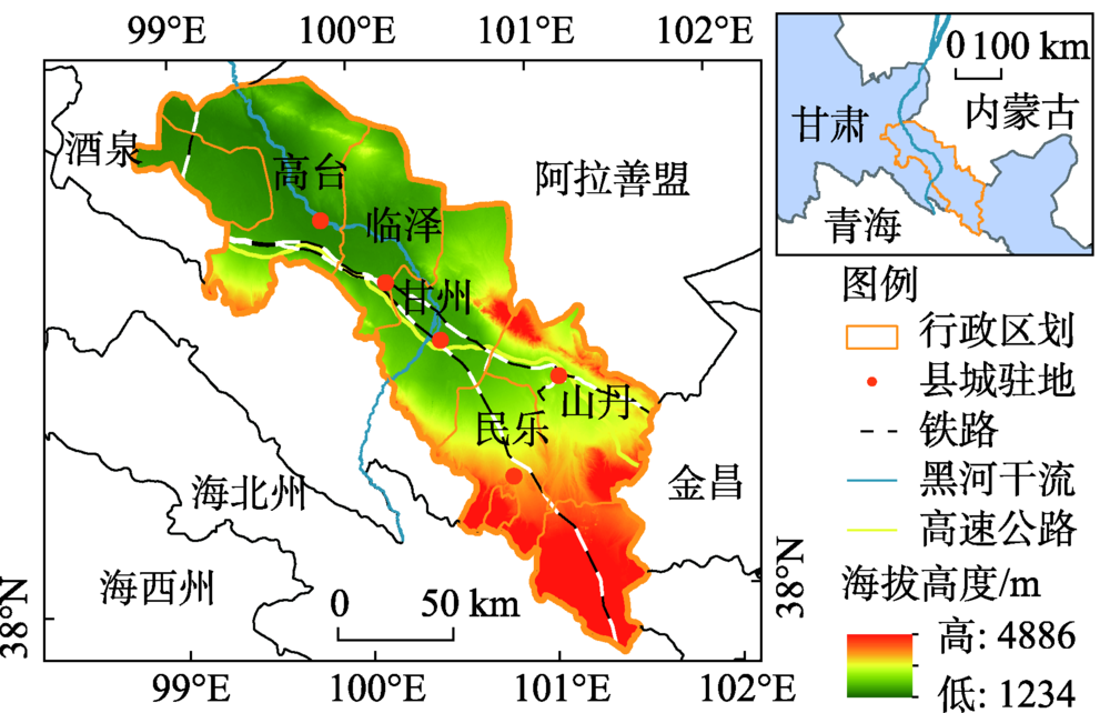
Fig. 1
Geographical location of the middle reaches of the Heihe River"
Tab. 1
Evaluation index system of land multi-function of the study area"
| 目标层 | 准则层 | 指标层(作用方向) | 数据层 | 2013年权重 | 2016年权重 |
|---|---|---|---|---|---|
| 生产功能 | 农业生产 | 第一产业增加值X1 (+) | 第一产业增加值总额/104元 | 0.1383 | 0.1526 |
| 猪牛羊肉产量X2 (+) | 猪牛羊肉总产量/104 kg | 0.0651 | 0.0690 | ||
| 有效灌溉面积X3 (+) | 有效灌溉面积/hm2 | 0.1526 | 0.1592 | ||
| 经济生产 | 第二三产业增加值X4 (+) | 第二三产业增加值总额/104元 | 0.0785 | 0.0703 | |
| 交通运输 | 交通设施密度X5 (+) | 百度地图交通设施POI | 0.1563 | 0.1739 | |
| 生活功能 | 就业支持 | 城镇居民可支配收入X6 (+) | 城镇居民可支配收入总额/元 | 0.0505 | 0.0613 |
| 农村居民可支配收入X7 (+) | 农村居民可支配收入总额/元 | 0.0697 | 0.0528 | ||
| 第二三产业从业人员规模X8 (+) | 第二三产业从业人员总数/人 | 0.0301 | 0.0524 | ||
| 居住家园 | 生活设施密度X9 (+) | 百度地图生活设施POI | 0.0632 | 0.0626 | |
| 自来水受益户数比X10 (+) | 自来水受益户数/总户数 | 0.0532 | 0.0668 | ||
| 健康保障 | 医疗设施密度X11 (+) | 百度地图医疗设施POI | 0.0507 | 0.0215 | |
| 生态功能 | 生态维持 | 土壤侵蚀强度X12 (-) | 土壤侵蚀强度 | 0.0235 | 0.0197 |
| 林地面积比例X13 (+) | 林地面积/土地总面积 | 0.0365 | 0.0226 | ||
| 减轻污染 | 化肥施用强度X14 (-) | 化肥施用实物量/t | 0.0318 | 0.0154 |

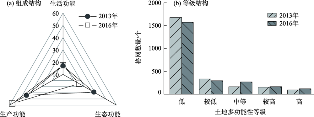
Fig. 2
Spatialization results of transportation, living and medical facilities in the study area"
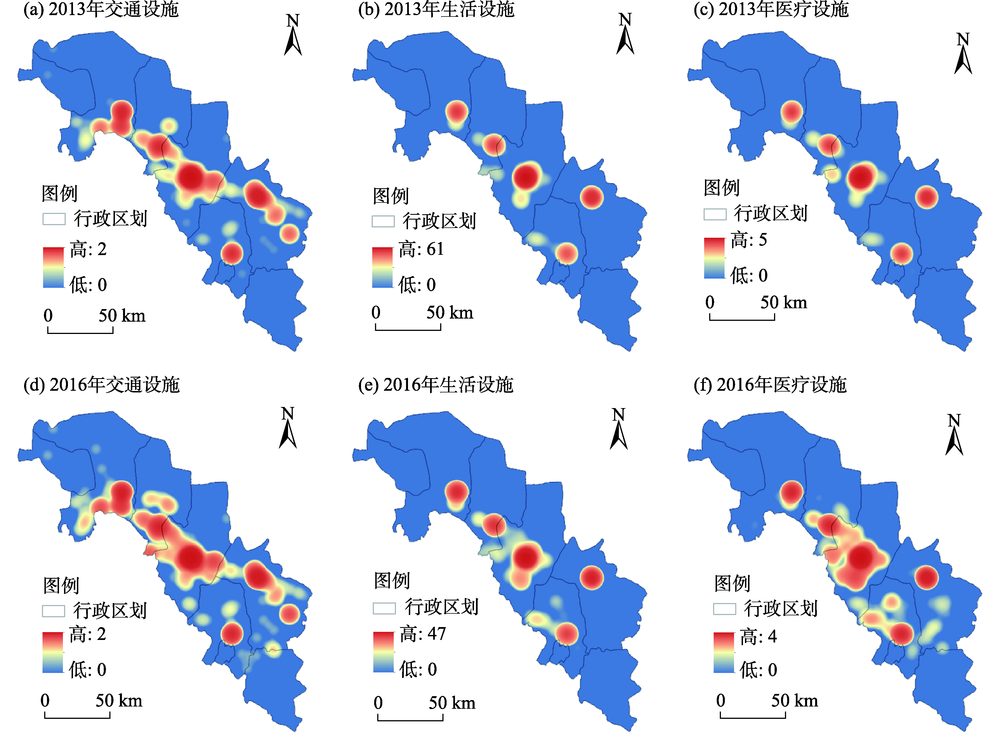

Fig. 3
Composition and grade structures of land multi-function in the middle reaches of the Heihe River"
Tab. 2
Classification thresholds of the natural break point method"
| 年份 | 低 | 较低 | 中等 | 较高 | 高 |
|---|---|---|---|---|---|
| 2013 | 0.3248 | 0.5959 | 0.9710 | 1.4776 | 2.3398 |
| 2016 | 0.2510 | 0.5165 | 0.8753 | 1.3148 | 1.9034 |

Fig. 4
Assessment result of land multi-function and hot spot distributions in the middle reaches of the Heihe River"
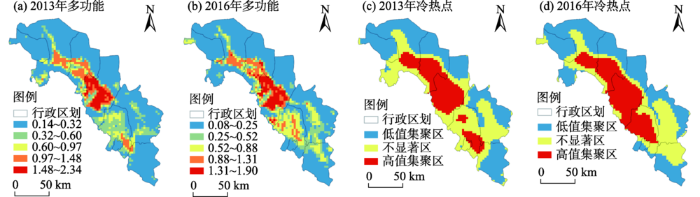

Fig. 5
Assessment result of production function and hot spot distributions in the middle reaches of the Heihe River"
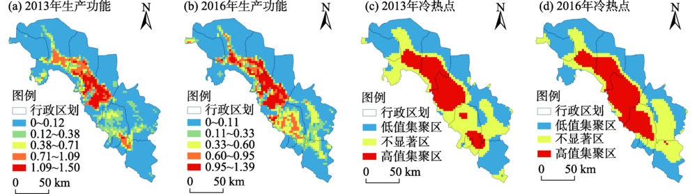
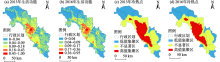
Fig. 6
Assessment result of living function and hot spot distributions in the middle reaches of the Heihe River"


Fig. 7
Assessment result of ecological function and hot spot distributions in the middle reaches of the Heihe River"
Tab. 3
Spearman correlation coefficients between primary land functions in the middle reaches of the Heihe River"
| 2013年 | 2016年 | ||
|---|---|---|---|
| 生产功能 | 生活功能 | 生态功能 | |
| 生产功能 | - | 0.647** | -0.123** |
| 生活功能 | 0.565** | - | -0.241** |
| 生态功能 | -0.053** | -0.221** | - |
Tab. 4
Spearman correlation coefficients between secondary land functions in the middle reaches of the Heihe River"
| 2013年 | 2016年 | ||||||||||
|---|---|---|---|---|---|---|---|---|---|---|---|
| 生产功能 | 生活功能 | 生态功能 | |||||||||
| 农业生产 | 经济生产 | 交通运输 | 居住家园 | 就业支持 | 健康保障 | 生态维持 | 减轻污染 | ||||
| 生产功能 | 农业生产 | - | 0.466** | 0.611** | 0.606** | 0.623** | 0.695** | 0.338** | -0.907** | ||
| 经济生产 | 0.446** | - | 0.555** | 0.466** | 0.421** | 0.524** | 0.056** | -0.418** | |||
| 交通运输 | 0.481** | 0.526** | - | 0.564** | 0.518** | 0.797** | 0.033 | -0.626** | |||
| 生活功能 | 居住家园 | 0.520** | 0.480** | 0.504** | - | 0.964** | 0.695** | 0.031 | -0.564** | ||
| 就业支持 | 0.542** | 0.429** | 0.477** | 0.970** | - | 0.643** | 0.072** | -0.559** | |||
| 健康保障 | 0.555** | 0.549** | 0.748** | 0.569** | 0.539** | - | 0.108** | -0.698** | |||
| 生态功能 | 生态维持 | 0.388** | 0.052* | 0.013 | 0.043* | 0.075** | 0.109** | - | -0.256** | ||
| 减轻污染 | -0.964** | -0.429** | -0.496** | -0.504** | -0.524** | -0.569** | -0.316** | - | |||

Fig. 8
Bivariate LISA cluster map among primary land functions in the middle reaches of the Heihe River"
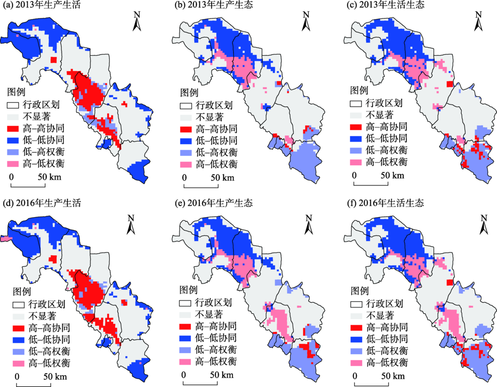
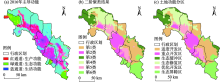
Fig. 9
Dominant function, result of two-step clustering and land functional zoning in the middle reaches of the Heihe River"

| [1] | 蒙吉军. 土地评价与管理[M]. 3版. 北京: 科学出版社, 2019. |
| [ Meng Jijun. Land evaluation and management [M]. 3rd ed. Beijing: Science Press, 2019. ] | |
| [2] |
Verburg P H, van de Steeg J, Veldkamp A, et al. From land cover change to land function dynamics: A major challenge to improve land characterization[J]. Journal of Environmental Management, 2009,90(3):1327-1335.
doi: 10.1016/j.jenvman.2008.08.005 pmid: 18809242 |
| [3] |
Foley J A, Ramankutty N, Brauman K A, et al. Solutions for a cultivated planet[J]. Nature, 2011,478(7369):337-342.
doi: 10.1038/nature10452 pmid: 21993620 |
| [4] | 王枫, 董玉祥. 基于灰色关联投影法的土地利用多功能动态评价及障碍因子诊断——以广州市为例[J]. 自然资源学报, 2015,30(10):1698-1713. |
| [ Wang Feng, Dong Yuxiang. Dynamic evaluation of land use functions based on grey relation projection method and diagnosis of its obstacle indicators: A case study of Guangzhou City[J]. Journal of Natural Resources, 2015,30(10):1698-1713. ] | |
| [5] | 张晓平, 朱道林, 许祖学. 西藏土地利用多功能性评价[J]. 农业工程学报, 2014,30(6):185-194. |
| [ Zhang Xiaoping, Zhu Daolin, Xu Zuxue. Assessment on multi-functionality of land use in Tibet[J]. Transactions of the Chinese Society of Agricultural Engineering, 2014,30(6):185-194. ] | |
| [6] | 朱琳, 黎磊, 刘素, 等. 大城市郊区村域土地利用功能演变及其对乡村振兴的启示——以成都市江家堰村为例[J]. 地理研究, 2019,38(3):535-549. |
| [ Zhu Lin, Li Lei, Liu Su, et al. The evolution of village land-use function in the metropolitan suburbs and its inspiration to rural revitalization: A case study of Jiangjiayan Village in Chengdu City[J]. Geographical Research, 2019,38(3):535-549. ] | |
| [7] | Mander Ü, Helming K, Wiggering H. Multifunctional land use: Meeting future demands for landscape goods and services[M]. Berlin, Heidelberg: Springer, 2007. |
| [8] | 甄霖, 曹淑艳, 魏云洁, 等. 土地空间多功能利用: 理论框架及实证研究[J]. 资源科学, 2009,31(4):544-551. |
| [ Zhen Lin, Cao Shuyan, Wei Yunjie, et al. Land use functions: Conceptual framework and application for China[J]. Resources Science, 2009,31(4):544-551. ] | |
| [9] | OECD. Multifunctionality: Towards an analytical framework[M]. Paris: Organization for Economic Co-operation and Development (OECD), 2001. |
| [10] |
Paracchini M L, Pacini C, Jones M L M, et al. An aggregation framework to link indicators associated with multifunctional land use to the stakeholder evaluation of policy options[J]. Ecological Indicators, 2011,11(1):71-80.
doi: 10.1016/j.ecolind.2009.04.006 |
| [11] | Pérez-Soba M, Petit S, Jones L, et al. Land use functions: A multifunctionality approach to assess the impact of land use changes on land use sustainability [C]//Helming K, Pérez-Soba M, Tabbush P. Sustainability Impact Assessment of Land Use Changes. Berlin, Heidelberg: Springer, 2008: 375-404. |
| [12] | 甄霖, 魏云洁, 谢高地, 等. 中国土地利用多功能性动态的区域分析[J]. 生态学报, 2010,30(24):6749-6761. |
| [ Zhen Lin, Wei Yunjie, Xie Gaodi, et al. Regional analysis of dynamic land use functions in China[J]. Acta Ecologica Sinica, 2010,30(24):6749-6761. ] | |
| [13] | 郭欢欢, 李波, 侯鹰. 基于土地功能的土地资源承载力研究——以北京市海淀区为例[J]. 北京师范大学学报(自然科学版), 2011,47(4):424-427. |
| [ Guo Huanhuan, Li Bo, Hou Ying. Research on the capacity of land resources based on land function: Haidian as an example[J]. Journal of Beijing Normal University(Natural Science), 2011,47(4):424-427. ] | |
| [14] |
范业婷, 金晓斌, 项晓敏, 等. 苏南地区耕地多功能评价与空间特征分析[J]. 资源科学, 2018,40(5):980-992.
doi: 10.18402/resci.2018.05.11 |
|
[ Fan Yeting, Jin Xiaobin, Xiang Xiaomin, et al. Evaluation and spatial characteristics of arable land multifunction in southern Jiangsu[J]. Resources Science, 2018,40(5):980-992. ]
doi: 10.18402/resci.2018.05.11 |
|
| [15] |
戴尔阜, 王晓莉, 朱建佳, 等. 生态系统服务权衡: 方法、模型与研究框架[J]. 地理研究, 2016,35(6):1005-1016.
doi: 10.11821/dlyj201606001 |
|
[ Dai Erfu, Wang Xiaoli, Zhu Jianjia, et al. Methods, tools and research framework of ecosystem service trade-offs[J]. Geographical Research, 2016,35(6):1005-1016. ]
doi: 10.11821/dlyj201606001 |
|
| [16] |
Barbier E B, Koch E W, Silliman B R, et al. Coastal ecosystem-based management with nonlinear ecological functions and values[J]. Science, 2008,319(5861):321-323.
doi: 10.1126/science.1150349 pmid: 18202288 |
| [17] |
钱彩云, 巩杰, 张金茜, 等. 甘肃白龙江流域生态系统服务变化及权衡与协同关系[J]. 地理学报, 2018,73(5):868-879.
doi: 10.11821/dlxb201805007 |
|
[ Qian Caiyun, Gong Jie, Zhang Jinxi, et al. Change and tradeoffs-synergies analysis on watershed ecosystem services: A case study of Bailongjiang Watershed, Gansu[J]. Acta Geographica Sinica, 2018,73(5):868-879. ]
doi: 10.11821/dlxb201805007 |
|
| [18] | Wu J. Landscape sustainability science: Ecosystem services and human well-being in changing landscapes[J]. Landscape Ecology, 2013,28(6):999-1023. |
| [19] | Bai Y, Zhuang C, Ouyang Z Y, et al. Spatial characteristics between biodiversity and ecosystem services in a human-dominated watershed[J]. Ecological Complexity, 2011,8(2):177-183. |
| [20] | 朱庆莹, 胡伟艳, 赵志尚. 耕地多功能权衡与协同时空格局的动态分析——以湖北省为例[J]. 经济地理, 2018,38(7):143-153. |
| [ Zhu Qingying, Hu Weiyan, Zhao Zhishang. Dynamic analysis on spatial-temporal pattern of trade-offs and synergies of multifunctional cultivated land: Evidence from Hubei Province[J]. Economic Geography, 2018,38(7):143-153. ] | |
| [21] | 王川, 刘春芳, 乌亚汗, 等. 黄土丘陵区生态系统服务空间格局及权衡与协同关系——以榆中县为例[J]. 生态学杂志, 2019,38(2):521-531. |
| [ Wang Chuan, Liu Chunfang, Wu Yahan, et al. Spatial pattern, tradeoffs and synergies of ecosystem services in loess hilly region: A case study in Yuzhong County[J]. Chinese Journal of Ecology, 2019,38(2):521-531. ] | |
| [22] |
Egoh B N, Reyers B, Rouget M, et al. Identifying priority areas for ecosystem service management in South African grasslands[J]. Journal of Environmental Management, 2011,92(6):1642-1650.
doi: 10.1016/j.jenvman.2011.01.019 pmid: 21334134 |
| [23] | 李双成, 张才玉, 刘金龙, 等. 生态系统服务权衡与协同研究进展及地理学研究议题[J]. 地理研究, 2013,32(8):1379-1390. |
| [ Li Shuangcheng, Zhang Caiyu, Liu Jinlong, et al. The tradeoffs and synergies of ecosystem services: Research progress, development trend, and themes of geography[J]. Geographical Research, 2013,32(8):1379-1390. ] | |
| [24] | 方莹, 王静, 孔雪松, 等. 耕地利用多功能权衡关系测度与分区优化——以河南省为例[J]. 中国土地科学, 2018,32(11):57-64. |
| [ Fang Ying, Wang Jing, Kong Xuesong, et al. Trade-off relation measurement and zoning optimization of multi-functionality of cultivated land use: A case study of Henan Province[J]. China Land Science, 2018,32(11):57-64. ] | |
| [25] | Zhou D, Xu J, Lin Z. Conflict or coordination? Assessing land use multi-functionalization using production-living-ecology analysis[J]. Science of the Total Environment, 2017,577:136-147. |
| [26] | 王晓君, 石敏俊, 王磊. 黑河中游水资源空间动态优化配置——基于分布式水资源管理模型[C]//中国自然资源学会2011年学术年会论文集(下册). 乌鲁木齐: 中国自然资源学会, 2011: 479-486. |
| [ Wang Xiaojun, Shi Minjun, Wang Lei. Spatial dynamic optimal allocation of water resources in the middle reaches of Heihe River: Based on distributed water resources management model[C]//Proceedings of the 2011 Annual Conference of China Society of Natural Resources (Vol. 2). Urumqi: China Society of Natural Resources, 2011: 479-486. ] | |
| [27] | 杜巧玲, 许学工, 刘文政. 黑河中下游绿洲生态安全评价[J]. 生态学报, 2004,24(9):1916-1923. |
| [ Du Qiaoling, Xu Xuegong, Liu Wenzheng. Ecological security assessment for the oases in the middle and lower Heihe River[J]. Acta Ecologica Sinica, 2004,24(9):1916-1923. ] | |
| [28] | 蒙吉军, 吴秀芹, 李正国. 黑河流域1988—2000年土地利用覆被变化研究[J]. 北京大学学报(自然科学版), 2004,40(6):922-929. |
| [ Meng Jijun, Wu Xiuqin, Li Zhengguo. Land use and land cover changes in Heihe River Basin during the period of 1988—2000[J]. Acta Scientiarum Naturalium Universitatis Pekinensis, 2004,40(6):922-929. ] | |
| [29] | 王祺, 蒙吉军. 黑河中游水资源空间分布对绿洲核心景观类型变化的驱动分析[J]. 北京大学学报(自然科学版), 2016,52(5):919-930. |
| [ Wang Qi, Meng Jijun. Driving analysis of oasis key landscape types changes based on water resource spatial distribution in middle reaches of Heihe Basin[J]. Acta Scientiarum Naturalium Universitatis Pekinensis, 2016,52(5):919-930. ] | |
| [30] | 蒙吉军, 王祺, 李枫, 等. 基于空间差异的黑河中游土地多功能利用研究[J]. 地理研究, 2019,38(2):369-382. |
| [ Meng Jijun, Wang Qi, Li Feng, et al. Assessing multifunctional land use in the middle reach of the Heihe River Basin based on spatial variances[J]. Geographical Research, 2019,38(2):369-382. ] | |
| [31] | 高子轶, 张海峰. 基于POI数据的西宁市零售业空间格局探究[J]. 干旱区地理, 2019,42(5):1195-1204. |
| [ Gao Ziyi, Zhang Haifeng. Spatial structure of the retail industry in Xining City based on POI data[J]. Arid Land Geography, 2019,42(5):1195-1204. ] | |
| [32] | 金菊良, 杨晓华, 丁晶. 基于实数编码的加速遗传算法[J]. 四川大学学报(工程科学版), 2000,32(4):20-24. |
| [ Jin Juliang, Yang Xiaohua, Ding Jing. Real coding based acceleration genetic algorithm[J]. Journal of Sichuan University (Engineering Science Edition), 2000,32(4):20-24. ] | |
| [33] | 彭建, 刘志聪, 刘焱序, 等. 京津冀地区县域耕地景观多功能性评价[J]. 生态学报, 2016,36(8):2274-2285. |
| [ Peng Jian, Liu Zhicong, Liu Yanxu, et al. Assessment of farmland landscape multifunctionality at county level in Beijing-Tianjin-Hebei area[J]. Acta Ecologica Sinica, 2016,36(8):2274-2285. ] | |
| [34] | 詹璇, 林爱文, 孙铖, 等. 武汉市公共交通网络中心性及其与银行网点的空间耦合性研究[J]. 地理科学进展, 2016,35(9):1155-1166. |
| [ Zhan Xuan, Lin Aiwen, Sun Cheng, et al. Centrality of public transportation network and its coupling with bank branches distribution in Wuhan City[J]. Progress in Geography, 2016,35(9):1155-1166. ] | |
| [35] | Anselin L. Local indicators of spatial association: LISA[J]. Geographical Analysis, 1995,27(2):93-115. |
| [36] | Anselin L, Syabri I, Smirnov O. Visualizing multivariate spatial correlation with dynamically linked windows [C]//Anselin L, Rey S. New Tools for Spatial Data Analysis: Proceedings of the Specialist Meeting. Santa Barbara: University of California, 2002. |
| [37] | 徐磊, 董捷, 李璐, 等. 基于功能分区视角的长江中游城市群国土空间特征及优化[J]. 经济地理, 2017,37(6):76-83. |
| [ Xu Lei, Dong Jie, Li Lu, et al. Characteristics and optimization of geographical space in urban agglomeration in the middle reaches of the Yangtze River based on the function zoning[J]. Economic Geography, 2017,37(6):76-83. ] | |
| [38] | 杨发鹏, 张雪唱, 李宗阳. 城市旅游“三生”竞争力空间分异——以西北五省为例[J]. 干旱区地理, 2019,42(3):664-672. |
| [ Yang Fapeng, Zhang Xuechang, Li Zongyang. Spatial differentiation of the “production-life-ecology” competitiveness in urban tourism: A case study of five provinces in northwest China[J]. Arid Land Geography, 2019,42(3):664-672. ] | |
| [39] | 赵领娣, 李莎莎, 赵志博, 等. 干旱半干旱区城市生态效率时空演变及区域差异分析[J]. 干旱区地理, 2020,43(2):449-457. |
| [ Zhao Lingdi, Li Shasha, Zhao Zhibo, et al. Temporal and spatial evolution and regional difference analysis of urban ecological efficiency in arid and semiarid areas[J]. Arid Land Geography, 2020,43(2):449-457. ] | |
| [40] | 白海江. 耕地多功能评价及权衡与协同关系分析——以张掖市为例[J]. 西部大开发(土地开发工程研究), 2020,5(3):1-5. |
| [ Bai Haijiang. Multi-function evaluation and trade-offs and synergy analysis of cultivated land: A case study of Zhangye City[J]. Land Development and Engineering Research, 2020,5(3):1-5. ] |
| [1] | YAO Xuyang,ZHANG Mingjun,ZHANG Yu,WANG Jiaxin,XIAO Hanyu. New insights into climate transition in northwest China [J]. Arid Land Geography, 2022, 45(3): 671-683. |
| [2] | LI Yuxin,XUE Dongqian,MA Beibei,DONG Chaoyang. Spatial evolution and remote characteristics of rural poverty in the Loess Plateau, China [J]. Arid Land Geography, 2021, 44(2): 534-543. |
|
||