- May. 9, 2025
Arid Land Geography ›› 2021, Vol. 44 ›› Issue (1): 149-157.doi: 10.12118/j.issn.1000–6060.2021.01.16
• Earth Surface Process • Previous Articles Next Articles
NIU Zuirong1( ),WANG Qiyou2,SUN Dongyuan1(),ZHANG Rui1,WU Xue1,XING Yunpeng1,ZHAN Shijie1
Received:2019-12-26
Revised:2020-12-29
Online:2021-01-25
Published:2021-03-09
Contact:
Dongyuan SUN
E-mail:niuzr@gsau.edu.cn;sundy@gsau.edu.cn
NIU Zuirong,WANG Qiyou,SUN Dongyuan,ZHANG Rui,WU Xue,XING Yunpeng,ZHAN Shijie. Runoff variation characteristics of Taohe River Basin based on calculation of current runoff[J].Arid Land Geography, 2021, 44(1): 149-157.
Tab. 1
Information of hydrological station of Taohe River"
| 站名 | 坐标 | 集水面积/km2 | 控制面积/km2 | 选用雨量站数 | 平均面降水量/mm | |||
|---|---|---|---|---|---|---|---|---|
| 东经/E | 北纬/N | 1956—2000年 | 1956—2016年 | 相对值/% | ||||
| 李家村 | 103°49′ | 35°16′ | 19693 | 19684.3 | 34 | 580.8 | 583.4 | 0.40 |
| 红旗 | 103°34′ | 35°48′ | 24973 | 24952.5 | 60 | 571.9 | 572.1 | 0.03 |
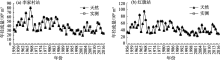
Fig. 1
Change of natural and measured annual runoff at Lijiacun and Hongqi stations"

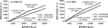
Fig. 2
Correction curve of precipitation and runoff double accumulation at Lijiacun and Hongqi stations"
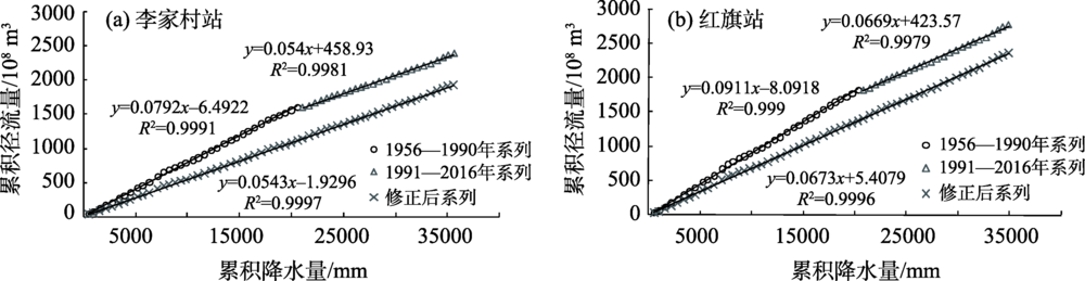
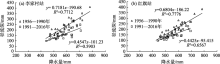
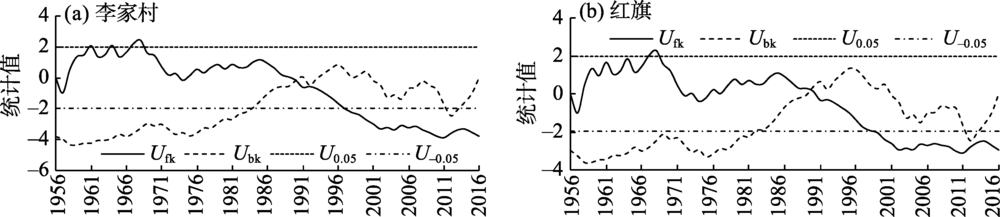
Fig. 3
Relationship between runoff depth and precipitation at Lijiacun and Hongqi stations"

Fig. 4
M-K mutation test of annual average runoff of Lijiacun and Hongqi stations in Taohe River"
Tab. 2
Correction factor of precipitation and runoff at Lijiacun and Hongqi stations"
| 降水量/mm | 李家村站 | 红旗站 | |||||
|---|---|---|---|---|---|---|---|
| y=0.7181x-190.68 | y=0.4547x-101.23 | 修正系数 | y=0.6804x-186.22 | y=0.4425x-95.41 | 修正系数 | ||
| 300 | 24.750 | 35.184 | 1.4216 | 17.90 | 37.340 | 2.0860 | |
| 350 | 60.655 | 57.919 | 0.9549 | 51.92 | 59.465 | 1.1453 | |
| 400 | 96.560 | 80.654 | 0.8353 | 85.94 | 81.590 | 0.9494 | |
| 450 | 132.465 | 103.389 | 0.7805 | 119.96 | 103.715 | 0.8646 | |
| 500 | 168.370 | 126.124 | 0.7491 | 153.98 | 125.840 | 0.8172 | |
| 550 | 204.275 | 148.859 | 0.7287 | 188.00 | 147.965 | 0.7870 | |
| 600 | 240.180 | 171.594 | 0.7144 | 222.02 | 170.090 | 0.7661 | |
| 650 | 276.085 | 194.329 | 0.7039 | 256.04 | 192.215 | 0.7507 | |
| 700 | 311.990 | 217.064 | 0.6957 | 290.06 | 214.340 | 0.7390 | |
Fig. 5
Changes of natural and current runoff at Lijiacun and Hongqi stations for many years"

Fig. 6
Yearly runoff and runoff cumulative anomaly of mainstream in Tao River Basin"
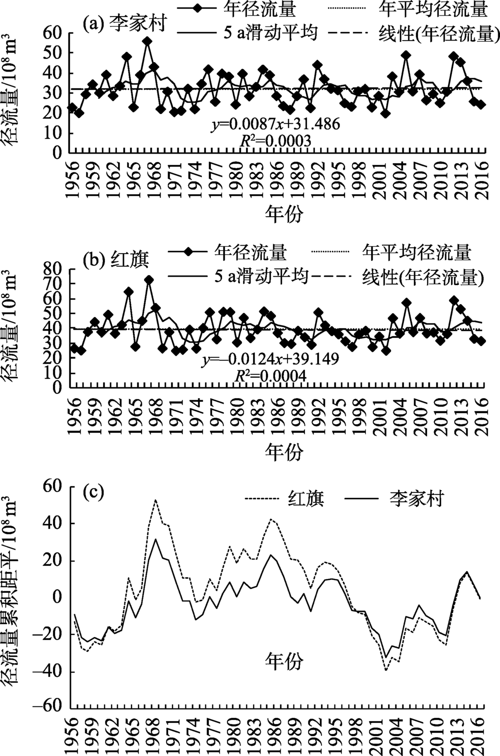
Tab. 3
Characteristic values of interannual runoff of Lijiacun and Honggi stations in Tao River Basin"
| 时段 | 平均值/108 m3 | 最大值/108 m3 | 年份 | 最小值/108 m3 | 年份 | 极值比 | 距平百分率/% | 年景 | |||||||||||||||
|---|---|---|---|---|---|---|---|---|---|---|---|---|---|---|---|---|---|---|---|---|---|---|---|
| 李家村 | 红旗 | 李家村 | 红旗 | 李家村 | 红旗 | 李家村 | 红旗 | 李家村 | 红旗 | 李家村 | 红旗 | 李家村 | 红旗 | 李家村 | 红旗 | ||||||||
| 1956—1959年 | 26.40 | 32.93 | 34.16 | 43.83 | 1959 | 1959 | 19.78 | 24.63 | 1957 | 1957 | 1.73 | 1.78 | -20.30 | -17.73 | 特枯 水年 | 偏枯水年 | |||||||
| 1960—1969年 | 36.77 | 45.17 | 55.83 | 72.20 | 1967 | 1967 | 21.76 | 26.04 | 1969 | 1969 | 2.57 | 2.77 | 13.63 | 14.17 | 偏丰 水年 | 偏丰水年 | |||||||
| 1970—1979年 | 30.44 | 37.48 | 41.65 | 50.75 | 1976 | 1978 | 20.27 | 24.40 | 1971 | 1971 | 2.05 | 2.08 | -4.34 | -3.44 | 平水 年 | 平水年 | |||||||
| 1980—1989年 | 30.62 | 38.06 | 41.61 | 50.97 | 1984 | 1984 | 21.40 | 28.95 | 1988 | 1988 | 1.94 | 1.76 | -3.72 | -1.87 | 平水 年 | 平水年 | |||||||
| 1990—1999年 | 31.28 | 35.85 | 43.92 | 50.32 | 1992 | 1992 | 22.26 | 27.08 | 1991 | 1997 | 1.97 | 1.86 | -1.53 | -8.15 | 平水 年 | 平水年 | |||||||
| 2000—2009年 | 31.31 | 38.13 | 48.78 | 56.80 | 2005 | 2005 | 19.55 | 24.54 | 2002 | 2002 | 2.50 | 2.31 | -1.44 | -1.68 | 平水 年 | 平水年 | |||||||
| 2010—2016年 | 33.45 | 40.89 | 48.24 | 58.38 | 2012 | 2012 | 24.01 | 31.02 | 2016 | 2016 | 2.01 | 1.88 | 5.05 | 5.18 | 平水 年 | 平水年 | |||||||
| 1956—2016年 | 31.76 | 38.77 | 55.83 | 72.20 | 1967 | 1967 | 19.55 | 24.40 | 2002 | 1971 | 2.86 | 2.96 | |||||||||||
| [1] | 李晓娟, 张军龙, 宋进喜, 等. 渭河陕西段径流量对经济用水的响应[J]. 干旱区地理, 2016,39(2):265-274. |
| [ Li Xiaojuan, Zhang Junlong, Song Jinxi, et al. Response of runoff to economic water consumptions of the Weihe River in Shaanxi Province[J]. Arid Land Geography, 2016,39(2):265-274. ] | |
| [2] | 牛最荣, 陈学林, 王学良. 白龙江干流代表站径流变化特征及未来趋势预测[J]. 水文, 2015,35(5):91-96. |
| [ Niu Zuirong, Chen Xuelin, Wang Xueliang. Runoff variation characteristics of representative stations on mainstream of Bailongjiang River and trend prediction[J]. Journal of China Hydrology, 2015,35(5):91-96. ] | |
| [3] | 周海鹰, 沈明希, 陈杰, 等. 塔里木河流域60a来天然径流变化趋势分析[J]. 干旱区地理, 2018,41(2):221-229. |
| [ Zhou Haiying, Sheng Mingxi, Chen Jie, et al. Trends of natural runoffs in the Tarim River Basin during the last 60 years[J]. Arid Land Geography, 2018,41(2):221-229. ] | |
| [4] | 牛最荣, 张芮, 陈学林, 等. 1970-2016年气候变化对渭河源头清源河流域降水和地表径流的影响[J]. 水土保持通报, 2018,38(5):9-14. |
| [ Niu Zuirong, Zhang Rui, Chen Xuelin, et al. Impacts of climate change on precipitation and surface runoff from 1970 to 2016 in Qingyuan River Basin, source region of Weihe River[J]. Bulletin of Soil and Water Conservation, 2018,38(5):9-14. ] | |
| [5] | 阿不力克木·阿不力孜 宋星原. 西北干旱地区径流量还原计算有关问题的探讨[J]. 节水灌溉, 2010, (8):42-44, 48. |
| [ Ablikim Abliz, Song Xingyuan. Discussion on restoring calculation of runoff in northwest arid area[J]. Water Saving Irrigation, 2010, (8):42-44, 48. ] | |
| [6] | 张洪波, 陈克宇, 俞奇骏, 等. 地下水强扰动地区的径流还原计算方法[J]. 水力发电学报, 2015,34(11):95-105. |
| [ Zhang Hongbo, Chen Keyu, Yu Qijun, et al. Unimpaired flow calculations in regions with great disturbance in groundwater[J]. Journal of Hydroelectric Engineering, 2015,34(11):95-105. ] | |
| [7] | 陆中央. 关于年径流量系列的还原计算问题[J]. 水文, 2000,20(6):9-12. |
| [ Lu Zhongyang. Restore estimation of annual runoff series[J]. Journal of China Hydrology, 2000,20(6):9-12. ] | |
| [8] | 薛树文, 曹升乐, 王利朵, 等. 年径流量序列还现方法研究[J]. 水力发电, 2017,43(5):21-24. |
| [ Xue Shuwen, Cao Shengle, Wang Liduo, et al. Research on forward restore method of annual runoff[J]. Water Power, 2017,43(5):21-24. ] | |
| [9] | 乔云峰, 夏军, 王晓红, 等. 投影寻踪法在径流还原计算中的应用研究[J]. 水力发电学报, 2007,26(1):6-10. |
| [ Qiao Yunfeng, Xia Jun, Wang Xiaohong, et al. Estimation of restoration of annual runoff series by using projection pursuit method[J]. Journal of Hydroelectric Engineering, 2007,26(1):6-10. ] | |
| [10] | 陈佳蕾, 钟平安, 刘畅, 等. 基于SWAT模型的径流还原方法研究——以大汶河流域为例[J]. 水文, 2016,36(6):28-34. |
| [ Chen Jialei, Zhong Ping’an, Liu Chang, et al. Research on runoff restoration method based on SWAT model: A case study in Dawenhe River Basin[J]. Journal of China Hydrology, 2016,36(6):28-34. ] | |
| [11] | 范辉, 肖恒, 马金一, 等. 基于VIC模型的天然径流还原研究[J]. 华北水利水电大学学报(自然科学版), 2017,38(2):7-10. |
| [ Fan Hui, Xiao Heng, Ma Jinyi, et al. Study on restoring computation of runoff based on VIC model[J]. Journal of North China University of Water Resources and Electric Power (Natural Science Edition), 2017,38(2):7-10. ] | |
| [12] | 刘强, 冯忠伦, 刘红利, 等. 结合RVA法建立天然径流量还原计算的BP神经网络模型[J]. 中国农村水利水电, 2018, (10):54-59. |
| [ Liu Qiang, Feng Zhonglun, Liu Hongli, et al. Building BP neural network model of reduction calculation combined with RVA method[J]. China Rural Water and Hydropower, 2018, (10):54-59. ] | |
| [13] | 夏传清, 马顺刚. 雅鲁藏布江中游径流还原计算方法探析[J]. 东北水利水电, 2010, (12):28-30. |
| [ Xia Chuanqing, Ma Shungang. Discussion on calculation method of runoff restore in middle reaches of Yarlung Zangbo River[J]. Water Resources & Hydropower of Northeast China, 2010, (12):28-30. ] | |
| [14] | 薛青, 张亮. 渭干河年径流量还原计算分析[J]. 水利科技与经济, 2013,19(8):34-36. |
| [ Xue Qing, Zhang Liang. Reducing the calculation of annual runoff in the Weigan River[J]. Water Conservancy Science and Technology and Economy, 2013,19(8):34-36. ] | |
| [15] | 吴英超, 吴敦银, 王永文, 等. 抚河下游李家渡站径流还原计算分析[J]. 南昌工程学院学报, 2014,33(3):14-17, 24. |
| [ Wu Yingchao, Wu Dunyin, Wang Yongwen, et al. Restoration analysis and calculation of runoff about Lijiadu station on the downstream of Fuhe River[J]. Journal of Nanchang Institute of Technology, 2014,33(3):14-17, 24. ] | |
| [16] | 孙娟绒. 坪上水库径流还现计算分析[J]. 太原理工大学学报, 2005,36(5):589-592, 596. |
| [ Sun Juanrong. Calculation analyse of current runoff in Pingshang Reservoir[J]. Journal of Taiyuan University of Technology, 2005,36(5):589-592, 596. ] | |
| [17] | 王方方, 阮燕云, 王二鹏, 等. 基于F检验的金沙江下游梯级径流还现分析研究[J]. 水电与新能源, 2018,32(9):22-25, 30. |
| [ Wang Fangfang, Ruan Yanyun, Wang Erpeng, et al. On the natural flow derivation of the downstream Jinsha River based on F-test[J]. Hydropower and New Energy, 2018,32(9):22-25, 30. ] | |
| [18] | 胡迎, 黄春长, 周亚利, 等. 黄河上游洮河流域全新世古洪水水文学研究[J]. 干旱区地理, 2017,40(5):1029-1037. |
| [ Hu Ying, Huang Chunchang, Zhou Yali, et al. Hydrological studies of the Holocene palaeoflood in the Taohe River Basin of the upper Yellow River[J]. Arid Land Geography, 2017,40(5):1029-1037. ] | |
| [19] | 杨玉霞, 郝岩彬, 化勇鹏, 等. 洮河流域水资源保护对策措施研究[J]. 甘肃水利水电技术, 2016,52(1):1-8. |
| [ Yang Yuxia, Hao Yanbin, Hua Yongpeng, et al. Study on counter measures of water resources protection in Taohe River Basin[J]. Gansu Water Resources and Hydropower Technology, 2016,52(1):1-8. ] | |
| [20] | 蒋憬. 径流还原与一致性修正在水资源评价中的应用研究——以渭河秦安站为例[J]. 地下水, 2019,41(1):181-183. |
| [ Jiang Jing. Study on the application of runoff reduction and consistency correction in water resources evaluation: Taking Qinan station of Weihe River as an example[J]. Ground Water, 2019,41(1):181-183. ] | |
| [21] | 陈凯霖, 冯民权, 王丹丹. 基于径流还原的桑干河生态基流及其盈缺分析研究[J]. 水资源与水工程学报, 2018,29(2):90-96. |
| [ Chen Kailin, Feng Minquan, Wang Dandan. Ecological basis flow and its sufficiency and lack of Sanggan River based on restoring computation of runoff[J]. Journal of Water Resources & Water Engineering, 2018,29(2):90-96. ] | |
| [22] | 商沙沙, 廉丽妹, 马婷, 等. 近54 a中国西北地区气温和降水的时空变化特征[J]. 干旱区研究, 2018,35(1):68-76. |
| [ Shang Shasha, Lian Limei, Ma Ting, et al. Spatiotemporal variation of temperature and precipitation in northwest China in recent 54 years[J]. Arid Zone Research, 2018,35(1):68-76. ] | |
| [23] | 孙栋元, 齐广平, 鄢继选, 等. 疏勒河干流降水变化特征[J]. 干旱区研究, 2020,37(2):291-303. |
| [ Sun Dongyuan, Qi Guanping, Yan Jixuan, et al. Research on variation characteristics of precipitation in the mainstream of Shule River[J]. Arid Zone Research, 2020,37(2):291-303. ] | |
| [24] | 热孜宛古丽·麦麦提依明, 杨建军, 刘巍. 艾比湖流域1957-2013年潜在蒸散、气温、降水变化特征分析[J]. 冰川冻土, 2016,38(1):69-76. |
| [ Reziwangguili Maimaitiyiming, Yang Jianjun, Liu Wei. Changing characteristics of potential evapotranspiration, air temperature and precipitation in Ebinur Lake Basin from 1957 to 2013[J]. Journal of Glaciology and Ceocryology, 2016,38(1):69-76. ] | |
| [25] | 周唤唤, 郭威. 芜湖市1971—2015年降水变化趋势及突变性分析[J]. 黄河水利职业技术学院学报, 2018,30(1):5-10. |
| [ Zhou Huanhuan, Guo Wei. Rainfall change trend and mutation analysis in Wuhu from 1971 to 2015[J]. Journal of Yellow River Conservancy Technical Institute, 2018,30(1):5-10. ] | |
| [26] | 常周梅, 胡文博, 张丽娟. 西宁市1951—2015年气温及降水量变化特征[J]. 水电能源科学, 2017,35(2):7-11. |
| [ Chang Zhoumei, Hu Wenbo, Zhang Lijuan. Change characteristics of temperature and precipitation from 1951 to 2015 in Xining City[J]. Water Resources and Power, 2017,35(2):7-11. ] | |
| [27] | 刘艳伟, 王淑莹, 屠星磊, 等. 元谋干热河谷区近60年干湿状况和气温变化特征分析[J]. 排灌机械工程学报, 2018,36(2):172-178. |
| [ Liu Yanwei, Wang Shuying, Tu Xinglei, et al. Characteristic analysis of dry-wet condition and temperature trend in Yuanmou dry-hot valley (DHV) in recent 60 years[J]. Journal of Drainage and Irrigation Machinery Engineering, 2018,36(2):172-178. ] | |
| [28] | 高彦春, 王金凤, 封志明. 白洋淀流域气温、降水和径流变化特征及其相互响应关系[J]. 中国生态农业学报, 2017,25(4):467-477. |
| [ Gao Yanchun, Wang Jinfeng, Feng Zhiming. Variation trend and response relationship of temperature, precipitation and runoff in Baiyangdian Lake Basin[J]. Chinese Journal of Eco-Agriculture, 2017,25(4):467-477. ] |
| [1] | WANG Xueliang, CHEN Rensheng, LIU Junfeng, CAO Shanshan. Characteristics of flood changes in mountainous areas of upper Shule River from 1956 to 2021 [J]. Arid Land Geography, 2023, 46(8): 1260-1268. |
| [2] | ZHANG Yongjun, YANG Yuhui, HU Yicheng, FENG Xiancheng, YANG Jingyan. Temporal and spatial variation characteristics of hydrochemistry and irrigation adaptability evaluation in Kashi River Basin, Xinjiang [J]. Arid Land Geography, 2023, 46(4): 583-594. |
| [3] | ZHOU Dan, BAO Guangyu, SU Xianfeng, WANG Li, LI Baohua. Spatiotemporal variation characteristics of sunshine hours in Qinghai Plateau from 1961 to 2020 [J]. Arid Land Geography, 2023, 46(1): 36-46. |
| [4] | CAO Yanchao,JIAO Meiling,QIN Tuo,GUO Tong. Variation characteristics and influencing factors of summer half-year precipitation in Hedong region of Gansu Province from 1973 to 2020 [J]. Arid Land Geography, 2022, 45(6): 1695-1706. |
| [5] | Aierken TUERSUN,Yusufujiang RUSULI,CUI Yishuang,Kadiayi ALIMU,Miriayi MAITUDI. Temporal and spatial variations of lake ice phenology in large lakes of Xinjiang from 2000 to 2019 [J]. Arid Land Geography, 2022, 45(5): 1440-1449. |
| [6] | CHENG Yi,WU Lanzhen,LIU Fenggui,SHEN Yanjun. Changes of runoff and precipitation in the upstream of Yellow River during the past 60 years [J]. Arid Land Geography, 2022, 45(4): 1022-1031. |
| [7] | YANG Mei,LI Yanying,ZHANG Chunyan,YANG Jiping,LUO Xiaoling,NIE Xin. Variation characteristics of spring sandstorm and its typical case analysis in the middle east of Hexi Corridor [J]. Arid Land Geography, 2021, 44(5): 1339-1349. |
| [8] |
LIU Quan-yang, QI Ming-liang, MA Xiao-zhou, GONG Juan-xiao.
SWAT simulation and countermeasures of non-point source-pollution based on remote sensing and GIS in Taohe River Basin [J]. Arid Land Geography, 2020, 43(3): 706-714. |
| [9] | SUN Dong-yuan, QI Guang-ping, MA Yan-lin, YAN Ji-xuan, WU Lan-zhen, KAN Yan-xia. Variation characteristics of runoff in the mainstream of Shule River [J]. Arid Land Geography, 2020, 43(3): 557-567. |
| [10] | WANG Feng-jiao, LIANG Wei, FU Bo-jie, JIN Zhao, YAN Na-na. Spatial and temporal changes of cultivated land and quantitative analysis of ration safe cultivated land on the Loess Plateau in recent years [J]. Arid Land Geography, 2020, 43(1): 161-171. |
| [11] | GAO Yulian, LIU Jinbao, LIU Weiyang, YU Jing, LIU Zhihong. Spatiotemporal variation characteristics of surface evapotranspiration anddrought at the oasis area of the southern Xinjiang in recent 14 years [J]. Arid Land Geography, 2019, 42(4): 830-837. |
| [12] | JIANG Hui-min, LIU Chun-yun, JIA Jian, LU Guang-hui, ZHAO De-long. Characteristics and causes of meteorological drought in summer in Urumqi [J]. 干旱区地理, 2018, 41(4): 693-700. |
| [13] | ZHOU Hai-ying, SHEN Ming-xi, CHEN Jie, XIA Jun, HONG Si. Trends of natural runoffs in the Tarim River Basin during the last 60 years [J]. 干旱区地理, 2018, 41(2): 221-229. |
| [14] | DING Wen-kui, YANG Xiao-ling, WANG Zuo-cheng, YUE Ping. Variation characteristics of low temperature Events in East of Hexi Corridor [J]. 干旱区地理, 2018, 41(1): 17-24. |
| Viewed | ||||||||||||||||||||||||||||||||||||||||||||||||||
|
Full text 880
|
|
|||||||||||||||||||||||||||||||||||||||||||||||||
|
Abstract 352
|
|
|||||||||||||||||||||||||||||||||||||||||||||||||
Cited |
|
|||||||||||||||||||||||||||||||||||||||||||||||||
| Shared | ||||||||||||||||||||||||||||||||||||||||||||||||||
|
||