干旱区地理 ›› 2021, Vol. 44 ›› Issue (5): 1350-1364.doi: 10.12118/j.issn.1000–6060.2021.05.16
李海娟( ),刘时银(),吴坤鹏
收稿日期:2020-10-12
修回日期:2021-03-05
出版日期:2021-09-25
发布日期:2021-09-22
通讯作者:
刘时银
作者简介:李海娟(1995-),女,硕士研究生,主要从事冰川遥感研究. E-mail: 基金资助:
LI Haijuan(),LIU Shiyin(),WU Kunpeng
Received:2020-10-12
Revised:2021-03-05
Online:2021-09-25
Published:2021-09-22
Contact:
Shiyin LIU
摘要:
利用ITS_LIVE数据、Landsat数据提取了喀喇昆仑山北坡42条冰川的表面流速。将末端运动与表面运动特征结合起来,分析对比了不同运动类型冰川表面流速的时空变化。结果表明:(1) 1989-2018年,研究区42条冰川中,存在稳定冰川16条、前进冰川6条、退缩冰川1条、跃动冰川19条。空间上,流速分布符合冰川运动一般原理,可在积累区和冰舌上部发现明显的高值区域,这些区域多出现在跃动冰川主干或支部,流速大小一般在100.00 m·a-1之上,如在音苏盖提冰川南分支,其最大流速可达到358.33 m·a-1。(2) 冰川流速分布与地形要素的关系密切。流速在海拔4600~5000 m之间达到最大(54.55 m·a-1),是冰川末端流速的10倍以上;分布在坡度0~5°之间的42条冰川平均流速最大,并且随着坡度的增大,流速逐渐减小;处于东向的冰川流速最大,处于西南向的流速最小。(3) 稳定冰川流速年际变化较稳定,不同年份相同位置的流速值较一致;而对于前进冰川和退缩冰川而言,年际流速波动均较大;跃动冰川不同位置年际流速变化不同。末端发生前进的跃动冰川表面流速变化不大,但末端变化速度却可超过100.00 m·a-1,甚至可达到500.00 m·a-1。(4) 长度更长、面积更大的冰川易发生跃动。气候、雪崩和地形也是影响冰川运动速度变化的主要原因。
李海娟,刘时银,吴坤鹏. 喀喇昆仑山乔戈里峰北坡主要冰川运动特征[J]. 干旱区地理, 2021, 44(5): 1350-1364.
LI Haijuan,LIU Shiyin,WU Kunpeng. Characteristics of major glacial movements on the northern slope of K2, Karakoram[J]. Arid Land Geography, 2021, 44(5): 1350-1364.

图1
喀喇昆仑山北坡冰川概况图 注:图中数字0~41代表冰川序号。"
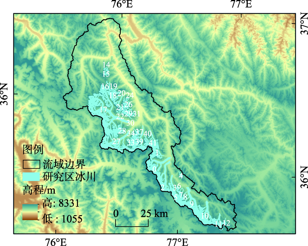
表1
遥感影像数据列表"
| 序号 | 日期(年-月-日) | 传感器 | 云量 | 序号 | 日期(年-月-日) | 传感器 | 云量 |
|---|---|---|---|---|---|---|---|
| 1 | 1989-11-17 | TM | 10.18 | 14 | 2004-08-14 | ETM+ | 1.30 |
| 2 | 1992-11-25 | TM | 18.74 | 15 | 2005-09-02 | ETM+ | 6.94 |
| 3 | 1991-08-19 | TM | 18.87 | 16 | 2006-10-07 | ETM+ | 2.72 |
| 4 | 1993-07-07 | TM | 1.00 | 17 | 2007-04-17 | ETM+ | 2.67 |
| 5 | 1994-06-24 | TM | 5.21 | 18 | 2008-06-06 | ETM+ | 1.99 |
| 6 | 1996-09-01 | TM | 17.60 | 19 | 2009-08-12 | ETM+ | 1.84 |
| 7 | 1997-07-18 | TM | 0.83 | 20 | 2010-10-18 | ETM+ | 2.77 |
| 8 | 1998-04-16 | TM | 0.00 | 21 | 2011-08-02 | ETM+ | 31.64 |
| 9 | 1999-01-13 | TM | 0.00 | 22 | 2013-10-10 | ETM+ | 2.17 |
| 10 | 2000-06-16 | TM | 2.00 | 23 | 2014-06-15 | OLI | 8.84 |
| 11 | 2001-05-18 | TM | 2.00 | 24 | 2015-01-09 | OLI | 11.20 |
| 12 | 2002-10-12 | TM | 3.00 | 25 | 2016-09-24 | OLI | 13.38 |
| 13 | 2003-05-08 | ETM+ | 2.00 | 26 | 2018-04-07 | OLI | 2.75 |
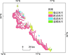
图2
跃动冰川、前进冰川、退缩冰川和稳定冰川的空间分布"


图3
冰川表面流速分布"
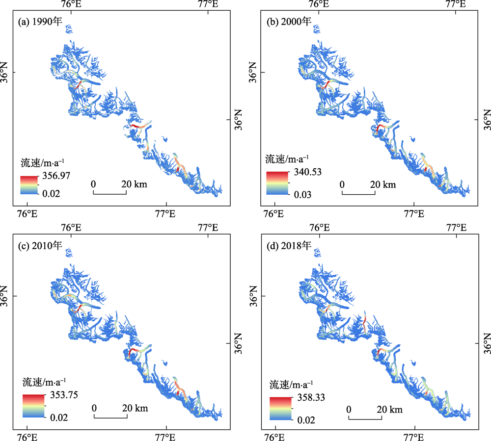
图4
不同地形参数的冰川流速"

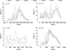
图5
稳定冰川不同年际中流线流速"
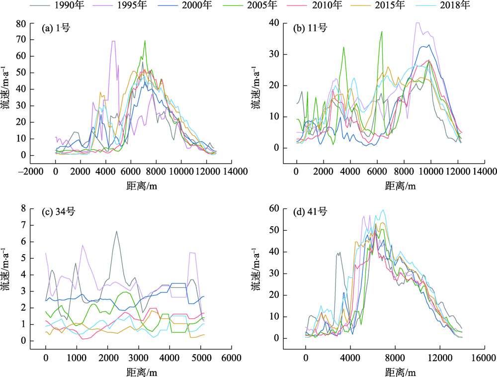
图6
前进冰川不同年际中流线流速"
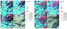
图7
典型冰川前进现象"

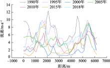
图8
退缩冰川12号冰川不同年际中流线流速"

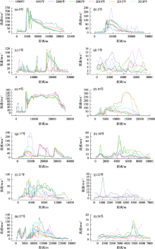
图9
跃动冰川不同年际中的流线流速(冰川序号:0、2、5、7、9、10、17、18、21、22、27、28)"
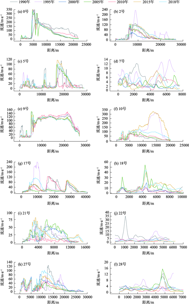
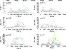
图10
跃动冰川不同年际中的流线流速(冰川序号:29、30、31、37、39、40)"

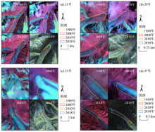
图11
典型冰川跃动现象"

表2
选取的典型冰川基本信息表"
| 冰川编号 | 冰川编码 | 坡向 | 面积/km2 | 长度/km | 平均高程/m | 平均流速/m·a-1 | 冰川类型 |
|---|---|---|---|---|---|---|---|
| 0 | 5Y654C0163 | NE | 107.74 | 21.98 | 5670.75 | 32.82 | 跃动 |
| 1 | 5Y654C0167 | E | 32.25 | 13.83 | 5587.68 | 6.38 | 稳定 |
| 2 | 5Y654C0157 | NE | 87.83 | 26.91 | 5358.23 | 25.30 | 跃动 |
| 3 | 5Y654C0136 | N | 1.71 | 3.22 | 5488.77 | 1.66 | 稳定 |
| 4 | 5Y654C0045 | NW | 6.14 | 5.89 | 5793.50 | 3.53 | 前进 |
| 5 | 5Y654C0145 | N | 83.82 | 28.83 | 5519.46 | 13.73 | 跃动 |
| 6 | 5Y654C0135 | NE | 2.03 | 3.54 | 5572.33 | 2.74 | 稳定 |
| 7 | 5Y654C0132 | NE | 10.00 | 8.42 | 5574.76 | 3.32 | 跃动 |
| 8 | 5Y654C0130 | NE | 6.16 | 8.72 | 5537.67 | 2.70 | 稳定 |
| 9 | 5Y654C0128 | N | 110.35 | 26.42 | 5617.93 | 38.80 | 跃动 |
| 10 | 5Y654C0116 | NE | 94.43 | 20.12 | 5664.67 | 35.05 | 跃动 |
| 11 | 5Y654C0092 | N | 39.53 | 14.53 | 5699.06 | 7.86 | 稳定 |
| 12 | 5Y654C0087 | NE | 6.93 | 6.81 | 5807.98 | 3.54 | 退缩 |
| 13 | 5Y654D0123 | NE | 2.34 | 4.29 | 5534.80 | 1.78 | 稳定 |
| 14 | 5Y654D0122 | N | 2.72 | 3.19 | 5458.10 | 2.45 | 稳定 |
| 15 | 5Y654D0119 | NE | 7.43 | 5.44 | 5507.69 | 2.64 | 稳定 |
| 16 | 5Y654D0112 | NE | 9.64 | 8.15 | 5443.55 | 7.30 | 稳定 |
| 17 | 5Y654D0053 | E | 359.05 | 43.16 | 5377.05 | 21.18 | 跃动 |
| 18 | 5Y654D0097 | E | 19.80 | 11.37 | 5660.93 | 8.24 | 跃动 |
| 19 | 5Y654D0105 | NE | 10.16 | 6.58 | 5529.76 | 5.05 | 前进 |
| 20 | 5Y654D0102 | NE | 5.92 | 5.98 | 5597.82 | 2.57 | 前进 |
| 21 | 5Y654D0096 | N | 27.55 | 15.10 | 5418.99 | 9.69 | 跃动 |
| 22 | 5Y654D0064 | S | 8.17 | 6.85 | 5756.31 | 1.38 | 跃动 |
| 23 | 5Y654D0092 | NE | 2.41 | 4.86 | 5686.01 | 2.57 | 稳定 |
| 24 | 5Y654D0089 | NE | 3.78 | 5.05 | 5596.15 | 2.32 | 稳定 |
| 25 | 5Y654D0066 | S | 1.76 | 3.76 | 5712.78 | 1.11 | 前进 |
| 26 | 5Y654D0087 | NE | 12.20 | 6.46 | 5519.86 | 9.04 | 前进 |
| 27 | 5Y654D0048 | NE | 182.54 | 27.91 | 5450.89 | 16.95 | 跃动 |
| 28 | 5Y654D0048 | E | 8.54 | 8.08 | 5509.20 | 2.56 | 跃动 |
| 29 | 5Y654D0077 | NE | 11.92 | 7.65 | 5524.96 | 2.88 | 跃动 |
| 30 | 5Y654D0068 | SE | 10.09 | 10.64 | 5792.27 | 4.39 | 跃动 |
| 31 | 5Y654D0073 | N | 3.26 | 5.15 | 5569.96 | 1.29 | 稳定 |
| 32 | 5Y654D0072 | NE | 2.41 | 4.57 | 5503.74 | 0.64 | 稳定 |
| 33 | 5Y654D0033 | NW | 11.14 | 7.03 | 5826.72 | 5.42 | 跃动 |
| 34 | 5Y654D0032 | NW | 4.50 | 5.54 | 5945.17 | 1.25 | 稳定 |
| 35 | 5Y654D0027 | N | 3.37 | 5.53 | 5660.38 | 1.67 | 前进 |
| 36 | 5Y654D0026 | NW | 2.13 | 4.46 | 5849.63 | 0.95 | 稳定 |
| 37 | 5Y654D0023 | NW | 3.43 | 6.34 | 5475.77 | 1.92 | 跃动 |
| 38 | 5Y654D0022 | N | 1.73 | 3.87 | 5438.58 | 1.45 | 稳定 |
| 39 | 5Y654D0016 | NE | 74.68 | 21.31 | 5778.15 | 31.95 | 跃动 |
| 40 | 5Y654D0016 | N | 16.44 | 12.74 | 5721.73 | 7.57 | 跃动 |
| 41 | 无 | N | 38.03 | 15.37 | 5511.19 | 11.29 | 稳定 |
| [1] |
段建平, 王丽丽, 任贾文, 等. 近百年来中国冰川变化及其对气候变化的敏感性研究进展[J]. 地理科学进展, 2009, 28(2):231-237.
doi: 10.11820/dlkxjz.2009.02.010 |
|
[ Duan Jianping, Wang Lili, Ren Jiawen, et al. Progress in glacier variations in China and its sensitivity to climatic change during the past century[J]. Advances in Earth Science, 2009, 28(2):231-237. ]
doi: 10.11820/dlkxjz.2009.02.010 |
|
| [2] | 王聪强, 杨太保, 冀琴, 等. 1988-2013年布加岗日地区冰川变化及其对气候变化的响应[J]. 水土保持研究, 2016, 23(4):70-76. |
| [ Wang Congqiang, Yang Taibao, Ji Qin, et al. Variation of glacier and its response to climate change in the Bujiagangri region from 1988 to 2013[J]. Resarch of Soil and Water Consearvation, 2016, 23(4):70-76. ] | |
| [3] | 秦艳, 杨太保, 冀琴, 等. 1973-2016年哈尔里克山现代冰川变化分析[J]. 兰州大学学报(自然科学版), 2018, 54(5):569-576. |
| [ Qing Yan, Yang Taibao, Ji Qin, et al. Changes in the modern glaciers of Harlik Mountains from 1973-2016[J]. Journal of Lanzhou University (Natural Sciences), 2018, 54(5):569-576. ] | |
| [4] | 王晶, 杨太保, 冀琴, 等. 1990-2015年喜马拉雅山东段中国和不丹边境地区冰川变化研究[J]. 干旱区地理, 2019, 42(3):542-550. |
| [ Wang Jing, Yang Taibao, Ji Qin, et al. Change of modern glaciers in the eastern Himalaya near China and Bhutan border area from 1990 to 2015[J]. Arid Land Geography, 2019, 42(3):542-550. ] | |
| [5] | 叶庆华, 程维明, 赵永利, 等. 青藏高原冰川变化遥感监测研究综述[J]. 地球信息科学学报, 2016, 18(7):920-930. |
| [ Ye Qinghua, Cheng Weiming, Zhao Yongli, et al. A review on research of glacier changes on the Tibetan Plateau by remote sensing technologies[J]. Journal of Geo-Information Science, 2016, 18(7):920-930. ] | |
| [6] | 井哲帆, 刘力, 周在明, 等. 冰川运动速度影响因子的强度分析--以祁连山七一冰川为例[J]. 冰川冻土, 2011, 33(6):1222-1228. |
| [ Jing Zhefan, Liu Li, Zhou Zaiming, et al. Analysis on the influencing factors of glacier flow velocity: A case study of Qiyi glacier in the Qilian Mountains[J]. Journal of Glaciology and Geocryology, 2011, 33(6):1222-1228. ] | |
| [7] | 井哲帆, 周在明, 刘力. 中国冰川运动速度研究进展[J]. 冰川冻土, 2010, 32(4):749-754. |
| [ Jing Zhefan, Zhou Zaiming, Liu Li, et al. Progress of the research on glacier velocity in China[J]. Journal of Glaciology and Geocryology, 2010, 32(4):749-754. ] | |
| [8] | 周在明, 井哲帆, 赵淑惠, 等. 冰川运动速度对气候变化的响应--以天山乌鲁木齐河源1号冰川为例[J]. 地球学报, 2010, 31(2):237-244. |
| [ Zhou Zaiming, Jing Zhefan, Zhao Shuhui, et al. The response of glacier velocity to climate change: A case study of Urumqi glacier No.1[J]. Journal of Earth Science, 2010, 31(2):237-244. ] | |
| [9] | 井哲帆, 叶柏生, 焦克勤, 等. 天山奎屯河哈希勒根51号冰川表面运动特征分析[J]. 冰川冻土, 2002, 24(5):563-566. |
| [ Jing Zhefan, Ye Baisheng, Jiao Keqin, et al. Surface velocity on the glacier No.51 at Haxilegen of the Kuytun River, Tianshan Mountains[J]. Journal of Glaciology and Geocryology, 2002, 24(5):563-566. ] | |
| [10] | 曹泊, 王杰, 潘保田, 等. 祁连山东段宁缠河1号冰川和水管河4号冰川表面运动速度研究[J]. 冰川冻土, 2013, 35(6):1428-1435. |
| [ Cao Bo, Wangjie, Pan Baotian, et al. Surface flow velocity of Ningchanhe No.1 and Shuiguanhe No.4 glaciers in the east Qilian Moutains[J]. Journal of Glaciology and Geocryology, 2013, 35(6):1428-1435. ] | |
| [11] | 刘宇硕, 秦翔, 杜文涛, 等. 祁连山冷龙岭宁缠河3号冰川表面流速特征分析[J]. 冰川冻土, 2013, 35(4):834-840. |
| [ Liu Yushuo, Qin Xiang, Du Wentao, et al. An analysis of flow features of the Ningchan River glacier No.3 in the Qilian Mountains[J]. Journal of Glaciology and Geocryology, 2013, 35(4):834-840. ] | |
| [12] | 王仕哲, 柯长青. 基于特征跟踪方法的喜马拉雅山冬季冰川流速估算[J]. 高技术通讯, 2018, 28(3):257-268. |
| [ Wang Shizhe, Ke Changqing. Estimation of the Himalayas’ winter glacier velocity based on feature tracking[J]. High Technology Letter, 2018, 28(3):257-268. ] | |
| [13] | 王欣, 刘琼欢, 蒋亮虹, 等. 基于SAR影像的喜马拉雅山珠穆朗玛峰地区冰川运动速度特征及其影响因素分析[J]. 冰川冻土, 2015, 37(3):570-579. |
| [ Wang Xin, Liu Qionghuan, Jiang Lianghong, et al. Charateristics and influence factors of glacier surface flow velocity in the Everest region, the Himalayas derived from AlOS/PALSAR images[J]. Journal of Glaciology and Geocryology, 2015, 37(3):570-579. ] | |
| [14] | 王仕哲, 柯长青. 基于ALO SPALSAR的喜马拉雅山冰川流速分布及变化[J]. 遥感技术与应用, 2018, 33(5):942-955. |
| [ Wang Shizhe, Ke Changqing. Distribution and variation of glacier velocity in Himalayas based on ALOS PALSAR[J]. Remote Sensing Technology and Application, 2018, 33(5):942-955. ] | |
| [15] |
Sam L, Bhardwaj A, Kumar R, et al. Heterogeneity in topographic control on velocities of western Himalayan glaciers[J]. Scientific Reports, 2018, 8(1):12843, doi: 10.1038/s41598-018-31310-y.
doi: 10.1038/s41598-018-31310-y |
| [16] |
Kumar V, Venkataramana G, Høgda K A. Glacier surface velocity estimation using SAR interferometry technique applying ascending and descending passes in Himalayas[J]. International Journal of Applied Earth Observation and Geoinformation, 2011, 13(4):545-551.
doi: 10.1016/j.jag.2011.02.004 |
| [17] | 王仕哲. 青藏高原冰川流速估算[D]. 南京: 南京大学, 2019. |
| [ Wang Shizhe. Estimation of glacier velocity over Tibetan Plateau[D]. Nanjing: Nanjing University, 2019. ] | |
| [18] | 孙作哲. 喀喇昆仑山区的冰川运动速度测量[J]. 冰川冻土, 1979, 1(2):33-38, 51. |
| [ Sun Zuozhe. Measurement of glacier velocity in the Karakoram Mountains[J]. Journal of Glaciology and Geocryology, 1979, 1(2):33-38, 51. ] | |
| [19] | 张莎莎, 张震, 刘时银, 等. 喀喇昆仑山西北部冰川运动速度地形控制特征[J]. 冰川冻土, 2019, 41(5):1015-1025. |
| [ Zhang Shasha, Zhang Zhen, Liu Shiyin, et al. Topographic control characteristics of glacier velocity in Hunza River Basin of Karakoram Mountains[J]. Journal of Glaciology and Geocryology, 2019, 41(5):1015-1025. ] | |
| [20] | Sun Y L, Jiang L M, Liu L, et al. Spatial-temporal characteristics of glacier velocity in the central Karakoram revealed with 1999-2003 Landsat-7 ETM+ pan images[J]. Remote Sensing, 2017, 9(10):1-20. |
| [21] | 刘凯, 王宁练, 白晓华. 1993-2015年喀喇昆仑山努布拉流域冰川变化遥感监测[J]. 冰川冻土, 2017, 39(4):710-719. |
| [ Liu Kai, Wang Ninglian, Bai Xiaohua. Variation of glacier in the Nubra Basin, Karakoram Mountains, revealed by remote sensing images during 1993-2015[J]. Journal of Glaciology and Geocryology, 2017, 39(4):710-719. ] | |
| [22] | Rankl M, Kienholz C, Braun M. Glacier changes in the Karakoram region mapped by multimission satellite imagery[J]. 2014, 8(3):977-989. |
| [23] |
许艾文, 杨太保, 王聪强, 等. 1978-2015年喀喇昆仑山克勒青河流域冰川变化的遥感监测[J]. 地理科学进展, 2016, 35(7):878-888.
doi: 10.18306/dlkxjz.2016.07.009 |
|
[ Xu Aiwen, Yang Taibao, Wang Congqiang, et al. Variation of glaciers in the Shaksgam River Basin, Karakoram Mountains during 1978-2015[J]. Advances in Earth Science, 2016, 35(7):878-888. ]
doi: 10.18306/dlkxjz.2016.07.009 |
|
| [24] | 许艾文, 杨太保, 冀琴, 等. 乔戈里峰北坡冰川跃动遥感监测[J]. 兰州大学学报(自然科学版), 2016, 52(2):145-152. |
| [ Xu Aiwen, Yang Taibao, Ji Qin, et al. Monitoring recent surging on the northern slope glaciers of Qogir through remote sensing[J]. Journal of Lanzhou University (Natural Sciences), 2016, 52(2):145-152. ] | |
| [25] |
Quincey D J, Braun M, Glasser N F, et al. Karakoram glacier surge dynamics[J]. Geophysical Research Letters, 2011, 38(18), doi: 10.1029/2011GL049004.
doi: 10.1029/2011GL049004 |
| [26] |
Duncan J Q, Neil F G, Simon J C, et al. Heterogeneity in Karakoram glacier surges[J]. Journal of Geophysical Research: Earth Surface, 2015, 120(7):1288-1300.
doi: 10.1002/2015JF003515 |
| [27] |
Farinotti D, Walter W I, Remco J de K, et al. Manifestations and mechanisms of the Karakoram glacier anomaly[J]. Nature Geoscience, 2020, 13(1):8-16.
doi: 10.1038/s41561-019-0513-5 pmid: 31915463 |
| [28] |
Mayer C, Fowler A C, Lambrecht A, et al. A surge of north Gasherbrum glacier, Karakoram, China[J]. Journal of Glaciology, 2011, 57(205):904-916.
doi: 10.3189/002214311798043834 |
| [29] | Ding M H, Huai B J, Sun W J, et al. Surge-type glaciers in Karakoram Mountain and possible catastrophes alongside a portion of the Karakoram Highway[J]. Natural Hazards, 2018, 90(2):1017-1020. |
| [30] |
Bhambri R, Hewitt K, Kawishwar P, et al. Surge-type and surge-modified glaciers in the Karakoram[J]. Scientific Reports, 2017, 7(221):332-340.
doi: 10.1038/s41598-017-00471-7 |
| [31] | 康建成, 何元庆. 喀喇昆仑山克勒青河上游地区冰川的初步探究[J]. 冰川冻土, 1990, 12(4):319-325. |
| [ Kang Jiancheng, He Yuanqing. The preliminary study on existing glaciers located in the upper region of Saksgam River, Karakoram Mountains[J]. Journal of Glaciology and Geocryology, 1990, 12(4):319-325. ] | |
| [32] |
Haireti A, Tateishi R, Alsaaideh B. Multi-criteria technique for mapping of debris-covered and clean-ice glaciers in the Shaksgam Valley using Landsat TM and ASTER GDEM[J]. Journal of Mountain Science, 2016, 13(4):703-714.
doi: 10.1007/s11629-015-3649-9 |
| [33] | 康建成, 何元庆. 喀喇昆仑山克勒青河谷冰川冰岩界面特征的初步研究[J]. 冰川冻土, 1991, 13(4):331-336. |
| [ Kang Jiancheng, He Yuanqing. Characteristic at boundary face of ice-bedrock on the upper region of Shaksgam Valley, Karakoram[J]. Journal of Glaciology and Geocryology, 1991, 13(4):331-336. ] | |
| [34] | 孙永玲, 江利明, 柳林, 等. 基于Landsat-7 ETM+SLC-OFF影像的山地冰川流速提取与评估--以Karakoram锡亚琴冰川为例[J]. 冰川冻土, 2016, 38(3):596-603. |
| [ Sun Yongling, Jiang Liming, Liu Lin, et al. Surface flow velocity of mountain glacier derived from Landsat-7 ETM+SLC-OFF images: Extraction and quantitative evaluation: A case study of the Siachen glacier in the Karakoram[J]. Journal of Glaciology and Geocryology, 2016, 38(3):596-603. ] | |
| [35] | Gardner A S, Fahnstock M S, Cambos T. ITS_LIVE regional glacier and ice sheet surface velocities[EB/OL]. [2021-03-04]. https://its-live.jpl.nasa.gov. |
| [36] | 陈杰, 杨太保, 冀琴, 等. 1976-2014年爬努河流域冰川变化对气候变化的响应[J]. 干旱区资源与环境, 2015, 29(9):171-175. |
| [ Chen Jie, Yang Taibao, Ji Qin, et al. Glacier in response to climate change in the Panuhe Basin, Tibet from 1976 to 2014[J]. Journal of Arid Land Resources and Environment, 2015, 29(9):171-175. ] | |
| [37] | 吴坤鹏, 刘时银, 鲍伟佳, 等. 1980-2015年青藏高原东南部岗日嘎布山冰川变化的遥感监测[J]. 冰川冻土, 2017, 39(1):24-34. |
| [ Wu Kunpeng, Liu Shiyin, Bao Weijia, et al. Remote sensing monitoring of the glacier change in the Gangrigabu Range, southeast Tibetan Plateau from 1980 through 2015[J]. Journal of Glaciology and Geocryology, 2017, 39(1):24-34. ] | |
| [38] | 胡凡盛, 杨太保, 冀琴, 等. 近25 a布喀达坂峰冰川变化与气候的响应[J]. 干旱区地理, 2018, 41(1):66-73. |
| [ Hu Fansheng, Yang Taibao, Ji Qin, et al. Response of glacier in the Bukatage Mountains to climate change from 1990 to 2015[J]. Arid Land Geography, 2018, 41(1):66-73. ] | |
| [39] |
何毅, 杨太保, 陈杰, 等. 1972-2013年东天山博格达峰地区冰川变化遥感监测[J]. 地理科学, 2015, 35(7):925-932.
doi: 10.13249/j.cnki.sgs.2015.07.925 |
|
[ He Yi, Yang Taibao, Chen Jie. Remote sensing detection of glacier changes in Dong Tianshan Bogda region in 1972-2013[J]. Earth Science, 2015, 35(7):925-932. ]
doi: 10.13249/j.cnki.sgs.2015.07.925 |
|
| [40] | 何毅, 闫浩文, 杨宇雷, 等. 近期哈尔里克山脉冰川变化遥感监测[J]. 干旱区地理, 2018, 41(2):358-366. |
| [ He Yi, Yan Haowen, Yang Yulei, et al. Dynamic monitoring of glacier change in Hal Rick Mountain[J]. Arid Land Geography, 2018, 41(2):358-366. ] | |
| [41] |
刘娟, 姚晓军, 刘时银, 等. 1970-2016年冈底斯山冰川变化[J]. 地理学报, 2019, 74(7):1333-1344.
doi: 10.11821/dlxb201907005 |
|
[ Liu Juan, Yao Xiaojun, Liu Shiyin, et al. Glacier changes in the Gangdisê Mountains from 1970 to 2016[J]. Acta Geographica Sinica, 2019, 74(7):1333-1344. ]
doi: 10.11821/dlxb201907005 |
|
| [42] | 牛生明, 李忠勤, 怀保娟. 遥感影像提取冰川信息方法研究[J]. 中国西部科技, 2014, 13(8):1-3. |
| [ Niu Shengming, Li Zhongqin, Huai Baojuan. Study on the remote sensing image extraction methods in glaciers area[J]. Science and Technology of West, 2014, 13(8):1-3. ] | |
| [43] |
Lü M Y, Guo H D, Lu X C, et al. Characterizing the behaviour of surge-and non-surge-type glaciers in the Kingata Mountains, eastern Pamir, from 1999 to 2016[J]. The Cryosphere, 2019, 13(1):219-236.
doi: 10.5194/tc-13-219-2019 |
| [44] | 张震, 刘时银, 魏俊锋, 等. 新疆帕米尔跃动冰川遥感监测研究[J]. 冰川冻土, 2016, 38(1):11-20. |
| [ Zhang Zhen, Liu Shiyin, Wei Junfeng, et al. Monitoring recent surging of Karayaylak glacier in Pamir by remote sensing[J]. Journal of Glaciology and Geocryology, 2016, 38(1):11-20. ] | |
| [45] |
Grant K L, Stokes C R, Evans I S. Identification and characteristics of surge-type glaciers on Novaya Zemlya, Russian Arctic[J]. Journal of Glaciology, 2009, 55(194):960-972.
doi: 10.3189/002214309790794940 |
| [46] |
Lü M Y, Guo H D, Yan J, et al. Distinguishing glaciers between surging and advancing by remote sensing: A case study in the eastern Karakoram[J]. Remote Sensing, 2020, 12:2297, doi: 10.3390/rs12142297.
doi: 10.3390/rs12142297 |
| [47] | 韩艳飞. 基于Landsat遥感影像的西昆仑冰川变化监测与流速估算研究(1977-2013)[D]. 南京: 南京大学, 2015. |
| [ Han Yanfei. Research on glacier change in the west Kunlun Mountains and flow velocity estimation based on landsat images (1977-2013)[D]. Nanjing: Nanjing University, 2015. ] | |
| [48] | 张聪, 姚晓军, 张大弘. 2016年阿尔金山冰川边界及长度数据集[J]. 中国科学数据(中英文网络版), 2020, 5(2):166-175. |
| [ Zhang Cong, Yao Xiaojun, Zhang Dahong. A dataset of boundary and length of glaciers in the Altun Mountains in 2016[J]. Scientific Data in China (Chinese and English online), 2020, 5(2):166-175. ] | |
| [49] | 许艾文. 近40年中国喀喇昆仑山冰川变化的遥感监测[D]. 兰州: 兰州大学, 2017. |
| [ Xu Aiwen. Monitoring glacier change based on remote sensing in China Karakoram for the last four dacades[D]. Lanzhou: Lanzhou University, 2017. ] |
| [1] | 田昊玮, 陈伏龙, 龙爱华, 刘静, 海洋. 博尔塔拉河源流区径流对气候变化的响应及预测[J]. 干旱区地理, 2023, 46(9): 1432-1442. |
| [2] | 杨雪雯, 王宁练, 梁倩, 陈安安. 近60 a天山北坡冰川变化研究[J]. 干旱区地理, 2023, 46(7): 1073-1083. |
| [3] | 康利刚, 曹生奎, 曹广超, 严莉, 陈链璇, 李文斌, 赵浩然. 青海湖流域地表温度时空变化特征研究[J]. 干旱区地理, 2023, 46(7): 1084-1097. |
| [4] | 夏文浩, 王铭扬, 姜磊. 新疆农业碳排放强度时空变化趋势与收敛分析[J]. 干旱区地理, 2023, 46(7): 1145-1154. |
| [5] | 陈跃萍, 武胜利, 赵昕, 张艺加. 近60 a哈密市极端气温时空变化特征[J]. 干旱区地理, 2023, 46(6): 868-879. |
| [6] | 张勇军, 杨余辉, 胡义成, 冯先成, 杨景燕. 新疆喀什河流域水化学时空变化特征及灌溉适应性评价[J]. 干旱区地理, 2023, 46(4): 583-594. |
| [7] | 李娜,武永利,赵桂香,钱锦霞,李芬,赵海英,韩普. 近60 a山西省极端气温事件的年际变化及其对区域增暖的响应[J]. 干旱区地理, 2023, 46(3): 337-348. |
| [8] | 任涛涛,李双双,段克勤,何锦屏. 黄土高原热浪型和缺水型骤旱时空变化特征及其影响因素[J]. 干旱区地理, 2023, 46(3): 360-370. |
| [9] | 高彦哲, 阿拉腾图娅, 昙娜, 敖日格乐. 2000—2020年蒙古高原湖泊变化及其影响因素分析[J]. 干旱区地理, 2023, 46(2): 191-200. |
| [10] | 邓甜甜, 耿广坡, 杨睿, 张保. 1980—2020年渭河流域高温热浪时空变化特征[J]. 干旱区地理, 2023, 46(2): 211-221. |
| [11] | 冀琴, 张翠兰, 丁悦凯, 曹香芹, 梁文莉. 基于多源遥感数据的珠峰自然保护区冰川监测研究[J]. 干旱区地理, 2023, 46(10): 1591-1601. |
| [12] | 亚夏尔·艾斯克尔, 玉素甫江·如素力. 基于多端元解混模型的博斯腾湖区域植被和水域时空变化特征及趋势分析[J]. 干旱区地理, 2023, 46(10): 1622-1631. |
| [13] | 周丹, 保广裕, 苏献锋, 王力, 李宝华. 1961—2020年青海高原日照时数时空变化特征[J]. 干旱区地理, 2023, 46(1): 36-46. |
| [14] | 曹彦超,焦美玲,秦拓,郭桐. 1973—2020年甘肃河东夏半年降水变化特征及影响因素分析[J]. 干旱区地理, 2022, 45(6): 1695-1706. |
| [15] | 丁悦凯, 刘睿, 张翠兰, 童丽媛, 董军. 喜马拉雅地区叶如藏布流域冰川和冰湖变化遥感监测研究[J]. 干旱区地理, 2022, 45(6): 1870-1880. |
|
||