- 2025年7月23日 星期三
干旱区地理 ›› 2022, Vol. 45 ›› Issue (6): 1870-1880.doi: 10.12118/j.issn.1000-6060.2022.110 cstr: 32274.14.ALG2022110
丁悦凯( ),刘睿,张翠兰,童丽媛,董军()
收稿日期:2022-03-20
修回日期:2022-06-13
出版日期:2022-11-25
发布日期:2023-02-01
作者简介:丁悦凯(2001-),男,本科生,主要从事遥感应用等方面的研究. E-mail: 基金资助:
DING Yuekai(),LIU Rui,ZHANG Cuilan,TONG Liyuan,DONG Jun()
Received:2022-03-20
Revised:2022-06-13
Published:2022-11-25
Online:2023-02-01
摘要:
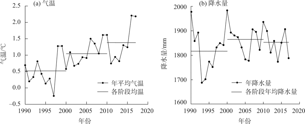
叶如藏布流域冰川和冰湖众多,冰川融水是当地重要的淡水资源,是冰湖扩张的重要补给,冰湖溃决是当地潜在的自然灾害,因此分析该区域冰川和冰湖的现状与变化特征具有重要的现实意义。基于Landsat系列遥感影像,分析1990—2020年叶如藏布流域冰川和冰湖的分布与变化特征。结果表明:(1) 近30 a来叶如藏布流域冰川面积整体呈退缩趋势,由1990年167.80 km2退缩到2020年128.92 km2,共退缩38.88 km2,年均退缩率为0.77%·a-1,且研究区冰川主要分布在海拔5800~6400 m之间,集中分布在5°~20°的坡度上。(2) 与冰川变化趋势相反,研究时段冰湖整体表现为扩张趋势,由1990年5.72 km2增加到2020年8.81 km2,30 a共增加3.09 km2,年均增长率为1.80%·a-1。(3) 冰湖主要分布在海拔5000~5600 m范围内,坡度在0~10°分布面积较多,表碛覆盖型冰川与非表碛覆盖型冰川对冰湖有着不同程度的影响。(4) 1990—2017年叶如藏布流域温度与降水波动较大,温度整体呈上升趋势,降水量则波动下降,导致叶如藏布流域的冰川消融,冰湖扩张。通过上述研究以期为叶如藏布流域地区提供详细的冰川和冰湖面积分布与变化特征基础数据,为防灾减灾提供一定的支撑。
丁悦凯, 刘睿, 张翠兰, 童丽媛, 董军. 喜马拉雅地区叶如藏布流域冰川和冰湖变化遥感监测研究[J]. 干旱区地理, 2022, 45(6): 1870-1880.
DING Yuekai, LIU Rui, ZHANG Cuilan, TONG Liyuan, DONG Jun. Remote sensing monitoring of glacier and glacial lake changes in Yairu Zangbo Basin, Himalayas[J]. Arid Land Geography, 2022, 45(6): 1870-1880.
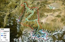
图1
研究区概况"

表1
叶如藏布流域冰川和冰湖解译影像"
| 获取时间(年-月-日) | 传感器 | 行列号 | 分辨率/m | 云量/% |
|---|---|---|---|---|
| 1990-04-11* | TM | 139/41 | 30 | 29.0 |
| 1990-06-14 | TM | 139/41 | 30 | 42.0 |
| 1990-10-20* | TM | 139/41 | 30 | 31.3 |
| 1990-12-23* | TM | 139/41 | 30 | 17.5 |
| 2000-06-17* | ETM+ | 139/41 | 30 | 41.7 |
| 2000-09-13* | TM | 139/41 | 30 | 32.8 |
| 2000-10-15* | TM | 139/41 | 30 | 14.0 |
| 2000-12-06 | ETM+ | 139/41 | 30 | 0.7 |
| 2010-06-13* | ETM+ | 139/41 | 30 | 58.2 |
| 2010-07-15* | ETM+ | 139/41 | 30 | 75.6 |
| 2010-10-03* | ETM+ | 139/41 | 30 | 39.7 |
| 2010-12-06 | ETM+ | 139/41 | 30 | 36.8 |
| 2020-05-31* | OLI | 139/41 | 30 | 78.3 |
| 2020-06-16* | OLI | 139/41 | 30 | 28.1 |
| 2020-10-22 | OLI | 139/41 | 30 | 10.6 |
| 2020-11-23* | OLI | 139/41 | 30 | 9.3 |
表2
叶如藏布流域冰川和冰湖边界缓冲区面积及误差率"
| 类别 | 年份 | 缓冲区面积/km2 | 面积/km2 | 误差率/% |
|---|---|---|---|---|
| 冰川 | 1990 | 174.05 | 167.80 | 3.72 |
| 冰川 | 2000 | 160.54 | 153.89 | 4.32 |
| 冰川 | 2010 | 152.01 | 145.66 | 4.36 |
| 冰川 | 2020 | 135.26 | 128.92 | 4.92 |
| 冰湖 | 1990 | 5.92 | 5.72 | 3.55 |
| 冰湖 | 2000 | 6.98 | 6.68 | 4.49 |
| 冰湖 | 2010 | 6.32 | 6.05 | 4.46 |
| 冰湖 | 2020 | 9.13 | 8.81 | 3.63 |
表3
1990—2020年叶如藏布流域冰川面积分布及变化"
| 年份 | 面积/km2 | 退缩量/km2 | 面积变化率/% | 年均退缩率/%·a-1 |
|---|---|---|---|---|
| 1990 | 167.80 | - | - | - |
| 2000 | 153.89 | 13.91 | 8.29 | 0.83 |
| 2010 | 145.66 | 8.24 | 5.35 | 0.54 |
| 2020 | 128.92 | 16.74 | 11.49 | 1.14 |
| 总计 | - | 38.88 | 23.17 | 0.77 |
图2
30 a叶如藏布流域冰川面积变化"
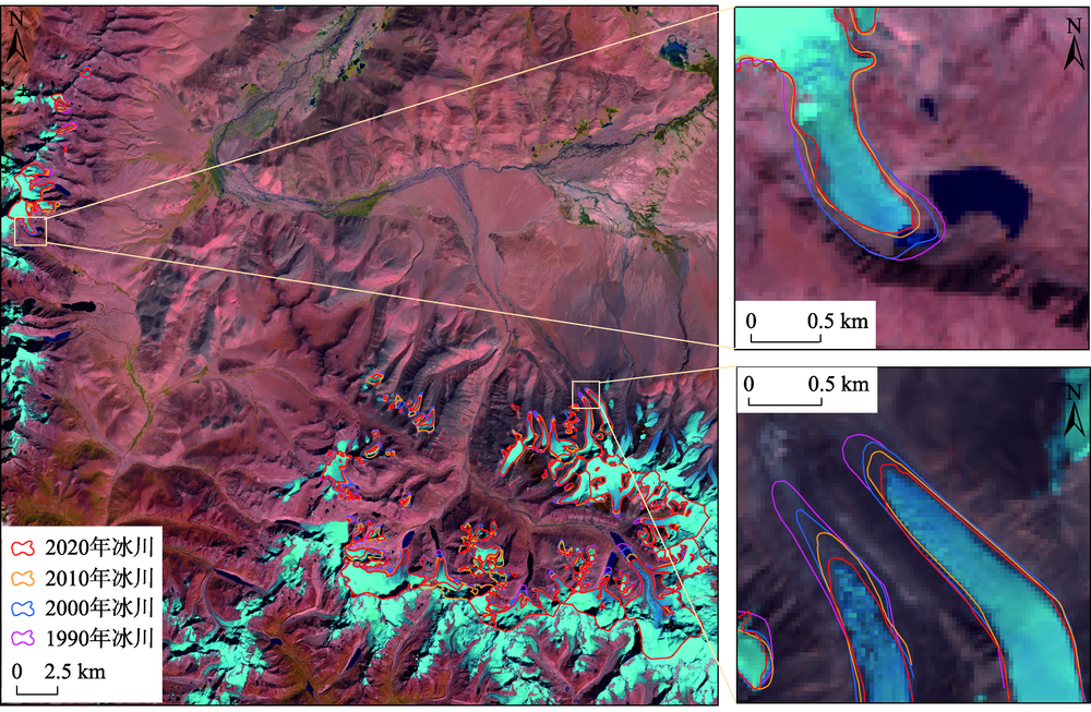

图3
1990—2020年叶如藏布流域不同海拔冰川面积分布及变化"
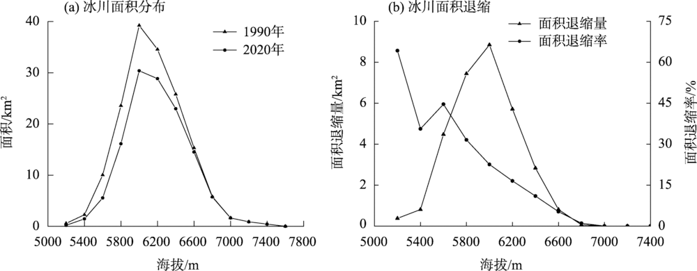
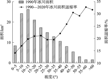
图4
1990—2020年叶如藏布流域不同坡度冰川面积分布及变化"

表4
1990—2020年叶如藏布流域表碛覆盖型与非表碛覆盖型冰川面积变化"
| 年份 | 表碛覆盖型 | 非表碛覆盖型 | |||||
|---|---|---|---|---|---|---|---|
| 面积/km2 | 数目 | 平均规模/km2 | 面积/km2 | 数目 | 平均规模/km2 | ||
| 1990 | 45.19 | 4 | 11.30 | 122.61 | 106 | 1.16 | |
| 2020 | 40.30 | 4 | 10.07 | 88.62 | 126 | 0.70 | |
表5
1990—2020年叶如藏布流域不同规模冰川面积及数目统计"
| 规模/km2 | 1990年 | 2020年 | |||
|---|---|---|---|---|---|
| 数目/条 | 面积/km2 | 数目/条 | 面积/km2 | ||
| ≤0.2 | 37 | 4.18 | 76 | 5.21 | |
| 0.2~0.5 | 32 | 10.83 | 24 | 6.90 | |
| 0.5~1 | 12 | 8.67 | 6 | 4.61 | |
| 1~2 | 10 | 15.41 | 9 | 13.44 | |
| 2~5 | 10 | 31.23 | 8 | 21.43 | |
| 5~10 | 6 | 51.17 | 4 | 33.78 | |
| 10~20 | 2 | 23.32 | 2 | 21.78 | |
| 20~50 | 1 | 23.19 | 1 | 21.77 | |
| 总计 | 110 | 167.80 | 130 | 128.92 | |
表6
1990—2020年叶如藏布流域冰湖面积分布及变化"
| 年份 | 面积/km2 | 变化量/km2 | 面积变化率/% | 年均面积变化率/%·a-1 |
|---|---|---|---|---|
| 1990 | 5.72 | - | - | - |
| 2000 | 6.68 | 0.96 | 16.78 | 1.68 |
| 2010 | 6.05 | 0.63 | 9.43 | -0.94 |
| 2020 | 8.81 | 2.76 | 45.62 | 4.56 |
| 总计 | - | 3.09 | 54.02 | 1.80 |
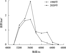
图5
1990—2020年叶如藏布流域不同海拔冰湖面积分布"

表7
1990—2020年叶如藏布流域不同海拔冰湖面积变化率"
| 海拔/m | 年均面积变化率/%·a-1 | ||
|---|---|---|---|
| 1990—2000年 | 2000—2010年 | 2010—2020年 | |
| 4800~5000 | 4.76 | 0.00 | 98.20 |
| 5000~5200 | -11.87 | -7.89 | -33.65 |
| 5200~5400 | -5.12 | 0.68 | -78.11 |
| 5400~5600 | -35.21 | -8.41 | -194.57 |
| 5600~5800 | -18.34 | 58.98 | 11.26 |
| 5800~6000 | -9.39 | 83.83 | 21.52 |
| 6000~6200 | 22.66 | 97.98 | 15.40 |
| 6200~6400 | 66.67 | 100.00 | - |
| 6400~6600 | - | - | - |
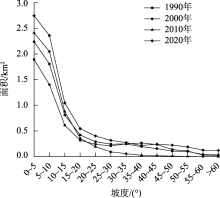
图6
1990—2020年叶如藏布流域不同坡度冰湖面积分布"
表8
1990—2020年叶如藏布流域不同类型的冰湖面积分布及变化"
| 年份 | 受表碛覆盖型冰川影响的冰湖 | 受非表碛覆盖型冰川影响的冰湖 | |||||
|---|---|---|---|---|---|---|---|
| 面积/km2 | 数目 | 平均规模/km2 | 面积/km2 | 数目 | 平均规模/km2 | ||
| 1990 | 2.96 | 5 | 0.59 | 2.76 | 18 | 0.15 | |
| 2020 | 3.99 | 5 | 0.79 | 4.82 | 34 | 0.14 | |

图7
1990—2017年叶如藏布流域气温和降水量变化"
| [1] | 秦大河, 效存德, 丁永建, 等. 国际冰冻圈研究动态和我国冰冻圈研究的现状与展望[J]. 应用气象学报, 2006, 17(6): 649-656. |
| [Qin Dahe, Xiao Cunde, Ding Yongjian, et al. Progress on cryospheric studies by international and Chinese communities and perspectives[J]. Journal of Applied Meteorology, 2006, 17(6): 649-656.] | |
| [2] | 沈永平, 王国亚. IPCC第一工作组第五次评估报告对全球气候变化认知的最新科学要点[J]. 冰川冻土, 2013, 35(5): 1068-1076. |
| [Shen Yongping, Wang Guoya. Key findings and assessment results of IPCC WGI Fifth Assessment Report[J]. Journal of Glaciology and Gcocryology, 2013, 35(5): 1068-1076.] | |
| [3] | 钟歆羽, 康世昌, 郭万钦, 等. 最近十多年来冰冻圈加速萎缩[J]. 冰川冻土, 2021, 43(6): 1-8. |
| [Zhong Xinyu, Kang Shichang, Guo Wanqin, et al. The rapidly shrinking cryopshere in the past decade: An interpretation of cryospheric changes from IPCC WGI Sixth Assessment Report[J]. Journal of Glaciology and Geocryology, 2021, 43(6): 1-8.] | |
| [4] | 康尔泗. 中国西北干旱区冰雪水资源和出山径流[M]. 北京: 科学出版社, 2002. |
| [Kang Ersi. Snow and ice water resources and mountain runoff in arid areas of northwest China[M]. Beijing: Science Press, 2002.] | |
| [5] | 刘潮海, 康尔泗, 刘时银, 等. 西北干旱区冰川变化及其径流效应研究[J]. 中国科学: 地球科学, 1999(增刊1): 55-62. |
| [Liu Chaohai, Kang Ersi, Liu Shiyin, et al. Study on glacier change and its runoff effect in arid area of northwest China[J]. Science China Earth Sciences, 1999(Suppl. 1): 55-62.] | |
| [6] |
上官冬辉, 刘时银, 丁永建, 等. 玉龙喀什河源区32年来冰川变化遥感监测[J]. 地理学报, 2004, 59(6): 855-862.
doi: 10.11821/xb200406007 |
|
[Shangguan Donghui, Liu Shiyin, Ding Yongjian, et al. Glacier changes at the head of Yurungkax River in the west Kunlun Mountains in the past 32 years[J]. Acta Geographica Sinica, 2004, 59(6): 855-862.]
doi: 10.11821/xb200406007 |
|
| [7] | 叶庆华, 陈锋, 姚檀栋, 等. 近30年来喜马拉雅山脉西段纳木那尼峰地区冰川变化的遥感监测研究[J]. 遥感学报, 2007, 11(4): 511-520. |
| [Ye Qinghua, Cheng Feng, Yao Tandong, et al. Tupu of glacier variations in the Mt. Naimona’ Nyi region, western Himalays, in the last three decades[J]. Journal of Remote Sensing, 2007, 11(4): 511-520.] | |
| [8] |
张强弓. 喜马拉雅冰川消融影响区域生态环境[J]. 自然杂志, 2020, 42(5): 401-406.
doi: 10.3969/j.issn.0253-9608.2020.05.007 |
|
[Zhang Qianggong. Melting Himalayan glaciers impact the regional eco-environment[J]. Chinese Journal of Nature, 2020, 42(5): 401-406.]
doi: 10.3969/j.issn.0253-9608.2020.05.007 |
|
| [9] |
Richter K, Marzeion B, Riva R. The effect of spatial averaging and glacier melt on detecting a forced signal in regional sea level[J]. Environmental Research Letters, 2017, 12(3): 034004, doi: 10.1088/1748-9326/aa5967.
doi: 10.1088/1748-9326/aa5967 |
| [10] | 宫鹏, 姚晓军, 孙美平, 等. 1967—2014年科西河流域冰湖时空变化[J]. 生态学报, 2017, 37(24): 8422-8432. |
| [Gong Peng, Yao Xiaojun, Sun Meiping, et al. Spatial-temporal variations of glacial lakes in the Koshi River Basin from 1967 to 2014[J]. Acta Ecologica Sinica, 2017, 37(24): 8422-8432.] | |
| [11] |
Banerjee P, Ghose M K, Pradhan R. Identification of essential descriptors in spatial socioeconomic impact assessment modeling: A case study of highway broadening in Sikkim Himalaya[J]. Journal of Geovisualization and Spatial Analysis, 2019, 3(1): 4, doi: 10.1007/s41651-019-0027-0.
doi: 10.1007/s41651-019-0027-0 |
| [12] |
Brahmbhatt R M, Bahuguna I M, Rathore B P, et al. Significance of glacio-morphological factors in glacier retreat: A case study of part of Chenab Basin, Himalaya[J]. Journal of Mountain Science, 2017, 14(1): 128-141.
doi: 10.1007/s11629-015-3548-0 |
| [13] |
Du W J, Liu X, Guo J Y, et al. Analysis of the melting glaciers in southeast Tibet by ALOS-PALSAR data[J]. Terrestrial, Atmospheric and Oceanic Sciences, 2019, 30(1): 7-19.
doi: 10.3319/TAO.2018.07.09.03 |
| [14] |
冀琴, 董军, 刘睿, 等. 1990—2015年喜马拉雅山冰川变化的遥感监测及动因分析[J]. 地理科学, 2020, 40(3): 486-496.
doi: 10.13249/j.cnki.sgs.2020.03.017 |
|
[Ji Qin, Dong Jun, Liu Rui, et al. Glacier changes in response to climate change in the Himalayas in 1990—2015[J]. Scientia Geographica Sinica, 2020, 40(3): 486-496.]
doi: 10.13249/j.cnki.sgs.2020.03.017 |
|
| [15] | 蒋亮虹. 基于多源遥感数据的喜马拉雅中段冰川变化监测与分析[D]. 湘潭: 湖南科技大学, 2015. |
| [Jiang Lianghong. Monitoring and analysis of glacier change in the middle Himalaya based on multi-source remote sensing data[D]. Xiangtan: Hunan University of Science and Technology, 2015.] | |
| [16] | 李海, 杨成生, 惠文华, 等. 基于遥感技术的高山极高山区冰川冰湖变化动态监测——以西藏藏南希夏邦玛峰地区为例[J]. 中国地质灾害与防治学报, 2021, 32(5): 10-17. |
| [Li Hai, Yang Chengsheng, Hui Wenhua, et al. Changes of glaciers and glacier lakes in alpine and extremelyalpine regions using remote sensing technology: A case study in the Shisha Pangma area of southern Tibet[J]. Chinese Journal of Geological Hazards and Prevention, 2021, 32(5): 10-17.] | |
| [17] | 徐道明, 冯清华. 西藏喜马拉雅山区危险冰湖及其溃决特征[J]. 地理学报, 1989, 56(3): 343-351. |
| [Xu Daoming, Feng Qinghua. Dangerous glacial lakes and their outburst features in the Himalayas of Tibet[J]. Journal of Geography, 1989, 56(3): 343-351.] | |
| [18] | 张波, 张瑞, 刘国祥, 等. 基于SAR影像的贡巴冰川末端冰湖年际变化监测及溃决规律分析[J]. 武汉大学学报, 2019, 44(7): 1054-1064. |
| [Zhang Bo, Zhang Rui, Liu Guoxiang, et al. Monitoring of interannual variabilities and outburst regularities analysis of glacial lakes at the end of Gongba glacier utilizing SAR images[J]. Geomatics and Information Science of Wuhan University, 2019, 44(7): 1054-1064.] | |
| [19] | 安国英, 韩磊, 涂杰楠, 等. 中国喜马拉雅山地区冰川1999—2015年期间动态变化遥感调查[J]. 现代地质, 2019, 33(5): 1086-1097. |
| [An Guoying, Han Lei, Tu Jienan, et al. Remote sensing survey on glacial dynamic evolution in the Himalayas in China during 1999—2015[J]. Geoscience, 2019, 33(5): 1086-1097.] | |
| [20] | Romshoo S A, Abdullah T, Bhat M H. Evaluation of the global glacier inventories and assessment of glacier elevation changes over north-western Himalaya[R]. Germany: Earth System Science Data, 2021. |
| [21] | 王仕哲, 柯长青. 基于ALOS PALSAR的喜马拉雅山冰川流速分布及变化[J]. 遥感技术与应用, 2018, 33(5): 942-955. |
| [Wang Shizhe, Ke Changqing. Distribution and variation of glacier velocity in Himalayas based on ALOS PALSAR[J]. Remote Sensing Technology and Application, 2018, 33(5): 942-955.] | |
| [22] | 冀琴. 1990—2015年喜马拉雅山冰川变化及其对气候波动的响应[D]. 兰州: 兰州大学, 2018. |
| [Ji Qin. Himalayan glacier change and its response to climate fluctuations from 1990 to 2015[D]. Lanzhou: Lanzhou University, 2018.] | |
| [23] | 安丽娜. 叶如藏布流域夏季地表水化学与氢氧同位素特征研究[D]. 兰州: 西北师范大学, 2017. |
| [An Li’na. Study on the characteristics of surface water chemistry and hydrogen and oxygen isotopes in Yairu Zangbo Basin in summer[D]. Lanzhou: Northwest Normal University, 2017.] | |
| [24] |
刘时银, 姚晓军, 郭万钦, 等. 基于第二次冰川编目的中国冰川现状[J]. 地理学报, 2015, 70(1): 3-16.
doi: 10.11821/dlxb201501001 |
|
[Liu Shiyin, Yao Xiaojun, Guo Wanqin, et al. The contemporary glaciers in China based on the Second Chinese Glacier Inventory[J]. Acta Geographica Sinica, 2015, 70(1): 3-16.]
doi: 10.11821/dlxb201501001 |
|
| [25] |
冀琴, 刘睿, 杨太保. 1990—2015年喜马拉雅山冰川变化的遥感监测[J]. 地理研究, 2020, 39(10): 2403-2414.
doi: 10.11821/dlyj020190283 |
|
[Ji Qin, Liu Rui, Yang Taibao. Glacier variations in the Himalayas during 1990—2015[J]. Geographical Research, 2020, 39(10): 2403-2414.]
doi: 10.11821/dlyj020190283 |
|
| [26] | 汤远航, 李梦琦, 邓铃, 等. 1990—2020年朋曲流域冰川变化及其对气候变化的响应[J]. 干旱区地理, 2022, 45(1): 27-36. |
| [Tang Yuanhang, Li Mengqi, Deng Ling, et al. Glacier change and its response to climate change in Pumqu Basin in 1990—2020[J]. Arid Land Geography, 2022, 45(1): 27-36.] | |
| [27] | 钟鼎杰, 杨存建. 基于遥感影像的山岳冰川信息计算机解译方法探讨——以梅里雪山为例[J]. 云南大学学报(自然科学版), 2021, 43(5): 942-952. |
| [Zhong Dingjie, Yang Cunjian. Discussion on computer interpretation method of mountain glacier information based on remote sensing: A case study in Meili Snow Mountain[J]. Journal of Yunnan University (Natural Sciences Edition), 2021, 43(5): 942-952.] | |
| [28] |
Zhang Qibing, Kang Shichang. Glacier elevation change in the western Qilian Mountains as observed by TerraSAR-X/TanDEM-X images[J]. Geocarto International, 2021, 36(12): 1365-1377.
doi: 10.1080/10106049.2019.1648563 |
| [29] |
廖海军, 刘巧, 钟妍, 等. 1990—2019年贡嘎山地区典型冰川表碛覆盖变化及其空间差异[J]. 地理学报, 2021, 76(11): 2647-2659.
doi: 10.11821/dlxb202111004 |
|
[Liao Haijun, Liu Qiao, Zhong Yan, et al. Supraglacial debris-cover change and its spatial heterogeneity in the Mount Gongga, 1990—2019[J]. Acta Geographica Sinica, 2021, 76(11): 2647-2659.]
doi: 10.11821/dlxb202111004 |
|
| [30] | 阿布都拉·阿不都卡地尔, 董玉森, 务宇宽, 等. 1972—2017年南阿尔泰山中部冰湖变化特征及其对气候变化的响应[J]. 地质科技通报, 2020, 39(4): 94-102. |
| [Abudukadier Abudula, Dong Yusen, Wu Yukuan, et al. Characteristics of glacial lakes in the central part of the southern Altai Mountains from 1972 to 2017 and their responses to climate changes[J]. Bulletin of Geological Science and Technology, 2020, 39(4): 94-102.] | |
| [31] |
吴坤鹏, 刘时银, 郭万钦. 1980—2015年南迦巴瓦峰地区冰川变化及其对气候变化的响应[J]. 冰川冻土, 2020, 42(4): 1115-1125.
doi: 10.7522/j.issn.1000-0240.2020.0098 |
|
[Wu Kunpeng, Liu Shiyin, Guo Wanqin. Glacier variation and its response to climate change in the Mount Namjagbarwa from 1980 to 2015[J]. Journal of Glaciology and Geocryology, 2020, 42(4): 1115-1125.]
doi: 10.7522/j.issn.1000-0240.2020.0098 |
| [1] | 王南, 刘泽轩, 郑江华, 仲涛, 孟乘枫. 天山冰湖分布时空特征及驱动力分析[J]. 干旱区地理, 2024, 47(9): 1472-1481. |
| [2] | 牟建新, 李忠勤, 王璞玉, 梁鹏斌, 王炎强, 白昌彬, 王芳龙. 萨吾尔山冰川现状及演化过程[J]. 干旱区地理, 2024, 47(8): 1277-1291. |
| [3] | 车彦军, 张明军, 陈亚宁, 朱成刚, 刘玉婷. 近30 a东昆仑阿牙克库木湖水量变化及其补给关系研究[J]. 干旱区地理, 2024, 47(7): 1116-1126. |
| [4] | 贾尚坤, 魏俊锋, 张法刚, 王欣. 喜马拉雅山入湖冰川物质变化研究综述[J]. 干旱区地理, 2024, 47(7): 1156-1164. |
| [5] | 谢俊博, 王兴鹏, 何帅, 刘洋, 忠智博, 李妍, 洪国军. 基于光谱指数建模的沙井子灌区土壤盐分反演[J]. 干旱区地理, 2024, 47(7): 1199-1209. |
| [6] | 王小丽, 周凌翔, 王秀东, 何颖. 1990—2020年波曲流域冰川冰湖时空变化及其对气候变化的响应[J]. 干旱区地理, 2024, 47(5): 810-819. |
| [7] | 陈满, 陈亚宁, 方功焕, 李玉朋, 孙慧兰. 昆仑山北坡冰川湖变化及其溃决风险评估[J]. 干旱区地理, 2024, 47(10): 1628-1639. |
| [8] | 陈丽花, 车彦军, 曹昀, 张明军, 谷来磊, 吴佳康, 吕卫卫. 东昆仑鲸鱼湖流域冰川、湖泊对气候变化的响应[J]. 干旱区地理, 2024, 47(10): 1640-1650. |
| [9] | 田昊玮, 陈伏龙, 龙爱华, 刘静, 海洋. 博尔塔拉河源流区径流对气候变化的响应及预测[J]. 干旱区地理, 2023, 46(9): 1432-1442. |
| [10] | 杨雪雯, 王宁练, 梁倩, 陈安安. 近60 a天山北坡冰川变化研究[J]. 干旱区地理, 2023, 46(7): 1073-1083. |
| [11] | 冀琴, 张翠兰, 丁悦凯, 曹香芹, 梁文莉. 基于多源遥感数据的珠峰自然保护区冰川监测研究[J]. 干旱区地理, 2023, 46(10): 1591-1601. |
| [12] | 王振峰,蒋宗立,刘时银,杨婧睿,马致远,王雯清. 中喀喇昆仑布拉尔杜冰川近期跃动分析[J]. 干旱区地理, 2022, 45(4): 1032-1041. |
| [13] | 汤远航,李梦琦,邓铃,王小丽. 1990—2020年朋曲流域冰川变化及其对气候变化的响应[J]. 干旱区地理, 2022, 45(1): 27-36. |
| [14] | 李海娟,刘时银,吴坤鹏. 喀喇昆仑山乔戈里峰北坡主要冰川运动特征[J]. 干旱区地理, 2021, 44(5): 1350-1364. |
| [15] | 任才,龙爱华,於嘉闻,尹振良,张继. 气候与下垫面变化对叶尔羌河源流径流的影响[J]. 干旱区地理, 2021, 44(5): 1373-1383. |
| Viewed | ||||||||||||||||||||||||||||||||||||||||||||||||||
|
Full text 141
|
|
|||||||||||||||||||||||||||||||||||||||||||||||||
|
Abstract 428
|
|
|||||||||||||||||||||||||||||||||||||||||||||||||
Cited |
|
|||||||||||||||||||||||||||||||||||||||||||||||||
| Shared | ||||||||||||||||||||||||||||||||||||||||||||||||||
|
||