干旱区地理 ›› 2026, Vol. 49 ›› Issue (5): 1039-1051.doi: 10.12118/j.issn.1000-6060.2025.361 cstr: 32274.14.ALG2025361
刘潇1,2( ), 张新焕1(), 陈洋1,2, 闫海龙3
收稿日期:2025-06-23
修回日期:2025-08-25
出版日期:2026-05-25
发布日期:2026-05-25
通讯作者:
张新焕(1978-),女,博士,研究员,主要从事区域可持续发展等方面的研究. E-mail: zhangxh@ms.xjb.ac.cn作者简介:刘潇(2001-),女,硕士研究生,主要从事城镇化与城乡融合等方面的研究. E-mail: liuxiao231@mails.ucas.ac.cn
基金资助:
LIU Xiao1,2(), ZHANG Xinhuan1(), CHEN Yang1,2, YAN Hailong3
Received:2025-06-23
Revised:2025-08-25
Published:2026-05-25
Online:2026-05-25
摘要:
城乡空间关系是推进城乡融合进程的基础,也影响城乡间的要素流动效果,研究新疆城乡融合的空间条件,对于明确要素流动的空间需求,打破城乡二元结构具有重要意义。围绕城乡融合的“空间联系-城乡动力-空间条件”这一逻辑思路,基于2022年数据,综合运用空间可达性、熵值法等方法测度新疆城乡融合的空间联系、融合动力和空间条件,并结合绿洲小区关键特征分析城乡融合空间条件分化方向。结果表明:(1) 高可达性区域相互叠加处,乡镇空间联系整体较强,要素流动呈网状扩散;城镇带动力强的县(市)城镇化水平和工业化水平较高,乡村支撑力强的县(市)农业规模化水平较高。(2) 在城乡融合空间条件形成过程中,城乡空间联系是基础,城乡融合动力起决定性作用。空间条件好的乡镇主要分布在天山北坡、伊犁河谷、吐哈盆地以及南疆和沿边部分区域。(3) 绿洲城乡融合空间条件分化方向可分为小绿洲-弱中心、小绿洲-单中心、中绿洲-强中心、双绿洲-强中心和大绿洲-多中心5种类型。
刘潇, 张新焕, 陈洋, 闫海龙. “乡镇-县域-绿洲”视角下新疆城乡融合的空间条件测度研究[J]. 干旱区地理, 2026, 49(5): 1039-1051.
LIU Xiao, ZHANG Xinhuan, CHEN Yang, YAN Hailong. Measurement of spatial conditions for urban-rural integration in Xinjiang from the perspective of “township-county-oasis”[J]. Arid Land Geography, 2026, 49(5): 1039-1051.
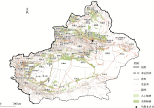
图1
研究区概况 注:基于新疆维吾尔自治区自然资源厅标准地图服务网站审图号为新S(2023)061号的标准地图制作,底图边界无修改。下同。"

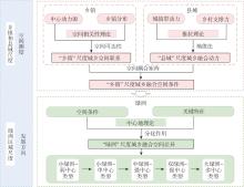
图2
研究框架"
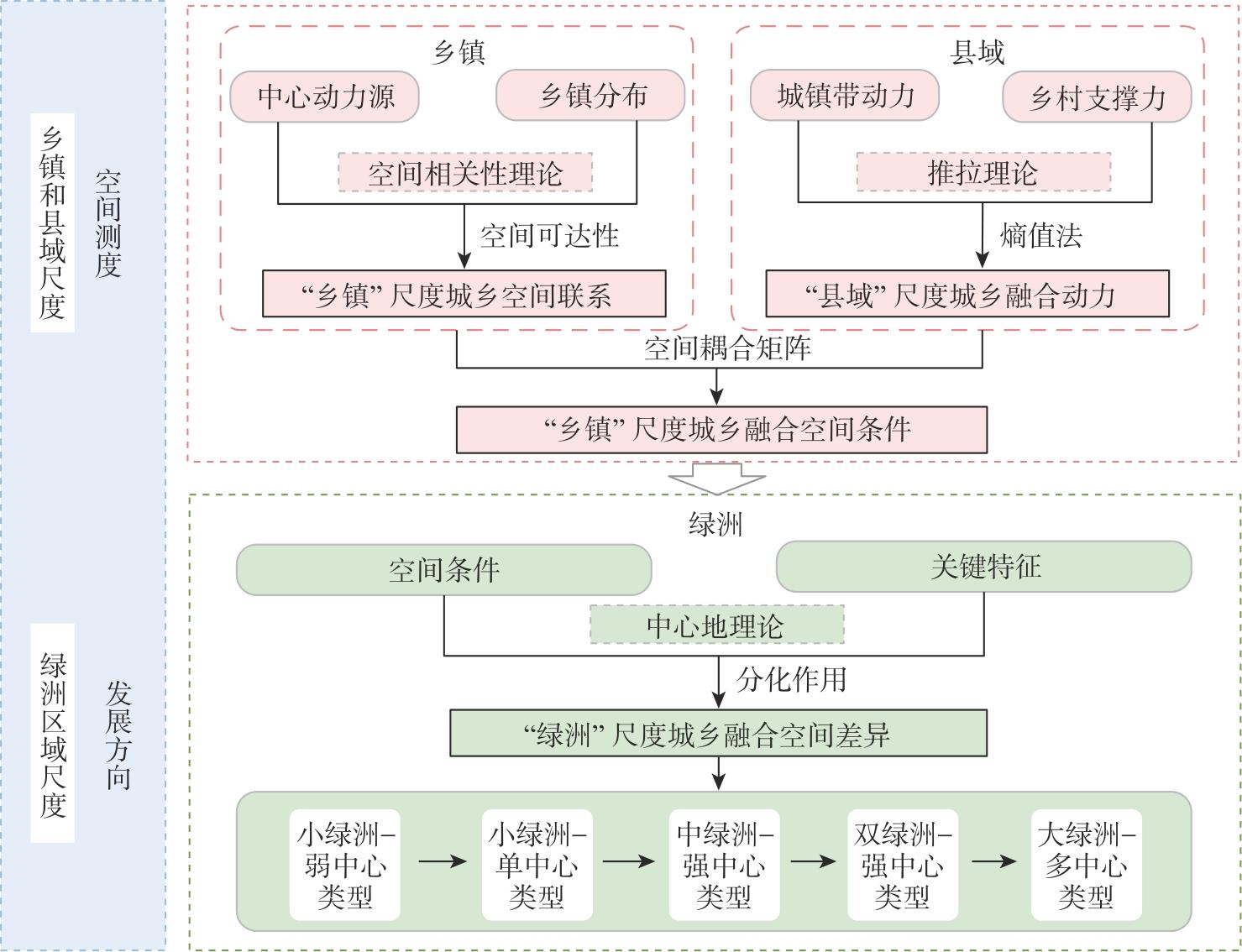
表1
各类型道路速度值"
| 道路类型 | 高速公路 | 国道 | 省道 | 县道 | 空白地区 |
|---|---|---|---|---|---|
| 赋值速度/km·h-1 | 120 | 80 | 60 | 40 | 5 |
表2
发展中心可达性区域分级"
| 发展中心类型 | 发展中心可达性 | 强联系区/h | 中联系区/h | 弱联系区/h |
|---|---|---|---|---|
| 城区 | 至首府城市时间 | <1 | 1~3 | >3 |
| 至区域中心城市时间 | <1 | 1~3 | >3 | |
| 至县城城区时间 | <1 | 1~3 | >3 | |
| 园区 | 至产业园区时间 | <1 | 1~3 | >3 |
| 景区 | 至5A级旅游景区时间 | <1 | 1~3 | >3 |
| 至4A级旅游景区时间 | <1 | 1~3 | >3 |
表3
城镇带动力、乡村支撑力评价指标体系"
| 一级指标 | 二级指标 | 计算方法 | 时间截面(年份) | 属性 |
|---|---|---|---|---|
| 城镇带动力 | 常住人口城镇化水平 | 常住城镇人口/常住总人口 | 2022 | 正向 |
| 人均GDP | 地区生产总值/常住总人口 | 2022 | 正向 | |
| 建成区面积 | 直接获得 | 2022 | 正向 | |
| 二三产业占比 | 二三产业增加值/地区生产总值 | 2022 | 正向 | |
| 医疗卫生机构床位 | 直接获得 | 2022 | 正向 | |
| 数字经济规模 | 直接获得 | 2022 | 正向 | |
| 建成区绿化覆盖率 | 直接获得 | 2022 | 正向 | |
| 乡村支撑力 | 人均耕地 | 耕地面积/乡村人口 | 2020 | 正向 |
| 人均农业总产值 | 农业产值/乡村人口 | 2022 | 正向 | |
| 亩均机械总动力 | 农业机械总动力/农作物总播种面积 | 2022 | 正向 | |
| 农业服务水平 | 农林牧渔专业及辅助性活动产值/ 农林牧渔业总产值 | 2022 | 正向 | |
| 农业加工企业 | 农产品加工企业个数 | 2022 | 正向 | |
| 休闲旅游业发展 | 民宿个数与农家乐个数之和 | 2022 | 正向 | |
| 生态发展水平 | 各县(市)NDVI平均值 | 2022 | 正向 |
表4
城乡融合动力耦合分级规则"
| 乡村支撑力 | 城镇带动力 | ||
|---|---|---|---|
| 强 | 中 | 弱 | |
| 强 | 高 | 中 | 低 |
| 中 | 高 | 中 | 低 |
| 弱 | 中 | 低 | 低 |
表5
城乡融合空间条件耦合分级规则"
| 城乡联系程度 | 城乡融合动力 | ||
|---|---|---|---|
| 强 | 中 | 弱 | |
| 强 | 较好 | 较好 | 一般 |
| 中 | 较好 | 一般 | 较弱 |
| 弱 | 一般 | 较弱 | 较弱 |
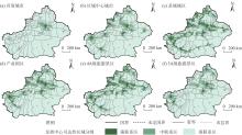
图3
发展中心可达性区域分级结果"
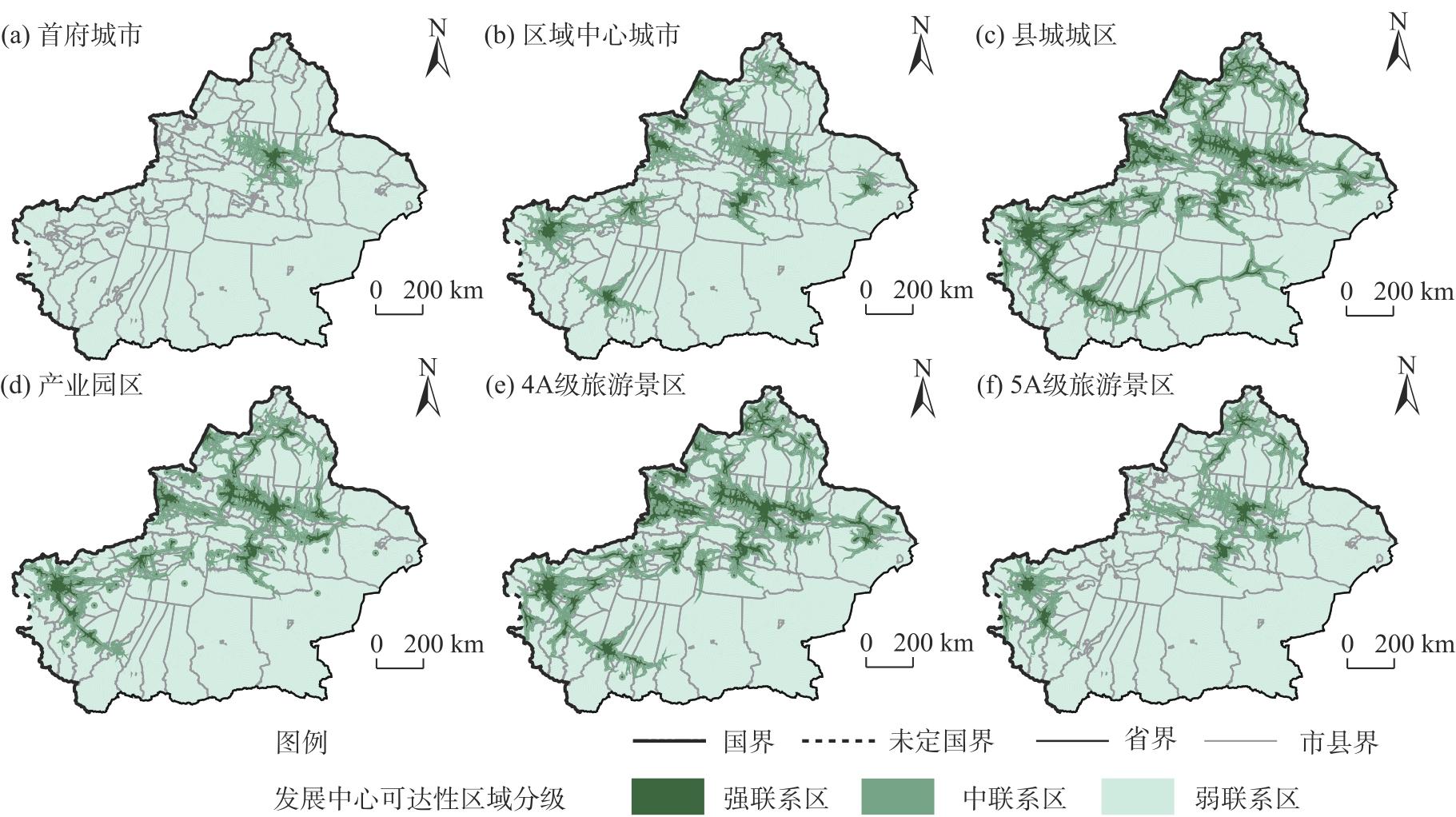

图4
城乡空间联系分级结果"
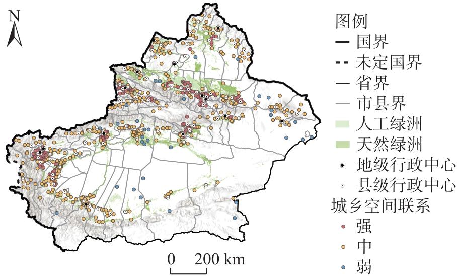
图5
城乡动力关系分级结果"
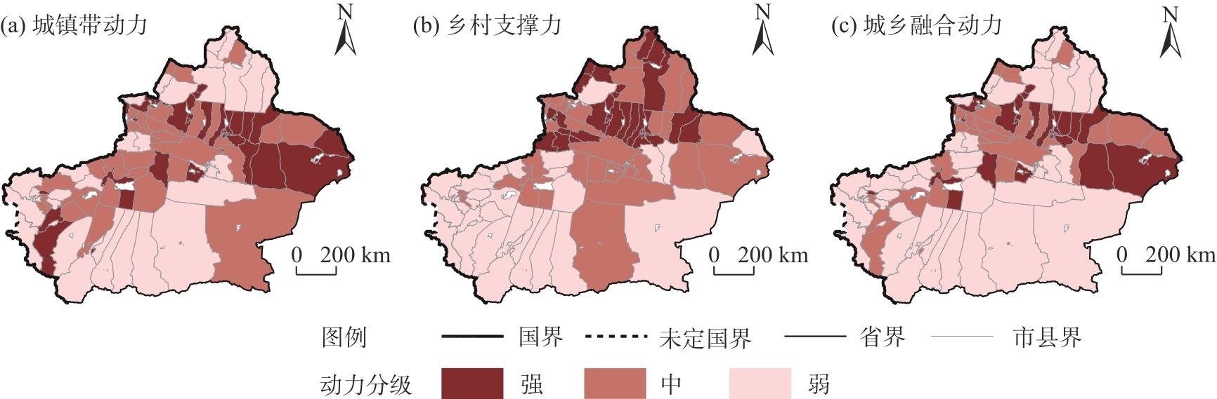
图6
城乡融合空间条件分级结果"
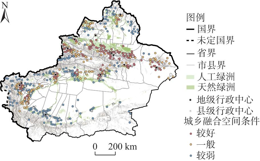
表6
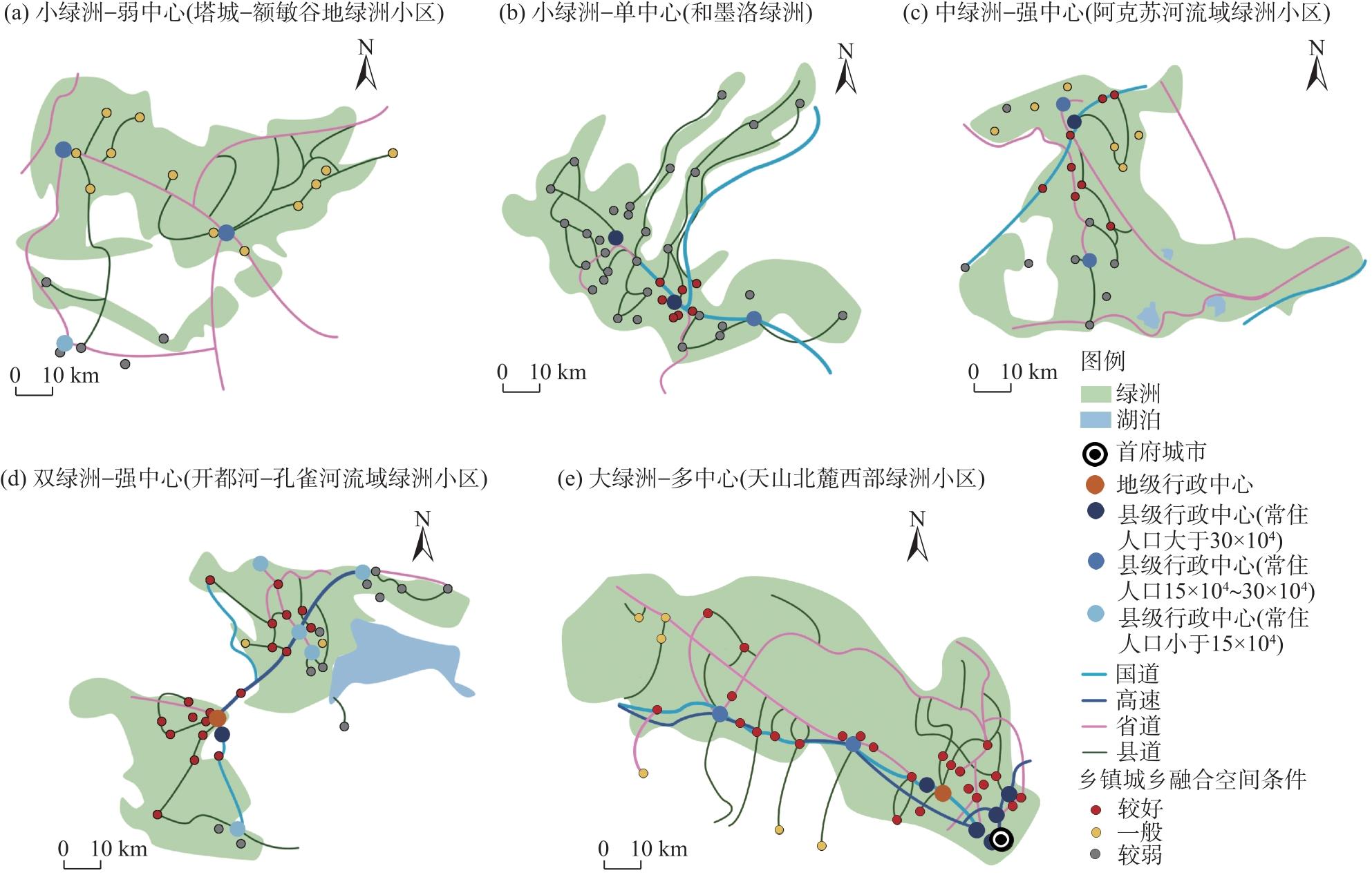
不同类型绿洲关键特征对比"
| 绿洲类型 | 绿洲小区 | 绿洲面积 /km2 | 绿洲人口规模 /104人 | 绿洲带动中心 | |||
|---|---|---|---|---|---|---|---|
| 县(市) | 建成区 面积/km2 | 二三产业 增加值/108元 | 人口变化 幅度/% | ||||
| 小绿洲-弱中心 | 额尔齐斯-乌伦古河两河绿洲小区 | 5854 | 65 | 阿勒泰市 | 18.00 | 97.16 | -3.02 |
| 塔城-额敏谷地绿洲小区 | 5128 | 58 | 塔城市 | 17.70 | 89.60 | -6.07 | |
| 和田河流域绿洲小区 (除和墨洛绿洲外) | 1284 | 74 | 皮山县 | 6.00 | 37.23 | 0.18 | |
| 阿尔金山北麓绿洲小区 | 334 | 12 | 且末县 | 4.56 | 25.40 | 0.87 | |
| 小绿洲-单中心 | 艾比湖流域绿洲区 | 2471 | 43 | 博乐市 | 30.00 | 167.60 | 0.32 |
| 吐鲁番绿洲小区 | 1363 | 69 | 高昌区 | 24.23 | 110.52 | -0.32 | |
| 哈密绿洲小区 | 831 | 62 | 伊州区 | 52.25 | 500.24 | -10.36 | |
| 和墨洛绿洲 | 1710 | 171 | 和田市 | 39.14 | 130.83 | 0.20 | |
| 中绿洲-强中心 | 渭干河流域绿洲小区 | 5702 | 124 | 库车市 | 32.40 | 341.94 | 0.09 |
| 阿克苏河流域绿洲小区 | 6206 | 153 | 阿克苏市 | 153.59 | 284.84 | 0.88 | |
| 喀什噶尔河三角洲绿洲小区 | 5911 | 289 | 喀什市 | 98.50 | 264.19 | 0.29 | |
| 叶尔羌河流域绿洲小区 | 6454 | 220 | 莎车县 | 39.03 | 101.09 | 0.16 | |
| 双绿洲-强中心 | 开都河-孔雀河流域绿洲小区 | 5662 | 138 | 库尔勒市 | 98.90 | 931.69 | 0.91 |
| 伊犁谷地绿洲小区 | 4565 | 255 | 伊宁市 | 43.51 | 338.26 | 0.08 | |
| 大绿洲-多中心 | 天山北麓西部绿洲小区 | 15369 | 637 | 乌鲁木齐市 | 545.10 | 3862.24 | 0.69 |
| 克拉玛依市 | 79.42 | 1169.67 | -0.67 | ||||
| 昌吉市 | 69.15 | 483.78 | -3.33 | ||||
| 天山北麓东部绿洲小区 | 3935 | 64 | 阜康市 | 22.62 | 319.58 | 0.00 | |
| 吉木萨尔县 | 13.50 | 507.43 | 12.47 | ||||
| 奇台县 | 17.57 | 216.99 | 0.00 | ||||

图7
新疆5类绿洲的城乡空间关系示意图"
| [1] | 张海鹏. 中国城乡关系演变70年: 从分割到融合[J]. 中国农村经济, 2019(3): 2-18. |
| [Zhang Haipeng. The evolution of China’s urban-rural relations in the past seven decades: From separation to integration[J]. Chinese Rural Economy, 2019(3): 2-18.] | |
| [2] | 张露, 罗必良. 中国工农城乡关系: 历史演进、基本经验与调整策略[J]. 中国农村经济, 2023(6): 2-21. |
| [Zhang Lu, Luo Biliang. The industry-agriculture and urban-rural relations in China: Historical evolution, basic experience and adjustment strategies[J]. Chinese Rural Economy, 2023(6): 2-21.] | |
| [3] |
郭庆宾, 马梦瑶, 程叶青. 海南自由贸易港城乡融合发展水平的时空特征及其驱动机理[J]. 经济地理, 2024, 44(12): 62-71.
doi: 10.15957/j.cnki.jjdl.2024.12.007 |
|
[Guo Qingbin, Ma Mengyao, Cheng Yeqing. Spatio-temporal characteristic of urban-rural integration development level in Hainan free trade port and its driving mechanism[J]. Economic Geography, 2024, 44(12): 62-71.]
doi: 10.15957/j.cnki.jjdl.2024.12.007 |
|
| [4] |
张凌媛, 孙九霞. 乡村主体性及其对乡村地域系统的影响——以广西阳朔县为例[J]. 地理学报, 2025, 80(2): 453-474.
doi: 10.11821/dlxb202502012 |
|
[Zhang Lingyuan, Sun Jiuxia. Rural subjectivity and its impact on rural regional system in Yangshuo County, Guangxi[J]. Acta Geographica Sinica, 2025, 80(2): 453-474.]
doi: 10.11821/dlxb202502012 |
|
| [5] |
朱小会, 于法稳. 县域城乡融合发展的演变特征、区域差异及影响因素研究——以武陵山区64个县为例[J]. 自然资源学报, 2025, 40(5): 1386-1411.
doi: 10.31497/zrzyxb.20250515 |
|
[Zhu Xiaohui, Yu Fawen. Evolution characteristics, regional differences and influencing factors of urban-rural integrated development at the county scale: Take 64 counties in Wuling Mountain area as examples[J]. Journal of Natural Resources, 2025, 40(5): 1386-1411.]
doi: 10.31497/zrzyxb.20250515 |
|
| [6] | 姜长云. 关于农业强国建设的若干认识[J]. 中国农村经济, 2024(4): 20-31. |
| [Jiang Changyun. Some understandings of building up China’s strength in agriculture[J]. Chinese Rural Economy, 2024(4): 20-31.] | |
| [7] | 克劳德·昂利·圣西门. 圣西门选集[M]. 北京: 商务印书馆, 1985: 85-92. |
| [Rouvroy Claude Henri. Selected works of Saint-Simon[M]. Beijing: The Commercial Press, 1985: 85-92.] | |
| [8] | 弗里德里希·恩格斯, 卡尔·马克思. 马克思恩格斯选集: 第一卷[M]. 北京: 人民出版社, 2012: 237. |
| [Engels Friedrich, Marx Karl Heinrich. Selected works of Marx and Engels: Volume I[M]. Beijing: People’s Publishing House, 2012: 237.] | |
| [9] | 费景汉, 古斯塔夫·拉尼斯. 增长和发展: 演进观点[M]. 北京: 商务印书馆, 2004: 204-207. |
| [Fei Jinghan, Ranis Gustav. Growth and development: An evolutionary perspective[M]. Beijing: The Commercial Press, 2004: 204-207.] | |
| [10] | Friedmann J. Regional development policy: A case study of Venezuela[M]. MA: MIT Press, 1966: 45-48. |
| [11] |
刘春芳, 张志英. 从城乡一体化到城乡融合: 新型城乡关系的思考[J]. 地理科学, 2018, 38(10): 1624-1633.
doi: 10.13249/j.cnki.sgs.2018.10.006 |
|
[Liu Chunfang, Zhang Zhiying. From town-country integration to urban-rural integration: New thinking on the relationship between urban and rural areas[J]. Scientia Geographica Sinica, 2018, 38(10): 1624-1633.]
doi: 10.13249/j.cnki.sgs.2018.10.006 |
|
| [12] |
方创琳. 城乡融合发展机理与演进规律的理论解析[J]. 地理学报, 2022, 77(4): 759-776.
doi: 10.11821/dlxb202204001 |
|
[Fang Chuanglin. Theoretical analysis on the mechanism and evolution law of urban-rural integration development[J]. Acta Geographica Sinica, 2022, 77(4): 759-776.]
doi: 10.11821/dlxb202204001 |
|
| [13] |
崔树强, 周国华, 李晓青, 等. “人-地-业”协调视角下长株潭城市群城乡融合发展仿真模拟[J]. 地理科学进展, 2024, 43(7): 1337-1354.
doi: 10.18306/dlkxjz.2024.07.006 |
|
[Cui Shuqiang, Zhou Guohua, Li Xiaoqing, et al. Simulation of urban-rural integration development of Changsha-Zhuzhou-Xiangtan urban agglomeration from the perspective of “human-land-industry” coordination[J]. Progress in Geography, 2024, 43(7): 1337-1354.]
doi: 10.18306/dlkxjz.2024.07.006 |
|
| [14] |
薛晨浩, 白永平, 王生鹏. 基于多维评价方法的沿黄地区经济韧性时空分异规律[J]. 干旱区地理, 2025, 48(6): 1103-1114.
doi: 10.12118/j.issn.1000-6060.2024.512 |
|
[Xue Chenhao, Bai Yongping, Wang Shengpeng. Spatio-temporal differentiation of economic resilience in the Yellow River region based on multidimensional evaluation methods[J]. Arid Land Geography, 2025, 48(6): 1103-1114.]
doi: 10.12118/j.issn.1000-6060.2024.512 |
|
| [15] |
宋小龙, 李陇堂, 任婕, 等. 西北干旱生态地理区NDVI时空变化特征及其驱动力[J]. 干旱区地理, 2025, 48(6): 951-962.
doi: 10.12118/j.issn.1000-6060.2024.548 |
|
[Song Xiaolong, Li Longtang, Ren Jie, et al. Spatio-temporal variation characteristics and driving factors of NDVI in the arid and semi-arid region of northwest China[J]. Arid Land Geography, 2025, 48(6): 951-962.]
doi: 10.12118/j.issn.1000-6060.2024.548 |
|
| [16] |
陈坤秋, 龙花楼. 中国土地市场对城乡融合发展的影响[J]. 自然资源学报, 2019, 34(2): 221-235.
doi: 10.31497/zrzyxb.20190201 |
|
[Chen Kunqiu, Long Hualou. Impacts of land market on urban-rural integrated development in China[J]. Journal of Natural Resources, 2019, 34(2): 221-235.]
doi: 10.31497/zrzyxb.20190201 |
|
| [17] |
杜国明, 刘美. 基于要素视角的城乡关系演化理论分析[J]. 地理科学进展, 2021, 40(8): 1298-1309.
doi: 10.18306/dlkxjz.2021.08.004 |
|
[Du Guoming, Liu Mei. A factor-based theoretical analysis of urban-rural relationship change[J]. Progress in Geography, 2021, 40(8): 1298-1309.]
doi: 10.18306/dlkxjz.2021.08.004 |
|
| [18] | 彭小辉, 史清华, 朱喜. 城乡二元户籍制度的认知、现实影响与改革取向——基于上海的实证调查[J]. 中国软科学, 2013(5): 27-44. |
| [Peng Xiaohui, Shi Qinghua, Zhu Xi. The perception of dual Hukou system, its realistic impact and reform orientation: An investigation based on Shanghai’s Hukou system[J]. China Soft Science, 2013(5): 27-44.] | |
| [19] |
Yan J M, Chen H, Xia F Z. Toward improved land elements for urban-rural integration: A cell concept of an urban-rural mixed community[J]. Habitat International, 2018, 77: 110-120.
doi: 10.1016/j.habitatint.2018.01.007 |
| [20] |
连宏萍, 马梓洲, 冯学芳. 新疆农村土地流转对县域城乡融合发展的影响[J]. 经济地理, 2024, 44(6): 193-201.
doi: 10.15957/j.cnki.jjdl.2024.06.020 |
|
[Lian Hongping, Ma Zizhou, Feng Xuefang. The influence of rural land transfer on urban-rural integration development in Xinjiang Uygur Autonomous Region of China[J]. Economic Geography, 2024, 44(6): 193-201.]
doi: 10.15957/j.cnki.jjdl.2024.06.020 |
|
| [21] |
孟晓, 田明华, 杜磊, 等. 中国农业农村现代化发展水平测度及其协调性研究[J]. 干旱区地理, 2024, 47(1): 137-146.
doi: 10.12118/j.issn.1000-6060.2023.339 |
|
[Meng Xiao, Tian Minghua, Du Lei, et al. Measurement and its coordination of the development level of agricultural and rural modernization in China[J]. Arid Land Geography, 2024, 47(1): 137-146.]
doi: 10.12118/j.issn.1000-6060.2023.339 |
|
| [22] | 吴方卫, 卢文秀. 中国农村劳动力转移的推拉力重构及其内在逻辑[J]. 中国农村观察, 2024(6): 2-19. |
| [Wu Fangwei, Lu Wenxiu. Reconstructing the pushand pull forces of China’s rural labor transfer and its internal logic[J]. China Rural Survey, 2024(6): 2-19.] | |
| [23] |
黄琦, 王宏志, 顾江, 等. 城乡景观复杂度视角下的城乡交错带界限确定——以武汉市为例[J]. 经济地理, 2019, 39(10): 71-77.
doi: 10.15957/j.cnki.jjdl.2019.10.010 |
|
[Huang Qi, Wang Hongzhi, Gu Jiang, et al. The determination of urban-rural ecotones from the perspective of urban and rural landscape complexity[J]. Economic Geography, 2019, 39(10): 71-77.]
doi: 10.15957/j.cnki.jjdl.2019.10.010 |
|
| [24] | 孟滢滢, 周思赜, 聂艳, 等. POI和夜间灯光融合数据用于城乡结合部空间划定的研究——以武汉市为例[J]. 武汉大学学报(信息科学版), 2025, 50(3): 449-461. |
| [Meng Yingying, Zhou Size, Nie Yan, et al. Spatial delimitation of urban-rural fringe based on poi and nighttime light data: A case study of Wuhan City[J]. Geomatics and Information Science of Wuhan University, 2025, 50(3): 449-461.] | |
| [25] | Yang Y Y, Bao W K, Wang Y S, et al. Measurement of urban-rural integration level and its spatial differentiation in China in the new century[J]. Habitat International, 2021, 117: 102420, doi: 10.1016/j.habitatint.2021.102420. |
| [26] | 车冰清, 陆玉麒, 王毅. 江苏省城乡空间融合的形态演化研究[J]. 长江流域资源与环境, 2017, 26(7): 1022-1031. |
| [Che Bingqing, Lu Yuqi, Wang Yi. Research on spatial form evolution of urban and rural integration development in Jiangsu Province[J]. Resources and Environment in the Yangtze Basin, 2017, 26(7): 1022-1031.] | |
| [27] |
Zhu J M, Zhu M W, Xiao Y. Urbanization for rural development: Spatial paradigm shifts toward inclusive urban-rural integrated development in China[J]. Journal of Rural Studies, 2019, 71: 94-103.
doi: 10.1016/j.jrurstud.2019.08.009 |
| [28] | Ma L B, Liu S C, Tao T M, et al. Spatial reconstruction of rural settlements based on livability and population flow[J]. Habitat International, 2022, 126: 102614, doi: 10.1016/j.habitatint.2022.102614. |
| [29] |
戈大专, 龙花楼. 论乡村空间治理与城乡融合发展[J]. 地理学报, 2020, 75(6): 1272-1286.
doi: 10.11821/dlxb202006013 |
|
[Ge Dazhuan, Long Hualou. Rural spatial governance and urban-rural integration development[J]. Acta Geographica Sinica, 2020, 75(6): 1272-1286.]
doi: 10.11821/dlxb202006013 |
|
| [30] | 李松, 张小雷, 李寿山, 等. 新疆绿洲城市土地利用景观格局时空演化及驱动力研究[J]. 经济地理, 2013, 33(12): 161-168. |
| [Li Song, Zhang Xiaolei, Li Shoushan, et al. Spatial and temporal evolution and mechanism of landscape pattern of oasis of urban in Xinjiang[J]. Economic Geography, 2013, 33(12): 161-168.] | |
| [31] | 张庆东, 杨照, 张忠明, 等. 新发展阶段县域城乡融合发展关键特征和评价指标——基于全国5个样本县的数据[J]. 中国农业资源与区划, 2023, 44(12): 181-189. |
| [Zhang Qingdong, Yang Zhao, Zhang Zhongming, et al. Key characteristics and evaluation index of county urban-rural integration in the new stage of developmen: Based on data from 5 sample counties[J]. Chinese Journal of Agricultural Resources and Regional Planning, 2023, 44(12): 181-189.] | |
| [32] | 韩德林. 新疆人工绿洲[M]. 北京: 中国环境科学出版社, 2001: 36-39. |
| [Han Delin. Artificial oasis in Xinjiang[M]. Beijing: China Environmental Science Press, 2001: 36-39.] |
| [1] | 白洋, 赵平, 李永峰, 陈明珠, 孙艺玥. 新疆地质旅游空间协同区划研究[J]. 干旱区地理, 2026, 49(5): 1074-1086. |
| [2] | 尼格拉·塔什甫拉提, 马莹轩, 阿不都外力·热合曼, 杨磊. 基于哨兵数据与特征空间模型的新疆渭库绿洲土壤盐渍化遥感反演[J]. 干旱区地理, 2026, 49(2): 287-300. |
| [3] | 朱怡婷, 梁桂仙, 周春山, 辛龙, 李金雪. 新疆文旅新质生产力发展时空演变特征与驱动因素[J]. 干旱区地理, 2026, 49(1): 128-139. |
| [4] | 阿力木·艾尔肯, 李如琦, 努尔扎提·阿卜杜柯尤木, 玛依热·艾海提, 希热娜依·铁里瓦尔地. 1961—2022年新疆南部降雨和极端降雨特征[J]. 干旱区地理, 2026, 49(1): 13-22. |
| [5] | 杨迪, 邹进, 马晓飞, 张珣, 周锐, 刘艳春, 石金莲. 体育旅游资源空间分布特征及可持续发展研究——以新疆为例[J]. 干旱区地理, 2026, 49(1): 140-150. |
| [6] | 刘全渝, 刘馨璐, 李桂真, 李从娟. 新疆表层土壤粒径分形特征及驱动因素分析[J]. 干旱区地理, 2026, 49(1): 56-68. |
| [7] | 李亮亮, 夏咏, 王福红, 郭冰心, 赵兰兰. 新疆甜瓜生产格局及其贡献因素分析[J]. 干旱区地理, 2025, 48(9): 1567-1577. |
| [8] | 芮东升, 毛璐, 任艳霞, 贡浩轩, 李延萍, 付志聪. 新疆相对贫困空间分布特征及障碍因素分析[J]. 干旱区地理, 2025, 48(9): 1672-1682. |
| [9] | 刘艺欣, 裴婷婷, 陈英, 谢保鹏. 基于县域尺度的甘肃省乡村振兴发展水平测度及时空分异[J]. 干旱区地理, 2025, 48(9): 1683-1693. |
| [10] | 韩宇晨, 孙钦珂, 周亮, 李宇昂. 城镇化过程中干旱区绿洲与绿洲城市空间协同演变及其模式分析[J]. 干旱区地理, 2025, 48(8): 1469-1479. |
| [11] | 王鑫, 郑芳, 何铃瑶, 何浩亮, 侯迎. 宁夏县域共同富裕水平时空分异格局及驱动因素研究[J]. 干旱区地理, 2025, 48(7): 1293-1303. |
| [12] | 刘海军, 张海虹, 闫俊杰, 李想, 李高峰. 新疆农业碳排放效率时空异质性及其影响因素[J]. 干旱区地理, 2025, 48(5): 866-878. |
| [13] | 侯迎, 刘雯惠, 褚阳, 马小娟, 姚诗雨, 倪同欣. 贺兰山东麓绿洲多层次土壤水分亏缺及其影响因素的时空分析[J]. 干旱区地理, 2025, 48(4): 649-660. |
| [14] | 李松芮, 林秋平, 杨上广. 新疆物流企业空间布局多尺度演化特征及影响因素研究[J]. 干旱区地理, 2025, 48(4): 739-752. |
| [15] | 王福红, 夏咏. 干旱区主要农作物生产时空格局演化及影响因素分析——以新疆地区为例[J]. 干旱区地理, 2025, 48(3): 444-454. |
|
||