干旱区地理 ›› 2026, Vol. 49 ›› Issue (7): 1457-1469.doi: 10.12118/j.issn.1000-6060.2025.505 cstr: 32274.14.ALG2025505
宁雅萱1( ), 尹豪1,2(), 李金诺1
收稿日期:2025-08-21
修回日期:2025-11-20
出版日期:2026-07-25
发布日期:2026-07-07
通讯作者:
尹豪(1976-),男,博士,教授,主要从事城乡人居生态环境研究. E-mail: yinhao@bjfu.edu.cn作者简介:宁雅萱(1997-),女,博士研究生,主要从事城乡人居生态环境研究. E-mail: Ningyx1997@bjfu.edu.cn
基金资助:
NING Yaxuan1(), YIN Hao1,2(), LI Jinnuo1
Received:2025-08-21
Revised:2025-11-20
Published:2026-07-25
Online:2026-07-07
摘要:
北方农牧交错带是中国重要的生态过渡区域,新型城镇化发展与农业生态系统服务之间的协调程度不仅影响北方农牧交错带区域资源利用效率与生态稳定性,也决定着这一生态脆弱区的可持续发展潜力。以中国北方农牧交错带中段26个区县为研究对象,构建涵盖人口、经济、社会和农业4个维度的新型城镇化评价体系,基于土地利用数据建立农业生态系统服务价值测算模型,运用冷热点分析、耦合协调度模型和地理探测器等方法,系统剖析2010—2023年研究区新型城镇化水平与农业生态系统服务价值的时空格局及其互动机制。结果表明:(1) 2010—2023年研究区新型城镇化水平显著上升,农业生态系统服务价值波动下降,均呈“东高西低”的空间分异特征。(2) 新型城镇化与农业生态系统服务耦合协调水平总体呈现“低水平徘徊、两极分化加剧”的态势,所有县域均未能进入协调发展阶段。(3) 地理探测器分析表明,耦合协调度空间分异的驱动机制总体呈现出不同程度的“农业发展水平主导”模式,人均耕地面积和单位面积耕地农机效率共同构成驱动格局的主要因素。驱动因子交互探测进一步揭示,主导交互组合由“经济-农业”深化至“农业内部”,最终转向“资源-自然”的协同约束。研究对深入理解新型城镇化发展与农业生态环境的复杂互动机制具有重要意义,为制定差异化的空间治理政策提供科学依据,以便协同推进经济社会发展和农业生态环境保护。
宁雅萱, 尹豪, 李金诺. 中国北方农牧交错带中段新型城镇化与农业生态系统服务耦合分析[J]. 干旱区地理, 2026, 49(7): 1457-1469.
NING Yaxuan, YIN Hao, LI Jinnuo. Coupling analysis of new-type urbanization and agricultural ecosystem services in the middle section of the northern agro-pastoral ecotone in China[J]. Arid Land Geography, 2026, 49(7): 1457-1469.
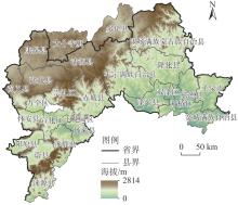
图1
北方农牧交错带中段数字高程模型 注:基于自然资源部标准地图服务网站审图号为GS(2024)0650号的标准地图制作,底图边界无修改。下同。"
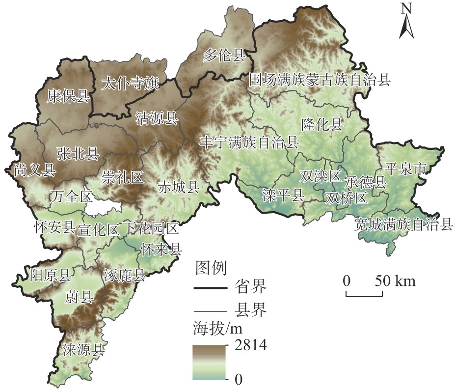

表1
新型城镇化质量评价指标体系"
| 类别层 | 指标层 | 单位 | 属性 | 指标解释 | 功能权重 |
|---|---|---|---|---|---|
| 人口城镇化 | 常住人口城镇化率 | % | 正向 | 城镇常住人口数占总人口数比例 | 0.29 |
| 第二、第三产业就业人数比重 | % | 正向 | 第二产业、第三产业就业人数占总就业人数比例 | ||
| 经济城镇化 | 人均GDP | 元·人-1 | 正向 | - | 0.26 |
| 城乡收入平衡指数 | % | 正向 | 城乡人均可支配收入比 | ||
| 第二、第三产业产值占比 | % | 正向 | 第二产业、第三产业产值占总产值比例 | ||
| 人均社会消费品零售额 | 元·人-1 | 正向 | - | ||
| 社会城镇化 | 卫生机构床位数 | 张 | 正向 | - | 0.24 |
| 普通中学在校人数 | 人 | 正向 | - | ||
| 全社会用电量 | 104 kWh | 正向 | - | ||
| 农业现代化 | 人均粮食产量 | kg·人-1 | 正向 | - | 0.21 |
| 设施农业占地面积 | hm2 | 正向 | - | ||
| 人均农林牧渔产值 | 元·人-1 | 正向 | - |
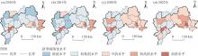
图2
2010—2023年北方农牧交错带中段地区新型城镇化水平空间分布"
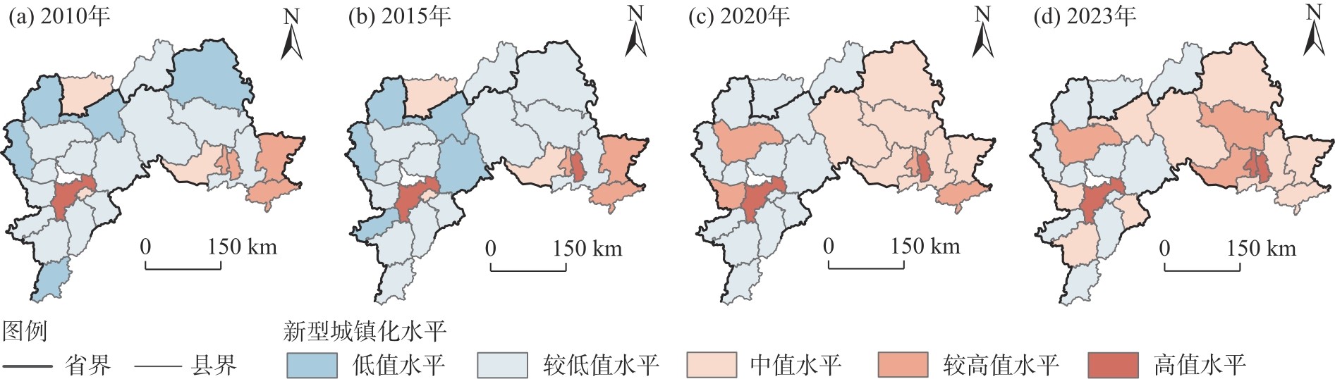
图3
2010—2023年北方农牧交错带中段地区新型城镇化水平冷热点空间分布"
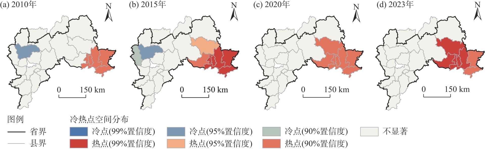
图4
2010—2023年北方农牧交错带中段地区农业生态系统服务价值空间分布"
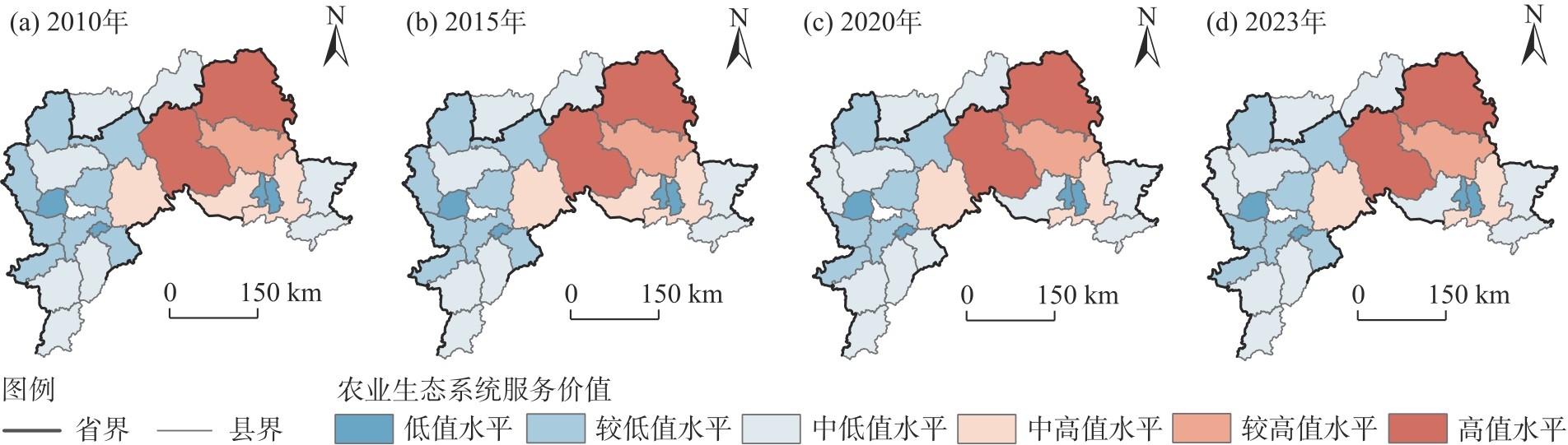
图5
2010—2023年北方农牧交错带中段地区农业生态系统服务价值冷热点空间分布"
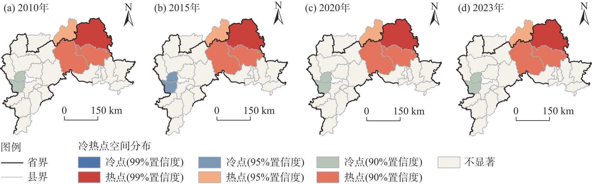
表2
新型城镇化与农业生态系统服务耦合协调度等级划分"
| 耦合协调度 | 耦合协调分级 | 耦合协调阶段 |
|---|---|---|
| 0.0~0.1 | 极度失调危机型 | 失调阶段 |
| 0.1~0.2 | 严重失调衰退型 | |
| 0.2~0.3 | 显著失调衰退型 | |
| 0.3~0.4 | 轻微失调衰退型 | 过渡阶段 |
| 0.4~0.5 | 濒临失调过渡型 | |
| 0.5~0.6 | 勉强协调过渡型 | |
| 0.6~0.7 | 基本协调发展型 | |
| 0.7~0.8 | 良好协调发展型 | 协调阶段 |
| 0.8~0.9 | 优质协调发展型 | |
| 0.9~1.0 | 完美协调示范型 |
图6
2010—2023年北方农牧交错带中段地区新型城镇化水平与农业生态系统服务价值耦合协调度空间分布"
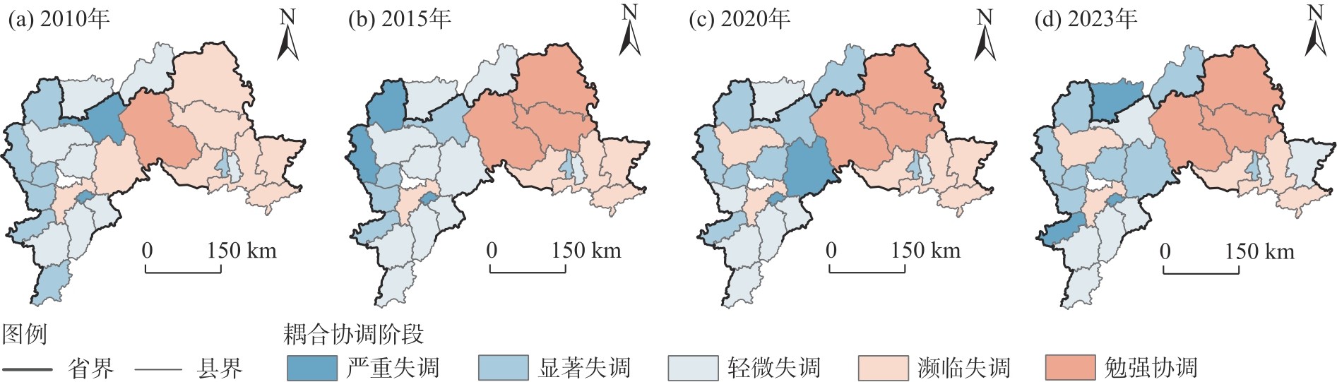
表3
耦合协调度空间分异驱动因子分析"
| 年份 | 因素类型 | 驱动因子 | 解释力 | P |
|---|---|---|---|---|
| 2010 | 社会经济类 | 人口密度 | 0.284 | 0.000** |
| 人均固定资产投资 | 0.092 | 0.000** | ||
| 人均存款余额 | 0.223 | 0.000** | ||
| 农业发展类 | 单位面积耕地农机效率 | 0.203 | 0.000** | |
| 人均耕地面积 | 0.348 | 0.000** | ||
| 自然条件类 | 年平均气温 | 0.133 | 0.000** | |
| 干燥度 | 0.232 | 0.000** | ||
| 2015 | 社会经济类 | 人口密度 | 0.146 | 0.000** |
| 人均固定资产投资 | 0.159 | 0.000** | ||
| 人均存款余额 | 0.132 | 0.000** | ||
| 农业发展类 | 单位面积耕地农机效率 | 0.516 | 0.000** | |
| 人均耕地面积 | 0.346 | 0.000** | ||
| 自然条件类 | 年平均气温 | 0.055 | 0.000** | |
| 干燥度 | 0.112 | 0.000** | ||
| 2020 | 社会经济类 | 人口密度 | 0.119 | 0.000** |
| 人均固定资产投资 | 0.128 | 0.000** | ||
| 人均存款余额 | 0.168 | 0.000** | ||
| 农业发展类 | 单位面积耕地农机效率 | 0.424 | 0.000** | |
| 人均耕地面积 | 0.402 | 0.000** | ||
| 自然条件类 | 年平均气温 | 0.171 | 0.000** | |
| 干燥度 | 0.189 | 0.000** | ||
| 2023 | 社会经济类 | 人口密度 | 0.158 | 0.000** |
| 人均固定资产投资 | 0.130 | 0.000** | ||
| 人均存款余额 | 0.137 | 0.000** | ||
| 农业发展类 | 单位面积耕地农机效率 | 0.278 | 0.000** | |
| 人均耕地面积 | 0.337 | 0.000** | ||
| 自然条件类 | 年平均气温 | 0.096 | 0.000** | |
| 干燥度 | 0.263 | 0.000** |
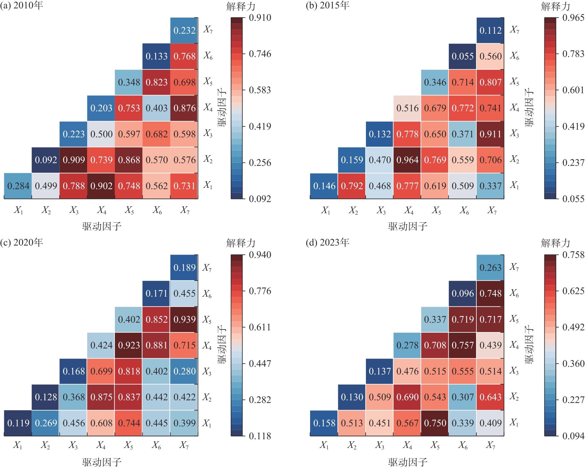
图7
交互探测器结果 注:X1、X2、X3、X4、X5、X6、X7分别为人口密度、人均固定资产投资、人均存款余额、单位面积耕地农机效率、人均耕地面积、年平均气温、干燥度。"
| [7] | [Cui Xiao, Wang Yongsheng, Shi Linna. Spatio-temporal characteristics and obstacle factors of human-land system coupling coordination in farming-pastoral ecotone of northern China[J]. Journal of Agricultural Resources and Environment, 2023, 40(1): 206-217.] |
| [8] | 白舒婷. 中国北方农牧交错带生态系统服务时空变化及权衡与协同研究[D]. 北京: 中国科学院大学, 2023. |
| [Bai Shuting. Spatio-temporal changes, trade-offs and synergies of ecosystem services in farming-pastoral ecotone of northern China[D]. Beijing: Chinese Academy of Sciences, 2023.] | |
| [9] | 农业农村部. 农业部关于北方农牧交错带农业结构调整的指导意见[J]. 中华人民共和国农业部公报, 2016(12): 7-12. |
| [Ministry of Agriculture and Rural Development. Guidelines of the ministry of agriculture on agricultural structural adjustment in the northern agricultural and animal husbandry intertwined belt[J]. Bulletin of the Ministry of Agriculture of the People’s Republic of China, 2016(12): 7-12.] | |
| [10] | 尚杰, 吉雪强, 陈玺名. 中国城镇化对农业生态效率的影响——基于中国13个粮食主产区2009—2018年面板数据[J]. 中国生态农业学报, 2020, 28(8): 1265-1276. |
| [Shang Jie, Ji Xueqiang, Chen Ximing. Study on the impact of China’s urbanization on agricultural ecological efficiency: Based on panel data of 13 major grain-producing regions in China from 2009 to 2018[J]. Chinese Journal of Eco-Agriculture, 2020, 28(8): 1265-1276.] | |
| [11] |
刘海猛, 方创琳, 李咏红. 城镇化与生态环境“耦合魔方”的基本概念及框架[J]. 地理学报, 2019, 74(8): 1489-1507.
doi: 10.11821/dlxb201908001 |
|
[Liu Haimeng, Fang Chuanglin, Li Yonghong. The coupled human and natural cube: A conceptual framework for analyzing urbanization and eco-environment interactions[J]. Acta Geographica Sinica, 2019, 74(8): 1489-1507.]
doi: 10.11821/dlxb201908001 |
|
| [12] |
魏伟, 段云生, 尹力, 等. 珠江流域地域主体功能时空演化特征及驱动机制[J]. 热带地理, 2024, 44(11): 1933-1948.
doi: 10.13284/j.cnki.rddl.20230393 |
|
[Wei Wei, Duan Yunsheng, Yin Li, et al. Spatio-temporal evolution characteristics and driving mechanism of regional main functional area in the Pearl River Basin[J]. Tropical Geography, 2024, 44(11): 1933-1948.]
doi: 10.13284/j.cnki.rddl.20230393 |
|
| [13] |
闫慧敏, 刘纪远, 黄河清, 等. 城市化和退耕还林草对中国耕地生产力的影响[J]. 地理学报, 2012, 67(5): 579-588.
doi: 10.11821/xb201205001 |
|
[Yan Huimin, Liu Jiyuan, Huang Heqing, et al. Impacts of cropland transformation on agricultural production under urbanization and grain for green project in China[J]. Acta Geographica Sinica, 2012, 67(5): 579-588.]
doi: 10.11821/xb201205001 |
|
| [14] | 田学斌. 实现人与自然和谐发展新境界——认真学习领会习近平总书记生态文明建设理念[J]. 社会科学战线, 2016(8): 1-14. |
| [Tian Xuebin. Achieving a new realm of harmonious development between humanity and nature: Conscientiously studying and understanding general secretary Xi Jinping’s idea of building an ecological civilization[J]. Social Science Front, 2016(8): 1-14.] | |
| [15] | 周忠学, 仇立慧. 城市化对生态系统服务功能影响的实证研究——以西安市南郊为例[J]. 干旱区研究, 2011, 28(6): 974-979. |
| [Zhou Zhongxue, Qiu Lihui. Experimental study on effect of urbanization on service functions of ecosystems: A case study in southern suburbs of Xi’an City[J]. Arid Zone Research, 2011, 28(6): 974-979.] | |
| [16] | 税伟, 付银, 林咏园, 等. 基于生态系统服务的城市生态安全评估、制图与模拟[J]. 福州大学学报(自然科学版), 2019, 47(2): 143-152. |
| [Shui Wei, Fu Yin, Lin Yongyuan, et al. Urban ecological security assessment,mapping and simulation based on ecosystem services[J]. Journal of Fuzhou University (Natural Science Edition), 2019, 47(2): 143-152.] | |
| [17] |
隋明强, 黄奕晗, 哈梅芳. 宁夏新型城镇化与生态环境建设脱钩关系及驱动因素研究[J]. 地域研究与开发, 2025, 44(2): 72-77, 92.
doi: 10.3969/j.issn.1003-2363.2025.02.009 |
|
[Sui Mingqiang, Huang Yihan, Ha Meifang. Research on decoupling relationship and driving factors between new urbanization and ecological environment construction in Ningxia[J]. Areal Research and Development, 2025, 44(2): 72-77, 92.]
doi: 10.3969/j.issn.1003-2363.2025.02.009 |
|
| [18] | 邓楚雄, 朱大美, 李忠武, 等. 湘中丘陵区农业生态系统服务价值与城镇化水平弹性关系研究[J]. 中国生态农业学报, 2021, 29(8): 1453-1466. |
| [1] |
邓宗兵, 宗树伟, 苏聪文, 等. 长江经济带生态文明建设与新型城镇化耦合协调发展及动力因素研究[J]. 经济地理, 2019, 39(10): 78-86.
doi: 10.15957/j.cnki.jjdl.2019.10.011 |
|
[Deng Zongbing, Zong Shuwei, Su Congwen, et al. Research on coupling coordination development between ecological civilization construction and new urbanization and its driving forces in the Yangtze River Economic Zone[J]. Economic Geography, 2019, 39(10): 78-86.]
doi: 10.15957/j.cnki.jjdl.2019.10.011 |
|
| [2] | 国务院. 国家新型城镇化规划(2014—2020年)[EB/OL]. [2014-03-16]. https://www.gov.cn/gongbao/content/2014/content_2644805.html. |
| [The State Council. National new urbanisation plan (2014—2020)[EB/OL]. [2014-03-16]. https://www.gov.cn/gongbao/content/2014/content_2644805.html.] | |
| [3] | 杨正勇, 杨怀宇, 郭宗香. 农业生态系统服务价值评估研究进展[J]. 中国生态农业学报, 2009, 17(5): 1045-1050. |
|
[Yang Zheng-yong, Yang Huaiyu, Guo Zongxiang. A literature review on evaluation of agricultural ecosystem services[J]. Chinese Journal of Eco-Agriculture, 2009, 17(5): 1045-1050.]
doi: 10.3724/SP.J.1011.2009.01045 |
|
| [4] | 高嫄, 原野, 赵艺芳. 基于生态系统服务供需的农牧交错带流域生态修复分区——以桑干河上游为例[J]. 环境工程技术学报, 2023, 13(3): 1214-1222. |
| [Gao Yuan, Yuan Ye, Zhao Yifang. Ecological restoration zoning in farming-grazing transitional zone based on thesupply and demand of the ecosystem services: A case study of the upper reaches of the Sanggan River[J]. Journal of Environmental Engineering Technology, 2023, 13(3): 1214-1222.] | |
| [5] | 马力阳, 李同昇, 李婷, 等. 我国北方农牧交错带县域乡村性空间分异及其发展类型[J]. 经济地理, 2015, 35(9): 126-133. |
| [Ma Liyang, Li Tongsheng, Li Ting, et al. Spatial distribution of rurality and types of rural developmentin farming-pastoral ecotone in northern China[J]. Economic Geography, 2015, 35(9): 126-133.] | |
| [6] |
陶泽涪, 王世清, 孙丕苓, 等. 中国北方农牧交错带耕地时空分异及驱动因素[J]. 干旱区地理, 2022, 45(1): 153-163.
doi: 10.12118/j.issn.1000–6060.2021.153 |
|
[Tao Zepei, Wang Shiqing, Sun Piling, et al. Spatio-temporal differentiation and driving factors of cropland in the agro-pastoral ecotone of northern China[J]. Arid Land Geography, 2022, 45(1): 153-163.]
doi: 10.12118/j.issn.1000–6060.2021.153 |
|
| [7] | 崔潇, 王永生, 施琳娜. 北方农牧交错带人地系统耦合协调的时空特征及障碍因子[J]. 农业资源与环境学报, 2023, 40(1): 206-217. |
| [18] | [Deng Chuxiong, Zhu Damei, Li Zhongwu, et al. Estimation of elasticity relationship between agricultural ecosystem service values and urbanization[J]. Chinese Journal of Eco-Agriculture, 2021, 29(8): 1453-1466.] |
| [19] |
胡其玉, 陈松林. 基于生态系统服务供需的厦漳泉地区生态网络空间优化[J]. 自然资源学报, 2021, 36(2): 342-355.
doi: 10.31497/zrzyxb.20210206 |
|
[Hu Qiyu, Chen Songlin. Optimizing the ecological networks based on thesupply and demand of ecosystem services in Xiamen-Zhangzhou-Quanzhou region[J]. Journal of Natural Resources, 2021, 36(2): 342-355.]
doi: 10.31497/zrzyxb.20210206 |
|
| [20] | 段维利, 余新晓, 陈丽华, 等. 京津冀城市群城镇化与生态建设对生态系统服务价值的影响[J]. 水土保持研究, 2023, 30(4): 404-411. |
| [Duan Weili, Yu Xinxiao, Chen Lihua, et al. Impact of urbanization and ecological construction on the ecosystem services value in the Beijing-Tianjin-Hebei urban agglomeration[J]. Research of Soil and Water Conservation, 2023, 30(4): 404-411.] | |
| [21] | 韩磊, 高毅丰, 常钰卿, 等. 黄土高原城镇化与生态系统服务脱钩关系[J]. 生态学报, 2024, 44(20): 9108-9121. |
| [Han Lei, Gao Yifeng, Chang Yuqing, et al. Decoupling relationship between urbanisation and ecosystem services on the Loess Plateau[J]. Acta Ecologica Sinica, 2024, 44(20): 9108-9121.] | |
| [22] | 路昌, 王雨晴, 刘晓丽. 黄河下游地区新型城镇化与生态系统服务耦合分析[J]. 生态经济, 2023, 39(9): 85-92. |
|
[Lu Chang, Wang Yuqing, Liu Xiaoli. Coupling relationship between new urbanization and ecosystem services: A case of lower Yellow River[J]. Ecological Economy, 2023, 39(9): 85-92.]
doi: 10.1016/S0921-8009(01)00195-1 |
|
| [23] |
赵哈林, 赵学勇, 张铜会, 等. 北方农牧交错带的地理界定及其生态问题[J]. 地球科学进展, 2002, 17(5): 739-747.
doi: 10.11867/j.issn.1001-8166.2002.05.0739 |
| [Zhao Halin, Zhao Xueyong, Zhang Tonghui, et al. Boundary line on agro-pasture zigzag zone in north China and its problems on eco-environment[J]. Advance in Earth Sciences, 2002, 17(5): 739-747.] | |
| [24] |
Friedmann J. Four theses in the study of China’s urbanization[J]. International Journal of Urban and Regional Research, 2006, 30(2): 440-451.
doi: 10.1111/ijur.2006.30.issue-2 |
| [25] |
李汝资, 黄晓玲, 刘耀彬. 2010—2020年中国城镇化的时空分异及影响因素[J]. 地理学报, 2023, 78(4): 777-791.
doi: 10.11821/dlxb202304001 |
|
[Li Ruzi, Huang Xiaoling, Liu Yaobin. Spatio-temporal differentiation and influencing factors of China’s urbanization from 2010 to 2020[J]. Acta Geographica Sinica, 2023, 78(4): 777-791.]
doi: 10.11821/dlxb202304001 |
|
| [26] | 熊曦, 肖俊. 武陵山片区城镇化与生态环境耦合协调度时空分异——以六个中心城市为例[J]. 生态学报, 2021, 41(15): 5973-5987. |
| [Xiong Xi, Xiao Jun. Evaluation of coupling coordination between urbanization and eco-environment insix central cities, Wuling Mountain area[J]. Acta Ecologica Sinica, 2021, 41(15): 5973-5987.] | |
| [27] |
施金里, 徐丽萍, 李晓航, 等. 南疆县域生态-经济协调性评估及可持续发展分区[J]. 干旱区地理, 2024, 47(10): 1794-1804.
doi: 10.12118/j.issn.1000-6060.2023.738 |
|
[Shi Jinli, Xu Liping, Li Xiaohang, et al. Evaluation of ecological-economic harmony and sustainable development zoning in counties of southern Xinjiang[J]. Arid Land Geography, 2024, 47(10): 1794-1804.]
doi: 10.12118/j.issn.1000-6060.2023.738 |
|
| [28] |
Costanza R, d’Arge R, de Groot R, et al. The value of the world’s ecosystem services and natural capital[J]. Nature, 1997, 387(6630): 253-260.
doi: 10.1038/387253a0 |
| [29] | 谢高地, 甄霖, 鲁春霞, 等. 一个基于专家知识的生态系统服务价值化方法[J]. 自然资源学报, 2008, 23(5): 911-919. |
|
[Xie Gaodi, Zhen Lin, Lu Chunxia, et al. Expert knowledge based valuation method of ecosystem services in China[J]. Journal of Natural Resources, 2008, 23(5): 911-919.]
doi: 10.11849/zrzyxb.2008.05.019 |
|
| [30] | 谢高地, 肖玉, 甄霖, 等. 我国粮食生产的生态服务价值研究[J]. 中国生态农业学报 (中英文), 2005, 13(3): 10-13. |
| [Xie Gaodi, Xiao Yu, Zhen Lin, et al. Study on ecosystem services value of food production in China[J]. Chinese Journal of Eco-Agriculture, 2005, 13(3): 10-13.] | |
| [31] | Shi T, Yang S Y, Zhang W, et al. Coupling coordination degree measurement and spatiotemporal heterogeneity between economic development and ecological environment: Empirical evidence from tropical and subtropical regions of China[J]. Journal of Cleaner Production, 2020, 244: 118739, doi: 10.1016/j.jclepro.2019.118739. |
| [32] |
王劲峰, 徐成东. 地理探测器: 原理与展望[J]. 地理学报, 2017, 72(1): 116-134.
doi: 10.11821/dlxb201701010 |
|
[Wang Jinfeng, Xu Chengdong. Geodetector: Principle and prospective[J]. Acta Geographica Sinica, 2017, 72(1): 116-134.]
doi: 10.11821/dlxb201701010 |
|
| [33] | 聂名萱, 黄思华, 濮励杰, 等. 快速城镇化地区生态系统服务的时空动态及权衡与协同分析: 以苏锡常地区为例[J]. 长江流域资源与环境, 2021, 30(5): 1088-1099. |
| [Nie Mingxuan, Huang Sihua, Pu Lijie, et al. Spatial and temporal dynamics and trade-offs and synergies analysis of ecosystem services in rapidly urbanizing areas: A case study of the Su-Xi-Chang region[J]. Resources and Environment in the Yangtze Basin, 2021, 30(5): 1088-1099.] | |
| [34] | 李锋, 叶亚平, 宋博文, 等. 城市生态用地的空间结构及其生态系统服务动态演变——以常州市为例[J]. 生态学报, 2011, 31(19): 5623-5631. |
| [Li Feng, Ye Yaping, Song Bowen, et al. Spatial structure of urban ecological land and its dynamic development of ecosystem services: A case study in Changzhou City, China[J]. Acta Ecologica Sinica, 2011, 31(19): 5623-5631.] | |
| [35] |
刘海龙, 王改艳, 张鹏航, 等. 汾河流域新型城镇化与生态韧性耦合协调时空演变及协调影响力研究[J]. 自然资源学报, 2024, 39(3): 640-667.
doi: 10.31497/zrzyxb.20240309 |
|
[Liu Hailong, Wang Gaiyan, Zhang Penghang, et al. Spatio-temporal evolution and coordination influence of coupling coordination between new urbanization and ecological resilience in Fenhe River Basin[J]. Journal of Natural Resources, 2024, 39(3): 640-667.]
doi: 10.31497/zrzyxb.20240309 |
|
| [36] |
冯雨雪, 李广东. 青藏高原城镇化与生态环境交互影响关系分析[J]. 地理学报, 2020, 75(7): 1386-1405.
doi: 10.11821/dlxb202007005 |
|
[Feng Yuxue, Li Guangdong. Interaction between urbanization and eco-environment in Tibetan Plateau[J]. Acta Geographica Sinica, 2020, 75(7): 1386-1405.]
doi: 10.11821/dlxb202007005 |
|
| [37] |
李小建, 文玉钊, 李元征, 等. 黄河流域高质量发展: 人地协调与空间协调[J]. 经济地理, 2020, 40(4): 1-10.
doi: 10.15957/j.cnki.jjdl.2020.04.001 |
|
[Li Xiaojian, Wen Yuzhao, Li Yuanzheng, et al. High-quality development of the Yellow River Basin from a perspective of economic geography: Man-land and spatial coordination[J]. Economic Geography, 2020, 40(4): 1-10.]
doi: 10.15957/j.cnki.jjdl.2020.04.001 |
|
| [38] |
罗小梅, 文琦, 施琳娜, 等. 多维视角下中国北方农牧交错带县域收缩识别及影响因素分析[J]. 干旱区地理, 2025, 48(7): 1267-1278.
doi: 10.12118/j.issn.1000-6060.2024.431 |
|
[Luo Xiaomei, Wen Qi, Shi Linna, et al. Identification of county shrinkage and its driving factors in agro-pastoral zone of north China from a multidimensional perspective[J]. Arid Land Geography, 2025, 48(7): 1267-1278.]
doi: 10.12118/j.issn.1000-6060.2024.431 |
| [1] | 陈先林, 闫志远, 刘全明, 张圣微. 1958—2023年内蒙古植被干旱时空特征与驱动因素分析[J]. 干旱区地理, 2026, 49(7): 1323-1335. |
| [2] | 李文君, 张维梅. 中国数字经济与共同富裕的耦合协调关系及时空演进趋势[J]. 干旱区地理, 2026, 49(7): 1481-1492. |
| [3] | 朱怡婷, 杜跃, 周雨乾, 何雄, 周春山, 陈泓睿. 基于社交媒体数据的“网红打卡地”空间特征及影响因素[J]. 干旱区地理, 2026, 49(6): 1264-1276. |
| [4] | 吕宛青, 宋志高, 肖钊富. 中国新型城镇化与旅游业高质量发展耦合协调、障碍诊断及驱动因素[J]. 干旱区地理, 2026, 49(5): 1063-1073. |
| [5] | 贾亚娟, 高君, 张新奇. 关中平原耕地利用生态效率时空演化及驱动因素分析[J]. 干旱区地理, 2026, 49(4): 830-840. |
| [6] | 曹浩然, 孟梅, 刘红光. 2000—2024年甘肃省土地生态脆弱性时空变化特征及模拟预测研究[J]. 干旱区地理, 2026, 49(4): 841-855. |
| [7] | 张志秀, 马彩虹. 链谱视角下干旱海湾国家土地利用变化特征及驱动因子分析——以卡塔尔为例[J]. 干旱区地理, 2026, 49(4): 868-879. |
| [8] | 王伟军, 李娟, 李花. 黄河流域旅游-生态-福祉耦合协调的多尺度时空演化及分异机理[J]. 干旱区地理, 2026, 49(4): 683-696. |
| [9] | 王慧丽, 李妞, 刘英, 刘咏涵. 黄河流域水资源-生态韧性动态耦合与级层障碍解析[J]. 干旱区地理, 2026, 49(3): 569-580. |
| [10] | 李骞国, 孙龙凯, 惠蕃艳, 朱宗斌. 甘肃省县域乡村韧性时空演变特征及驱动机制研究[J]. 干旱区地理, 2026, 49(2): 393-403. |
| [11] | 欧开航, 方世巧, 程乾, 周徐帆. 农村公共服务与乡村旅游耦合协调度及其乡村振兴影响效应——基于西部地区的实证[J]. 干旱区地理, 2026, 49(2): 404-415. |
| [12] | 孙国军, 李家瑶, 王子轩. 黄河流域数文旅产业发展水平评价与耦合协调时空特征分析[J]. 干旱区地理, 2026, 49(1): 117-127. |
| [13] | 王雅俊, 王一峰. 宁夏易地扶贫搬迁安置区融入新型城镇化效果评价及影响因素[J]. 干旱区地理, 2026, 49(1): 186-197. |
| [14] | 徐建斌, 曹小曙. 宁夏小流域尺度水土资源耦合特征及影响因素[J]. 干旱区地理, 2025, 48(9): 1531-1540. |
| [15] | 王晓菲, 邳华伟, 李思思. 青藏高原土壤风蚀潜力时空特征及驱动因素分析[J]. 干旱区地理, 2025, 48(9): 1589-1599. |
|
||

