干旱区地理 ›› 2026, Vol. 49 ›› Issue (2): 265-274.doi: 10.12118/j.issn.1000-6060.2025.122 cstr: 32274.14.ALG2025122
曾勇1,2( ), 毕钰1,2, 张洪彬1,2, 施枫芝3, 王鹏3()
收稿日期:2025-03-10
修回日期:2025-04-23
出版日期:2026-02-25
发布日期:2026-02-27
通讯作者:
王鹏(1987-),男,硕士,助理工程师,主要从事绿洲生态等方面的研究. E-mail: wangp@ms.xjb.ac.cn作者简介:曾勇(1988-),女,博士研究生,高级实验师,主要从事绿洲生态建设与规划等方面的研究. E-mail: zengyong107@sina.cn
基金资助:
ZENG Yong1,2(), BI Yu1,2, ZHANG Hongbin1,2, SHI Fengzhi3, WANG Peng3()
Received:2025-03-10
Revised:2025-04-23
Published:2026-02-25
Online:2026-02-27
摘要:
以塔里木河流域为研究区,基于Landsat遥感影像和社会经济数据,运用Flus-Markov模型和当量因子法,分析2012—2032年土地利用格局动态变化,评估生态系统服务价值(Ecosystem service value,ESV)的时空特征,进而预测其未来变化趋势。结果表明:(1) 2012—2032年未利用地和水域面积先减后增,耕地持续扩张,草地显著退化,导致ESV总量下降2093.72×108元,其中草地和水域贡献分别下降2984.17×108元和38.44×10⁸元。(2) ESV空间分布呈现西北高、东南低特征,水文调节、气候调节及气体调节为关键服务功能。(3) 敏感性分析显示,水域和草地变化对ESV影响最大,但价值系数修正的弹性较低,表明估算结果稳健。模型验证显示Kappa系数达0.95,预测精度可靠。(4) 土地利用以及归一化植被指数是影响塔里木河流域生态系统服务价值的主要影响因子。研究揭示塔里木河流域生态服务功能退化与土地利用扩张的关联性,建议通过优化土地利用结构、强化草地和水域保护以提升ESV,为干旱区生态安全与可持续发展提供科学依据。
曾勇, 毕钰, 张洪彬, 施枫芝, 王鹏. 塔里木河流域生态系统服务价值与土地利用的动态变化[J]. 干旱区地理, 2026, 49(2): 265-274.
ZENG Yong, BI Yu, ZHANG Hongbin, SHI Fengzhi, WANG Peng. Dynamic changes of ecosystem service value and land use in the Tarim River Basin[J]. Arid Land Geography, 2026, 49(2): 265-274.
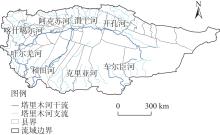
图1
研究区示意图"
表1
数据来源及信息"
| 数据类型 | 数据名称 | 数据来源 |
|---|---|---|
| 基础数据 | 遥感影像数据 (2012、2022年) | 美国地勘局(USGS)网站 ( |
| 道路数据 | OpenstreetMap ( | |
| 行政边界数据 | 国家地理信息公共服务平台 ( | |
| 社会经济 数据 | 人口数据 | Worldpop( |
| GDP | 新疆维吾尔自治区统计局 ( | |
| 夜间灯光指数 | Earth observation group ( | |
| 粮食平均收购价格 | 新疆维吾尔自治区统计局 ( | |
| 粮食作物产量 | 新疆维吾尔自治区统计局 ( | |
| 气候环境 数据 | 气温 | 青藏高原数据中心 ( |
| 年总降水量 | 青藏高原数据中心 ( | |
| 高程 | 地理空间数据云 ( | |
| 归一化植被指数(NDVI) | 美国航空航天局 ( |
表2
交互关系"
| 交互作用类型 | 比较 |
|---|---|
| q(x1∩x2)<Min[q(x1),q(x2)] | 非线性减弱 |
| Min[q(x1),q(x2)]<q(x1∩x2)<Max[q(x1),q(x2)] | 单因子非线性减弱 |
| q(x1∩x2)>Max[q(x1),q(x2)] | 双因子增强 |
| q(x1∩x2)=q(x1)+q(x2) | 独立 |
| q(x1∩x2)>q(x1)+q(x2) | 非线性增强 |
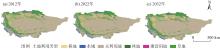
图2
2012—2032年塔里木河流域土地利用"
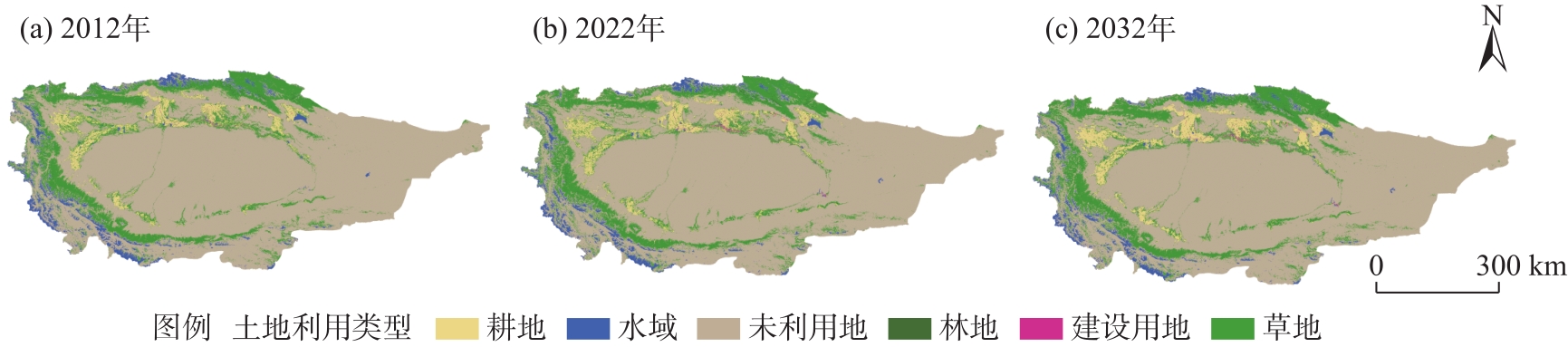
表3
2012—2032年塔里木河流域土地利用面积变化"
| 年份 | 土地利用类型 | |||||
|---|---|---|---|---|---|---|
| 耕地 | 林地 | 草地 | 水域 | 建设 用地 | 未利 用地 | |
| 2012 | 4.82 | 0.14 | 20.38 | 4.23 | 0.21 | 93.97 |
| 2022 | 5.30 | 0.18 | 20.46 | 3.70 | 0.33 | 93.80 |
| 2032 | 5.65 | 0.15 | 19.46 | 4.23 | 0.31 | 93.97 |
| 2012—2022 | 0.48 | 0.04 | 0.07 | -0.53 | 0.11 | -0.17 |
| 2022—2032 | 0.35 | -0.03 | -1.00 | 0.53 | -0.02 | 0.17 |

图3
2012—2032年塔里木河流域土地利用变化"
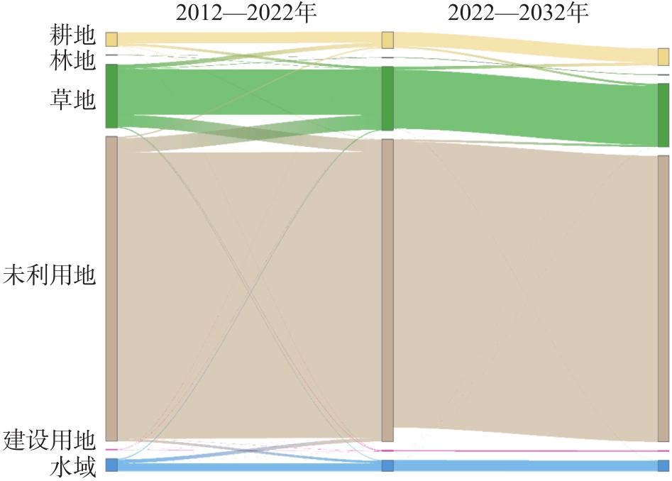
表4
2012—2032年土地利用类型生态系统服务价值"
| 土地利 用类型 | 2012年 | 2022年 | 2032年 | 2012—2032年 | 变化趋势 |
|---|---|---|---|---|---|
| 耕地 | 5223.65 | 5739.72 | 6119.79 | 896.13 | 上升 |
| 林地 | 743.15 | 915.00 | 763.40 | 20.25 | 上升 |
| 草地 | 65506.60 | 65760.50 | 62522.40 | -2984.17 | 下降 |
| 水域 | 75343.70 | 65730.80 | 75305.20 | -38.44 | 下降 |
| 建设用地 | 25.60 | 39.98 | 37.85 | 12.25 | 上升 |
| 未利用地 | 16096.80 | 16051.50 | 16097.10 | 0.25 | 上升 |
表5
土地利用类型单项生态系统服务价值"
| 服务类型 | 耕地 | 林地 | 草地 | 水域 | 建设用地 | 未利用地 | 总和 | |
|---|---|---|---|---|---|---|---|---|
| 供给服务 | 食物生产 | 2942.88 | 672.47 | 621.44 | 1163.04 | 0.00 | 13.32 | 5413.14 |
| 原料生产 | 652.49 | 1544.68 | 914.38 | 648.06 | 0.00 | 39.95 | 3799.56 | |
| 水资源供给 | -2756.45 | 639.18 | 506.02 | 11576.21 | 0.00 | 26.63 | 9991.58 | |
| 调节服务 | 气体调节 | 2370.28 | 5080.13 | 3213.65 | 11576.21 | 53.26 | 173.11 | 22466.65 |
| 气候调节 | 1238.41 | 15200.43 | 8495.73 | 5708.21 | 0.00 | 133.16 | 30775.94 | |
| 净化环境 | 359.54 | 4454.27 | 2805.28 | 8264.92 | 266.32 | 545.96 | 16696.29 | |
| 水文调节 | 3582.06 | 8988.43 | 6223.10 | 118602.91 | 772.34 | 319.59 | 138488.43 | |
| 支持服务 | 土壤保持 | 1384.88 | 6185.37 | 3914.96 | 2876.30 | 53.26 | 199.74 | 14614.52 |
| 养分循环 | 412.80 | 472.72 | 310.71 | 2219.38 | 0.00 | 13.32 | 3428.94 | |
| 生物多样性 | 452.75 | 5632.75 | 3559.86 | 9259.19 | 53.26 | 186.43 | 19144.25 | |
| 文化服务 | 美学景观 | 199.74 | 2470.15 | 1571.31 | 5956.78 | 26.63 | 79.90 | 10304.51 |
图4
塔里木河流域县级生态系统服务价值"
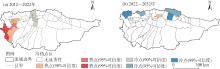
图5
塔里木河流域生态系统服务价值冷热点空间分布"

表6
塔里木河流域生态系统服务价值敏感性指数"
| 土地利用类型 | 2012年 | 2022年 | 2032年 |
|---|---|---|---|
| 耕地 | 0.1356 | 0.0356 | 0.0380 |
| 林地 | 0.0041 | 0.0059 | 0.0047 |
| 草地 | 0.3590 | 0.4271 | 0.3887 |
| 水域 | 0.4129 | 0.4269 | 0.4682 |
| 建设用地 | 0.0001 | 0.0003 | 0.0002 |
| 未利用地 | 0.0882 | 0.1042 | 0.1001 |
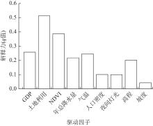
图6
塔里木河流域生态系统服务价值单因子探测结果 注:NDVI为归一化植被指数。下同。"

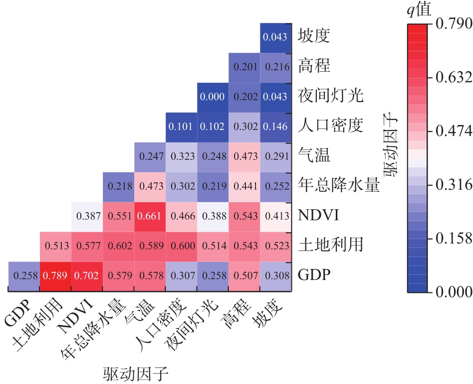
图7
塔里木河流域生态系统服务价值交互作用探测结果"
| [1] | 张睿婕, 余侃华, 司文虎. 生态补偿驱动下陕西省生态系统服务价值时空演变特征研究[J]. 现代城市研究, 2025(4): 103-110. |
| [Zhang Ruijie, Yu Kanhua, Si Wenhu. Spatiotemporal evolution of ecosystem service values in Shaanxi Province driven by ecological compensation[J]. Modern Urban Research, 2025(4): 103-110.] | |
| [2] |
李岩, 吴浩, 朱连奇, 等. 基于土地利用变化多情景模拟的郑州市生态系统服务退化风险识别及其启示[J]. 自然资源学报, 2025, 40(2): 493-513.
doi: 10.31497/zrzyxb.20250213 |
|
[Li Yan, Wu Hao, Zhu Lianqi, et al. Identification of ecosystem service degradation risks in Zhengzhou based on multi-scenario simulation of land use changes[J]. Journal of Natural Resources, 2025, 40(2): 493-513.]
doi: 10.31497/zrzyxb.20250213 |
|
| [3] | Wang Y, Zhang S, Zhen H, et al. Spatiotemporal evolution characteristics in ecosystem service values based on land use/cover change in the Tarim River Basin, China[J]. Sustainability, 2020, 12(18): 7759, doi: 10.3390/su12187759. |
| [4] |
刘芦萌, 邬建国. 生态系统服务与人类福祉关系的研究框架、途径与方法[J]. 自然资源学报, 2024, 39(9): 2044-2065.
doi: 10.31497/zrzyxb.20240903 |
|
[Liu Lumeng, Wu Jianguo. Frameworks, approaches, and methods for stud-ying the relationship between ecosystem services and human wellbeing[J]. Journal of Natural Resources, 2024, 39(9): 2044-2065.]
doi: 10.31497/zrzyxb.20240903 |
|
| [5] | 谢高地, 林智钦. 生态系统资产与服务评估核算研究[J]. 中国软科学, 2024(增刊1): 388-393. |
| [Xie Gaodi, Lin Zhiqin. Research on evaluation and accounting of ecosystem assets and services[J]. China Soft Science Magazine, 2024(Suppl. 1): 388-393.] | |
| [6] | 肖霄, 杨思明, 刘金凤, 等. 基于生态系统服务价值的流域生态补偿研究——以福建省南平市为例[J]. 能源与环境, 2025(2): 151-154. |
| [Xiao Xiao, Yang Siming, Liu Jinfeng, et al. Research on watershed ecological compensation based on ecosystem service value: A case study of Nanping City, Fujian Province[J]. Energy and Environment, 2025(2): 151-154.] | |
| [7] | 焦娇, 刘清洋, 达拉, 等. 基于土地利用变化的西藏玉曲河流域生态系统服务价值研究[J]. 环境生态学, 2025, 7(3): 84-90. |
| [Jiao Jiao, Liu Qingyang, Dara, et al. Study on ecosystem service value Yuqu River Basin in Tibet based on land use change[J]. Environmental Ecology, 2025, 7(3): 84-90.] | |
| [8] | 安志英, 孙才志, 郝帅. 我国东北生态系统服务供需匹配关系——基于水-能源-粮食纽带视角[J]. 生态学报, 2024, 44(10): 4170-4186. |
| [An Zhiying, Sun Caizhi, Hao Shuai. Matching relationship between supply and demand of ecosystem services from the perspective of water-energy-food nexus in northeast China[J]. Acta Ecologica Sinica, 2024, 44(10): 4170-4186.] | |
| [9] | 刘玥含, 金爱博, 王向荣. 昆明市生态系统服务多情景模拟评估——基于GMOP-PLUS模型分析[J]. 中国城市林业, 2025, 23(1): 143-152. |
| [Liu Yuehan, Jin Aibo, Wang Xiangrong. Multi-scenario modeling assessment of ecosystem services in Kunming based on GMOP-PLUS model[J]. Journal of Chinese Urban Forestry, 2025, 23(1): 143-152.] | |
| [10] | 张伟, 杜培军, 郭山川, 等. 改进型遥感生态指数及干旱区生态环境评价[J]. 遥感学报, 2023, 27(2): 299-317. |
|
[Zhang Wei, Du Peijun, Guo Shanchuan, et al. Enhanced remote sensing ecological index and ecological environment evaluation in arid area[J]. National Remote Sensing Bulletin, 2023, 27(2): 299-317.]
doi: 10.11834/jrs.20221527 |
|
| [11] | 杨舒慧, 崔雪锋. 新疆生态区的生态系统服务的时空变化特征分析[J]. 气候与环境研究, 2024, 29(3): 302-316. |
| [Yang Shuhui, Cui Xuefeng. Characteristics of spatiotemporal changes in ecosystem services in Xinjiang ecological zones[J]. Climatic and Environmental Research, 2024, 29(3): 302-316.] | |
| [12] |
王洋, 冯卓亚, 许丽, 等. 塔里木河流域生境质量与土地利用变化响应及驱动力[J]. 干旱区研究, 2024, 41(12): 2132-2142.
doi: 10.13866/j.azr.2024.12.14 |
|
[Wang Yang, Feng Zhuoya, Xu Li, et al. Response and influencing factors of habitat quality and land use change in the Tarim River Basin[J]. Arid Zone Research, 2024, 41(12): 2132-2142.]
doi: 10.13866/j.azr.2024.12.14 |
|
| [13] | 张俊兰, 杨霞, 肖俊安, 等. 昆仑山北部夏季降水多尺度时空变化特征[J]. 高原山地气象研究, 2023, 43(3): 1-10. |
| [Zhang Junlan, Yang Xia, Xiao Jun’an, et al. Multi-scale temporal and spatial variation characteristics of summer precipitation in northern Kunlun Mountains[J]. Plateau and Mountain Meteorology Research, 2023, 43(3): 1-10.] | |
| [14] |
杨黎敏, 王坤鹏, 易家林, 等. 耦合生态系统服务的社会生态风险分析框架[J]. 应用生态学报, 2024, 35(5): 1419-1425.
doi: 10.13287/j.1001-9332.202405.019 |
|
[Yang Limin, Wang Kunpeng, Yi Jialin, et al. Socio-ecological risk analysis framework coupled with ecosystem services[J]. Chinese Journal of Applied Ecology, 2024, 35(5): 1419-1425.]
doi: 10.13287/j.1001-9332.202405.019 |
|
| [15] | 姚俊飞, 吴发亮, 魏国良, 等. 基于格网尺度的三江源土地利用变化及生态系统服务价值时空相关性分析[J]. 青海科技, 2025, 32(1): 7-19. |
| [Yao Junfei, Wu Faliang, Wei Guoliang, et al. Analysis of the spatiotemporal correlation of land use change and ecosystem service value in the Sanjiangyuan region based on grid scale[J]. Qinghai Science and Technology, 2025, 32(1): 7-19.] | |
| [16] | 罗万云, 孙慧, 钟方雷, 等. 额尔齐斯河流域土地利用变化对生态系统服务价值损益时空演变的影响[J]. 水土保持通报, 2022, 42(4): 301-311. |
| [Luo Wanyun, Sun Hui, Zhong Fanglei, et al. Effects of land use change on spatio temporal evolution of ecosystem service value profit and loss in lrtysh River Basin[J]. Bulletin of Soil and Water Conservation, 2022, 42(4): 301-311.] | |
| [17] | 王舒影, 杨国福, 徐依仁, 等. 杭州乡村景观格局对生态系统服务的空间影响[J]. 风景园林, 2025, 32(4): 125-132. |
| [Wang Shuying, Yang Guofu, Xu Yiren, et al. Spatial impact of rural landscape pattern on ecosystem service in Hangzhou[J]. Landscape Architecture, 2025, 32(4): 125-132.] | |
| [18] | 王晓璐, 王承武, 蒯欣冉, 等. 乌鲁木齐市土地利用景观格局演变及其生态效应[J]. 中南农业科技, 2025, 46(4): 105-110. |
| [Wang Xiaolu, Wang Chengwu, Kuai Xinran, et al. Evolution of land use landscape pattern and its ecological effects in Urumqi City[J]. South-Central Agricultural Science and Technology, 2025, 46(4): 105-110.] | |
| [19] | 冯起, 白光祖, 李宗省, 等. 加快构建西北地区生态保护新格局[J]. 中国科学院院刊, 2022, 37(10): 1457-1470. |
| [Feng Qi, Bai Guangzu, Li Zongsheng, et al. Accelerate construction of new pattern of ecological protection in northwest China[J]. Bulletin of Chinese Academy of Sciences, 2022, 37(10): 1457-1470.] | |
| [20] |
黄秋淞, 何浩. 耦合生态系统服务和景观连通性的环塔里木盆地绿洲区生态安全格局研究[J]. 干旱区地理, 2024, 47(10): 1745-1754.
doi: 10.12118/j.issn.1000-6060.2024.022 |
|
[Huang Qiusong, He Hao. Ecological security pattern of the oasis area around the Tarim Basin based on coupled ecosystem services and landscape connectivity[J]. Arid Land Geography, 2024, 47(10): 1745-1754.]
doi: 10.12118/j.issn.1000-6060.2024.022 |
|
| [21] | 巴音达拉, 李江, 张环, 等. 塔里木河流域生态廊道植被覆盖时空变化研究[J]. 水利规划与设计, 2025(3): 1-8. |
| [Bayindala, Li Jiang, Zhang Huan, et al. Spatiotemporal changes of vegetation cover in ecological corridors of the Tarim River Basin[J]. Water Resources Planning and Design, 2025(3): 1-8.] | |
| [22] | Chen Y, Chen Y, Zhu C, et al. Ecohydrological effects of water conveyance in a disconnected river in an arid inland river basin[J]. Scientific Reports, 2022, 12(1): 9982, doi: 10.1038/s41598-022-14524-z. |
| [23] | 周源涛, 曲书锋, 张国明. 基于国家安全视角的生态安全问题研究进展与思考——以西部典型生态脆弱区为例[J]. 社会治理, 2025(2): 43-59. |
| [Zhou Yuantao, Qu Shufeng, Zhang Guoming. Research progress and reflections on ecological security issues from a national security perspective: A case study of typical ecologically fragile areas in western China[J]. Social Governance, 2025(2): 43-59.] | |
| [24] | 滕伦, 张飞云, 李倩, 等. 新疆生态系统服务与用水效率的耦合协调关系研究[J]. 中国环境科学, 2025, 45(3): 1556-1567. |
| [Teng Lun, Zhang Feiyun, Li Qian, et al. Study on the coupling and coordination relationship between ecosystem service and water use efficiency in Xinjiang[J]. China Environmental Science, 2025, 45(3): 1556-1567.] | |
| [25] | 陈遂心, 吴殿鸣, 邵大伟. 高度城镇化地区生态系统服务价值的多尺度演变格局及其机制: 以苏州市为例[J/OL]. 环境科学.[2025-06-15]. https://doi.org/10.13227/j.hjkx.202411318. |
| [Chen Suixin, Wu Dianming, Shao Dawei. Multi-scale evolution pattern and mechanism of ecosystem service value in highly urbanized areas: A case study of Suzhou City[J/OL]. Environmental Science. [2025-06-15]. https://doi.org/10.13227/j.hjkx.202411318.] | |
| [26] | 谢高地, 肖玉. 农田生态系统服务及其价值的研究进展[J]. 中国生态农业学报, 2013, 21(6): 645-651. |
|
[Xie Gaodi, Xiao Yu. Review of agro-ecosystem services and their values[J]. Chinese Journal of Eco-Agriculture, 2013, 21(6): 645-651.]
doi: 10.3724/SP.J.1011.2013.00645 |
|
| [27] | 刘金勇, 孔繁花, 尹海伟, 等. 济南市土地利用变化及其对生态系统服务价值的影响[J]. 应用生态学报, 2013, 24(5): 1231-1236. |
| [Liu Jinyong, Kong Fanhua, Yin Haiwei, et al. Land use change and its effects on ecosystem services value in Ji’nan City of Shandong Province, east China[J]. Journal of Applied Ecology, 2013, 24(5): 1231-1236.] | |
| [28] | 马超群, 弋志强, 员学锋, 等. 不同格网尺度下生态系统服务价值空间分异及影响因素分析——以秦岭西安段为例[J]. 水土保持研究, 2025, 32(1): 389-399. |
| [Ma Chaoqun, Yi Zhiqiang, Yuan Xuefeng, et al. Spatial difference of ecological services and its influencing factors under different scales: Taking the Xi’an section of Qinling Mountains as an example[J]. Research on Soil and Water Conservation, 2025, 32(1): 389-399.] | |
| [29] | 赵祖伦, 罗军华, 李威, 等. 喀斯特山地城市群生态系统服务价值演变及影响因素[J]. 水土保持研究, 2024, 31(5): 410-420. |
| [Zhao Zulun, Luo Junhua, Li Wei, et al. Evolution and influencing factors of ecosystem service value in Karst mountain city groups[J]. Research on Soil and Water Conservation, 2024, 31(5): 410-420.] | |
| [30] | 刘倩, 李葛, 张超, 等. 基于系数修正的青龙县生态系统服务价值动态变化研究[J]. 中国生态农业学报(中英文), 2019, 27(6): 971-980. |
| [Liu Qian, Li Ge, Zhang Chao, et al. Study on dynamic changes in ecosystem service values in Qinglong County based on coefficient correction[J]. Chinese Journal of Eco-Agriculture, 2019, 27(6): 971-980.] | |
| [31] |
夏鸿华, 杨林山, 冯起, 等. 石羊河流域产水服务供需时空变化及驱动因子[J]. 中国沙漠, 2024, 44(6): 87-99.
doi: 10.7522/j.issn.1000-694X.2024.00065 |
| [Xia Honghua, Yang Linshan, Feng Qi, et al. Spatio-temporal variation and driving factors of water supply and demand in Shiyang River Basin[J]. Joural of Desert Research, 2024, 44(6): 87-99.] | |
| [32] | 李文涛, 李岳, 徐若鹏, 等. 青藏高原草地生态系统质量时空变化特征及归因分析[J]. 环境监控与预警, 2025, 17(3): 97-104. |
| [Li Wentao, Li Yue, Xu Ruopeng, et al. Spatiotemporal variation and attribution analysis of grassland ecosystem quality on the Qinghai-Tibet Plateau[J]. Environmental Monitoring and Forewarning, 2025, 17(3): 97-104.] | |
| [33] | Tariq A, Sardans J, Zeng F, et al. Impact of aridity rise and arid lands expansion on carbon-storing capacity, biodiversity loss, and ecosystem services[J]. Global Change Biology, 2024, 30(4): e1721, doi: 10.1111/gcb.17292. |
| [34] |
Fu Q, Li B, Hou Y, et al. Effects of land use and climate change on ecosystem services in central asia’s arid regions: A case study in Altay Prefecture, China[J]. Science of the Total Environment, 2017, 607-608: 633-646.
doi: 10.1016/j.scitotenv.2017.06.241 |
| [35] |
罗浩, 菅政博, 孙廷廷, 等. 多情景土地利用变化下极端干旱区系统生态系统服务权衡协同分析[J]. 新疆农业科学, 2024, 61(9): 2245-2256.
doi: 10.6048/j.issn.1001-4330.2024.09.020 |
|
[Luo Hao, Gan Zhengbo, Sun Tingting, et al. Study on the trade-off and synergy of ecosystem services in extreme arid areas under multi scenario land use changes[J]. Xinjiang Agricultural Sciences, 2024, 61(9): 2245-2256.]
doi: 10.6048/j.issn.1001-4330.2024.09.020 |
|
| [36] | Li D, Cao W, Dou Y, et al. Non-linear effects of natural and anthropogenic drivers on ecosystem services: Integrating thresholds into conservation planning[J]. Journal of Environmental Management, 2022, 321: 116047, doi: 10.1016/j.jenvman.2022.116047. |
| [37] | 杨杰, 高凡, 徐海量, 等. 阿克苏河流域生态系统服务价值时空演变及其驱动因素[J]. 环境科学, 2025, 46(4): 2385-2397. |
| [Yang Jie, Gao Fan, Xu Hailiang, et al. Spatial and temporal evolution of ecosystem service value and its driving factors in the Aksu River Basin[J]. Environmental Science, 2025, 46(4): 2385-2397.] | |
| [38] | Zhang S, Wang Y, Wang Y, et al. Spatiotemporal evolution and influencing mechanisms of ecosystem service value in the Tarim River Basin, northwest China[J]. Remote Sensing, 2023, 15(3): 591, doi: 10.3390/rs15030591. |
| [39] |
许澳康, 吉天琪, 石晶. 甘肃黑河流域生态网络构建与优化[J]. 中国沙漠, 2025, 45(2): 61-70.
doi: 10.7522/j.issn.1000-694X.2024.00107 |
|
[Xu Aokang, Ji Tianqi, Shi Jing. Construction and optimization of ecological network of the Heihe River Basin (Gansu section)[J]. Journal of Desert Research, 2025, 45(2): 61-70.]
doi: 10.7522/j.issn.1000-694X.2024.00107 |
|
| [40] | 杨红霞, 何浩, 韩东爽, 等. 乌昌地区土地利用碳储量估算及多情景预测[J]. 干旱区资源与环境, 2025, 39(4): 121-131. |
| [Yang Hongxia, He Hao, Han Dongshuang, et al. Estimation and multi-scenario prediction of carbon storage in land uses in the Urumqi-Changji area[J]. Journal of Arid Land Resources and Environment, 2025, 39(4): 121-131.] | |
| [41] | Li Y, Chen Y, Chen Y, et al. Characteristics of dry and wet changes and future trends in the Tarim River Basin based on the standardized precipitation evapotranspiration index[J]. Water, 2024, 16(6): 880, doi: 10.3390/w16060880. |
| [42] | Wang M, Yin G, Mao M, et al. Spatiotemporal features of the soil moisture across northwest China using remote sensing data, reanalysis data, and global hydrological model[J]. Frontiers in Environmental Science, 2023, 11: 1164895, doi: 10.3389/fenvs.2023.11-64895. |
| [43] | 曾勇, 买热孜亚·吾买尔江, 阿卜杜合力力·伊敏, 等. 新疆塔里木河上游不同生境植物多样性与群落稳定性[J/OL]. 生态学杂志. [2025-06-10]. http://kns.cnki.net/kcms/detail/21.1148.Q.20250605.1949.004.html. |
| [Zeng Yong, Wumaierjiang Maireziya, Imin Abuduhelili, et al. Plant diversity and stability in different habitats in the upper reaches of Tarim River, Xinjiang[J/OL]. Chinese Journal of Ecology. [2025-06-10]. http://kns.cnki.net/kcms/detail/21.1148.Q.20250605.1949.004.html.] | |
| [44] | Wen X, Deng X, Zhang F. Scale effects of vegetation restoration on soil and water conservation in a semi-arid region in China: Resources conservation and sustainable management[J]. Resources, Conservation and Recycling, 2019, 151: 104474, doi: 10.1016/j.resconrec.2019.104474. |
| [45] | 龙睿, 张俊, 余堃, 等. 新疆孔雀河流域地下水演化及其生态效应[J]. 水文地质工程地质, 2023, 50(6): 41-50. |
| [Long Rui, Zhang Jun, Yu Kun, et al. Groundwater evolution and ecological effect in the Kongque River Basin, Xinjiang[J]. Hydrogeology and Engineering Geology, 2023, 50(6): 41-50.] | |
| [46] |
苟贞珍, 尹小君, 郭丽洁, 等. 基于FLUS-Markov模型的喀什地区生态承载力时空格局预测[J]. 石河子大学学报(自然科学版), 2022, 40(3): 333-341.
doi: 10.13880/j.cnki.65-1174/n.2022.23.001 |
| [Gou Zhenzhen, Yin Xiaojun, Guo Lijie, et al. Spatio-temporal pattern prediction of the biocapacity in the Kashi Prefecture on the basis of the FLUS-Markov model[J]. Journal of Shihezi University (Natural Science Edition), 2022, 40(3): 333-341.] |
| [1] | 袁梦, 谢保鹏, 田丽敏, 陈英, 裴婷婷. 六盘山甘肃片区土地利用多功能与多维相对贫困的时空耦合关系[J]. 干旱区地理, 2025, 48(7): 1304-1316. |
| [2] | 米瑞华, 倪世龙, 刘书敏. 基于土地利用的中国农业人口格网分布特征分析[J]. 干旱区地理, 2025, 48(6): 1006-1019. |
| [3] | 张子涵, 王瑾杰, 丁建丽, 张锦明, 葛翔宇. 基于PLUS模型的艾比湖流域景观生态风险分析及预测[J]. 干旱区地理, 2025, 48(2): 308-322. |
| [4] | 牛飞飞, 郭靖, 罗杰, 勾雪平, 刘雪薇, 张仁平. 基于GeoSOS-FLUS和InVEST模型的新疆地区土地利用变化模拟及碳储量预测[J]. 干旱区地理, 2025, 48(12): 2169-2182. |
| [5] | 王春勇, 李超凡, 韩其飞. 2000—2021年天山北坡潜在蒸散发时空动态及其对土地利用变化的响应[J]. 干旱区地理, 2025, 48(11): 1893-1902. |
| [6] | 刘文君, 胡可可, 苏里坦, 金磊. 塔里木河流域农业耗水特征及其影响因素分析[J]. 干旱区地理, 2025, 48(11): 1951-1960. |
| [7] | 石莹, 别强, 苏晓杰, 李欣璋. 基于InVEST模型的水源涵养功能评价的时空变化——以兰州市为例[J]. 干旱区地理, 2024, 47(9): 1518-1529. |
| [8] | 付玮, 夏文浩, 樊童生, 邹贞, 霍瑜. 塔里木河流域生态系统碳储量的情景预测分析[J]. 干旱区地理, 2024, 47(4): 634-647. |
| [9] | 孟宪文, 曹君, 薛占金. 黄土高原矿区生态系统服务价值的时空变化——以平朔矿区为例[J]. 干旱区地理, 2024, 47(3): 455-464. |
| [10] | 安文举, 鱼亦凡, 郝姗姗, 王英弟, 李小兵, 麦旭东. 基于土地利用变化的陕北多沙粗沙区生境质量演变及响应分析[J]. 干旱区地理, 2024, 47(3): 474-484. |
| [11] | 姜筱筱, 李雪梅, 韩惠, 许民, 凌红波. 甘肃省土地利用转变对碳储量变化的影响研究[J]. 干旱区地理, 2024, 47(12): 2075-2082. |
| [12] | 刘玉婷, 陈亚宁, 朱成刚, 张淑花, 黄心垚. 2003—2022年昆仑山北坡典型湖泊水位变化及其归因[J]. 干旱区地理, 2024, 47(11): 1805-1815. |
| [13] | 高喆, 冶建明. 玛纳斯河流域土地利用转型生态环境效应及分异机制——基于“三生”空间主导功能判别视角[J]. 干旱区地理, 2024, 47(11): 1947-1956. |
| [14] | 施金里, 徐丽萍, 李晓航, 高志玉, 席芸芸, 李智慧. 南疆县域生态-经济协调性评估及可持续发展分区[J]. 干旱区地理, 2024, 47(10): 1794-1804. |
| [15] | 张齐飞, 陈亚宁, 孙从建, 向燕芸, 郝海超. 塔里木河流域水储量变化及绿洲生态安全评估[J]. 干旱区地理, 2024, 47(1): 1-14. |
|
||