- 2025年8月3日 星期日
干旱区地理 ›› 2021, Vol. 44 ›› Issue (6): 1545-1558.doi: 10.12118/j.issn.1000–6060.2021.06.04
陈阳( ),马龙(),刘廷玺,黄星
收稿日期:2020-09-28
修回日期:2021-03-04
出版日期:2021-11-25
发布日期:2021-12-03
通讯作者:
马龙
作者简介:陈阳(1994-),女,硕士研究生,主要从事水文及水资源、环境演变、气候变化及三者响应关系研究. E-mail: 基金资助:
CHEN Yang(),MA Long(),LIU Tingxi,HUANG Xing
Received:2020-09-28
Revised:2021-03-04
Online:2021-11-25
Published:2021-12-03
Contact:
Long MA
摘要:
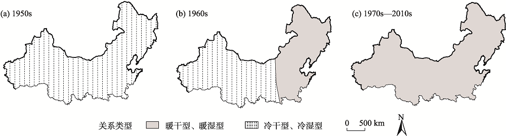
降水与气温间关系变化对水资源、植被、农业生产等方面影响较大,但大范围、多种气候类型区的二者关系及其时空变异性的成果仍较缺乏。利用中国北方及其周边357个气象站点1951—2018年降水量、气温月数据,定性、定量揭示了中国北方地区季节降水与气温间的关系及其时空变异性。结果表明:夏季降水与气温的相关性最强,秋季、冬季次之,春季最弱;各季节降水与平均气温、平均最高气温均以负相关为主,而与平均最低气温则以正相关居多。二者关系主要有暖干型、暖湿型、冷干型和冷湿型4类。降水与气温在1950s以冷干、冷湿型关系为主,自1960s开始,冷干、冷湿型关系的覆盖范围逐渐向西缩小,暖干、暖湿开始成为东北、华北等地区降水与气温的主要关系类型,进入1970s以后,研究区整体以暖干、暖湿型关系居多,并持续至今,但东北、华北等小范围地区在21世纪以后再次出现冷干、冷湿型关系,其中冬季覆盖范围最大。本研究丰富了降水与气温间关系的研究成果,为区域生态环境改善、水资源问题应对等提供了参考。
陈阳,马龙,刘廷玺,黄星. 中国北方地区季节降水与气温关系及其时空变异性[J]. 干旱区地理, 2021, 44(6): 1545-1558.
CHEN Yang,MA Long,LIU Tingxi,HUANG Xing. Relationship between seasonal precipitation and temperature and its spatiotemporal variability in northern China[J]. Arid Land Geography, 2021, 44(6): 1545-1558.

图1
研究区及气象站点分布图 注:该图基于国家测绘地理信息局标准地图服务网站下载的审图号为GS(2016)2923号的标准地图制作。下同。"
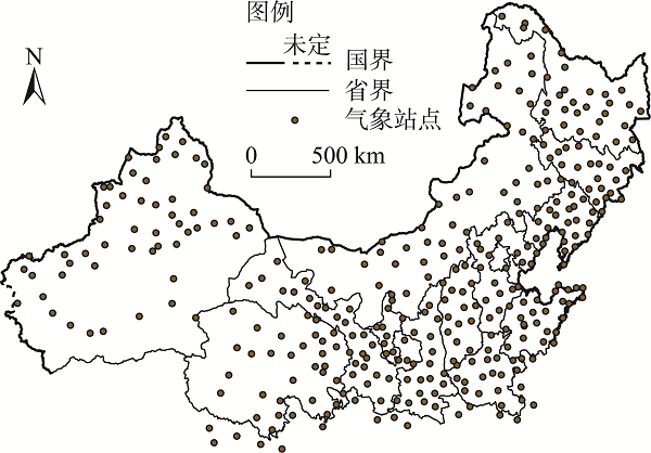
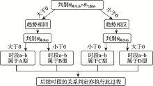
图2
降水与3类气温的关系判别流程 注:θ降水ab、θ气温ab分别为降水与气温在a~b时段的气候倾向率;a、b为含于1951—2018年内部的时间节点;A~D为降水与气温的关系类型代号。"

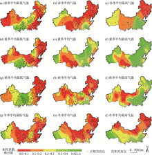
图3
各季节降水与3类气温相关系数的空间分布"
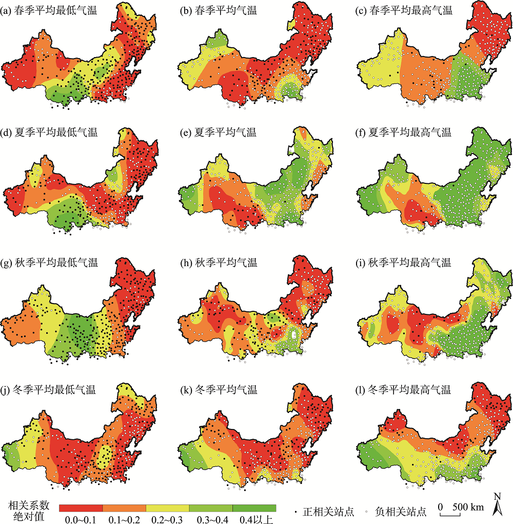
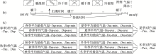
图4
降水与气温关系类型判定及其出现与持续时间命名方式 注:(a)降水与气温关系类型界定图,(b)各类关系出现时间、持续时间统计方法界定图,(c)各季节降水与3类气温间各类关系出现时间、持续时间缩写词命名图。"
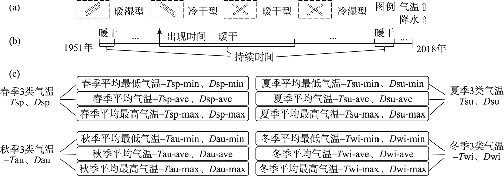
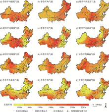
图5
暖干型关系出现时间、持续时间的空间分布 注:图中数字表示持续时间;箭头代表其由短至长的变化方向。下同。"


图6
暖湿型关系出现时间、持续时间空间分布"


图7
冷干型关系出现时间、持续时间空间分布"
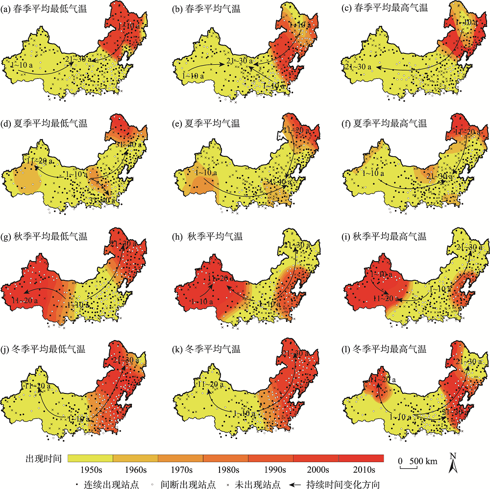
图8
冷湿型关系出现时间、持续时间空间分布"


图9
年代际季节降水与气温关系的时空演变"
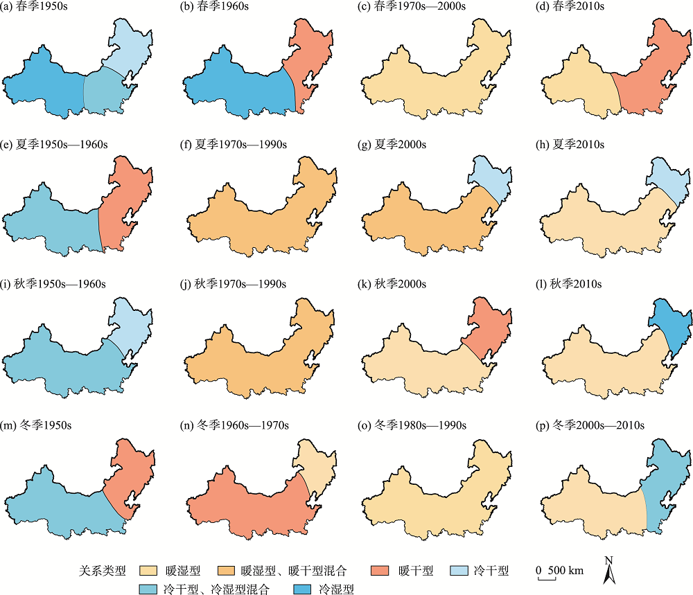
图10
降水与气温相关系数正负情况统计"
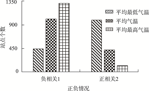
图11
年代际降水与气温关系的时空变异性"
| [1] |
Ngamindra D, Babu S U, Anita T. Temporal changes in precipitation and temperature and their implications on the streamflow of Rosi River, Central Nepal[J]. Climate, 2019, 7(1):3, doi: 10.3390/cli7010003.
doi: 10.3390/cli7010003 |
| [2] |
Zain N, Li X, Chen Y Y, et al. Temporal and spatial characteristics of precipitation and temperature in Punjab, Pakistan[J]. Water, 2019, 11(9):1916-1938.
doi: 10.3390/w11091916 |
| [3] | 许洁, 陈惠玲, 商沙沙, 等. 2000—2014年青藏高原植被净初级生产力时空变化及对气候变化的响应[J]. 干旱区地理, 2020, 43(3):592-601. |
| [ Xu Jie, Chen Huiling, Shang Shasha, et al. Response of net primary productivity of Tibetan Plateau vegetation to climate change based on CEVSA model[J]. Arid Land Geograghy, 2020, 43(3):592-601. ] | |
| [4] | 赵鸿雁, 陈英, 周翼, 等. 甘肃中东部增长生长季NDVI时空变化及其对气候因子的响应[J]. 干旱区地理, 2019, 42(6):1427-1435. |
| [ Zhao Hongyan, Chen Ying, Zhou Yi, et al. Spatiotemporal variation of NDVI invegetation growing season and its responses to climatic factors in mid and eastern Gansu Province from 2008 to 2016[J]. Arid Land Geograghy, 2019, 42(6):1427-1435. ] | |
| [5] | 张斯琦, 陈辉, 宋明华, 等. 柴达木盆地2000—2015年植被覆盖度的时空变化及其与环境因子的关系[J]. 干旱区地理, 2019, 42(5):1124-1132. |
| [ Zhang Siqi, Chen Hui, Song Minghua, et al. Spatial and temporal variation of fractional vegetation cover and its relationship with environmental factors in the Qaidam Basin during 2000—2015[J]. Arid Land Geograghy, 2019, 42(5):1124-1132. ] | |
| [6] |
Karimi V, Karimi E, Keshavarz M. Climate change and agriculture: Impacts and adaptive responses in Iran[J]. Journal of Integrative Agriculture, 2018, 17(1):1-15.
doi: 10.1016/S2095-3119(17)61794-5 |
| [7] |
Liang X Z, Wu Y, Chambers R G, et al. Determining climate effects on US total agricultural productivity[J]. Proceedings of the National Academy of Sciences of the United States of America, 2017, 114(12):E2285, doi: 10.1073/pnas.1615922114.
doi: 10.1073/pnas.1615922114 |
| [8] |
Sun Q H, Kong D X, Miao C Y, et al. Variations in global temperature and precipitation for the period of 1948 to 2010[J]. Environmental Monitoring and Assessment, 2014, 186(9):5663-5679.
doi: 10.1007/s10661-014-3811-9 |
| [9] | Schultz P A, Halpert M S. Global correlation of temperature, NDVI and precipitation[J]. Advances in Space Research, 1993, 13(5):277-280. |
| [10] |
Gornall J, Betts R, Burke E. Implications of climate change for agricultural productivity in the early twenty-first century[J]. Philosophical Transactions: Biological Sciences, 2010, 365(1554):2973-2989.
doi: 10.1098/rstb.2010.0158 |
| [11] | Beniston M, Richard S J T. The potential impacts of climate change on Europe[J]. Energy & Environment, 1998, 9(4):365-381. |
| [12] |
Erol A, Randhir T O. Climatic change impacts on the ecohydrology of Mediterranean watersheds[J]. Climatic Change, 2012, 114(2):319-341.
doi: 10.1007/s10584-012-0406-8 |
| [13] |
Pratik P, Ajay K, Sajjad A. Temperature and precipitation changes in the midwestern United States: Implications for water management[J]. International Journal of Water Resources Development, 2017, 33(6):1003-1019.
doi: 10.1080/07900627.2016.1238343 |
| [14] |
Dai S W, Shulski M D, Hubbard K G, et al. A spatiotemporal analysis of midwest US temperature and precipitation trends during the growing season from 1980 to 2013[J]. International Journal of Climatology, 2016, 36(1):517-525.
doi: 10.1002/joc.4354 |
| [15] |
Yadav S, Bhattacharya P, Srivastava K. Analysing long term seasonal and annual trends for precipitation and temperature in Central India (Article)[J]. Mausam, 2019, 70(3):523-532.
doi: 10.54302/mausam.v70i3 |
| [16] |
Dinesh B, Shreedhar M, Mukand B, et al. Climate trends and impacts on crop production in the Koshi River Basin of Nepal[J]. Regional Environmental Change, 2014, 14(4):1291-1301.
doi: 10.1007/s10113-013-0576-6 |
| [17] | 张国斌, 张勃, 王东, 等. 近14年西南地区植被季节变化及与气候关系[J]. 遥感信息, 2016, 31(1):89-95. |
| [ Zhang Guobin, Zhang Bo, Wang Dong, et al. Seasonal changes of vegetation in southwestern China and its relation to climate factors in recent 14 years[J]. Remote Sensing Information, 2016, 31(1):89-95. ] | |
| [18] |
Huang J Q, Ma J R, Guan X D, et al. Progress in semi-arid climate change studies in China[J]. Advances in Atmospheric Sciences, 2019, 36(9):922-937.
doi: 10.1007/s00376-018-8200-9 |
| [19] | 宋伟宏, 王莉娜, 张金龙. 甘肃祁连山自然保护区草地时空变化及其对气候的响应[J]. 草业科学, 2019, 36(9):2233-2249. |
| [ Song Weihong, Wang Lina, Zhang Jinlong. Temporal and spatial changes in response to climate in grasslands of the Qilian Mountain National Nature Reserve[J]. Pratacultural Science, 2019, 36(9):2233-2249. ] | |
| [20] | 王珂, 蒲焘, 史晓宜, 等. 澜沧江源区气温与降水对径流变化的影响[J]. 气候变化研究进展, 2020, 16(3):306-315. |
| [ Wang Ke, Pu Tao, Shi Xiaoyi, et al. Impact of temperature and precipitation on runoff change in the source region of Lancang River[J]. Climate Change Research, 2020, 16(3):306-315. ] | |
| [21] | 章大全, 张璐, 杨杰, 等. 近50年中国降水及温度变化在干旱形成中的影响[J]. 物理学报, 2010, 59(1):655-663. |
| [ Zhang Daquan, Zhang Lu, Yang Jie, et al. The impact of temperature and precipitation variation on drought in China in last 50 years[J]. Acta Physica Sinica, 2010, 59(1):655-663. ] | |
| [22] |
Shi Y F, Shen Y P, Kang E, et al. Recent and future climate change in northwest China[J]. Climate Change, 2007, 80(3-4):379-393.
doi: 10.1007/s10584-006-9121-7 |
| [23] | Cao D, Zhang J H, Yan H, et al. Regional assessment of climate potential productivity of terrestrial ecosystems and its responses to climate change over China from 1980—2018[J]. IEEE Access, 2020(8):11138-11151. |
| [24] | 施晓晖, 徐祥德. 1951—2002年全球陆地气温和降水的年代际趋势转折特征[J]. 自然科学进展, 2008, 18(9):1016-1026. |
| [ Shi Xiaohui, Xu Xiangde. The interdecadal trend turning feature of global land temperature and precipitation from 1951 to 2002[J]. Acta Physica Sinica, 2008, 18(9):1016-1026. ] | |
| [25] | 迪丽努尔·托列吾别克, 李栋梁. 近 115 a 中亚干湿气候变化研究[J]. 干旱气象, 2018, 36(2):185-195. |
| [ Tuoliewubieke Dilinuer, Li Dongliang. Characteristics of the dry/wet climate change in Central Asia in recent 115 years[J]. Journal of Arid Meteorology, 2018, 36(2):185-195. ] | |
| [26] |
Gong Z, Peng D L, Wen J Y, et al. Research on trend of warm-humid climate in Central Asia[J]. IOP Conference Series: Earth and Environmental Science, 2017, 74(1):012017, doi: 10.1088/1755-1315/74/1/012017.
doi: 10.1088/1755-1315/74/1/012017 |
| [27] |
Chris S H, Alistair J H, James R T, et al. Observed and predicted impacts of climate change on the estuaries of south-western Australia, a Mediterranean climate region[J]. Regional Environmental Change, 2018, 18(5):1357-1373.
doi: 10.1007/s10113-017-1264-8 |
| [28] |
Yang M X, Yao T D, Wang H J, et al. Correlation between precipitation and temperature variations in the past 300 years recorded in Guliya ice core, China[J]. Annals of Glaciology, 2006, 43:137-141.
doi: 10.3189/172756406781812384 |
| [29] | 苏明峰. 中国近半个世纪气候冷暖与干湿配置关系的研究[D]. 北京: 中国科学院大学, 2005. |
| [ Su Mingfeng. The configurable relationships between warm-cold and dry-wet in cliamte change over China[D]. Beijing: University of Chinese Academy of Sciences, 2005. ] | |
| [30] | 李虹雨, 马龙, 刘廷玺, 等. 1951—2014年内蒙古地区气温、降水变化及其关系[J]. 冰川冻土, 2017, 39(5):1098-1112. |
| [ Li Hongyu, Ma Long, Liu Tingxi, et al. Change and relationship of temperature and precipitation in Inner Mongolia during 1951—2014[J]. Journal of Glaciology and Geocryology, 2017, 39(5):1098-1112. ] | |
| [31] | 王静茹, 马龙, 刘廷玺, 等. 1951—2012 年科尔沁沙地气温、降水变化特征[J]. 干旱区研究, 2016, 33(1):49-58. |
| [ Wang Jingru, Ma Long, Liu Tingxi, et al. Variation of temperature and precipitation in Horqin Sandy Land from 1951 to 2012[J]. Arid Zone Research, 2016, 33(1):49-58. ] | |
| [32] | 黄星, 马龙, 刘廷玺, 等. 黄河流域内蒙古段1951—2012年气温降水变化及其关系[J]. 自然资源学报, 2016, 31(6):1027-1040. |
| [ Huang Xing, Ma Long, Liu Tingxi, et al. Variations and periodic symmetry of temperature and precipitation in Inner Mongolia section of the Yellow River Basin during 1951—2012[J]. Journal of Natural Resources, 2016, 31(6):1027-1040. ] | |
| [33] |
Shi P J, Sun S, Wang M, et al. Climate change regionalization in China (1961—2010)[J]. Science China: Earth Sciences, 2014, 57(11):2676-2689.
doi: 10.1007/s11430-014-4889-1 |
| [34] |
Samuel S, Olaf W, Alexander W, et al. Six temperature and precipitation regimes of the contiguous United States between 1895 and 2010: A statistical inference study[J]. Theoretical and Applied Climatology, 2016, 125(1-2):197-211.
doi: 10.1007/s00704-015-1502-2 |
| [35] |
Mifta U S, Rehana R, Percez A, et al. Temperature and precipitation trends in Kashmir Valley, north western Himalayas[J]. Theoretical and Applied Climatology, 2019, 135(1-2):293-304.
doi: 10.1007/s00704-018-2377-9 |
| [36] | 梁珑腾, 马龙, 刘廷玺, 等. 1951—2014年中国北方地区气温突变与变暖停滞的时空变异性[J]. 中国环境科学, 2018, 38(51):1601-1615. |
| [ Liang Longteng, Ma Long, Liu Tingxi, et al. Spatiotemporal variation of the temperature mutation and warming hiatus over northern China during 1951—2014[J]. China Environmental Science, 2018, 38(51):1601-1615. ] | |
| [37] | 陈阳, 马龙, 刘廷玺, 等. 中国北方地区年降水与气温关系及其时空变异性[J]. 生态环境学报, 2021, 30(1):135-145. |
| [ Chen Yang, Ma Long, Liu Tingxi, et al. The relationship between annual precipitation and temperature and its spatiotemporal variability in northern China[J]. Ecology and Environment, 2021, 30(1):135-145. ] | |
| [38] |
Kim J U, Boo K O, Shim S, et al. The seasonal correlation between temperature and precipitation over Korea and Europe and the future change from RCP8.5 scenario[J]. Atmosphere, 2017, 27(1):79-91.
doi: 10.14191/Atmos.2017.27.1.079 |
| [39] |
Tout D G. Short communication precipitation-temperature relationships in England and Wales summers[J]. Journal of Climatology, 1987, 7(2):181-184.
doi: 10.1002/joc.v7:2 |
| [40] |
Zhao W, Khalil M A K. The relationship between precipitation and temperature over the contiguous United States[J]. Journal of Climate, 1993, 6(6):1232-1236.
doi: 10.1175/1520-0442(1993)006<1232:TRBPAT>2.0.CO;2 |
| [41] |
Yukari T, Yasoichi E, Shigeki M. High correlation between winter precipitation and air temperature in heavy-snowfall areas in Japan[J]. Annals of Glaciology, 2008, 49(1):7-10.
doi: 10.3189/172756408787814898 |
| [42] | 施雅风, 沈永平, 李栋梁, 等. 中国西北气候由暖干向暖湿转型的特征和趋势探讨[J]. 第四纪研究, 2003, 23(2):152-164. |
| [ Shi Yafeng, Shen Yongping, Li Dongliang, et al. Discussion on the present climate change from warm-dry to warm-wet in northwest China[J]. Quaternary Sciences, 2003, 23(2):152-164. ] | |
| [43] | 施雅风, 沈永平, 胡汝骥. 西北气候由暖干向暖湿转型的信号、影响和前景初步探讨[J]. 冰川冻土, 2002, 24(3):219-226. |
| [ Shi Yafeng, Shen Yongping, Hu Ruji. Preliminary study on signal, impact and foreground of climatic shift from warm-dry to warm-humid in northwest China[J]. Journal of Glaciology and Geocryology, 2002, 24(3):219-226. ] | |
| [44] |
Li C, Wu P T, Li X L, et al. Spatial and temporal evolution of climatic factors and its impacts on potential evapotranspiration in Loess Plateau of northern Shaanxi, China[J]. Science of the Total Environment, 2017, 589:165-172.
doi: 10.1016/j.scitotenv.2017.02.122 |
| [45] |
He M X, Gautam M. Variability and trends in precipitation, temperature and drought indices in the state of California[J]. Hydrology, 2016, 3(2):14, doi: 10.3390/hydrology3020014.
doi: 10.3390/hydrology3020014 |
| [46] |
Du Q Q, Zhang M J, Wang S J, et al. Changes in air temperature over China in response to the recent global warming hiatus[J]. Journal of Geographical Sciences, 2019, 29(4):496-516.
doi: 10.1007/s11442-019-1612-3 |
| [47] |
Yao S L, Huang G, Wu R G, et al. The global warming hiatus: A natural product of interactions of a secular warming trend and a multi-decadal oscillation[J]. Theoretical and Applied Climatology, 2016, 123(1-2):349-360.
doi: 10.1007/s00704-014-1358-x |
| [48] | 苏京志, 温敏, 丁一汇, 等. 全球变暖趋缓研究进展[J]. 大气科学, 2016, 40(6):1143-1153. |
| [ Su Jingzhi, Wen Min, Ding Yihui, et al. Hiatus of global warming: A review[J]. Chinese Journal of Atmospheric Sciences, 2016, 40(6):1143-1153. ] | |
| [49] |
Shine K P, Forster P M de F. The effect of human activity on radiative forcing of climate change: A review of recent developments[J]. Global and Planetary Change, 1999, 20(4):205-225.
doi: 10.1016/S0921-8181(99)00017-X |
| [50] |
Zhang Q, Han L Y, Jia J Y, et al. Management of drought risk under global warming[J]. Theoretical and Applied Climatology, 2016, 125(1-2):187-196.
doi: 10.1007/s00704-015-1503-1 |
| [51] |
Huang J P, Yu H, Guan X, et al. Accelerated dryland expansion under climate change[J]. Nature Climate Change, 2016, 6(2):166-171.
doi: 10.1038/nclimate2837 |
| [1] | 刘文丽, 陈樟, 赵勇, 梁雨欣. 中亚5月土壤湿度异常对6月降水的影响[J]. 干旱区地理, 2024, 47(1): 38-47. |
| [2] | 史维良, 车璐阳, 李涛. 陕西省汛期极端降水概率分布及综合危险性评估[J]. 干旱区地理, 2023, 46(9): 1407-1417. |
| [3] | 牛怡莹, 李春兰, 王军, 许瀚卿, 刘青. 内蒙古ERA5再分析降水数据性能评估与极端降水时空特征分析[J]. 干旱区地理, 2023, 46(9): 1418-1431. |
| [4] | 张港栋, 包刚, 黄晓君, 元志辉, 温都日娜. 蒙古国冬春季气候非对称变暖及其对植被返青期和春季NDVI的影响[J]. 干旱区地理, 2023, 46(8): 1238-1249. |
| [5] | 黄鑫, 焦黎, 马晓飞, 王勇辉, 阿尔曼·阿布拉. 基于RClimDex模型的近60 a中亚极端降水事件变化特征[J]. 干旱区地理, 2023, 46(7): 1039-1051. |
| [6] | 柏荷, 明義森, 刘启航, 黄昌. 基于MGWR模型的黄河流域GPM卫星降水数据降尺度研究[J]. 干旱区地理, 2023, 46(7): 1052-1062. |
| [7] | 成硕, 李艳忠, 星寅聪, 于志国, 王渊刚, 黄曼捷. 遥感降水产品对黄河源区水文干旱特征的模拟性能分析[J]. 干旱区地理, 2023, 46(7): 1063-1072. |
| [8] | 陈跃萍, 武胜利, 赵昕, 张艺加. 近60 a哈密市极端气温时空变化特征[J]. 干旱区地理, 2023, 46(6): 868-879. |
| [9] | 仇会民, 万瑜, 张仕明, 肖莲媛, 周雪英, 温春, 蒋聚金. 新疆巴州北部冬半年降水相态气象因子特征和判识指标分析[J]. 干旱区地理, 2023, 46(4): 563-573. |
| [10] | 李娜,武永利,赵桂香,钱锦霞,李芬,赵海英,韩普. 近60 a山西省极端气温事件的年际变化及其对区域增暖的响应[J]. 干旱区地理, 2023, 46(3): 337-348. |
| [11] | 许昕彤,朱丽,吕潇雨,郭浩. MSWEP降水产品在黄河流域气象干旱监测中的适用性评价[J]. 干旱区地理, 2023, 46(3): 371-384. |
| [12] | 古力米热·哈那提, 姜波, 苏里坦, 张音, 胡可可. 基于气温变化的简易融雪模型研究[J]. 干旱区地理, 2023, 46(2): 169-177. |
| [13] | 曹玉娟, 司文洋, 杜自强, 梁寒雪, 雷添杰, 孙斌, 武志涛. 1982—2017年典型干旱年的中国GPP变化[J]. 干旱区地理, 2023, 46(10): 1577-1590. |
| [14] | 杨涛, 杨莲梅, 李建刚, 仝泽鹏. 中国天山西部区域云降水物理野外观测科学试验研究若干进展[J]. 干旱区地理, 2023, 46(10): 1602-1611. |
| [15] | 曹彦超,焦美玲,秦拓,郭桐. 1973—2020年甘肃河东夏半年降水变化特征及影响因素分析[J]. 干旱区地理, 2022, 45(6): 1695-1706. |
| Viewed | ||||||||||||||||||||||||||||||||||||||||||||||||||
|
Full text 261
|
|
|||||||||||||||||||||||||||||||||||||||||||||||||
|
Abstract 638
|
|
|||||||||||||||||||||||||||||||||||||||||||||||||
Cited |
|
|||||||||||||||||||||||||||||||||||||||||||||||||
| Shared | ||||||||||||||||||||||||||||||||||||||||||||||||||
|
||