干旱区地理 ›› 2026, Vol. 49 ›› Issue (8): 1587-1600.doi: 10.12118/j.issn.1000-6060.2025.508 cstr: 32274.14.ALG2025508
聂承静1,2( ), 李雅迪1, 刘方田1, 韩芳1, 高星1()
收稿日期:2025-07-27
修回日期:2025-09-23
出版日期:2026-08-25
发布日期:2026-08-21
通讯作者:
高星(1985-),男,博士,副教授,主要从事土地资源利用与评价等方面的研究. E-mail: gaoxing@hueb.edu.cn作者简介:聂承静(1982-),女,博士,副教授,主要从事城镇化与生态环境等方面的研究. E-mail: niechengjing@hueb.edu.cn
基金资助:
NIE Chengjing1,2(), LI Yadi1, LIU Fangtian1, HAN Fang1, GAO Xing1()
Received:2025-07-27
Revised:2025-09-23
Published:2026-08-25
Online:2026-08-21
摘要:
生境质量与城镇化协调发展是可持续发展的重要议题,也是中国式现代化的必然要求。以2000—2020年长城沿线97个市(盟)为研究单元,运用InVEST模型、耦合协调模型和时空地理加权回归模型等方法,系统解析生境质量与城镇化耦合协调的时空特征及驱动机理。结果表明:(1) 2000—2020年长城沿线生境质量总体格局保持相对稳定,呈东高西低梯度空间分布。城镇化存在京津和郑州等城市群地区极化领跑,全域共同发展的空间格局。(2) 2000—2020年长城沿线生境质量与城镇化耦合协调度呈缓慢增长态势,但整体水平仍然不高,凸显城镇化扩张与生态供给不足的结构性矛盾,长城沿线部分区域的相对发展度从城镇化滞后生境质量型转变为同步型乃至超前型。(3) 生境质量与城镇化耦合协调呈东高西低的空间分异特征,“高高集聚、低低集聚”的区域不平衡结构显著,“中部塌陷”现象逐步缓解,系统演化存在路径依赖性。(4) 生境质量与城镇化耦合协调的驱动过程复杂,降水、经济发展、科技创新和交通密度是关键正向因素,各因子对耦合协调关系影响存在时空异质性,建议不同地区根据资源禀赋和发展阶段,建立动态评估预警,制定差异化的系统协调发展策略,助力长城沿线人与自然和谐共生。
聂承静, 李雅迪, 刘方田, 韩芳, 高星. 长城沿线生境质量与城镇化时空耦合协调及驱动因子研究[J]. 干旱区地理, 2026, 49(8): 1587-1600.
NIE Chengjing, LI Yadi, LIU Fangtian, HAN Fang, GAO Xing. Spatiotemporal coupling coordination and driving factors of habitat quality and urbanization along the Great Wall[J]. Arid Land Geography, 2026, 49(8): 1587-1600.
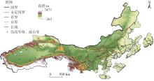
图1
研究区示意图 注:基于自然资源部标准地图服务网站审图号为GS(2024)0650号的标准地图制作,底图边界无修改。下同。"
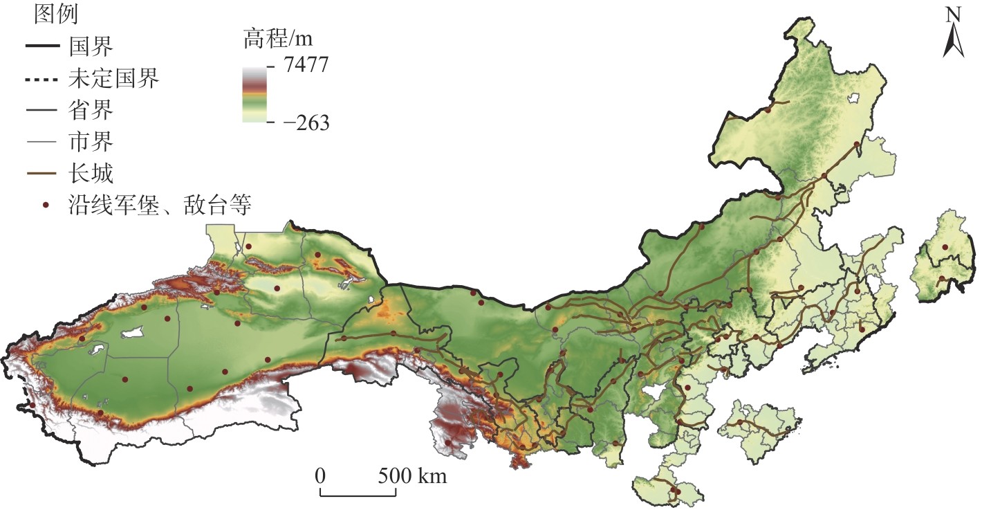

表1
城镇化指标体系"
| 目标层 | 准则层 | 指标层 | 权重 |
|---|---|---|---|
| 城镇化 | 人口城镇化 | 人口密度 | 0.2440 |
| 经济城镇化 | 地区生产总值密度 | 0.5049 | |
| 空间城镇化 | 城市建设用地占比 | 0.2511 |
表2
威胁因子及其胁迫强度"
| 威胁因子 | 最大胁迫距离/km | 影响权重 | 空间衰退类型 |
|---|---|---|---|
| 耕地 | 4 | 0.6 | 线性衰退 |
| 城镇用地 | 8 | 1.0 | 指数衰退 |
| 农村居民点 | 6 | 0.6 | 指数衰退 |
| 工业和交通用地 | 9 | 0.8 | 指数衰退 |
| 未利用地 | 4 | 0.5 | 线性衰退 |
表3
不同土地利用类型的生境适宜度及敏感性"
| 土地利 用类型 | 生境适 宜度 | 威胁因子 | ||||
|---|---|---|---|---|---|---|
| 耕地 | 城镇 用地 | 农村居 民点 | 工业和交 通用地 | 未利 用地 | ||
| 水田 | 0.3 | 0.0 | 0.8 | 0.5 | 0.6 | 0.3 |
| 旱地 | 0.5 | 0.0 | 0.8 | 0.5 | 0.7 | 0.4 |
| 有林地 | 1.0 | 0.6 | 0.9 | 0.8 | 0.8 | 0.4 |
| 灌木林 | 0.9 | 0.6 | 0.7 | 0.7 | 0.6 | 0.5 |
| 疏林地 | 0.8 | 0.7 | 0.9 | 0.8 | 0.8 | 0.5 |
| 其他林地 | 0.7 | 0.7 | 0.8 | 0.8 | 0.7 | 0.5 |
| 高覆盖度草地 | 0.9 | 0.6 | 0.7 | 0.6 | 0.6 | 0.7 |
| 中覆盖度草地 | 0.8 | 0.7 | 0.8 | 0.7 | 0.7 | 0.7 |
| 低覆盖度草地 | 0.7 | 0.7 | 0.8 | 0.8 | 0.7 | 0.7 |
| 河渠 | 0.9 | 0.6 | 0.7 | 0.7 | 0.8 | 0.4 |
| 湖泊 | 0.9 | 0.6 | 0.8 | 0.6 | 0.7 | 0.4 |
| 水库坑塘 | 0.8 | 0.5 | 0.8 | 0.7 | 0.7 | 0.4 |
| 永久性冰川雪地 | 0.1 | 0.1 | 0.0 | 0.1 | 0.2 | 0.1 |
| 滩涂 | 0.5 | 0.5 | 0.5 | 0.4 | 0.6 | 0.3 |
| 滩地 | 0.5 | 0.5 | 0.5 | 0.4 | 0.6 | 0.3 |
| 城镇用地 | 0.0 | 0.0 | 0.0 | 0.0 | 0.0 | 0.0 |
| 农村居民点 | 0.0 | 0.0 | 0.0 | 0.0 | 0.0 | 0.0 |
| 工业和交通用地 | 0.0 | 0.0 | 0.0 | 0.0 | 0.0 | 0.0 |
| 沙地 | 0.2 | 0.2 | 0.2 | 0.2 | 0.2 | 0.0 |
| 戈壁 | 0.1 | 0.1 | 0.1 | 0.1 | 0.1 | 0.0 |
| 盐碱地 | 0.2 | 0.2 | 0.2 | 0.2 | 0.3 | 0.0 |
| 沼泽地 | 0.2 | 0.2 | 0.3 | 0.3 | 0.3 | 0.0 |
| 裸土地 | 0.2 | 0.1 | 0.4 | 0.4 | 0.5 | 0.0 |
| 裸岩石质地 | 0.1 | 0.0 | 0.1 | 0.2 | 0.2 | 0.0 |
| 其他 | 0.1 | 0.1 | 0.1 | 0.1 | 0.1 | 0.0 |
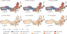
图2
2000—2020年长城沿线生境质量和城镇化的空间演变特征"
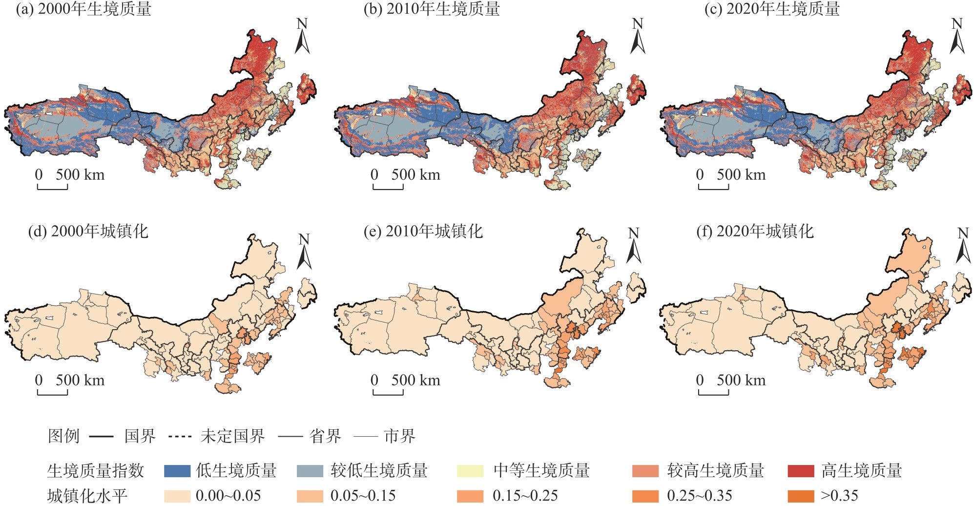
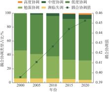
图3
2000—2020年长城沿线城镇化与生境质量耦合协调发展过程"
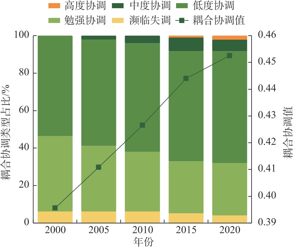
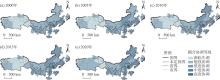
图4
2000—2020年长城沿线生境质量与城镇化耦合协调度空间演变过程"
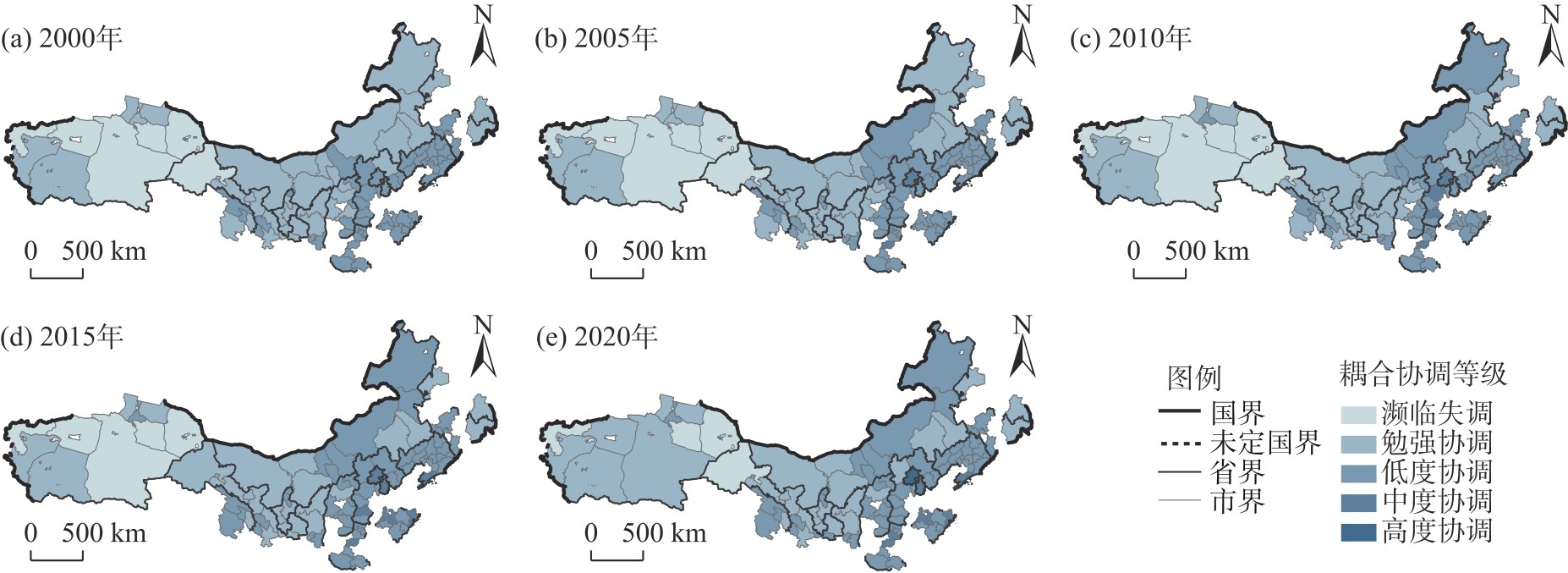
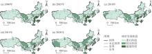
图5
2000—2020年长城沿线生境质量与城镇化相对发展度空间分布"
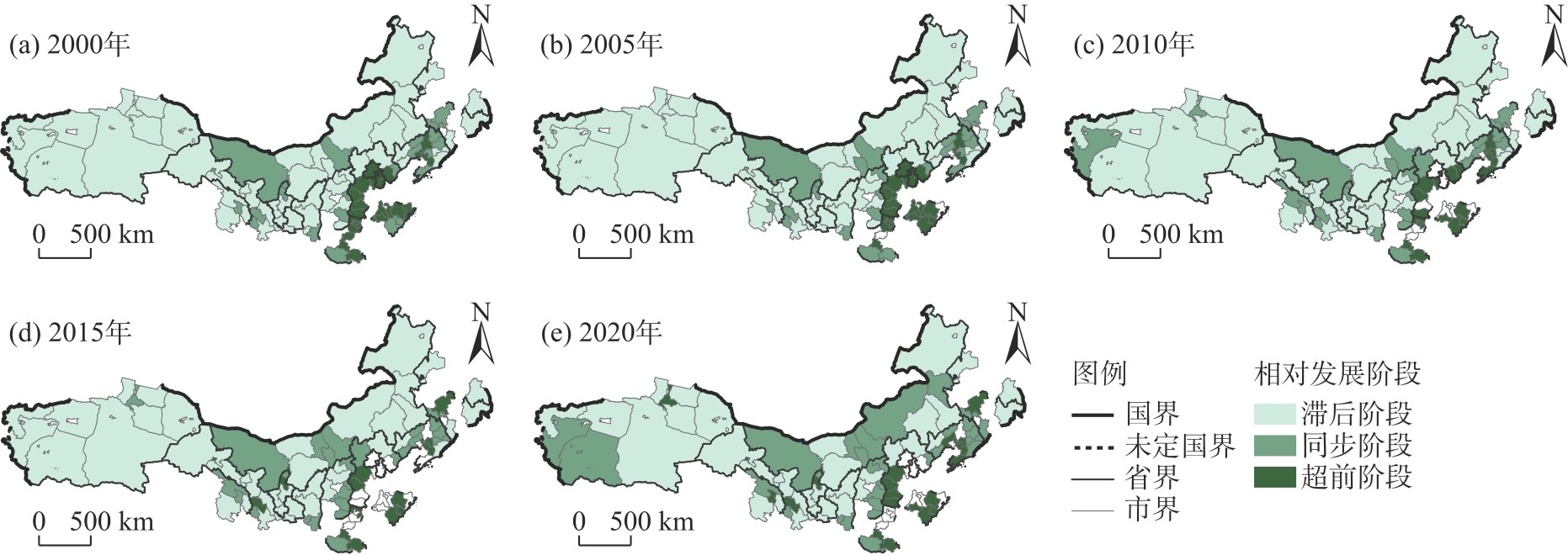
表4
空间半变异函数拟合参数"
| 年份 | 变程 | 块金值 | 基台值 | 块金系数 | 拟合模型 | 决定系数 | 残差 |
|---|---|---|---|---|---|---|---|
| 2000 | 3966 | 0.0232 | 0.2134 | 0.891 | 高斯模型 | 0.904 | 1.08×10⁻³ |
| 2005 | 4195 | 0.0200 | 0.1660 | 0.892 | 高斯模型 | 0.888 | 8.19×10⁻⁴ |
| 2010 | 3135 | 0.0200 | 0.1350 | 0.852 | 高斯模型 | 0.896 | 8.56×10⁻⁴ |
| 2015 | 7110 | 0.0181 | 0.1133 | 0.840 | 高斯模型 | 0.892 | 4.47×10⁻⁴ |
| 2020 | 7110 | 0.0105 | 0.0774 | 0.864 | 球状模型 | 0.864 | 3.19×10⁻⁴ |
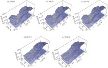
图6
2000—2020年空间变差函数克里金插值演化"

表5
全局莫兰指数"
| 年份 | 全局Moran’s I | Z统计量 | P值 |
|---|---|---|---|
| 2000 | 0.456 | 11.280 | 0.000 |
| 2005 | 0.480 | 11.798 | 0.000 |
| 2010 | 0.452 | 11.138 | 0.000 |
| 2015 | 0.422 | 10.414 | 0.000 |
| 2020 | 0.380 | 9.424 | 0.000 |
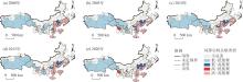
图7
2000—2020年耦合协调LISA集聚图"
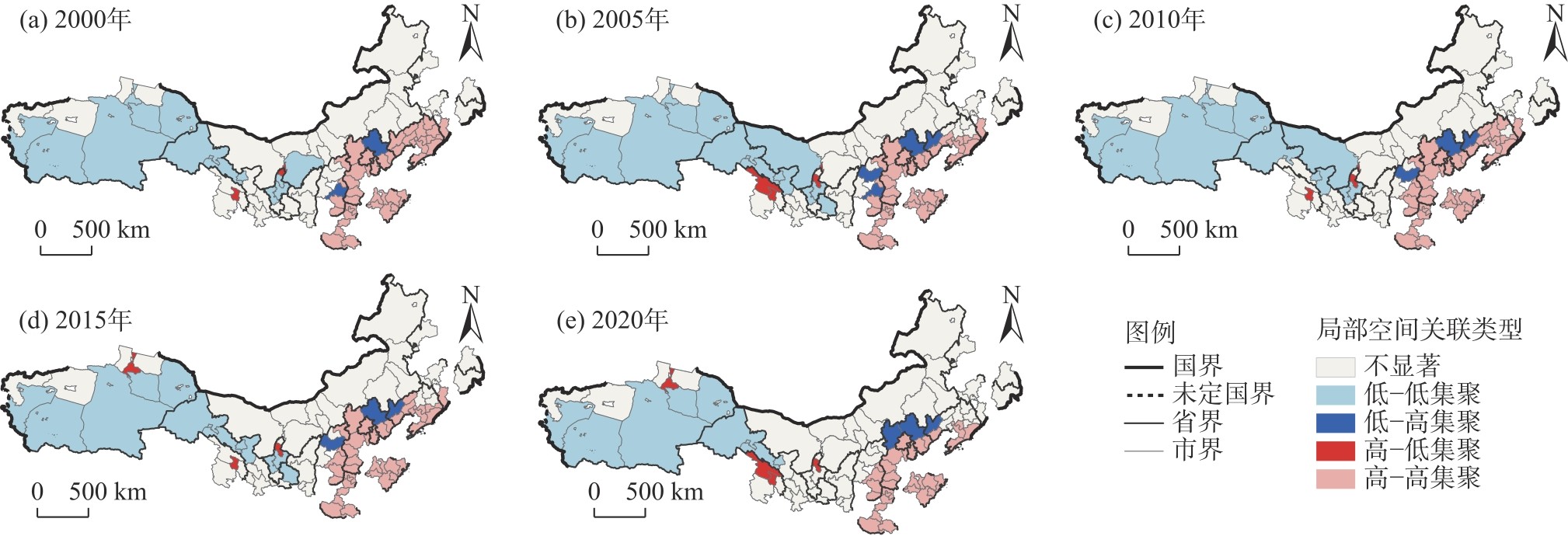
表6
SDM的回归结果"
| 变量 | 主效应 | 直接效应 | 间接效应 | 总效应 |
|---|---|---|---|---|
| 降水量 | 0.0158**(0.0072) | 0.0166**(0.0078) | -0.0203(0.0182) | -0.0037(0.0123) |
| 空气质量 | -0.0345*(0.0182) | -0.0364**(0.0184) | 0.1515***(0.0509) | 0.1151***(0.0401) |
| 经济发展 | 0.0064***(0.0007) | 0.0066***(0.0007) | -0.0089***(0.0022) | -0.0024(0.0020) |
| 产业结构 | 0.0084***(0.0026) | 0.0090***(0.0026) | -0.0241*(0.0143) | -0.0151(0.0141) |
| 科技创新 | 0.4914***(0.1362) | 0.5078***(0.1350) | -0.7723(0.5611) | -0.2645(0.5525) |
| 人力存量 | 0.0134***(0.0050) | 0.0133***(0.0051) | 0.0144(0.0209) | 0.0278(0.0196) |
| 交通密度 | -0.0126*(0.0069) | -0.0131*(0.0069) | 0.0219(0.0182) | 0.0088(0.0150) |
| 政府规制 | -0.0102*(0.0053) | -0.0096*(0.0056) | -0.0247(0.0250) | -0.0343(0.0251) |
| 空间自回归系数 | -0.8542***(0.3102) | - | - | - |
| 对数似然值 | 1307.4709 | - | - | - |
| 样本量 | 485 | - | - | - |
表7
模型选择与检验"
| 模型参数 | OLS | TWR | GWR | GTWR |
|---|---|---|---|---|
| 带宽 | - | 0.3284 | 0.2513 | 0.2209 |
| 残差平方和 | - | 2.0048 | 2.0251 | 1.7930 |
| 回归标准差 | - | 0.0643 | 0.0646 | 0.0608 |
| 赤池信息量准则 | -1214.45 | -1241.44 | -1230.25 | -1251.58 |
| R2 | 0.6800 | 0.7138 | 0.7109 | 0.7441 |
| 调整后R2 | - | 0.7090 | 0.7061 | 0.7398 |
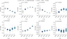
图8
2000—2020年长城沿线驱动因子回归系数的时间演化趋势 注:1.5IQR为1.5范围内的异常值。"

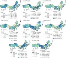
图9
2000—2020年长城沿线协调性驱动回归拟合系数空间分布"

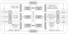
图10
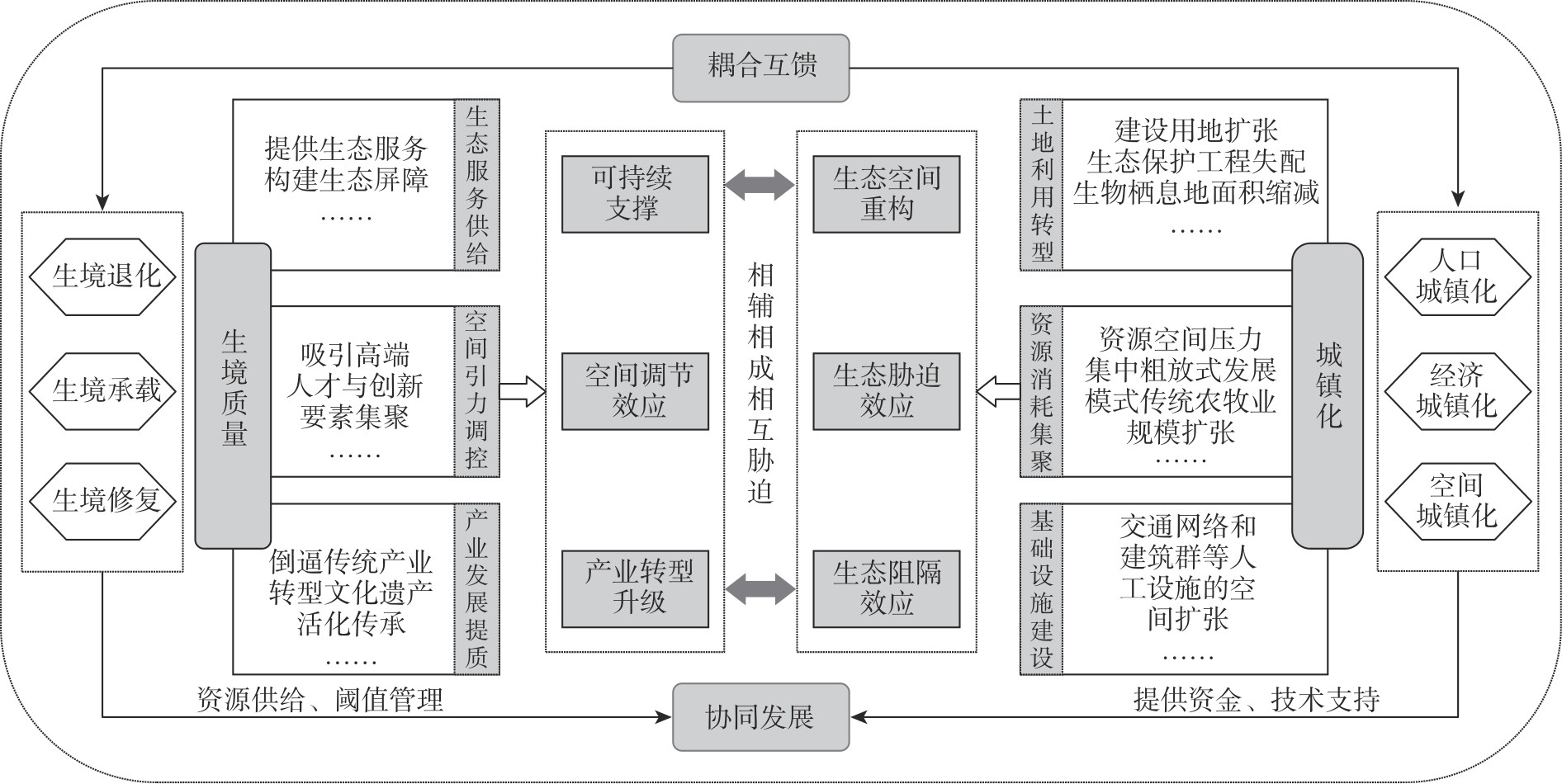
生境质量与城镇化耦合协调机理"
| [1] | Parvar Z, Salmanmahiny A. Assessing and predicting habitat quality under urbanization and climate pressures[J]. Journal for Nature Conservation, 2025, 86: 126903, doi: 10.1016/j.jnc.2025.126903. |
| [2] | Zeng X Y, Zhang H Q, Zhou B Q, et al. Hydrological dynamics and its impact on wetland ecological functions in the Sanjiang Plain, China[J]. Ecological Indicators, 2024, 169: 112878, doi: 10.1016/j.ecolind.2024.112878. |
| [3] |
张学儒, 周杰, 李梦梅. 基于土地利用格局重建的区域生境质量时空变化分析[J]. 地理学报, 2020, 75(1): 160-178.
doi: 10.11821/dlxb202001012 |
|
[Zhang Xueru, Zhou Jie, Li Mengmei. Analysis on spatial and temporal changes of regional habitat quality based on the spatial pattern reconstruction of land use[J]. Acta Geographica Sinica, 2020, 75(1): 160-178.]
doi: 10.11821/dlxb202001012 |
|
| [4] | Zhang S H, Jiang H L, Yu H L, et al. Construction of landscape ecological network based on MCR risk assessment model: A case study of Liaoning Province, China[J]. Ecological Indicators, 2024, 166: 112549, doi: 10.1016/j.ecolind.2024.112549. |
| [5] | Quadroni S, Cesarini G, Santis D V, et al. Interconnected impacts of water resource management and climate change on microplastic pollution and riverine biocoenosis: A review by freshwater ecologists[J]. Journal of Environmental Management, 2024, 372: 123363, doi: 10.1016/j.jenvman.2024.123363. |
| [6] |
孙杰, 余明成, 甄峰, 等. 新型城镇化与乡村振兴协调发展评估——浙江省案例[J]. 经济地理, 2023, 43(2): 115-123.
doi: 10.15957/j.cnki.jjdl.2023.02.012 |
| [Sun Jie, Yu Mingcheng, Zhen Feng, et al. Evaluation of the performance of coordinated development between new-type urbanization and rural revitalization: A case study of Zhejiang Province[J]. Economic Geography, 2023, 43(2): 115-123.] | |
| [7] | Almulhim A I, Cobbinah P B. Can rapid urbanization be sustainable? The case of Saudi Arabian cities[J]. Habitat International, 2023, 139: 102884, doi: 10.1016/j.habitatint.2023.102884. |
| [8] | 徐梦佳, 孙杰, 顾羊羊, 等. 长三角城市群城镇扩张对生态系统服务的影响研究[J]. 环境污染与防治, 2025, 47(8): 131-137. |
| [Xu Mengjia, Sun Jie, Gu Yangyang, et al. Research on the impact of urban expansion on ecosystem services in the Yangtze River Delta urban agglomeration[J]. Environmental Pollution & Control, 2025, 47(8): 131-137.] | |
| [9] |
罗耀, 方世明, 徐枫. 人口收缩背景下东北三省城镇化与生境质量协调发展研究——基于增长城市与收缩城市的对比[J]. 地理科学, 2025, 45(11): 2468-2480.
doi: 10.13249/j.cnki.sgs.20240197 |
| [Luo Yao, Fang Shiming, Xu Feng. Coordinated development of urbanization and habitat quality between growing and shrinking cities in context of population shrinkage: Evidence from three provinces of northeast China[J]. Geographical Science, 2025, 45(11): 2468-2480.] | |
| [10] | 陈海燕, 董耀会, 向燕南, 等. 中国长城志[M]. 南京: 江苏凤凰科学技术出版社, 2016. |
| [Chen Haiyan, Dong Yaohui, Xiang Yannan, et al. Chronicles of the Great Wall of China[M]. Nanjing: Jiangsu Phoenix Science and Technology Press, 2016.] | |
| [11] |
张晓东, 武丹, 王莹, 等. 耦合InVEST与Geodetector模型的银川市生境质量时空演变特征及影响因子研究[J]. 干旱区地理, 2024, 47(7): 1242-1251.
doi: 10.12118/j.issn.1000-6060.2023.563 |
|
[Zhang Xiaodong, Wu Dan, Wang Ying, et al. Spatiotemporal evolution characteristics and influencing factors of habitat quality in Yinchuan City by coupling InVEST and Geodetector models[J]. Arid Land Geography, 2024, 47(7): 1242-1251.]
doi: 10.12118/j.issn.1000-6060.2023.563 |
|
| [12] | 梅承志, 李斌, 何友江, 等. 2015—2023年天山北坡区域PM2.5与O3-8 h变化趋势及影响因素分析[J]. 环境科学学报, 2025, 45(1):388-399. |
| [Mei Chengzhi, Li Bin, He Youjiang, et al. Variation trends and influencing factors of PM2.5 and O3-8 h on the north slope of Tianshan Mountain during 2015—2023[J]. Acta Scientiae Circumstantiae, 2025, 45(1): 388-399.] | |
| [13] | 苏军德, 赵晓冏, 李国霞, 等. 祁连山国家自然保护区生境质量时空特征及驱动因素分析[J]. 中国环境科学, 2024, 44(5): 2595-2605. |
| [Su Junde, Zhao Xiaojiong, Li Guoxia, et al. Spatial and temporal characteristics and driving factors of habitat quality in Qilian Mountain National Nature Reserve[J]. China Environment Science, 2024, 44(5): 2595-2605.] | |
| [14] |
宋永永, 薛东前, 马蓓蓓, 等. 黄土高原城镇化过程及其生态环境响应格局[J]. 经济地理, 2020, 40(6): 174-184.
doi: 10.15957/j.cnki.jjdl.2020.06.019 |
|
[Song Yongyong, Xue Dongqian, Ma Beibei, et al. Urbanization process and its ecological environment response pattern on the Loess Plateau, China[J]. Economic Geography, 2020, 40(6): 174-184.]
doi: 10.15957/j.cnki.jjdl.2020.06.019 |
|
| [15] |
刘海龙, 王改艳, 张鹏航, 等. 汾河流域新型城镇化与生态韧性耦合协调时空演变及协调影响力研究[J]. 自然资源学报, 2024, 39(3): 640-667.
doi: 10.31497/zrzyxb.20240309 |
|
[Liu Hailong, Wang Gaiyan, Zhang Penghang, et al. Spatio-temporal evolution and coordination influence of coupling coordination between new urbanization and ecological resilience in Fenhe River Basin[J]. Journal of Natural Resources, 2024, 39(3): 640-667.]
doi: 10.31497/zrzyxb.20240309 |
|
| [16] |
Goovaerts P. Geostatistical approaches for interpolating elevation into the spatial interpolation of rainfall[J]. Journal of Hydrology, 2000, 228(1): 113-129.
doi: 10.1016/S0022-1694(00)00144-X |
| [17] |
王兆峰, 谢佳亮. 中国旅游产业组织的时空耦合关系及影响因素[J]. 地理学报, 2023, 78(4): 961-979.
doi: 10.11821/dlxb202304012 |
|
[Wang Zhaofeng, Xie Jialiang. Spatiotemporal coupling relationship and influencing factors of China’s tourism industry organization[J]. Acta Geographica Sinica, 2023, 78(4): 961-979.]
doi: 10.11821/dlxb202304012 |
|
| [18] |
刘昊, 李福莲, 汪圣. 中国居家社区养老与机构养老耦合协调格局及影响因素研究[J]. 干旱区地理, 2026, 49(2): 381-392.
doi: 10.12118/j.issn.1000-6060.2025.310 |
| [Liu Hao, Li Fulian, Wang Sheng. Coupling and coordination pattern and influencing factors of home community elderly care and institutional elderly care in China[J]. Arid Land Geography, 2026, 49(2): 381-392.] | |
| [19] |
王兆峰, 张先甜. 中国人-地-粮复合系统适配性评价及影响[J]. 地理学报, 2024, 79(3): 779-799.
doi: 10.11821/dlxb202403014 |
|
[Wang Zhaofeng, Zhang Xiantian. Evaluation and impact of adaptability of China’s population-cultivated land-grain composite system[J]. Acta Geographica Sinica, 2024, 79(3): 779-799.]
doi: 10.11821/dlxb202403014 |
|
| [20] | 陈贵富, 韩静, 韩恺明. 城市数字经济发展、技能偏向型技术进步与劳动力不充分就业[J]. 中国工业经济, 2022(8): 118-136. |
| [Chen Guifu, Han Jing, Han Kaiming. Urban digital economy development, skill-biased technological change and underemployment[J]. China Industrial Economics, 2022(8): 118-136.] | |
| [21] | 陈慧敏, 赵宇, 付晓, 等. 西辽河上游生境质量时空演变特征与影响机制[J]. 生态学报, 2023, 43(3): 948-961. |
| [Chen Huimin, Zhao Yu, Fu Xiao, et al. Characteristics of spatio-temporal evolution and influence mechanism of habitat quality in the upper reaches of the west Liaohe River[J]. Acta Ecologica Sinica, 2023, 43(3): 948-961.] | |
| [22] |
郝帅, 孙才志, 翟小清. 中国水资源-能源-粮食系统效率时空格局及影响因素[J]. 地理学报, 2024, 79(9): 2389-2406.
doi: 10.11821/dlxb202409015 |
|
[Hao Shuai, Sun Caizhi, Zhai Xiaoqing. Spatio-temporal pattern and influencing factors of efficiency of water-energy-food system in China[J]. Acta Geographica Sinica, 2024, 79(9): 2389-2406.]
doi: 10.11821/dlxb202409015 |
|
| [23] |
赵林, 张春霆, 高晓彤, 等. 黄河流域绿色发展与共同富裕耦合协调水平变化及其影响因素[J]. 经济地理, 2024, 44(8): 57-67.
doi: 10.15957/j.cnki.jjdl.2024.08.008 |
|
[Zhao Lin, Zhang Chunting, Gao Xiaotong, et al. Spatiotemporal evolution and influencing factors of the coupling coordination level between green development and common prosperity in the Yellow River Basin[J]. Economic Geography, 2024, 44(8): 57-67.]
doi: 10.15957/j.cnki.jjdl.2024.08.008 |
|
| [24] |
崔丹, 李沅曦, 吴殿廷. 京津冀地区旅游经济增长的时空演化及影响因素[J]. 地理学报, 2022, 77(6): 1391-1410.
doi: 10.11821/dlxb202206007 |
|
[Cui Dan, Li Yuanxi, Wu Dianting. Spatiotemporal evolution and influencing factors of tourism economic growth in Beijing-Tianjin-Hebei region[J]. Acta Geographica Sinica, 2022, 77(6): 1391-1410.]
doi: 10.11821/dlxb202206007 |
|
| [25] | Chen S J, Lin J Y, Wu T L, et al. Assessing flood and waterlogging vulnerability and community governance in urban villages in the context of climate change: A case study of 89 urban villages in Shanghai[J]. Sustainable Cities and Society, 2025, 126: 106377, doi: 10.1016/j.scs.2025.106377. |
| [26] | Chen W X, Huang M. Improvement of transportation infrastructure, payment digitalization, and tourism consumption expenditure: Analysis based on CHFS data[J]. Finance Research Letters, 2025, 76: 107000, doi: 10.1016/j.frl.2025.107000. |
| [27] |
刘春芳, 王川, 刘立程. 三大自然区过渡带生境质量时空差异及形成机制——以榆中县为例[J]. 地理研究, 2018, 37(2): 419-432.
doi: 10.11821/dlyj201802014 |
| [Liu Chunfang, Wang Chuan, Liu Licheng. Spatio-temporal variation on habitat quality and its mechanism within the transitional area of the three natural zones: A case study in Yuzhong County[J]. Geographical Research, 2018, 37(2): 419-432.] | |
| [28] |
王超, 雷婷, 孟晓莎, 等. “交旅”融合下旅游经济与高速交通协调发展分析——以关中平原城市群为例[J]. 干旱区地理, 2024, 47(6): 1015-1025.
doi: 10.12118/j.issn.1000-6060.2023.332 |
| [Wang Chao, Lei Ting, Meng Xiaosha, et al. Analysis of the coordinated development of tourism economy and high-speed transportation under the integration of “transportation and tourism”: Based on Guanzhong Plain urban agglomeration[J]. Arid Land Geography, 2024, 47(6): 1015-1025.] | |
| [29] | Uzun B, Yıldırım V, Çoruhlu Y E, et al. The process of transition to a value-based distribution model in the Turkish land readjustment system[J]. Land Use Policy, 2024, 147: 107360, doi: 10.1016/j.landusepol.2024.107360. |
| [30] | Li F, Meng B, Wang Y B. Agricultural land system transition based on resilience and vitality: A case study on the Loess Plateau (Yulin, China)[J]. Journal of Rural Studies, 2025, 117: 103643, doi: 10.1016/j.jrurstud.2025.103643. |
| [1] | 仝雁军, 袁露, 雷军. 边疆安全背景下新疆边境人口-社会经济-资源环境耦合协调关系研究[J]. 干旱区地理, 2026, 49(8): 1626-1639. |
| [2] | 路知秋, 律名扬, 李智慧, 徐丽萍. “人-地-业”视角下新疆城乡融合发展的多维评价与时空演化[J]. 干旱区地理, 2026, 49(8): 1750-1763. |
| [3] | 宁雅萱, 尹豪, 李金诺. 中国北方农牧交错带中段新型城镇化与农业生态系统服务耦合分析[J]. 干旱区地理, 2026, 49(7): 1457-1469. |
| [4] | 李文君, 张维梅. 中国数字经济与共同富裕的耦合协调关系及时空演进趋势[J]. 干旱区地理, 2026, 49(7): 1481-1492. |
| [5] | 高莹, 周可丽, 元媛, 史薪茹, 吴佳霖. 黄河流域旅游经济与居民福祉耦合协调时空演变及驱动机制研究[J]. 干旱区地理, 2026, 49(7): 1493-1508. |
| [6] | 吕宛青, 宋志高, 肖钊富. 中国新型城镇化与旅游业高质量发展耦合协调、障碍诊断及驱动因素[J]. 干旱区地理, 2026, 49(5): 1063-1073. |
| [7] | 杨蓉欣, 原野, 袁媛, 杨雨青, 武艺超. 陕北黄土高原生态系统服务与人类福祉关系的尺度依赖性——基于生态恢复与社会发展双重驱动[J]. 干旱区地理, 2026, 49(5): 949-962. |
| [8] | 王伟军, 李娟, 李花. 黄河流域旅游-生态-福祉耦合协调的多尺度时空演化及分异机理[J]. 干旱区地理, 2026, 49(4): 683-696. |
| [9] | 王慧丽, 李妞, 刘英, 刘咏涵. 黄河流域水资源-生态韧性动态耦合与级层障碍解析[J]. 干旱区地理, 2026, 49(3): 569-580. |
| [10] | 高俊杰, 仲俊涛, 马勇洁, 陈颖慧. 青海湖国家公园农户现代化与生计稳定性耦合协调研究[J]. 干旱区地理, 2026, 49(3): 631-642. |
| [11] | 刘昊, 李福莲, 汪圣. 中国居家社区养老与机构养老耦合协调格局及影响因素研究[J]. 干旱区地理, 2026, 49(2): 381-392. |
| [12] | 欧开航, 方世巧, 程乾, 周徐帆. 农村公共服务与乡村旅游耦合协调度及其乡村振兴影响效应——基于西部地区的实证[J]. 干旱区地理, 2026, 49(2): 404-415. |
| [13] | 孙国军, 李家瑶, 王子轩. 黄河流域数文旅产业发展水平评价与耦合协调时空特征分析[J]. 干旱区地理, 2026, 49(1): 117-127. |
| [14] | 王雅俊, 王一峰. 宁夏易地扶贫搬迁安置区融入新型城镇化效果评价及影响因素[J]. 干旱区地理, 2026, 49(1): 186-197. |
| [15] | 徐建斌, 曹小曙. 宁夏小流域尺度水土资源耦合特征及影响因素[J]. 干旱区地理, 2025, 48(9): 1531-1540. |
|
||

