Arid Land Geography ›› 2024, Vol. 47 ›› Issue (2): 260-269.doi: 10.12118/j.issn.1000-6060.2023.066
• Ecology and Environment • Previous Articles Next Articles
HAN Chuqiao1( ), ZHENG Jianghua1,2(), WANG Zhe1, YU Wenjie1
Received:2023-02-17
Revised:2023-04-05
Online:2024-02-25
Published:2024-03-14
Contact:
ZHENG Jianghua
E-mail:hanchuqiao@stu.xju.edu.cn;zheng.jianghua@xju.edu.cn
HAN Chuqiao, ZHENG Jianghua, WANG Zhe, YU Wenjie. Spatiotemporal variation and multiscenario simulation of carbon storage in terrestrial ecosystems in the Turpan-Hami Basin based on PLUS-InVEST model[J].Arid Land Geography, 2024, 47(2): 260-269.
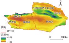
Fig. 1
Schematic diagram of the study area"

Tab. 1
Data types and sources"
| 数据 | 类型 | 分辨率 | 来源 | |
|---|---|---|---|---|
| 土地利用数据 | 栅格 | 30 m | 中国年度土地覆盖数据集( | |
| 地形数据 | DEM | 栅格 | 30 m | 地理空间数据云( |
| 坡度 | 栅格 | 30 m | 基于DEM数据得到 | |
| 气象数据 | 年平均气温 | 栅格 | 1 km | 资源环境科学与数据中心( 资源环境科学与数据中心( |
| 年平均降水量 | 栅格 | 1 km | ||
| 路网数据 | 与道路的距离 | 栅格 | 30 m | OpenStreetMap( |
| 社会经济数据 | GDP | 栅格 | 1 km | 资源环境科学与数据中心( 资源环境科学与数据中心( |
| 人口 | 栅格 | 1 km | ||
Tab. 2
Carbon density of different land cover types of carbon pools in the Turpan-Hami Basin /t·hm-2"
| 土地覆盖类型 | |||||
|---|---|---|---|---|---|
| 耕地 | 2.87 | 3.41 | 87.47 | 0.00 | 93.75 |
| 森林 | 30.58 | 9.03 | 123.11 | 0.00 | 162.71 |
| 灌木林 | 4.34 | 2.85 | 72.90 | 0.00 | 80.09 |
| 草地 | 0.48 | 4.24 | 86.25 | 0.00 | 90.98 |
| 水体 | 0.00 | 0.00 | 0.00 | 0.00 | 0.00 |
| 裸土地 | 0.45 | 0.44 | 15.55 | 0.00 | 16.44 |
| 建设用地 | 0.00 | 0.00 | 0.00 | 0.00 | 0.00 |
| 湿地 | 1.83 | 1.46 | 242.84 | 0.00 | 246.14 |
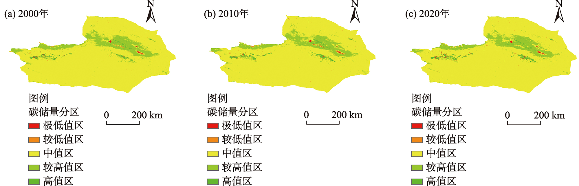
Fig. 2
Spatial distributions of land cover from 2000 to 2020"
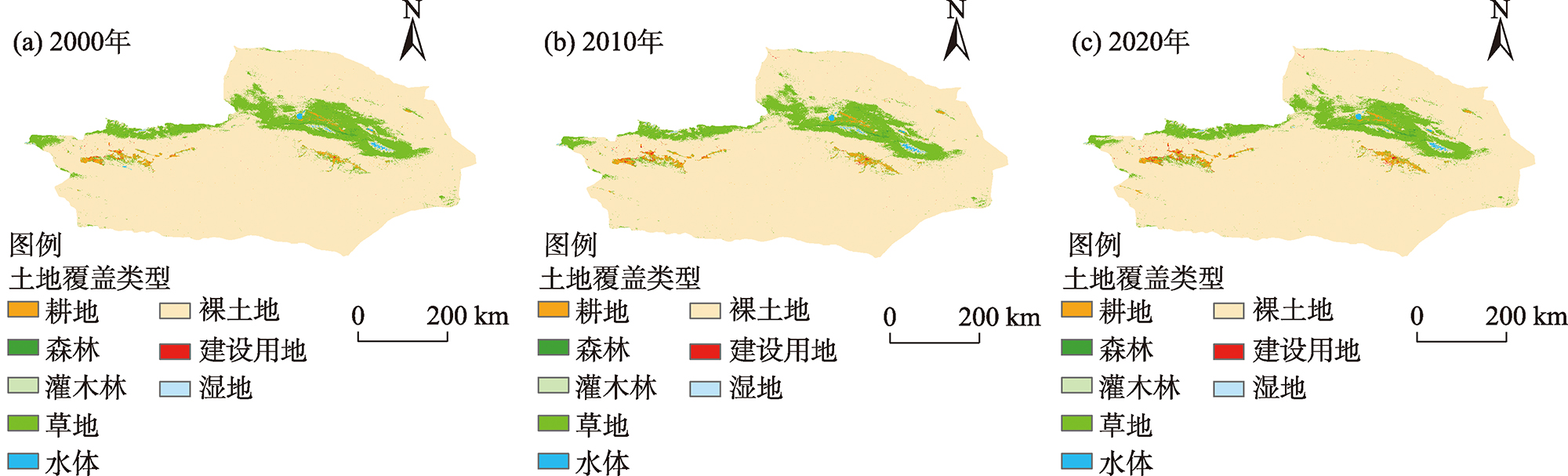
Fig. 3
Spatial distributions of carbon storage from 2000 to 2020"
Tab. 3
Carbon storage of different land cover types from 2000 to 2020 /106 t"
| 土地覆盖类型 | 2000年 | 2005年 | 2010年 | 2015年 | 2020年 |
|---|---|---|---|---|---|
| 耕地 | 17.7707 | 20.1326 | 22.4675 | 25.1001 | 23.7995 |
| 森林 | 5.8859 | 6.1228 | 6.3795 | 6.9071 | 7.1124 |
| 灌木林 | 0.0004 | 0.0003 | 0.0003 | 0.0003 | 0.0003 |
| 草地 | 222.0520 | 216.7252 | 208.6479 | 220.2085 | 207.8454 |
| 水体 | 0.0000 | 0.0000 | 0.0000 | 0.0000 | 0.0000 |
| 裸土地 | 300.4230 | 300.8483 | 301.6903 | 298.9310 | 301.5034 |
| 建设用地 | 0.0000 | 0.0000 | 0.0000 | 0.0000 | 0.0000 |
| 湿地 | 0.0054 | 0.0057 | 0.0055 | 0.0064 | 0.0068 |

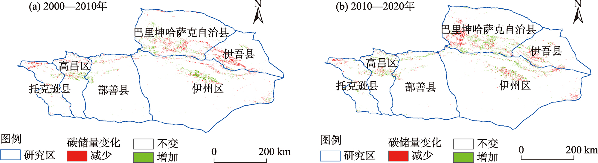
Fig. 4
Spatial changes of carbon storage from 2000 to 2020"
Tab. 4
Area of land cover types in the future under different scenarios /103 hm2"
| 土地覆盖类型 | 可持续发展情景 | 维持现状情景 | 经济优先发展情景 | |||||
|---|---|---|---|---|---|---|---|---|
| 2025年 | 2030年 | 2025年 | 2030年 | 2025年 | 2030年 | |||
| 耕地 | 253.948 | 230.648 | 261.920 | 272.906 | 233.382 | 224.268 | ||
| 森林 | 43.719 | 43.731 | 45.871 | 47.852 | 42.731 | 42.722 | ||
| 灌木林 | 0.004 | 0.004 | 0.004 | 0.003 | 0.004 | 0.004 | ||
| 草地 | 2284.593 | 2311.071 | 2273.929 | 2254.925 | 2304.613 | 2306.341 | ||
| 水体 | 39.761 | 39.761 | 39.750 | 38.381 | 39.744 | 39.726 | ||
| 裸土地 | 18332.667 | 18334.358 | 18332.667 | 18334.358 | 18332.667 | 18334.358 | ||
| 建设用地 | 45.281 | 40.398 | 45.831 | 51.545 | 46.835 | 52.575 | ||
| 湿地 | 0.028 | 0.028 | 0.028 | 0.030 | 0.028 | 0.028 | ||
Tab. 5
Carbon storage of different land cover types under different scenarios /106 t"
| 土地覆盖类型 | 可持续发展情景 | 维持现状发展情景 | 经济优先发展情景 | |||||
|---|---|---|---|---|---|---|---|---|
| 2025年 | 2030年 | 2025年 | 2030年 | 2025年 | 2030年 | |||
| 耕地 | 23.8065 | 21.6222 | 24.5539 | 25.5837 | 21.8785 | 21.0241 | ||
| 森林 | 7.1137 | 7.1156 | 7.4638 | 7.7862 | 6.9529 | 6.9515 | ||
| 灌木林 | 0.0003 | 0.0003 | 0.0003 | 0.0002 | 0.0003 | 0.0003 | ||
| 草地 | 207.8500 | 210.2589 | 206.8798 | 205.1508 | 209.6714 | 209.8286 | ||
| 水体 | 0.0000 | 0.0000 | 0.0000 | 0.0000 | 0.0000 | 0.0000 | ||
| 裸土地 | 301.4156 | 301.4434 | 301.4156 | 301.4434 | 301.4156 | 301.4434 | ||
| 建设用地 | 0.0000 | 0.0000 | 0.0000 | 0.0000 | 0.0000 | 0.0000 | ||
| 湿地 | 0.0069 | 0.0069 | 0.0069 | 0.0074 | 0.0069 | 0.0069 | ||
| 总计 | 540.1930 | 540.4474 | 540.3203 | 539.9718 | 539.9257 | 539.2548 | ||
| [1] |
Ito A, Nishina K, Noda H M. Impacts of future climate change on the carbon budget of northern high-latitude terrestrial ecosystems: An analysis using ISI-MIP data[J]. Polar Science, 2016, 10(3): 346-355.
doi: 10.1016/j.polar.2015.11.002 |
| [2] | Yue C, Ciais P, Houghton R A, et al. Contribution of land use to the interannual variability of the land carbon cycle[J]. Nature Communications, 2020, 11(1): 3170, doi: 10.1038/s41467-020-16953-8. |
| [3] | Winkler K, Fuchs R, Rounsevell M, et al. Global land use changes are four times greater than previously estimated[J]. Nature Communications, 2021, 12(1): 2501, doi: 10.1038/s41467-021-22702-2. |
| [4] |
付超, 于贵瑞, 方华军, 等. 中国区域土地利用/覆被变化对陆地碳收支的影响[J]. 地理科学进展, 2012, 31(1): 88-96.
doi: 10.11820/dlkxjz.2012.01.012 |
|
[ Fu Chao, Yu Guirui, Fang Huajun, et al. Effects of land use and cover change on terrestrial carbon balance of China[J]. Progress in Geography, 2012, 31(1): 88-96. ]
doi: 10.11820/dlkxjz.2012.01.012 |
|
| [5] |
陈耀亮, 罗格平, 叶辉, 等. 1975—2005年中亚土地利用/覆被变化对森林生态系统碳储量的影响[J]. 自然资源学报, 2015, 30(3): 397-408.
doi: 10.11849/zrzyxb.2015.03.004 |
|
[ Chen Yaoliang, Luo Geping, Ye Hui, et al. Sources and sinks of carbon caused by forest land use change from 1975 to 2005 in Central Asia[J]. Journal of Natural Resources, 2015, 30(3): 397-408. ]
doi: 10.11849/zrzyxb.2015.03.004 |
|
| [6] |
Ni J. Carbon storage in Chinese terrestrial ecosystems: Approaching a more accurate estimate[J]. Climatic Change, 2013, 119(3): 905-917.
doi: 10.1007/s10584-013-0767-7 |
| [7] |
陈广生, 田汉勤. 土地利用/覆盖变化对陆地生态系统碳循环的影响[J]. 植物生态学报, 2007, 31(2): 189-204.
doi: 10.17521/cjpe.2007.0024 |
|
[ Chen Guangsheng, Tian Hanqin. Land use/cover change effects on carbon cycling in terrestial ecosystems[J]. Chinese Journal of Plant Ecology, 2007, 31(2): 189-204. ]
doi: 10.17521/cjpe.2007.0024 |
|
| [8] | 王秀兰, 包玉海. 土地利用动态变化研究方法探讨[J]. 地理科学进展, 1999, 18(1): 83-89. |
| [ Wang Xiulan, Bao Yuhai. Study on the methods of land use dynamic change research[J]. Progress in Geography, 1999, 18(1): 83-89. ] | |
| [9] | 张晓娟, 周启刚, 王兆林, 等. 基于MCE-CA-Markov的三峡库区土地利用演变模拟及预测[J]. 农业工程学报, 2017, 33(19): 268-277. |
| [ Zhang Xiaojuan, Zhou Qigang, Wang Zhaolin, et al. Simulation and prediction of land use change in Three Gorges Reservoir Area based on MCE-CA-Markov[J]. Transactions of the Chinese Society of Agricultural Engineering, 2017, 33(19): 268-277. ] | |
| [10] | Ding Q, Chen Y, Bu L, et al. Multi-scenario analysis of habitat quality in the Yellow River delta by coupling FLUS with InVEST model[J]. International Journal of Environmental Research and Public Health, 2021, 18(5): 2389, doi: 10.3390/ijerph18052389. |
| [11] | 张燕, 师学义, 唐倩. 不同土地利用情景下汾河上游地区碳储量评估[J]. 生态学报, 2021, 41(1): 360-373. |
| [ Zhang Yan, Shi Xueyi, Tang Qian. Carbon storage assessment in the upper reaches of the Fenhe River under different land use scenarios[J]. Acta Ecologica Sinica, 2021, 41(1): 360-373. ] | |
| [12] | Liang X, Guan Q, Clarke K C, et al. Understanding the drivers of sustainable land expansion using a patch-generating land use simulation (PLUS) model: A case study in Wuhan, China[J]. Computers, Environment and Urban Systems, 2021, 85: 101569, doi: 10.1016/j.compenvurbsys.2020.101569. |
| [13] | 史名杰, 武红旗, 贾宏涛, 等. 基于MCE-CA-Markov和InVEST模型的伊犁谷地碳储量时空演变及预测[J]. 农业资源与环境学报, 2021, 38(6): 1010-1019. |
| [ Shi Mingjie, Wu Hongqi, Jia Hongtao, et al. Temporal and spatial evolution and prediction of carbon stocks in Yili Valley based on MCE-CA-Markov and InVEST models[J]. Journal of Agricultural Resources and Environment, 2021, 38(6): 1010-1019. ] | |
| [14] | 杨朔, 苏昊, 赵国平. 基于PLUS模型的城市生态系统服务价值多情景模拟——以汉中市为例[J]. 干旱区资源与环境, 2022, 36(10): 86-95. |
| [ Yang Shuo, Su Hao, Zhao Guoping. Multi-scenario simulation of urban ecosystem service value based on PLUS model: A case study of Hanzhong City[J]. Journal of Arid Land Resources and Environment, 2022, 36(10): 86-95. ] | |
| [15] |
Fang J, Yu G, Liu L, et al. Climate change, human impacts, and carbon sequestration in China[J]. Proceedings of the National Academy of Sciences, 2018, 115(16): 4015-4020.
doi: 10.1073/pnas.1700304115 |
| [16] | Nyamari N, Cabral P. Impact of land cover changes on carbon stock trends in Kenya for spatial implementation of REDD+ policy[J]. Applied Geography, 2021, 133: 102479, doi: 10.1016/j.apgeog.2021.102479. |
| [17] | 虎帅, 张学儒, 官冬杰. 基于InVEST模型重庆市建设用地扩张的碳储量变化分析[J]. 水土保持研究, 2018, 25(3): 323-331. |
| [ Hu Shuai, Zhang Xueru, Guan Dongjie. Analysis on carbon storage change of construction land expansion in Chongqing based on InVEST model[J]. Research of Soil and Water Conservation, 2018, 25(3): 323-331. ] | |
| [18] | Wang N, Chen X, Zhang Z. Spatiotemporal dynamics and driving factors of county-level carbon storage in the Loess Plateau: A case study in Qingcheng County, China[J]. Ecological Indicators, 2022, 144: 109460, doi: 10.1016/j.ecolind.2022.109460. |
| [19] | Li K, Cao J, Adamowski J F. Assessing the effects of ecological engineering on spatiotemporal dynamics of carbon storage from 2000 to 2016 in the Loess Plateau area using the InVEST model: A case study in Huining County, China[J]. Environmental Development, 2021, 39: 100641, doi: 10.1016/j.envdev.2021.100641. |
| [20] | Zhu X, Li J, Cheng H. Assessing the impacts of ecological governance on carbon storage in an urban coal mining subsidence area[J]. Ecological Informatics, 2022, 72: 101901, doi: 10.1016/j.ecoinf.2022.101901. |
| [21] | 姚楠, 刘广全, 姚顺波, 等. 基于InVEST模型的黄土丘陵沟壑区退耕还林还草工程对生态系统碳储量的影响评估[J]. 水土保持通报, 2022, 42(5): 329-336. |
| [ Yao Nan, Liu Guangquan, Yao Shunbo, et al. Evaluating on effect of conversion from farmland to forest and grassland porject on ecosystem carbon storage in Loess Hilly-gully Region based on InVEST model[J]. Bulletin of Soil and Water Conservation, 2022, 42(5): 329-336. ] | |
| [22] | 段璇瑜, 龚文峰, 孙雨欣, 等. 海南岛海岸带土地利用变化及其对碳储量时空演变的影响[J]. 水土保持通报, 2022, 42(5): 301-311. |
| [ Duan Xuanyu, Gong Wenfeng, Sun Yuxin, et al. Land use change and its impact on temporal and spatial evolution of carbon storage in coastal zone of Hainan lsland[J]. Bulletin of Soil and Water Conservation, 2022, 42(5): 301-311. ] | |
| [23] | 刘洋, 张军, 周冬梅, 等. 基于InVEST模型的疏勒河流域碳储量时空变化研究[J]. 生态学报, 2021, 41(10): 4052-4065. |
| [ Liu Yang, Zhang Jun, Zhou Dongmei, et al. Temporal and spatial variation of carbon storage in the Shule River Basin based on InVEST model[J]. Acta Ecologica Sinica, 2021, 41(10): 4052-4065. ] | |
| [24] |
王渊刚, 罗格平, 冯异星, 等. 近50 a玛纳斯河流域土地利用/覆被变化对碳储量的影响[J]. 自然资源学报, 2013, 28(6): 994-1006.
doi: 10.11849/zrzyxb.2013.06.010 |
|
[ Wang Yuangang, Luo Geping, Feng Yixing, et al. Effects of land use/land cover change on carbon storage in Manas River Watershed over the past 50 years[J]. Journal of Natural Resources, 2013, 28(6): 994-1006. ]
doi: 10.11849/zrzyxb.2013.06.010 |
|
| [25] | Zhu G, Qiu D, Zhang Z, et al. Land-use changes lead to a decrease in carbon storage in arid region, China[J]. Ecological Indicators, 2021, 127: 107770, doi: 10.1016/j.ecolind.2021.107770. |
| [26] |
Yang J, Huang X. The 30 m annual land cover dataset and its dynamics in China from 1990 to 2019[J]. Earth System Science Data, 2021, 13(8): 3907-3925.
doi: 10.5194/essd-13-3907-2021 |
| [27] | Tian L, Tao Y, Fu W, et al. Dynamic simulation of land use/cover change and assessment of forest ecosystem carbon storage under climate change scenarios in Guangdong Province, China[J]. Remote Sensing, 2022, 14(10): 2330, doi: 10.3390/rs14102330. |
| [28] | 蒋小芳, 段翰晨, 廖杰, 等. 基于PLUS-SD耦合模型的黑河流域中游甘临高地区土地利用研究[J]. 干旱区研究, 2022, 39(4): 1246-1258. |
| [ Jiang Xiaofang, Duan Hanchen, Liao Jie, et al. Land use in the Gan-Lin-Gao region of middle reaches of Heihe River Basin based on a PLUS-SD coupling model[J]. Arid Zone Research, 2022, 39(4): 1246-1258. ] | |
| [29] | Yang X, Bai Y, Che L, et al. Incorporating ecological constraints into urban growth boundaries: A case study of ecologically fragile areas in the upper Yellow River[J]. Ecological Indicators, 2021, 124: 107436, doi: 10.1016/j.ecolind.2021.107436. |
| [30] | 张徐, 李云霞, 吕春娟, 等. 基于InVEST模型的生态系统服务功能应用研究进展[J]. 生态科学, 2022, 41(1): 237-242. |
| [ Zhang Xu, Li Yunxia, Lü Chunjuan, et al. Research progress on application of ecosystem service functions based on InVEST model[J]. Ecological Science, 2022, 41(1): 237-242. ] | |
| [31] | Liu D, Chen J, Ouyang Z. Responses of landscape structure to the ecological restoration programs in the farming-pastoral ecotone of northern China[J]. Science of the Total Environment, 2020, 710: 136311, doi: 10.1016/j.scitotenv.2019.136311. |
| [32] | 王子尧, 黄楚梨, 李倞, 等. 耦合InVEST-HFI-PLUS模型的生态分区规划与动态评估——以博尔塔拉蒙古自治州为例[J]. 生态学报, 2022, 42(14): 5789-5798. |
| [ Wang Ziyao, Huang Chuli, Li Liang, et al. Ecological zoning planning and dynamic evaluation coupled with InVEST-HFI-PLUS model: A case study in Bortala Mongolian Autonomous Prefecture[J]. Acta Ecologica Sinica, 2022, 42(14): 5789-5798. ] | |
| [33] | 揣小伟, 黄贤金, 郑泽庆, 等. 江苏省土地利用变化对陆地生态系统碳储量的影响[J]. 资源科学, 2011, 33(10): 1932-1939. |
| [ Chuai Xiaowei, Huang Xianjin, Zheng Zeqing, et al. Land use change and its influence on carbon storage of terrestrial ecosystems in Jiangsu Province[J]. Resources Science, 2011, 33(10): 1932-1939. ] | |
| [34] | Zhou J, Zhao Y, Huang P, et al. Impacts of ecological restoration projects on the ecosystem carbon storage of inland river basin in arid area, China[J]. Ecological Indicators, 2020, 118: 106803, doi: 10.1016/j.ecolind.2020.106803. |
| [35] | 徐丽, 何念鹏, 于贵瑞. 2010s中国陆地生态系统碳密度数据集[J]. 中国科学数据, 2019, 4(1): 90-96. |
| [ Xu Li, He Nianpeng, Yu Guirui. A dataset of carbon density in Chinese terrestrial ecosystems (2010s)[J]. China Scientific Data, 2019, 4(1): 90-96. ] | |
| [36] | 李克让, 王绍强, 曹明奎. 中国植被和土壤碳贮量[J]. 中国科学(D辑: 地球科学), 2003, 33(1): 72-80. |
| [ Li Kerang, Wang Shaoqiang, Cao Mingkui. Carbon storage of vegetation and soil in China[J]. Scientia Sinica (Terrae), 2003, 33(1): 72-80. ] | |
| [37] | 解宪丽, 孙波, 周慧珍, 等. 中国土壤有机碳密度和储量的估算与空间分布分析[J]. 土壤学报, 2004, 41(1): 35-43. |
| [ Xie Xianli, Sun Bo, Zhou Huizhen, et al. Organic carbon density and storage in soils of China and spatial analysis[J]. Acta Pedologica Sinica, 2004, 41(1): 35-43. ] | |
| [38] | 韩敏, 徐长春, 隆云霞, 等. 西北干旱区不同土地利用情景下的碳储量及碳源/汇变化模拟与预估[J]. 水土保持通报, 2022, 42(3): 335-344. |
| [ Han Min, Xu Changchun, Long Yunxia, et al. Simulation and prediction of changes in carbon storage and carbon source/sink under different land use scenarios in arid region of northwest China[J]. Bulletin of Soil and Water Conservation, 2022, 42(3): 335-344. ] | |
| [39] | 如克亚·热合曼, 阿里木江·卡斯木, 希丽娜依·多来提, 等. 天山北坡城市群碳储量时空变化及预测研究[J]. 中国环境科学, 2022, 42(12): 5905-5917. |
| [ Reheman Rukeya, Kasimu Alimujiang, Duolat Xilinayi, et al. Temporal and spatial variation and prediction of carbon storage in urban agglomeration on the northern slope of Tianshan Mountains[J]. China Environmental Science, 2022, 42(12): 5905-5917. ] | |
| [40] | 史常明, 柳洋, 张富荣, 等. 焉耆盆地绿洲农田不同类型土壤有机碳空间分布特征及储量估算[J]. 干旱区研究, 2021, 38(3): 672-681. |
| [ Shi Changming, Liu Yang, Zhang Furong, et al. Soil organic carbon spatial distribution and reserve estimation of different soil types in Yanqi Basin oasis area[J]. Arid Zone Research, 2021, 38(3): 672-681. ] | |
| [41] |
Alam S A, Starr M. Biomass and soil carbon stocks of Sudanese Acacia savanna woodland[J]. Journal of Arid Environments, 2013, 89: 67-76.
doi: 10.1016/j.jaridenv.2012.10.002 |
| [42] | 张锦, 张新艳, 张文广, 等. 不同情景下松花江上游碳储量动态变化及碳汇潜力[J/OL]. 生态学杂志: 1-14[2024-02-04]. http://kns.cnki.net/kcms/detail/21.1148.q.20230621.1841.002.html. |
| [ Zhang Jin, Zhang Xinyan, Zhang Wenguang, et al. Carbon stock dynamics and carbon sink potential in the upper reaches of Songhua River under different scenarios[J]. Chinese Journal of Ecology: 1-14[2024-02-04]. http://kns.cnki.net/kcms/detail/21.1148.q.20230621.1841.002.html. ] | |
| [43] | Han C, Zheng J, Guan J, et al. Evaluating and simulating resource and environmental carrying capacity in arid and semiarid regions: A case study of Xinjiang, China[J]. Journal of Cleaner Production, 2022, 338: 130646, doi: 10.1016/j.jclepro.2022.130646. |
| [44] | 李安林, 周艳, 唐丽毅, 等. 怒江州土地利用模拟及生态系统服务价值评估——基于PLUS模型的多情景分析[J]. 中国农业资源与区划, 2023, 44(1): 140-149. |
| [ Li Anlin, Zhou Yan, Tang Liyi, et al. Land use simulation and ecosystem services values evaluation in Nujiang Prefecture: A multiple-scenario analysis based on PLUS model[J]. Chinese Journal of Agricultural Resources and Regional Planning, 2023, 44(1): 140-149. ] | |
| [45] | 王瑾杰, 丁建丽, 张子鹏. 基于遥感生态指数的吐哈地区生态环境变化研究[J]. 干旱区地理, 2022, 45(5): 1591-1603. |
| [ Wang Jinjie, Ding Jianli, Zhang Zipeng. Change of ecological environment in Turpan and Hami cities based on remote sensing ecology index[J]. Arid Land Geography, 2022, 45(5): 1591-1603. ] | |
| [46] | 赵爽, 丁建丽, 韩礼敬, 等. 新疆典型盐渍土微波介电特性响应分析与建模[J]. 干旱区地理, 2022, 45(5): 1534-1546. |
| [ Zhao Shuang, Ding Jianli, Han Lijing, et al. Response analysis and modeling of microwave dielectric properties of typical saline soil in Xinjiang[J]. Arid Land Geography, 2022, 45(5): 1534-1546. ] | |
| [47] | 雒舒琪, 胡晓萌, 孙媛, 等. 耦合PLUS-InVEST模型的多情景土地利用变化及其对碳储量影响[J]. 中国生态农业学报, 2023, 31(2): 300-314. |
| [ Luo Shuqi, Hu Xiaomeng, Sun Yuan, et al. Multi-scenario land use change and its impact on carbon storage based on coupled PLUS-InVEST model[J]. Chinese Journal of Eco-Agriculture, 2023, 31(2): 300-314. ] | |
| [48] |
王超越, 郭先华, 郭莉, 等. 基于FLUS-InVEST的西北地区土地利用变化及其对碳储量的影响——以呼包鄂榆城市群为例[J]. 生态环境学报, 2022, 31(8): 1667-1679.
doi: 10.16258/j.cnki.1674-5906.2022.08.019 |
| [ Wang Chaoyue, Guo Xianhua, Guo Li, et al. Land use change and its impact on carbon storage in northwest China based on FLUS-InVEST: A case study of Hu-Bao-Er-Yu urban agglomeration[J]. Ecology and Environmental Sciences, 2022, 31(8): 1667-1679. ] |
|
||