Arid Land Geography ›› 2022, Vol. 45 ›› Issue (5): 1591-1603.doi: 10.12118/j.issn.1000-6060.2022.346
• Regional Development • Previous Articles Next Articles
WANG Jinjie1,2,3( ),DING Jianli1,2,3(),ZHANG Zipeng1,2,3
Received:2022-07-10
Revised:2022-07-28
Online:2022-09-25
Published:2022-10-20
Contact:
Jianli DING
E-mail:wangjj@xju.edu.cn;watarid@xju.edu.cn
WANG Jinjie,DING Jianli,ZHANG Zipeng. Change of ecological environment in Turpan and Hami cities based on remote sensing ecology index[J].Arid Land Geography, 2022, 45(5): 1591-1603.

Fig. 1
Overview of the study area"
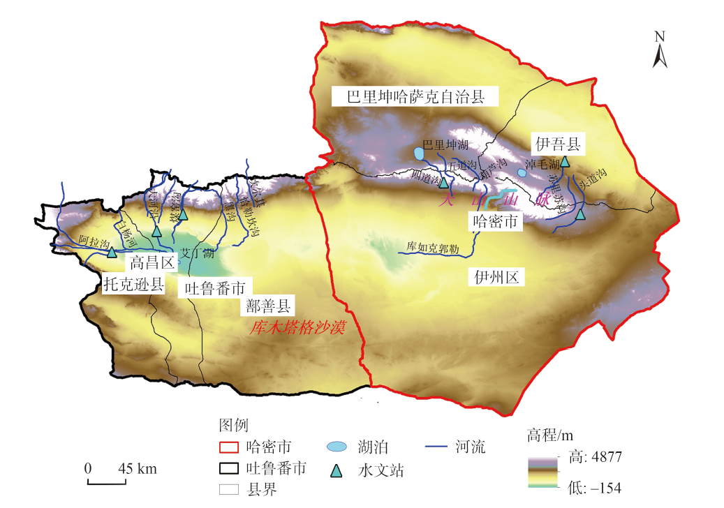

Fig. 2
Spatial distributions of greenness index in Turpan and Hami cities from 2000 to 2018"

Tab. 1
Statistical analysis of each index in Turpan and Hami cities from 2000 to 2018"
| 年份 | 统计参量 | 绿度指数 | 湿度指数 | 干度指数 | 热度指数 | RSEI |
|---|---|---|---|---|---|---|
| 2000 | 均值 | 0.1015 | 0.3158 | 0.6503 | 0.7538 | 0.1745 |
| 标准差 | 0.1010 | 0.0912 | 0.0587 | 0.1205 | 0.1267 | |
| 2006 | 均值 | 0.1060 | 0.3134 | 0.6671 | 0.7392 | 0.1815 |
| 标准差 | 0.1065 | 0.0894 | 0.0579 | 0.1189 | 0.1281 | |
| 2012 | 均值 | 0.1102 | 0.3626 | 0.6358 | 0.7253 | 0.1820 |
| 标准差 | 0.1159 | 0.0974 | 0.0622 | 0.1208 | 0.1353 | |
| 2018 | 均值 | 0.1259 | 0.3240 | 0.6627 | 0.7297 | 0.1709 |
| 标准差 | 0.1292 | 0.0907 | 0.0706 | 0.1261 | 0.1415 |
Fig. 3
Spatial distributions of wetness index in Turpan and Hami cities from 2000 to 2018"

Fig. 4
Spatial distributions of dryness index in Turpan and Hami cities from 2000 to 2018"


Fig. 5
Spatial distributions of heat index in Turpan and Hami cities from 2000 to 2018"
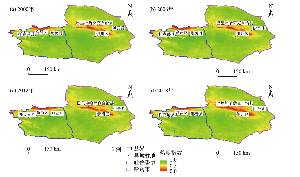
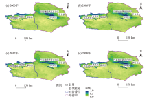
Fig. 6
Spatial distribution of remote sensing ecological index (RSEI) in Turpan and Hami cities from 2000 to 2018"

Tab. 2
Mean values of RSEI in counties and distvicts of Turpan and Hami cities at different periods"
| 县(区) | 2000年 | 2006年 | 2012年 | 2018年 |
|---|---|---|---|---|
| 高昌区 | 0.47 | 0.45 | 0.48 | 0.44 |
| 鄯善县 | 0.45 | 0.43 | 0.47 | 0.41 |
| 托克逊县 | 0.46 | 0.44 | 0.47 | 0.43 |
| 伊州区 | 0.47 | 0.45 | 0.49 | 0.44 |
| 巴里坤哈萨克自治县 | 0.45 | 0.42 | 0.46 | 0.43 |
| 伊吾县 | 0.45 | 0.42 | 0.46 | 0.42 |
Tab. 3
Correlation between RSEI and various indices at different periods"
| 年份 | 绿度指数 | 湿度指数 | 干度指数 | 热度指数 |
|---|---|---|---|---|
| 2000 | 0.8514 | 0.4289 | -0.7885 | -0.9134 |
| 2006 | 0.8702 | 0.3634 | -0.8154 | -0.8910 |
| 2012 | 0.8513 | 0.4342 | -0.8519 | -0.8777 |
| 2018 | 0.9139 | 0.4334 | -0.8744 | -0.8885 |
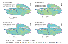
Fig. 7
Changes of greenness index in Turpan and Hami cities at different periods"

Tab. 4
Changes of RSEI and its covariates in Turpan and Hami cities at different periods"
| 时期 | 统计参量 | 绿度指数 | 湿度指数 | 干度指数 | 热度指数 | RSEI |
|---|---|---|---|---|---|---|
| 2000—2006年 | 均值 | 0.0044 | -0.0024 | 0.0168 | -0.0146 | 0.0069 |
| 标准差 | 0.0290 | 0.0384 | 0.0184 | 0.0354 | 0.0319 | |
| 2006—2012年 | 均值 | 0.0042 | 0.0492 | -0.0313 | -0.0140 | 0.0005 |
| 标准差 | 0.0318 | 0.0436 | 0.0188 | 0.0347 | 0.0331 | |
| 2012—2018年 | 均值 | 0.0157 | -0.0386 | 0.0269 | 0.0045 | -0.0112 |
| 标准差 | 0.0409 | 0.0438 | 0.0246 | 0.0302 | 0.0350 | |
| 2000—2018年 | 均值 | 0.0244 | 0.0082 | 0.0124 | -0.0241 | -0.0037 |
| 标准差 | 0.0533 | 0.0413 | 0.0311 | 0.0320 | 0.0420 |

Fig. 8
Changes of wetness index in Turpan and Hami cities at different periods"
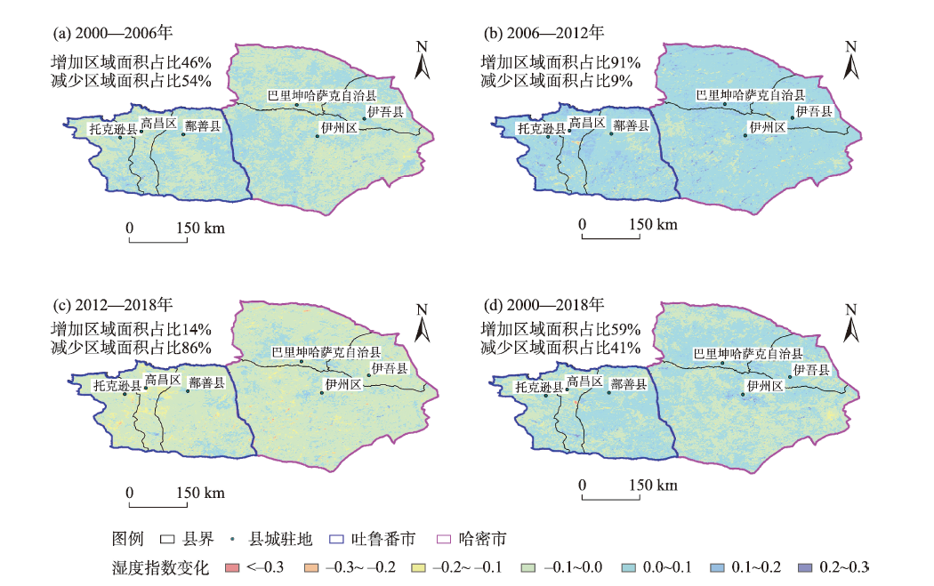
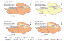
Fig. 9
Changes of dryness index in Turpan and Hami cities at different periods"

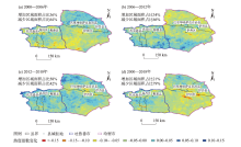
Fig. 10
Changes of heat index in Turpan and Hami cities at different periods"
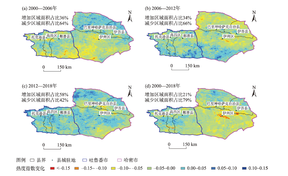

Fig. 11
Changes of RSEI in Turpan and Hami cities at different periods"
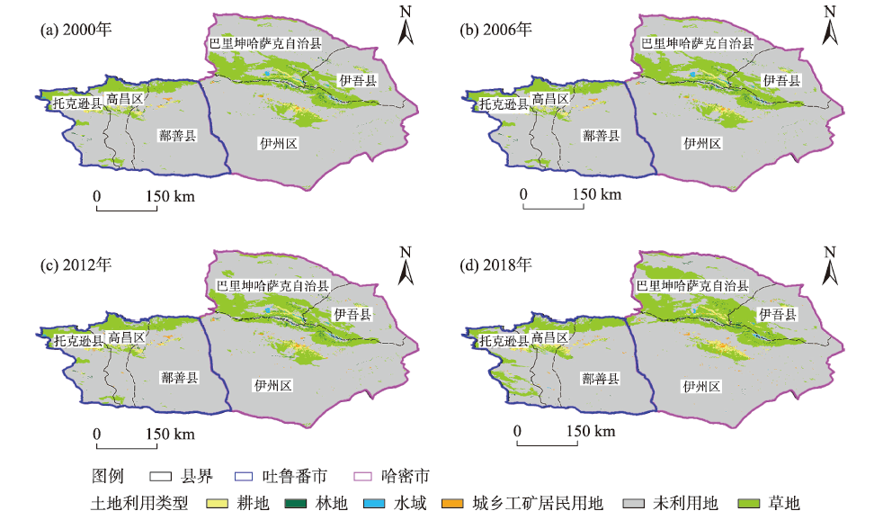
Fig. 12
Land use classification in Turpan and Hami cities at different periods"
Tab. 5
Area statistics of different land use types in Turpan and Hami cities /km2"
| 土地利用类型 | 2000年 | 2006年 | 2012年 | 2018年 |
|---|---|---|---|---|
| 耕地 | 2216 | 2285 | 2322 | 3085 |
| 林地 | 873 | 877 | 869 | 563 |
| 草地 | 30336 | 30352 | 30353 | 38380 |
| 水域 | 412 | 427 | 441 | 300 |
| 城乡用地 | 399 | 403 | 704 | 993 |
| 未利用地 | 172550 | 172598 | 172253 | 163465 |
Tab. 6
Transfer area of different land use types in Turpan and Hami cities from 2000 to 2018 /km2"
| 2000年 | 2018年 | ||||||
|---|---|---|---|---|---|---|---|
| 耕地 | 林地 | 草地 | 水域 | 城乡用地 | 未利用地 | 合计 | |
| 耕地 | 1636 | 4 | 327 | 4 | 124 | 121 | 2216 |
| 林地 | 130 | 152 | 442 | 1 | 13 | 135 | 873 |
| 草地 | 682 | 322 | 24028 | 41 | 121 | 5142 | 30336 |
| 水域 | 12 | 0 | 84 | 102 | 1 | 213 | 412 |
| 城乡用地 | 82 | 1 | 16 | 0 | 161 | 139 | 399 |
| 未利用地 | 543 | 84 | 13483 | 152 | 573 | 157715 | 172550 |
| 合计 | 3085 | 563 | 38380 | 300 | 993 | 163465 | - |
| [1] | 欧阳志云, 王效科, 苗鸿. 中国陆地生态系统服务功能及其生态经济价值的初步研究[J]. 生态学报, 1999, 19(5): 19-25. |
| [Ouyang Zhiyun, Wang Xiaoke, Miao Hong. A primary study on Chinese terrestrial ecosystem services and their ecological-economic values[J]. Acta Ecologica Sinica, 1999, 19(5): 19-25. ] | |
| [2] | 黄金川, 方创琳. 城市化与生态环境交互耦合机制与规律性分析[J]. 地理研究, 2003, 22(2): 211-220. |
| [Huang Jinchuan, Fang Chuanglin. Analysis of coupling mechanism and reles between urbanization and eco-enviroment[J]. Geographical Research, 2003, 22(2): 211-220. ] | |
| [3] | 刘纪远, 布和敖斯尔. 中国土地利用变化现代过程时空特征的研究──基于卫星遥感数据[J]. 第四纪研究, 2000, 20(3): 229-239. |
| [Liu Jiyuan, Buheaosier. Study on the spatial-temporal feature of modern land-use change in China: Using remote sensing techniques[J]. Quaternary Sciences, 2000, 20(3): 229-239. ] | |
| [4] | 顾留碗, 潘立新, 王帅帅, 等. 以土地利用为基础的安徽省生态评价遥感信息模型[J]. 水土保持通报, 2015, 35(5): 340-344, 350. |
| [Gu Liuwan, Pan Lixin, Wang Shuaishuai, et al. Remote sensing information model for ecological quality assessment in Anhui Province based on land use[J]. Bulletin of Soil and Water Conservation, 2015, 35(5): 340-344, 350. ] | |
| [5] | 戚曌, 于新文, 谭炳香, 等. 神农架地区生态环境遥感监测与恢复治理评价[J]. 林业科学研究, 2021, 34(6): 90-98. |
| [Qi Zhu, Yu Xinwen, Tan Bingxiang, et al. Remote sensing monitoring and restoration evaluation of ecological environment in Shennongjia Area[J]. Forest Research, 2021, 34(6): 90-98. ] | |
| [6] | 徐涵秋. 城市遥感生态指数的创建及其应用[J]. 生态学报, 2013, 33(24): 7853-7862. |
| [Xu Hanqiu. A remote urban ecological index and its application[J]. Acta Ecologica Sinica, 2013, 33(24): 7853-7862. ] | |
| [7] | 周萌, 刘友存, 孟丽红, 等. 基于遥感生态指数的东江源区2000—2019年生态环境质量评价[J]. 水土保持通报, 2021, 41(4): 231-240. |
| [Zhou Meng, Liu Youcun, Meng Lihong, et al. Evaluation of ecological environment quality of Dongjiang River Headwaters based on remote sensing ecological index during 2000—2019[J]. Bulletin of Soil and Water Conservation, 2021, 41(4): 231-240. ] | |
| [8] | 徐敏, 陈俊, 邓嘉翔, 等. 基于遥感生态指数的滁州市生态环境变化分析[J]. 地矿测绘, 2021, 37(2): 21-24. |
| [Xu Min, Chen Jun, Deng Jiaxiang, et al. Analysis of ecological environment changes in Chuzhou City based on remote sensing ecological index[J]. Surveying and Mapping of Geology and Mineral Resources, 2021, 37(2): 21-24. ] | |
| [9] | 何洪林, 彭补拙, 王良健, 等. 吐鲁番水土资源开发利用动态分析[J]. 山地研究, 1998(3): 198-204. |
| [He Honglin, Peng Buzhuo, Wang Liangjian, et al. The studies on the dynamic imitation for utilization of water and land resources in Turpan City[J]. Mountain Research, 1998(3): 198-204. ] | |
| [10] | 胡汝骥, 姜逢清, 王亚俊. 新疆雪冰水资源的环境评估[J]. 干旱区研究, 2003, 20(3): 187-191. |
| [Hu Ruji, Jiang Fengqing, Wang Yajun. Assessment on the glacial water resources in Xinjiang, China[J]. Arid Zone Research, 2003, 20(3): 187-191. ] | |
| [11] | 阿依努尔·麦提努日, 麦麦提吐尔逊·艾则孜, 麦尔哈巴·图尔贡, 等. 吐鲁番盆地葡萄园土壤重金属铅含量高光谱估算[J]. 遥感技术与应用, 2021, 36(2): 362-371. |
| [Medinur Ainur, Azezi Mediturson, Turgon Merhaba, et al. Hyperspectral estimation of heavy metal Pb concentration in vineyard soil in Turpan Basin[J]. Remote Sensing Technology and Application, 2021, 36(2): 362-371. ] | |
| [12] | 马子龙, 毛潇萱, 丁中原, 等. 新疆哈密地区有机氯农药大气、土壤残留特征、气-土交换及潜在生态风险[J]. 环境科学, 2013, 34(3): 1120-1128. |
| [Ma Zilong, Mao Xiaoxuan, Ding Zhongyuan, et al. Residual levels in air, soil and soil-air exchange of organochlorine pesticides in Hami Region of Xinjiang and its potential ecological risk[J]. Environmental Science, 2013, 34(3): 1120-1128. ] | |
| [13] |
宋慧敏, 薛亮. 基于遥感生态指数模型的渭南市生态环境质量动态监测与分析[J]. 应用生态学报, 2016, 27(12): 3913-3919.
doi: 10.13287/j.1001-9332.201612.024 |
|
[Song Huimin, Xue Liang. Dynamic monitoring and analysis of ecological environment in Weinan City, northwest China based on RSEI model[J]. Chinese Journal of Applied Ecology, 2016, 27(12): 3913-3919. ]
doi: 10.13287/j.1001-9332.201612.024 |
|
| [14] | 王丽春, 焦黎, 来风兵, 等. 基于遥感生态指数的新疆玛纳斯湖湿地生态变化评价[J]. 生态学报, 2019, 39(8): 2963-2972. |
| [Wang Lichun, Jiao Li, Lai Fengbing, et al. Evaluation of ecological changes based on a remote sensing ecological index in a Manas Lake wetland, Xinjiang[J]. Acta Ecologica Sinica, 2019, 39(8): 2963-2972. ] | |
| [15] |
孟岩, 赵庚星, 程晋南, 等. 基于MODIS遥感数据和GIS的山东省生态环境状况评价[J]. 中国生态农业学报, 2008, 16(4): 1020-1024.
doi: 10.3724/SP.J.1011.2008.01020 |
|
[Meng Yan, Zhao Gengxing, Cheng Jinnan, et al. Evaluation of ecological environment of Shandong Province using MODIS data and GIS platform[J]. Chinese Journal of Eco-Agriculture, 2008, 16(4): 1020-1024. ]
doi: 10.3724/SP.J.1011.2008.01020 |
|
| [16] |
Xu H Q, Wang Y F, Guan H D, et al. Detecting ecological changes with a remote sensing based ecological index (RSEI) produced time series and change vector analysis[J]. Remote Sensing, 2019, 11(20): 2345, doi: 10.3390/rs11202345.
doi: 10.3390/rs11202345 |
| [17] | 李博伦, 遆超普, 颜晓元. Landsat 8陆地成像仪影像的缨帽变换推导[J]. 测绘科学, 2016, 41(4): 102-107. |
| [Li Bolun, Ti Chaopu, Yan Xiaoyuan. Study of derivation of tasseled cap transformation of Landsat 8 OLI images[J]. Science of Surveying and Mapping, 2016, 41(4): 102-107. ] | |
| [18] | 王正兴, 刘闯, Huete Alfredo. 植被指数研究进展: 从AVHRR-NDVI到MODIS-EVI[J]. 生态学报, 2003, 23(5): 979-987. |
| [Wang Zhengxing, Liu Chuang, Huete Alfredo. From AVHRR-NDVI to MODIS-EVI: Advances in vegetation index research[J]. Acta Ecologica Sinica, 2003, 23(5): 979-987. ] | |
| [19] |
Yang J, Huang X. The 30 m annual land cover dataset and its dynamics in China from 1990 to 2019[J]. Earth System Science Data, 2021, 13(8): 3907-3925.
doi: 10.5194/essd-13-3907-2021 |
| [20] | 刘瑞, 朱道林. 基于转移矩阵的土地利用变化信息挖掘方法探讨[J]. 资源科学, 2010, 32(8): 1544-1550. |
| [Liu Rui, Zhu Daolin. Methods for detecting land use changes based on the land use transition matrix[J]. Resources Science, 2010, 32(8): 1544-1550. ] | |
| [21] |
吴琳娜, 杨胜天, 刘晓燕, 等. 1976年以来北洛河流域土地利用变化对人类活动程度的响应[J]. 地理学报, 2014, 69(1): 54-63.
doi: 10.11821/dlxb201401005 |
|
[Wu Linna, Yang Shengtian, Liu Xiaoyan, et al. Response analysis of land use change to the degree of human activities in Beiluo River Basin since 1976[J]. Acta Geographica Sinica, 2014, 69(1): 54-63. ]
doi: 10.11821/dlxb201401005 |
|
| [22] | 帕茹克·吾斯曼江, 郝晋珉, 王楠, 等. 基于“三生”功能的土地利用转型及其生态环境效应——以尉犁县为例[J]. 干旱区地理, 2021, 44(6): 1612-1622. |
| [Wusimanjiang Parruk, Hao jinmin, Wang Nan, et al. Land use transformation based on production-living-ecological functions and associated eco-environment effects: A case study in Yuli County[J]. Arid Land Geography, 2021, 44(6): 1612-1622. ] | |
| [23] | 刘畅, 李诚志, 李胜辉, 等. 基于栅格累加法的塔里木盆地沙漠化分析[J]. 干旱区地理, 2021, 44(1): 197-207. |
| [Liu Chang, Li Chengzhi, Li Shenghui, et al. Desertification analysis based on grid accumulation method in Tarim Basin, China[J]. Arid Land Geography, 2021, 44(1): 197-207. ] | |
| [24] | 杨国清, 刘耀林, 吴志峰. 基于CA-Markov模型的土地利用格局变化研究[J]. 武汉大学学报(信息科学版), 2007, 32(5): 414-418. |
| [Yang Guoqing, Liu Yaolin, Wu Zhifeng. Analysis and simulation of land-use temporal and spatial pattern based on CA-Markov model[J]. Geomatics and Information Science of Wuhan University, 2007, 32(5): 414-418. ] |
| [1] | WANG Jian, GUAN Yao, HE Xinghong, DAI Yunhao, CHEN Yiwei, WANG Yuqiang, LI Huiwen, FAN Debao. Dynamic monitoring and evaluation of ecological environment quality in Tumshuk City from 2000 to 2021 [J]. Arid Land Geography, 2024, 47(3): 465-473. |
| [2] | CHEN Yueping, WU Shengli, ZHAO Xin, ZHANG Yijia. Spatial and temporal variation characteristics of extreme temperatures in Hami City in the past 60 years [J]. Arid Land Geography, 2023, 46(6): 868-879. |
| [3] | MA Li’na, ZHANG Feiyun, ZHAI Yuxin, TENG Lun, KANG Jianguo. Temporal and spatial evolution of ecosystem service value under land use change in Xinjiang from 1980 to 2020 [J]. Arid Land Geography, 2023, 46(2): 253-263. |
| [4] | ZHANG Zhigao, XU Xiaoman, GUO Chaofan, CAI Maotang, YUAN Zheng, ZHANG Mingzhe. Spatial and temporal characteristics and influencing factors of frost date in the Yellow River Basin from 1960 to 2020 [J]. Arid Land Geography, 2022, 45(6): 1685-1694. |
| [5] | SUN Guili,LI Xue,LIU Yanyan,ZHENG Jiaxiang,MA Jing,RAN Yajun. Dynamic changes on desertification risk assessment and driving force analysis in Turpan City [J]. Arid Land Geography, 2022, 45(2): 401-412. |
| [6] | WANG Liping,DUAN Sibo,ZHANG Xiaoyu,YU Yanru. Spatio-temporal distribution and variation characteristics of annual maximum land surface temperature in China during 2003-2018 [J]. Arid Land Geography, 2021, 44(5): 1299-1308. |
| [7] | WANG Mei-xia, ZHANG Tai-xi, YU Xing-jie, ZHANG Lian-cheng, ZHANG Xu. Estimation and application of water-collecting amount during an extreme heavy rainfall induced flash flooding in Hami City on 31st July 2018 [J]. Arid Land Geography, 2020, 43(4): 939-945. |
| [8] | JING Yue, SUN Yan-ling, GAO Shuang, CHEN Li, PAN Long, MA Han. Spatiotemporal variations of AOD and geographical detection of its influence factors in Beijing-Tianjin-Hebei region [J]. Arid Land Geography, 2020, 43(1): 87-98. |
| [9] | ZHAO Ming-wei, WANG Ni, SHI Hui-hui, JIANG Ling, WANG Chun. Spatial-temporal variation and its driving forces of vegetation coverage in China from 2001 to 2015 [J]. Arid Land Geography, 2019, 42(2): 324-331. |
| [10] | . Projections of spatial-temporal variation of drought in north China [J]. , 2015, 38(2): 239-248. |
|
||