Arid Land Geography ›› 2022, Vol. 45 ›› Issue (2): 413-422.doi: 10.12118/j.issn.1000–6060.2021.308
• Earth Surface Process • Previous Articles Next Articles
ZHANG Yuhan1( ),ZHOU Pu2(),ZHAO Yu3
Received:2021-07-07
Revised:2021-10-16
Online:2022-03-25
Published:2022-04-02
Contact:
Pu ZHOU
E-mail:zhangyuhanwinter@sina.com;zhoupu1102@163.com
ZHANG Yuhan,ZHOU Pu,ZHAO Yu. Temporal and spatial pattern of coal mining sites’ stress on key ecological protection areas in the Yellow River Basin from 2012 to 2019[J].Arid Land Geography, 2022, 45(2): 413-422.
Tab. 1
Overlapping between coal mine sites and key ecological protection areas and the changes of spatial stress index in the Yellow River Basin"
| 重要生态保护空间 | 2012年重叠面积/km2 | 2012年空间胁迫指数/% | 2019年重叠面积/km2 | 2019年空间胁迫指数/% |
|---|---|---|---|---|
| 重要生态保护空间 | 14730 | 0.88 | 17008 | 1.01 |
| 重要土壤保持功能区 | 4052 | 1.90 | 4272 | 2.00 |
| 重要水源涵养功能区 | 484 | 0.11 | 115 | 0.03 |
| 重要生物多样性维持与保护功能区 | 316 | 0.06 | 68 | 0.01 |
| 重要防风固沙功能区 | 10835 | 1.54 | 13443 | 1.91 |
| 沙漠化敏感区 | 6114 | 1.12 | 8073 | 1.47 |
| 盐渍化敏感区 | 584 | 0.18 | 566 | 0.18 |
| 土壤侵蚀敏感区 | 4027 | 1.88 | 4247 | 1.99 |
| 酸雨敏感区 | 372 | 0.55 | 303 | 0.45 |
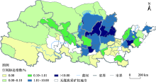
Fig. 1
Spatial stress index of coal mining sites on key ecological protection areas in the Yellow River Basin in 2019"
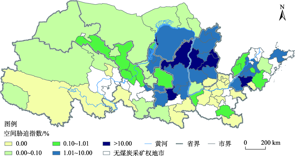
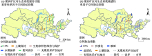
Fig. 2
Spatial stress index of coal mining sites on single factors of ecosystem service function importance and ecological sensitivity in the Yellow River Basin in 2019"


Fig. 3
Distribution of spatial stress index changes of coal mining sites on key ecological protection areas in the Yellow River Basin from 2012 to 2019"

Tab. 2
Change of overlapping between coal mining sites and key ecological protection areas and spatial stress index in the cities of Yellow River Basin"
| 地市 | 2019年重叠面积/km2 | 2012—2019年重叠面积变化/km2 | 2012—2019年胁迫指数变化/% | 地市 | 2019年重叠面积/km2 | 2012—2019年重叠面积变化/km2 | 2012—2019年胁迫指数变化/% |
|---|---|---|---|---|---|---|---|
| 铜川 | 12.4 | -68.0 | -6.7270 | 聊城 | 11.9 | -0.5 | -0.0062 |
| 太原 | 205.3 | -118.3 | -5.2698 | 甘南 | 0.0 | -1.2 | -0.0044 |
| 阳泉 | 145.3 | -22.1 | -3.6483 | 运城 | 2.1 | -0.1 | -0.0013 |
| 淄博 | 43.7 | -106.0 | -3.0842 | 德州 | 96.9 | -0.1 | -0.0007 |
| 济宁 | 1011.8 | -85.5 | -1.8067 | 果洛 | 0.0 | -0.3 | -0.0004 |
| 济南 | 124.5 | -82.6 | -1.4097 | 驻马店 | 27.7 | -0.1 | -0.0002 |
| 渭南 | 131.5 | -28.6 | -1.0630 | 玉树 | 0.0 | -0.3 | -0.0001 |
| 石嘴山 | 41.0 | -42.0 | -1.0326 | 固原 | 3.7 | 0.0 | 0.0000 |
| 安康 | 0.0 | -219.2 | -0.9783 | 临沂 | 4.1 | 0.0 | 0.0000 |
| 乌海 | 192.7 | -15.9 | -0.9401 | 长治 | 33.1 | 0.0 | 0.0000 |
| 泰安 | 164.3 | -35.2 | -0.9391 | 安阳 | 0.0 | 0.0 | 0.0000 |
| 大同 | 764.8 | -98.2 | -0.8417 | 鹤壁 | 0.0 | 0.0 | 0.0000 |
| 临汾 | 160.7 | -54.0 | -0.7273 | 焦作 | 0.0 | 0.0 | 0.0000 |
| 晋中 | 187.2 | -8.7 | -0.6109 | 晋城 | 0.0 | 0.0 | 0.0000 |
| 忻州 | 372.5 | -59.8 | -0.3722 | 平顶山 | 0.0 | 0.0 | 0.0000 |
| 白银 | 33.0 | -27.4 | -0.3203 | 商丘 | 0.0 | 0.0 | 0.0000 |
| 烟台 | 44.7 | -11.2 | -0.3035 | 新乡 | 0.0 | 0.0 | 0.0000 |
| 金昌 | 0.1 | -17.3 | -0.2539 | 许昌 | 0.0 | 0.0 | 0.0000 |
| 张掖 | 52.8 | -95.5 | -0.2539 | 枣庄 | 0.0 | 0.0 | 0.0000 |
| 兰州 | 15.2 | -16.9 | -0.2285 | 郑州 | 0.0 | 0.0 | 0.0000 |
| 三门峡 | 11.9 | -3.8 | -0.2156 | 济源 | 0.0 | 0.0 | 0.0000 |
| 洛阳 | 0.0 | -1.9 | -0.2114 | 呼和浩特 | 9.4 | 0.0 | 0.0000 |
| 汉中 | 23.8 | -47.2 | -0.1845 | 海西 | 75.2 | 54.1 | 0.0197 |
| 中卫 | 2.8 | -10.9 | -0.1502 | 莱芜 | 4.1 | 0.6 | 0.1353 |
| 潍坊 | 3.1 | -9.6 | -0.1142 | 延安 | 619.0 | 35.0 | 0.1475 |
| 武威 | 87.7 | -27.1 | -0.0861 | 平凉 | 121.9 | 16.4 | 0.2382 |
| 陇南 | 1.3 | -18.5 | -0.0735 | 朔州 | 706.2 | 62.2 | 0.5943 |
| 包头 | 8.1 | -12.8 | -0.0508 | 吴忠 | 216.4 | 103.1 | 0.7220 |
| 海北 | 31.0 | -14.3 | -0.0418 | 吕梁 | 997.7 | 78.8 | 0.7986 |
| 西宁 | 0.0 | -0.6 | -0.0295 | 银川 | 364.7 | 64.7 | 0.8629 |
| 商洛 | 0.0 | -4.3 | -0.0232 | 宝鸡 | 122.0 | 87.3 | 0.9278 |
| 酒泉 | 5.4 | -19.8 | -0.0198 | 鄂尔多斯 | 4318.9 | 813.7 | 0.9519 |
| 庆阳 | 108.2 | -3.0 | -0.0165 | 菏泽 | 159.0 | 22.9 | 1.2762 |
| 巴彦淖尔 | 26.7 | -8.5 | -0.0156 | 榆林 | 4779.5 | 2165.5 | 5.2897 |
| 阿拉善 | 51.7 | -25.9 | -0.0129 | 咸阳 | 269.0 | 196.9 | 19.5448 |
| 信阳 | 0.0 | -0.8 | -0.0107 |
Tab. 3
Whether the key ecological protection areas were considered by the cities in the Yellow River Basin when coal mining sites withdraw or increase"
| 胁迫指数变化 | 类型 | 地市 |
|---|---|---|
| 胁迫指数降低 | 煤炭矿区退出优先考虑了重要生态保护空间 | 山西太原、阳泉、大同,内蒙古乌海、巴彦淖尔、阿拉善盟,山东济南、淄博、泰安、聊城、德州,河南洛阳、信阳,陕西铜川、渭南、安康、汉中、商洛,宁夏石嘴山、中卫,甘肃兰州、白银、金昌、张掖、酒泉、庆阳、甘南、武威、陇南,青海西宁、海北、果洛、玉树 |
| 煤炭矿区退出未优先考虑重要生态保护空间 | 山西临汾、晋中、忻州、运城,内蒙古包头,山东济宁、烟台、潍坊,河南三门峡、驻马店 | |
| 胁迫指数不变 | 煤炭矿区增加考虑了对重要生态保护空间的避让 | 山西长治、晋城 |
| 煤炭矿区退出未考虑重要生态保护空间 | 山东临沂,宁夏固原 | |
| 胁迫指数升高 | 煤炭矿区增加优先考虑了对重要生态保护空间的避让 | 山东菏泽,陕西延安、咸阳、宝鸡 |
| 煤炭矿区增加未优先考虑对重要生态保护空间的避让 | 山西朔州,内蒙古鄂尔多斯,山东莱芜,陕西榆林,甘肃平凉,青海海西,宁夏银川 |
| [1] | 习近平. 在黄河流域生态保护和高质量发展座谈会上的讲话[J]. 中国水利, 2019(20):1-3. |
| [ Xi Jinping. Speech at the symposium on ecological protection and high-quality development of the Yellow River Basin[J]. China Water Resources, 2019(20):1-3. ] | |
| [2] | 杨永春, 穆焱杰, 张薇. 黄河流域高质量发展的基本条件与核心策略[J]. 资源科学, 2020, 42(3):409-423. |
| [ Yang Yongchun, Mu Yanjie, Zhang Wei. Basic conditions and core strategies of high-quality development in the Yellow River Basin[J]. Resources Science, 2020, 42(3):409-423. ] | |
| [3] | 赵剑波, 史丹, 邓洲. 高质量发展的内涵研究[J]. 经济与管理研究, 2019, 40(11):15-31. |
| [ Zhao Jianbo, Shi Dan, Deng Zhou. A framework of China’s high-quality economic development[J]. Research on Economics and Management, 2019, 40(11):15-31. ] | |
| [4] | 史丹. 绿色发展与全球工业化的新阶段: 中国的进展与比较[J]. 中国工业经济, 2018(10):5-18. |
| [ Shi Dan. The green development and the new stage of industrialization: Progress in China and comparison with other[J]. China Industrial Economics, 2018(10):5-18. ] | |
| [5] | 金凤君, 马丽, 许堞. 黄河流域产业发展对生态环境的胁迫诊断与优化路径识别[J]. 资源科学, 2020, 42(1):127-136. |
| [ Jin Fengjun, Ma Li, Xu Die. Environmental stress and optimized path of industrial development in the Yellow River Basin[J]. Resources Science, 2020, 42(1):127-136. ] | |
| [6] |
樊杰, 周侃, 孙威, 等. 人文-经济地理学在生态文明建设中的学科价值与学术创新[J]. 地理科学进展, 2013, 32(2):147-160.
doi: 10.11820/dlkxjz.2013.02.001 |
|
[ Fan Jie, Zhou Kan, Sun Wei, et al. Scientific values and research innovations of human-economic geography in construction of ecological civilization[J]. Progress in Geography, 2013, 32(2):147-160. ]
doi: 10.11820/dlkxjz.2013.02.001 |
|
| [7] | 沈镭, 高丽. 中国西部能源及矿业开发与环境保护协调发展研究[J]. 中国人口·资源与环境, 2013, 23(10):17-23. |
| [ Shen Lei, Gao Li. Managing energy and mineral resources development and pollution control coordinately in the western China[J]. China Population, Resources and Environment, 2013, 23(10):17-23. ] | |
| [8] | 周海魂, 黄新兰. 新疆煤炭资源开发与生态环境保护[J]. 中国煤炭, 2011, 37(6):16-19. |
| [ Zhou Haihun, Huang Xinlan. Coal resources development and ecological environment protection in Xinjiang[J]. China Coal, 2011, 37(6):16-19. ] | |
| [9] | 王旭, 周爱国, 甘义群, 等. 青藏高原矿产资源开发与地质环境保护协调发展的对策探讨[J]. 干旱区资源与环境, 2010, 24(2):69-73. |
| [ Wang Xu, Zhou Aiguo, Gan Yiqun, et al. Study on the harmonize development of mineral resources exploration and the geo-environment protection countermeasures in Qinghai-Tibet[J]. Journal of Arid Land Resources and Environment, 2010, 24(2):69-73. ] | |
| [10] | 吴亚男, 李元实. 煤炭开发布局西移对生态环境的影响及对策建议[J]. 环境影响评价, 2017, 39(4):10-12. |
| [ Wu Ya’nan, Li Yuanshi. Ecological environmental impact and its solutions to transfer of coal development to western regions[J]. Environmental Impact Assessment, 2017, 39(4):10-12. ] | |
| [11] | 赵玉婷, 邹广迅, 董林艳, 等. 西北煤炭开发生态风险管控区划分及管理策略[J]. 环境科学研究, 2019, 32(3):372-379. |
| [ Zhao Yuting, Zou Guangxun, Dong Linyan, et al. Division and management strategy of regional ecological risk control zonation for coal exploitation and utilization in northwest China[J]. Research of Environmental Sciences, 2019, 32(3):372-379. ] | |
| [12] | 潘换换, 吴树荣, 杨琪雪, 等. 山西煤田生态系统服务热(冷)点时空格局[J]. 干旱区地理, 2021, 44(6):1686-1695. |
| [ Pan Huanhuan, Wu Shurong, Yang Qixue, et al. Spatiotemporal pattern of hotspots (coldspots) of ecosystem services in coalfields of Shanxi Province[J]. Arid Land Geography, 2021, 44(6):1686-1695. ] | |
| [13] | 时进钢, 王亚男, 陈晓丽. 黄河中上游能源化工区大气污染跨界环境影响分析[J]. 环境监测管理与技术, 2011, 23(6):21-25. |
| [ Shi Jingang, Wang Ya’nan, Chen Xiaoli. Crossing boundary impact analysis of air pollutant in energy and chemical industry region of upper and middle reaches of the Yellow River[J]. The Administration and Technique of Environmental Monitoring, 2011, 23(6):21-25. ] | |
| [14] | 郭家新, 胡振琪, 袁冬竹, 等. 黄河流域下游煤矿采煤塌陷区耕地破碎化动态演变——以山东济宁市为例[J]. 煤炭学报, 2021, 46(9):3039-3055. |
| [ Guo Jiaxin, Hu Zhenqi, Yuan Dongzhu, et al. Dynamic evolution of cultivated land fragmentation in coal mining subsidence area of the lower Yellow River Basin: A case study of Jining City, Shandong Province[J]. Journal of China Coal Society, 2021, 46(9):3039-3055. ] | |
| [15] | 闫敬旺, 王树斌, 刘朝军. 黄河流域煤炭产业发展和生态环境保护的耦合关系研究[J]. 煤炭经济研究, 2021, 41(6):27-34. |
| [ Yan Jingwang, Wang Shubin, Liu Chaojun. Research on the coupling relationship between coal industry development and ecological environment protection in the Yellow River Basin[J]. Coal Economic Research, 2021, 41(6):27-34. ] | |
| [16] | 奥勇, 蒋嶺峰, 白召弟, 等. 基于格网GIS的黄河流域土地生态质量综合评价[J/OL]. 干旱区地理: 1-16. [2021-10-15]. http://kns.cnki.net/kcms/detail/65.1103.X.20210812.1543.006.html. |
| [ Ao Yong, Jiang Lingfeng, Bai Zhaodi, et al. Comprehensive evaluation of land ecological quality in the Yellow River Basin based on Grid-GIS[J/OL]. Arid Land Geography: 1-16. [2021-10-15]. http://kns.cnki.net/kcms/detail/65.1103.X.20210812.1543.006.html. ] | |
| [17] | 时光, 任慧君, 乔立瑾, 等. 黄河流域煤炭高质量发展研究[J]. 煤炭经济研究, 2020, 40(8):36-44. |
| [ Shi Guang, Ren Huijun, Qiao Lijin, et al. Research on high-quality development of coal in the Yellow River Basin[J]. Coal Economic Research, 2020, 40(8):36-44. ] | |
| [18] | 彭苏萍, 毕银丽. 黄河流域煤矿区生态环境修复关键技术与战略思考[J]. 煤炭学报, 2020, 45(4):1211-1221. |
| [ Peng Suping, Bi Yinli. Strategic consideration and core technology about environmental ecological restoration in coal mine areas in the Yellow River Basin of China[J]. Journal of China Coal Society, 2020, 45(4):1211-1221. ] | |
| [19] | 卞正富, 于昊辰, 雷少刚, 等. 黄河流域煤炭资源开发战略研判与生态修复策略思考[J]. 煤炭学报, 2021, 46(5):1378-1391. |
| [ Bian Zhengfu, Yu Haochen, Lei Shaogang, et al. Strategic consideration of exploitation on coal resources and its ecological restoration in the Yellow River Basin, China[J]. Journal of China Coal Society, 2021, 46(5):1378-1391. ] | |
| [20] | 马丽, 田华征, 康蕾. 黄河流域矿产资源开发的生态环境影响与空间管控路径[J]. 资源科学, 2020, 42(1):137-149. |
| [ Ma Li, Tian Huazheng, Kang Lei. Eco-environmental impact and spatial control of mineral resources exploitation in the Yellow River Basin[J]. Resources Science, 2020, 42(1):137-149. ] | |
| [21] | 张佰发, 苗长虹. 黄河流域土地利用时空格局演变及驱动力[J]. 资源科学, 2020, 42(3):460-473. |
| [ Zhang Baifa, Miao Changhong. Spatiotemporal changes and driving forces of land use in the Yellow River Basin[J]. Resources Science, 2020, 42(3):460-473. ] | |
| [22] | 欧阳志云, 王效科, 苗鸿. 中国生态环境敏感性及其区域差异规律研究[J]. 生态学报, 2000, 20(1):9-12. |
| [ Ouyang Zhiyun, Wang Xiaoke, Miao Hong. China’s eco-environmental sensitivity and its spatial heterogeneity[J]. Acta Ecologica Sinica, 2000, 20(1):9-12. ] | |
| [23] | 颜磊, 许学工, 谢正磊, 等. 北京市域生态敏感性综合评价[J]. 生态学报, 2009, 29(6):3117-3125. |
| [ Yan Lei, Xu Xuegong, Xie Zhenglei, et al. Integrated assessment on ecological sensitivity for Beijing[J]. Acta Ecologica Sinica, 2009, 29(6):3117-3125. ] | |
| [24] | 刘军会, 高吉喜, 马苏, 等. 中国生态环境敏感区评价[J]. 自然资源学报, 2015, 30(10):1607-1616. |
| [ Liu Junhui, Gao Jixi, Ma Su, et al. Evaluation of ecological sensitivity in China[J]. Journal of Natural Resources, 2015, 30(10):1607-1616. ] | |
| [25] | 傅伯杰, 周国逸, 白永飞, 等. 中国主要陆地生态系统服务功能与生态安全[J]. 地球科学进展, 2009, 24(6):571-576. |
| [ Fu Bojie, Zhou Guoyi, Bai Yongfei, et al. The main terrestrial ecosystem services and ecological security in China[J]. Advances in Earth Science, 2009, 24(6):571-576. ] | |
| [26] | 欧阳志云, 王如松, 赵景柱. 生态系统服务功能及其生态经济价值评价[J]. 应用生态学报, 1999, 10(5):635-640. |
| [ Ouyang Zhiyun, Wang Rusong, Zhao Jingzhu. Ecosystem services and their economic valuation[J]. Chinese Journal of Applied Ecology, 1999, 10(5):635-640. ] | |
| [27] | Daily G C. Natures services: Societal dependence on natural ecosystems[M]. Washington D C: Island Press, 1997. |
| [28] |
Liang C, Li X. The ecological sensitivity evaluation in Yellow River Delta National Natural Reserve[J]. Clean Soil Air Water, 2012, 40(10):1197-1207.
doi: 10.1002/clen.201200051 |
| [29] | 崔彬, 牛建英, 李超峰, 等. 现代矿产资源经济学[M]. 北京: 中国人民大学出版社, 2015. |
| [ Cui Bin, Niu Jianying, Li Chaofeng, et al. Modern mineral resource economics[M]. Beijing: China Renmin University Press, 2015. ] | |
| [30] | 吴喜军, 李怀恩, 董颖. 煤炭开采对水资源影响的定量识别——以陕北窟野河流域为例[J]. 干旱区地理, 2016, 39(2):246-253. |
| [ Wu Xijun, Li Huai’en, Dong Ying. Quantitative recognition of coal mining on water resources influence: A case of Kuye River in northern Shaanxi[J]. Arid Land Geography, 2016, 39(2):246-253. ] | |
| [31] | 陈介福, 东野光亮, 张志国. 试论煤炭资源开发对生态环境的影响[J]. 中国人口·资源与环境, 1989, 1(1):68-72. |
| [ Chen Jiefu, Dongye Guangliang, Zhang Zhiguo. Discussion on the coal resource exploitation and the effect to ecological environment[J]. China Population, Resources and Environment, 1989, 1(1):68-72. ] | |
| [32] | 吴晓华, 潘卫东. 我国煤炭资源开发生态环境影响调查[J]. 中国科技论文, 2014, 9(5):600-604. |
| [ Wu Xiaohua, Pan Weidong. Investigation of effect of coal resources exploitation on ecological environment in China[J]. China Science Paper, 2014, 9(5):600-604. ] | |
| [33] | 毛国力, 程宏光, 张璐璐, 等. 煤炭资源开发对生态环境的影响与对策分析[J]. 煤炭与化工, 2013, 36(12):141-142, 145. |
| [ Mao Guoli, Cheng Hongguang, Zhang Lulu, et al. Coal resources development influencing ecological environment and the countermeasure analysis[J]. Coal and Chemical Industry, 2013, 36(12):141-142, 145. ] | |
| [34] | 贾宗谦, 吕向前, 胡思虎, 等. 甘肃省煤炭资源开发对生态环境影响的探讨[J]. 能源环境保护, 2020, 34(5):104-108. |
| [ Jia Zongqian, Lü Xiangqian, Hu Sihu, et al. Discussion on the influence of coal resource development on ecological environment in Gansu Province[J]. Energy Environmental Protection, 2020, 34(5):104-108. ] | |
| [35] | 黄翌, 汪云甲, 田丰, 等. 煤炭开采对植被-土壤系统扰动的碳效应研究[J]. 资源科学, 2014, 36(4):817-823. |
| [ Huang Yi, Wang Yunjia, Tian Feng, et al. Carbon disturbance effects in the vegetation-soil system caused by coal mining[J]. Resources Science, 2014, 36(4):817-823. ] | |
| [36] | 武强, 刘伏昌, 李铎. 矿山环境研究理论与实践[M]. 北京: 地质出版社, 2005. |
| [ Wu Qiang, Liu Fuchang, Li Duo. Theoretical and practical research on mine environment[M]. Beijing: Geological Publishing House, 2005. ] |
|
||