Arid Land Geography ›› 2024, Vol. 47 ›› Issue (9): 1451-1461.doi: 10.12118/j.issn.1000-6060.2023.636
• The Third Xinjiang Scientific Expedition • Previous Articles Next Articles
LIU Hui1,2( ), SUN Siao1,2(), FANG Chuanglin1,2, ZHOU Di3, BAO Chao1,2
Received:2023-11-09
Revised:2024-04-16
Online:2024-09-25
Published:2024-09-24
Contact:
SUN Siao
E-mail:liuhui0026@igsnrr.ac.cn;suns@igsnrr.ac.cn
LIU Hui, SUN Siao, FANG Chuanglin, ZHOU Di, BAO Chao. Spatiotemporal evolutionary patterns and influencing factors of water use in Xinjiang from 1990 to 2020[J].Arid Land Geography, 2024, 47(9): 1451-1461.

Fig. 1
Per capita water resources and water utilization rate in each prefecture of Xinjiang in 2020"


Fig. 2
Trend of water use in Xinjiang from 1990 to 2020"
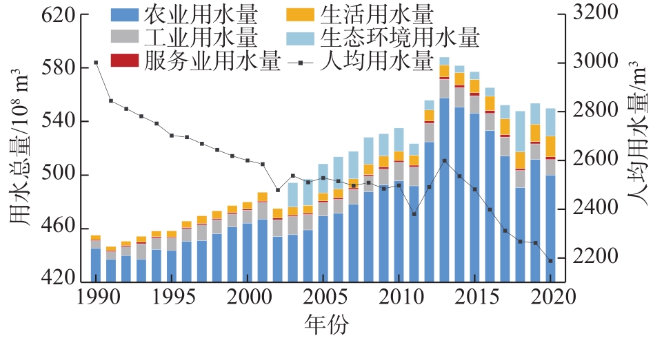
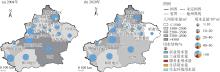
Fig. 3
Total water use, water use structure and per capita water use in prefectures of Xinjiang"


Fig. 4
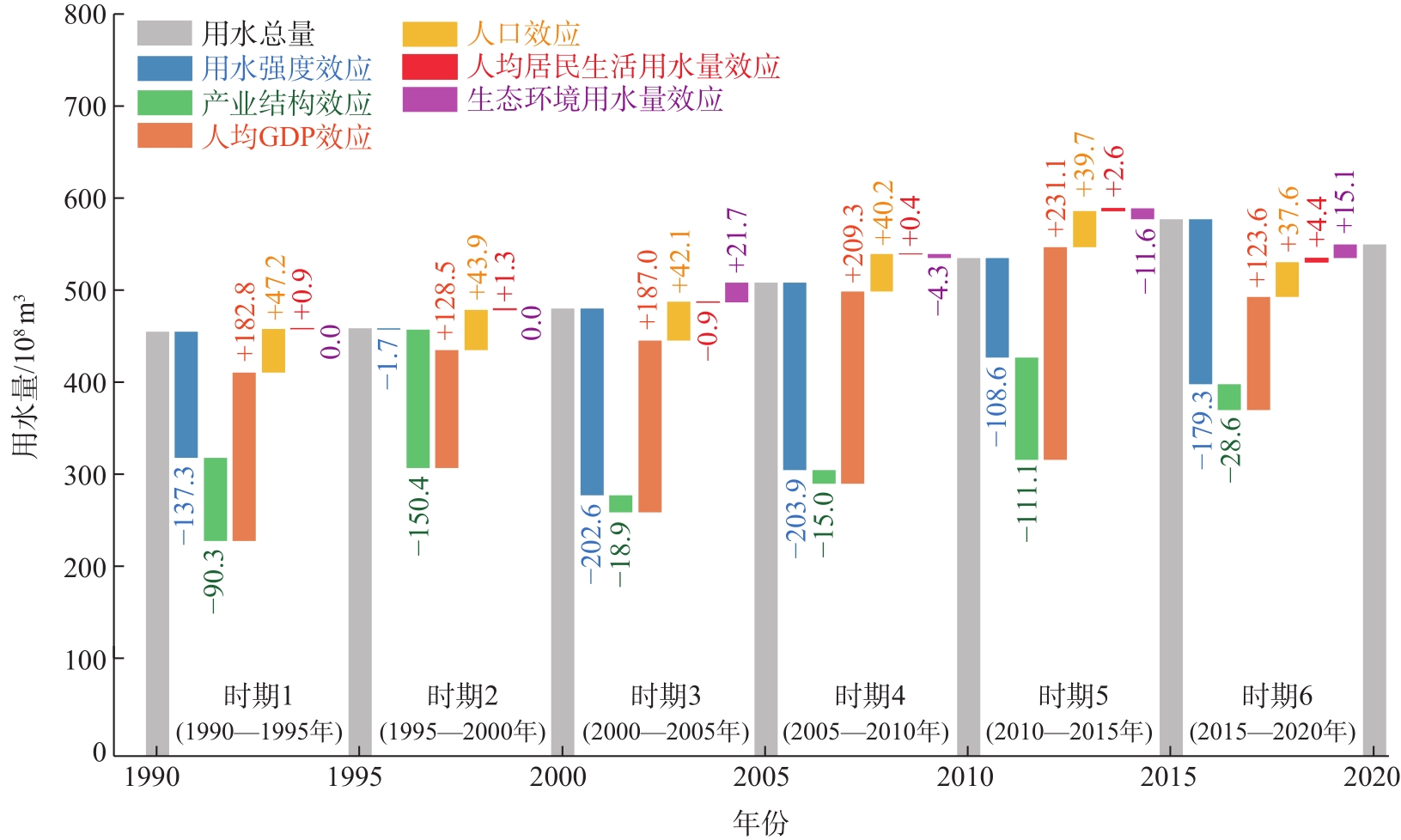
Decomposition results of influencing factors of total water use changes in Xinjiang from 1990 to 2020"
Tab. 1
Accumulative effects of influencing factors of total water use changes in Xinjiang from 1990 to 2020"
| 指标 | 用水强度 | 产业结构 | 人均GDP | 人口 | 人均居民生活用水量 | 生态环境用水量 | 用水总量变化量 |
|---|---|---|---|---|---|---|---|
| 累计效应/108 m3 | -833.4 | -414.4 | 1062.3 | 250.6 | 8.7 | 20.9 | 94.8 |
| 累计贡献率/% | -879.1 | -437.1 | 1120.6 | 264.4 | 9.2 | 22.0 | 100.0 |
Tab. 2
Difference in per capita water uses between Xinjiang and northwest China or whole China"
| 组别 | 年份 | 效应/m3(贡献率/%) | 人均用水量差异/m3 | ||||
|---|---|---|---|---|---|---|---|
| 用水强度 | 产业结构 | 人均GDP | 人均居民 生活用水量 | 人均生态 环境用水量 | |||
| 新疆-西北其他地区 | 2004 | 1338.7(64.1) | 341.7(16.4) | 304.4(14.6) | 5.2(0.2) | 98.0(4.7) | 2087.9 |
| 2020 | 1383.2(76.5) | 325.5(18.0) | 19.9(1.1) | 23.6(1.3) | 56.5(3.1) | 1808.7 | |
| 新疆-全国 | 2004 | 1822.2(87.9) | 425.1(20.5) | -261.8(-12.6) | -5.4(-0.3) | 93.0(4.5) | 2073.1 |
| 2020 | 1425.7(80.2) | 525.5(29.6) | -248.5(-14.0) | 12.7(0.7) | 61.3(3.5) | 1776.7 | |
Tab. 3
Difference of per capita water use between prefecture-level units and Xinjiang average level /m3"
| 地州市 | 2004年 | 2020年 | |||||||||||
|---|---|---|---|---|---|---|---|---|---|---|---|---|---|
| 用水 强度 | 产业 结构 | 人均 GDP | 人均居 民生活 用水量 | 人均生 态环境 用水量 | 人均用水量差异 | 用水 强度 | 产业 结构 | 人均 GDP | 人均居 民生活 用水量 | 人均生 态环境 用水量 | 人均用水量差异 | ||
| 乌鲁木齐市 | -169.6 | -2251.6 | 298.8 | 17.7 | -92.1 | -2196.7 | -279.2 | -1891.1 | 287.4 | -4.4 | -48.3 | -1935.6 | |
| 克拉玛依市 | 512.5 | -4396.0 | 2143.4 | 51.1 | 227.8 | -1461.2 | -657.5 | -2140.5 | 1426.5 | -3.7 | 210.6 | -1164.7 | |
| 吐鲁番市 | -1419.3 | 289.8 | 758.4 | 6.8 | -49.2 | -413.6 | -612.2 | 214.4 | -36.9 | -13.5 | 89.8 | -358.4 | |
| 哈密市 | 800.2 | -878.9 | -335.6 | -10.9 | -62.0 | -487.2 | -782.4 | -914.3 | 753.0 | -1.8 | 31.3 | -914.3 | |
| 昌吉州 | -932.1 | 863.7 | -249.3 | 0.5 | -93.3 | -410.4 | -1196.6 | 412.3 | 954.3 | 15.2 | -21.7 | 163.5 | |
| 博州 | -958.5 | 1821.5 | -113.9 | 1.9 | -99.6 | 651.3 | -699.0 | 1069.8 | 896.9 | -7.5 | 7.0 | 1267.1 | |
| 巴州 | -306.3 | -360.2 | 1578.3 | 14.2 | 37.2 | 963.3 | -85.7 | 296.7 | 531.5 | 11.5 | 114.6 | 868.5 | |
| 阿克苏地区 | 1770.9 | 2020.6 | -1667.3 | -0.6 | -95.9 | 2027.6 | 819.2 | 1417.6 | -361.2 | -24.3 | -51.4 | 1799.9 | |
| 克州 | 240.7 | 731.6 | -1789.0 | -13.1 | -91.3 | -921.1 | 1317.4 | -529.5 | -1264.1 | 7.6 | 167.7 | -301.0 | |
| 喀什地区 | 1375.6 | 1943.1 | -2945.9 | -14.0 | -71.8 | 287.0 | 588.9 | 1503.0 | -1731.0 | 7.8 | -1.9 | 366.8 | |
| 和田地区 | 838.8 | 1714.5 | -2960.7 | -21.7 | 56.2 | -373.0 | 1237.7 | 457.7 | -2182.6 | -12.4 | -8.8 | -508.4 | |
| 伊犁州直 | 209.5 | 833.6 | -1298.0 | 6.0 | -48.5 | -297.4 | -249.8 | 409.9 | -406.3 | 17.4 | -67.6 | -296.5 | |
| 塔城地区 | -1282.4 | 1235.3 | -414.3 | -7.6 | 20.7 | -448.3 | -1769.6 | 2617.8 | 436.0 | 13.6 | 36.3 | 1334.2 | |
| 阿勒泰地区 | 1805.7 | 1585.4 | -584.6 | 1.5 | 1543.9 | 4351.9 | 2268.9 | 605.4 | -293.7 | -4.4 | 69.5 | 2645.7 | |
| 石河子市 | 3809.8 | -1932.3 | -1195.3 | 28.0 | -51.8 | 658.4 | 281.7 | -1748.1 | 370.4 | 0.5 | 51.0 | -1044.4 | |
| [1] | 中华人民共和国水利部. 中国水资源公报2021[R]. 北京: 中国水利水电出版社, 2021. |
| [Ministry of Water Resources of the People’s Republic of China. China water resources bulletin 2021[R]. Beijing: China Water & Power Press, 2021.] | |
| [2] | 李江. 新形势下新疆重大水利工程科技需求与展望[J]. 水利水电技术, 2019, 50(12): 1-9. |
| [Li Jiang. Scientific and technical demands and prospects of major water conservancy projects in Xinjiang under new circumstances[J]. Water Resources and Hydropower Engineering, 2019, 50(12): 1-9.] | |
| [3] |
孙宇, 刘维忠, 盛洋. 基于PSR模型的新疆水资源经济生态韧性时空差异及影响因素分析[J]. 干旱区地理, 2023, 46(12): 2017-2028.
doi: 10.12118/j.issn.1000-6060.2023.155 |
|
[Sun Yu, Liu Weizhong, Sheng Yang. Spatiotemporal differences and influencing factors of economic and ecological resilience of water resources in Xinjiang based on the PSR model[J]. Arid Land Geography, 2023, 46(12): 2017-2028.]
doi: 10.12118/j.issn.1000-6060.2023.155 |
|
| [4] | 邓铭江, 李湘权, 龙爱华, 等. 支撑新疆经济社会跨越式发展的水资源供需结构调控分析[J]. 干旱区地理, 2011, 34(3): 379-389. |
| [Deng Mingjiang, Li Xiangquan, Long Aihua, et al. Regulation of supply and demand structure of the water resources and support economic and social leap-forward development of protection measures[J]. Arid Land Georaphy, 2011, 34(3): 379-389.] | |
| [5] | 邓铭江. 破解内陆干旱区水资源紧缺问题的关键举措——新疆干旱区水问题发展趋势与调控策略[J]. 中国水利, 2018(6): 14-17. |
| [Deng Mingjiang. National water conservation action is a key measure for alleviating water shortage in inland dryareas: A study on the development trend of water issues in the dry areas of Xinjiang and its allocation and regulation strategy[J]. China Water Resources, 2018(6): 14-17.] | |
| [6] | Ang B W. Decomposition analysis for policymaking in energy: Which is the preferred method?[J]. Energy Policy, 2004, 32(9): 1131-1139. |
| [7] | Fernández González P, Landajo M, Presno M J. Tracking European Union CO2 emissions through LMDI (logarithmic-mean Divisia index) decomposition: The activity revaluation approach[J]. Energy, 2014, 73(14): 741-750. |
| [8] | Wang W W, Liu X, Zhang M, et al. Using a new generalized LMDI (logarithmic mean Divisia index) method to analyze China’s energy consumption[J]. Energy, 2014, 67: 617-622. |
| [9] | Hua F, Alharthi M, Yin W H, et al. Carbon emissions and socioeconomic drivers of climate change: Empirical evidence from the logarithmic mean divisia index (LMDI) base model for China[J]. Sustainability, 2022, 14(4): 2214, doi: 10.3390/su14042214. |
| [10] | Ang B W. LMDI decomposition approach: A guide for implementation[J]. Energy Policy, 2015, 86: 233-238. |
| [11] | Ang B W, Zhang F Q. A survey of index decomposition analysis in energy and environmental studies[J]. Energy, 2000, 25(12): 1149-1176. |
| [12] | 武翠芳, 罗艳, 县雅宁, 等. 西部地区产业用水变化的驱动效应及其时空差异分析[J]. 兰州财经大学学报, 2020, 36(2): 62-72. |
| [Wu Cuifang, Luo Yan, Xian Yaning, et al. Analysis on driving effect of industrial water consumption and its spatio-temporal differentiation in western China[J]. Journal of Lanzhou University of Finance and Economics, 2020, 36(2): 62-72.] | |
| [13] | 张陈俊, 董娟娟, 林琳, 等. 区域水资源消耗差异的影响因素分析: LMDI 模型的新应用[J]. 水利经济, 2017, 35(6): 71-76. |
| [Zhang Chenjun, Dong Juanjuan, Lin Lin, et al. Influence factors for differences in regional water use based on LMDI method[J]. Journal of Economics of Water Resources, 2017, 35(6): 71-76.] | |
| [14] | 张陈俊, 吴雨思, 庞庆华, 等. 长江经济带用水量时空差异的驱动效应研究——基于生产和生活视角[J]. 长江流域资源与环境, 2019, 28(12): 2806-2816. |
| [Zhang Chenjun, Wu Yusi, Pang Qinghua, et al. Driving effect of spatial-temporal differences in water use in the Yangtze River economic zone from the perspective of production and domestic[J]. Resources and Environment in the Yangtze Basin, 2019, 28(12): 2806-2816.] | |
| [15] | 陈新颖, 董增川, 寇嘉玮, 等. 淮河流域总用水量与用水结构变化的响应[J]. 水电能源科学, 2019, 37(2): 35-38. |
| [Chen Xinying, Dong Zengchuan, Kou Jiawei, et al. Dynamic relationship analysis between total water consumption and water utilization structure in Huaihe River Basin[J]. Water Resources and Power, 2019, 37(2): 35-38.] | |
| [16] |
孙思奥, 汤秋鸿. 黄河流域水资源利用时空演变特征及驱动要素[J]. 资源科学, 2020, 42(12): 2261-2273.
doi: 10.18402/resci.2020.12.01 |
|
[Sun Siao, Tang Qiuhong. Spatiotemporal patterns and driving factors of water resources use in the Yellow River Basin[J]. Resources Science, 2020, 42(12): 2261-2273.]
doi: 10.18402/resci.2020.12.01 |
|
| [17] | 孙才志, 王妍. 辽宁省产业用水变化驱动效应分解与时空分异[J]. 地理研究, 2010, 29(2): 244-252. |
| [Sun Caizhi, Wang Yan. Decomposition of driving effects for industrial water utilization change and spatial temporal difference in Liaoning Province[J]. Geographical Research, 2010, 29(2): 244-252.] | |
| [18] | 秦昌波, 葛察忠, 贾仰文, 等. 陕西省生产用水变动的驱动机制分析[J]. 中国人口资源与环境, 2015, 25(5): 131-136. |
| [Qin Changbo, Ge Chazhong, Jia Yangwen, et al. Driving mechanism analysis for productive water consumption changes in Shaanxi Province[J]. China Population, Resources and Environment, 2015, 25(5): 131-136.] | |
| [19] |
陈杰, 许朗, 吴东立. 华北平原节水技术、灌溉用水量反弹效应与地区异质性——基于Malmquist和LMDI指数分析[J]. 自然资源学报, 2022, 37(8): 2181-2194.
doi: 10.31497/zrzyxb.20220817 |
|
[Chen Jie, Xu Lang, Wu Dongli. Water-saving technology, rebound effect of irrigation water consumption and regional heterogeneity in North China Plain: Based on Malmquist and LMDI index analysis[J]. Journal of Natural Resources, 2022, 37(8): 2181-2194.]
doi: 10.31497/zrzyxb.20220817 |
|
| [20] | 史珍, 陆姝颖, 嵇颖婕, 等. 中国工业用水量演变的驱动因素与节水路径[J]. 水利经济, 2023, 41(2): 25-32, 94. |
| [Shi Zhen, Lu Shuying, Ji Yingjie, et al. Driving factor of industrial water use evolution and water-saving pathway in China[J]. Journal of Economics of Water Resources, 2023, 41(2): 25-32, 94.] | |
| [21] | 孙冬营, 王炎霄, 丁绪辉, 等. 长三角城市生活用水量的时空变化与驱动效应研究[J]. 水利水电技术(中英文), 2023, 54(9): 61-73. |
| [Sun Dongying, Wang Yanxiao, Ding Xuhui, et al. Study on the spatial and temporal changes and driving effects of urban domestic water consumption in the Yangtze River Delta[J]. Water Resources and Hydropower Engineering, 2023, 54(9): 61-73.] | |
| [22] | 杨雅雪, 杨井, 许玉凤, 等. 基于LMDI方法的新疆生产用水变化分析[J]. 干旱区地理, 2016, 39(1): 67-76. |
| [Yang Yaxue, Yang Jing, Xu Yufeng, et al. Industrial water use change in Xinjiang based on LMDI method[J]. Arid Land Geography, 2016, 39(1): 67-76.] | |
| [23] | 左其亭, 李佳伟, 马军霞, 等. 新疆水资源时空变化特征及适应性利用战略研究[J]. 水资源保护, 2021, 37(2): 21-27. |
| [Zuo Qiting, Li Jiawei, Ma Junxia, et al. Study on spatio-temporal variation characteristics and adaptive utilization strategies of water resources in Xinjiang[J]. Water Resources Protection, 2021, 37(2): 21-27.] | |
| [24] |
吴秀兰, 段春锋, 玛依拉·买买提艾力, 等. 基于MCI的新疆近60 a干旱时空特征分析[J]. 干旱区研究, 2022, 39(1): 75-83.
doi: 10.13866/j.azr.2022.01.08 |
|
[Wu Xiulan, Duan Chunfeng, Maimaitiaili Mayila. Analysis of the temporal-spatial variation characteristics of drought in the Xinjiang based on the meteorological drought comprehensive index[J]. Arid Zone Research, 2022, 39(1): 75-83.]
doi: 10.13866/j.azr.2022.01.08 |
|
| [25] | 邓铭江. 新疆水资源及可持续利用[M]. 北京: 中国水利水电出版社, 2005: 12. |
| [Deng Mingjiang. Water resources and sustainable use in Xinjiang[M]. Beijing: China Water & Power Press, 2005: 12.] | |
| [26] | 何凡, 顾冰, 何国华, 等. 中国用水量变化的驱动效应[J]. 南水北调与水利科技(中英文), 2022, 20(3): 417-428. |
| [He Fan, Gu Bing, He Guohua, et al. Driving effect evolution and spatial differentiation of water use change in China[J]. South-to-North Water Transfers and Water Science & Technology, 2022, 20(3): 417-428.] | |
| [27] |
张陈俊, 章恒全, 陈其勇, 等. 中国用水量变化的影响因素分析——基于LMDI方法[J]. 资源科学, 2016, 38(7): 1308-1322.
doi: 10.18402/resci.2016.07.12 |
|
[Zhang Chenjun, Zhang Hengquan, Chen Qiyong, et al. Factors influencing water use changes based on LMDI methods[J]. Resources Science, 2016, 38(7): 1308-1322.]
doi: 10.18402/resci.2016.07.12 |
|
| [28] | 孙才志, 谢巍, 邹玮. 中国水资源利用效率驱动效应测度及空间驱动类型分析[J]. 地理科学, 2011(10): 1213-1220. |
| [Sun Caizhi, Xie Wei, Zou Wei. Measurement of the driving effect of China’s water resource utilization efficiency and analysis of spatial driving types[J]. Scientia Geographica Sinica, 2011(10): 1213-1220.] | |
| [29] | 何艳虎, 李深林, 杨洁, 等. 我国不同区域用水结构变化及其驱动因素分析[J]. 水资源与水工程学报, 2016, 27(4): 1-6. |
| [He Yanhu, Li Shenlin, Yang Jie, et al. Change of water use structure and its driving factors in different regions of China[J]. Journal of Water Resources & Water Engineering, 2016, 27(4): 1-6.] | |
| [30] | 易晶晶, 陈志和. 基于LMDI模型的广东省产业用水驱动力和驱动效应分析[J]. 人民珠江, 2019, 40(8): 39-43. |
| [Yi Jingjing, Chen Zhihe. Analysis of driving force and driving effect of industrial water use in Guangdong Province based on LMDI model[J]. Pearl River, 2019, 40(8): 39-43.] | |
| [31] | Sun S, Fu G T, Bao C, et al. Identifying hydro-climatic and socioeconomic forces of water scarcity through structural decomposition analysis: A case study of Beijing City[J]. Science of the Total Environment, 2019, 687: 590-600. |
|
||