Arid Land Geography ›› 2021, Vol. 44 ›› Issue (4): 1045-1057.doi: 10.12118/j.issn.1000–6060.2021.04.17
• Earth Information Sciences • Previous Articles Next Articles
SONG Jie1,2( ),LIU Xuelu1,2()
Received:2020-04-09
Revised:2020-11-30
Online:2021-07-25
Published:2021-08-02
Contact:
Xuelu LIU
E-mail:shutongsong555@126.com;liuxl@gsau.edu.cn
SONG Jie,LIU Xuelu. Estimation of forest aboveground carbon density in Qilian Mountains National Park based on remote sensing[J].Arid Land Geography, 2021, 44(4): 1045-1057.
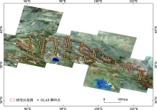
Fig. 1
The location of the study area"

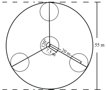
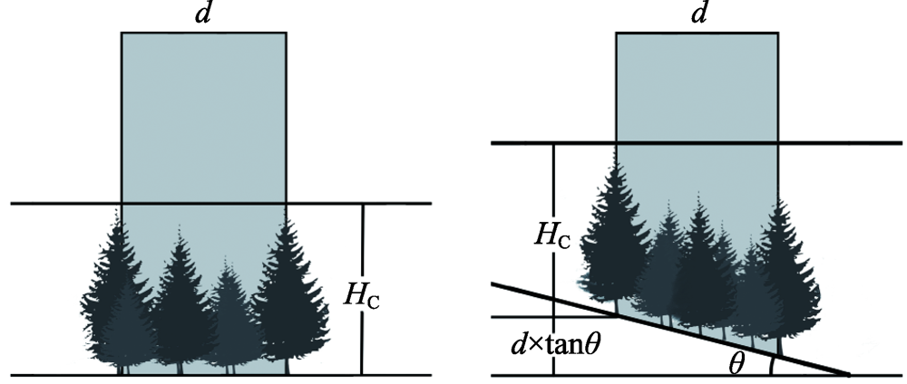
Fig. 2
Conceptual layout of sample plot for measuring canopy heights in the GLAS footprints"


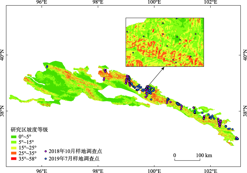
Fig. 3
Distribution of field inventory plots"
Tab. 1
Detailed information of training samples"
| 土地覆被类别 | 样本数量/个 | 栅格数量/个 |
|---|---|---|
| 农田 | 100 | 12937 |
| 灌木 | 102 | 9180 |
| 草地 | 132 | 11223 |
| 森林 | 115 | 8511 |
| 针叶林 | 157 | 20567 |
| 阔叶林 | 109 | 16459 |
| 针阔混交林 | 48 | 5769 |
| 建设用地 | 76 | 8360 |
| 裸地 | 103 | 8652 |
| 水域 | 157 | 15563 |
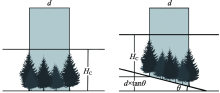
Fig. 4
Effects of different topographical conditions on GLAS-derived canopy height"
Tab. 2
Species-specific allometric equations and carbon content conversion factor in Qilian Mountains"
| 树种 | 异速生长方程 | 参考文献 | 碳含量转换系数 |
|---|---|---|---|
| 青海云杉 Picea crassifolia | | 王金叶等[ | 0.5200[ |
| 祁连圆柏 Juniperus przewalskii | | 王金叶等[ | 0.4650[ |
| 侧柏 Platycladus orientalis | | 关晋宏等[ | 0.5034[ |
| 油松 Pinus tabulaeformis | | 程堂仁等[ | 0.5108[ |
| 蒙古栎 Quercus mongolica | | 关晋宏等[ | 0.5004[ |
| 山杨 Populus davidiana | | 程堂仁等[ | 0.4956[ |
| 白桦 Betula platyphylla | | 程堂仁等[ | 0.5025[ |
Fig. 5
Comparison of GLAS derived canopy height before and after topographic correction in different slope gradient classes"
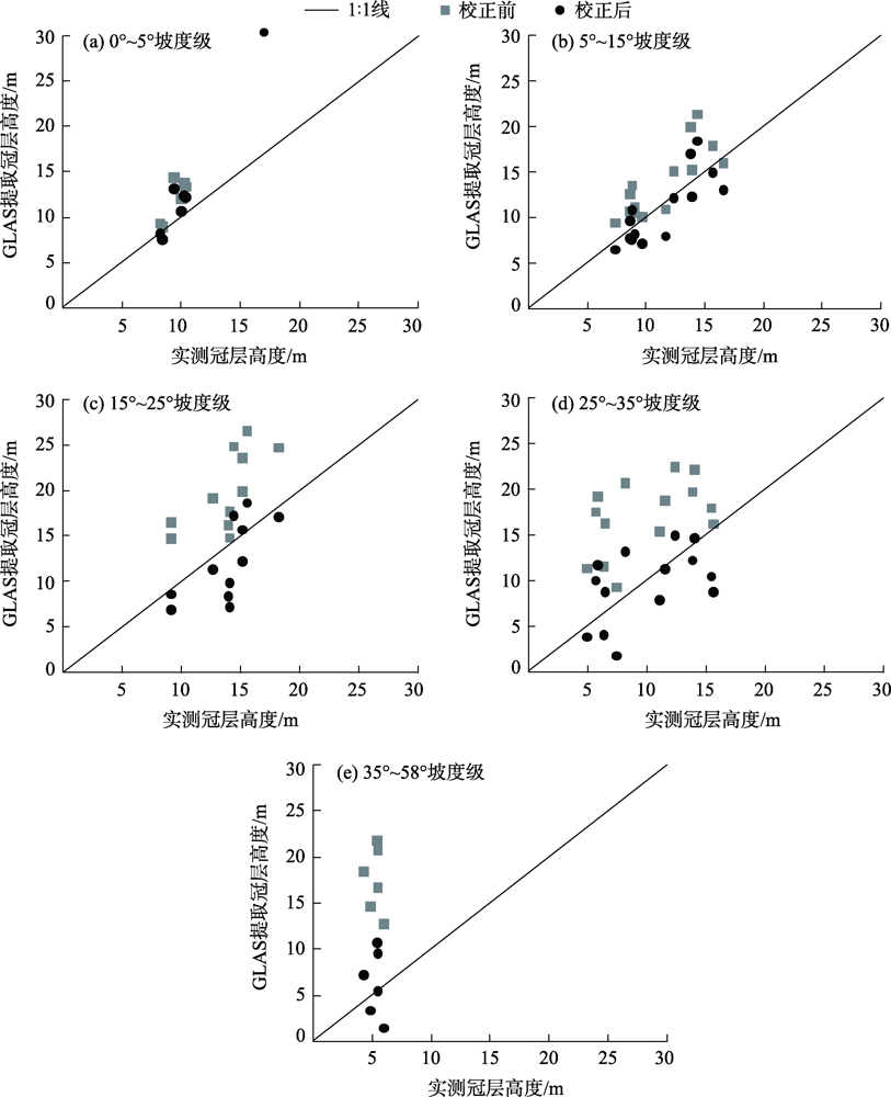
Tab. 3
Accuracy comparison of GLAS derived canopy heights before and after topographic correction in different slope gradient classes"
| 坡度等级 | R2 | RMSE/m | ||
|---|---|---|---|---|
| 校正前 | 校正后 | 校正前 | 校正后 | |
| 0°~5° | 0.62 | 0.66 | 2.83 | 1.84 |
| 5°~15° | 0.64 | 0.65 | 3.32 | 2.23 |
| 15°~25° | 0.66 | 0.67 | 6.74 | 3.51 |
| 25°~35° | 0.63 | 0.65 | 8.00 | 3.91 |
| 35°~58° | 0.65 | 0.67 | 12.59 | 3.48 |
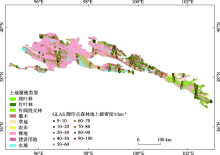
Fig. 6
Estimation of forest aboveground carbon density of GLAS footprints in forest area"

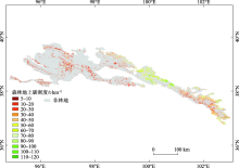
Fig. 7
Forest aboveground carbon density map of Qilian Mountains National Park in 2018"

| [1] |
Pan Y, Birdsey R A, Fang J, et al. A large and persistent carbon sink in the world’s forests[J]. Science, 2011, 333(6045):988-993.
doi: 10.1126/science.1201609 |
| [2] |
Houghton R A, House J I, Pongratz J, et al. Carbon emissions from land use and land-cover change[J]. Biogeosciences, 2012, 9(12):5125-5142.
doi: 10.5194/bg-9-5125-2012 |
| [3] |
Shang X, Chazette P. Interest of a full-waveform flown UV Lidar to derive forest vertical structures and aboveground carbon[J]. Forests, 2014, 5(6):1454-1480.
doi: 10.3390/f5061454 |
| [4] |
Narine L L, Popescu S, Neuenschwander A, et al. Estimating aboveground biomass and forest canopy cover with simulated ICESat-2 data[J]. Remote Sensing of Environment, 2019, 224:1-11.
doi: 10.1016/j.rse.2019.01.037 |
| [5] |
Neigh C S R, Nelson R F, Ranson K J, et al. Taking stock of circumboreal forest carbon with ground measurements, airborne and spaceborne LiDAR[J]. Remote Sensing of Environment, 2013, 137:274-287.
doi: 10.1016/j.rse.2013.06.019 |
| [6] |
Wulder M A, White J C, Nelson R F, et al. Lidar sampling for large-area forest characterization: A review[J]. Remote Sensing of Environment, 2012, 121:196-209.
doi: 10.1016/j.rse.2012.02.001 |
| [7] |
Nelson R, Boudreau J, Gregoire T G, et al. Estimating Quebec provincial forest resources using ICESat/GLAS[J]. Canadian Journal of Forest Research, 2009, 39(4):862-881.
doi: 10.1139/X09-002 |
| [8] |
Baccini A, Goetz S J, Walker W S, et al. Estimated carbon dioxide emissions from tropical deforestation improved by carbon-density maps[J]. Nature Climate Change, 2012, 2(3):182-185.
doi: 10.1038/nclimate1354 |
| [9] |
Tyukavina A, Stehman S V, Potapov P V, et al. National-scale estimation of gross forest aboveground carbon loss: A case study of the Democratic Republic of the Congo[J]. Environmental Research Letters, 2013, 8(4):044039, doi: 10.1088/1748-9326/8/4/044039.
doi: 10.1088/1748-9326/8/4/044039 |
| [10] | 池泓, 黄进良, 邱娟, 等. GLAS星载激光雷达和Landsat/ETM+数据的森林生物量估算[J]. 测绘科学, 2018, 43(4):9-16, 23. |
| [ Chi Hong, Huang Jinliang, Qiu Juan, et al. Estimation of forest aboveground biomass using ICESat/GLAS data and Landsat/ETM+ imagery[J]. Science of Surveying and Mapping, 2018, 43(4):9-16, 23. ] | |
| [11] |
Hilbert C, Schmullius C. Influence of surface topography on ICESat/GLAS forest height estimation and waveform shape[J]. Remote Sensing, 2012, 4(8):2210-2235.
doi: 10.3390/rs4082210 |
| [12] |
Saatchi S S, Harris N L, Brown S, et al. Benchmark map of forest carbon stocks in tropical regions across three continents[J]. Proceedings of the National Academy of Sciences of the United States of America, 2011, 108(24):9899-9904.
doi: 10.1073/pnas.1019576108 pmid: 21628575 |
| [13] |
Huang H, Liu C, Wang X, et al. Integration of multi-resource remotely sensed data and allometric models for forest aboveground biomass estimation in China[J]. Remote Sensing of Environment, 2019, 221:225-234.
doi: 10.1016/j.rse.2018.11.017 |
| [14] |
Wang Y, Li G, Ding J, et al. A combined GLAS and MODIS estimation of the global distribution of mean forest canopy height[J]. Remote Sensing of Environment, 2016, 174:24-43.
doi: 10.1016/j.rse.2015.12.005 |
| [15] | 程鹏, 孔祥伟, 罗汉, 等. 近60 a以来祁连山中部气候变化及其径流响应研究[J]. 干旱区地理, 2020, 43(5):1192-1201. |
| [ Cheng Peng, Kong Xiangwei, Luo Han, et al. Climate change and its runoff response in the middle section of the Qilian Mountains in the past 60 years[J]. Arid Land Geography, 2020, 43(5):1192-1201. ] | |
| [16] | 马剑, 刘贤德, 李广, 等. 祁连山北麓中段青海云杉林土壤水热时空变化特征[J]. 干旱区地理, 2020, 43(4):1033-1040. |
| [ Ma Jian, Liu Xiande, Li Guang, et al. Spatial and temporal variations of soil moisture and temperature of Picea crassifolia forest in north piedmont of central Qilian Mountains[J]. Arid Land Geography, 2020, 43(4):1033-1040. ] | |
| [17] | Fang S, He Z, Du J, et al. Carbon mass change and its drivers in a boreal coniferous forest in the Qilian Mountains, China from 1964 to 2013[J]. Forests, 2018, 9(2):f9020057, doi: 10.3390/f9020057. |
| [18] | Yue J W, Guan J H, Deng L, et al. Allocation pattern and accumulation potential of carbon stock in natural spruce forests in northwest China[J]. Peerj, 2018(6):e4859, doi: 10.7717/peerj.4859. |
| [19] | Zwally H J, Schutz R, Hancock D, et al. GLAS/ICESat L2 global land surface altimetry data (HDF5), version 34[DB/OL]. [2014]. NASA National Snow and Ice Data Center Distributed Active Archive Center. |
| [20] |
Chi H, Sun G, Huang J, et al. National forest aboveground biomass mapping from ICESat/GLAS data and MODIS imagery in China[J]. Remote Sensing, 2015, 7(5):5534-5564.
doi: 10.3390/rs70505534 |
| [21] |
Wei L, Feng Q, Deo R C. Changes in climatic elements in the Pan-Hexi region during 1960—2014 and responses to global climatic changes[J]. Theoretical and Applied Climatology, 2018, 133(1-2):405-420.
doi: 10.1007/s00704-017-2194-6 |
| [22] | 王晓学, 沈会涛, 林田苗, 等. 利用多信息源提高半干旱地区TM影像的森林类型制图精度: 以北京西部山区为例[J]. 自然资源学报, 2017, 32(7):1217-1228. |
| [ Wang Xiaoxue, Shen Huitao, Lin Tianmiao, et al. Improving the forest type mapping accuracy in semiarid mountainous areas based on TM images: Take the west mountain of Beijing as an example[J]. Journal of Natural Resources, 2017, 32(7):1217-1228. ] | |
| [23] |
Park T, Kennedy R E, Choi S, et al. Application of physically-based slope correction for maximum forest canopy height estimation using waveform Lidar across different footprint sizes and locations: Tests on LVIS and GLAS[J]. Remote Sensing, 2014, 6(7):6566-6586.
doi: 10.3390/rs6076566 |
| [24] |
Fick S E, Hijmans R J. WorldClim 2: New 1-km spatial resolution climate surfaces for global land areas[J]. International Journal of Climatology, 2017, 37(12):4302-4315.
doi: 10.1002/joc.2017.37.issue-12 |
| [25] |
Lee S, Ni-Meister W, Yang W, et al. Physically based vertical vegetation structure retrieval from ICESat data: Validation using LVIS in White Mountain National Forest, New Hampshire, USA[J]. Remote Sensing of Environment, 2011, 115(11):2776-2785.
doi: 10.1016/j.rse.2010.08.026 |
| [26] | 王金叶, 车克钧, 蒋志荣. 祁连山青海云杉林碳平衡研究[J]. 西北林学院学报, 2000(1):9-14. |
| [ Wang Jinye, Che Kejun, Jiang Zhirong. A study on carbon balance of Picea crassifolia in Qilian Mountains[J]. Journal of Northwest Forestry College, 2000(1):9-14. ] | |
| [27] | 王金叶, 车克钧, 傅辉恩, 等. 祁连山水源涵养林生物量的研究[J]. 福建林学院学报, 1998(4):34-38. |
| [ Wang Jinye, Che Kejun, Fu Hui’en, et al. Study on biomass of water conservation forest on north slope of Qilian Mountains[J]. Journal of FuJian College of Forestry, 1998(4):34-38. ] | |
| [28] | 罗艳, 唐才富, 辛文荣, 等. 青海省云杉属(Picea)和圆柏属(Sabina)乔木含碳率分析[J]. 生态环境学报, 2014, 23(11):1764-1768. |
| [ Luo Yan, Tang Caifu, Xin Wenrong, et al. Carbon content rate of Picea and Sabina trees in Qinghai Province[J]. Ecology and Environmental Sciences, 2014, 23(11):1764-1768. ] | |
| [29] |
关晋宏, 杜盛, 程积民, 等. 甘肃省森林碳储量现状与固碳速率[J]. 植物生态学报, 2016, 40(4):304-317.
doi: 10.17521/cjpe.2016.0017 |
|
[ Guan Jinhong, Du Sheng, Cheng Jimin, et al. Current stocks and rate of sequestration of forest carbon in Gansu Province, China[J]. Chinese Journal of Plant Ecology, 2016, 40(4):304-317. ]
doi: 10.17521/cjpe.2016.0017 |
|
| [30] |
Zhao M, Yue T, Zhao N, et al. Combining LPJ-GUESS and HASM to simulate the spatial distribution of forest vegetation carbon stock in China[J]. Journal of Geographical Sciences, 2014, 24(2):249-268.
doi: 10.1007/s11442-014-1086-2 |
| [31] | 程堂仁, 马钦彦, 冯仲科, 等. 甘肃小陇山森林生物量研究[J]. 北京林业大学学报, 2007(1):31-36. |
| [ Chen Tangren, Ma Qinyan, Feng Zhongke, et al. Research on forest biomass in Xiaolong Mountains, Gansu Province[J]. Journal of Beijing Forestry University, 2007(1):31-36. ] | |
| [32] | 程堂仁, 冯菁, 马钦彦, 等. 甘肃小陇山森林植被碳库及其分配特征[J]. 生态学报, 2008, 28(1):33-44. |
| [ Cheng Tangren, Feng Jing, Ma Qinyan, et al. Carbon pool and allocation of forest vegetations in Xiaolong Mountains, Gansu Province[J]. Acta Ecologica Sinica, 2008, 28(1):33-44. ] | |
| [33] |
Sileshi G W. A critical review of forest biomass estimation models, common mistakes and corrective measures[J]. Forest Ecology and Management, 2014, 329:237-254.
doi: 10.1016/j.foreco.2014.06.026 |
| [34] | 程堂仁. 甘肃小陇山森林生物量及碳储量研究[D]. 北京: 北京林业大学, 2007. |
| [ Cheng Tangren. Research on the forest biomass and carbon storage in Xiaolong Mountains, Gansu Province[D]. Beijing: Beijing Forestry University, 2007. ] | |
| [35] |
Baccini A, Laporte N, Goetz S J, et al. A first map of tropical Africa’s above-ground biomass derived from satellite imagery[J]. Environmental Research Letters, 2008, 3(4):045011, doi: 10.1088/1748-9326/3/4/045011.
doi: 10.1088/1748-9326/3/4/045011 |
| [36] |
Cao L, Pan J, Li R, et al. Integrating airborne LiDAR and optical data to estimate forest aboveground biomass in arid and semi-arid regions of China[J]. Remote Sensing, 2018, 10(4):532, doi: 10.3390/rs10040532.
doi: 10.3390/rs10040532 |
| [37] |
Ei Hajj M, Baghdadi N, Fayad I, et al. Interest of integrating spaceborne LiDAR data to improve the estimation of biomass in high biomass forested areas[J]. Remote Sensing, 2017, 9(3):213, doi: 10.3390/rs9030213.
doi: 10.3390/rs9030213 |
| [38] |
Phillips S J, Anderson R P, Schapire R E. Maximum entropy modeling of species geographic distributions[J]. Ecological Modelling, 2006, 190(3-4):231-259.
doi: 10.1016/j.ecolmodel.2005.03.026 |
| [39] |
Peng J, Liu Z, Liu Y, et al. Trend analysis of vegetation dynamics in Qinghai-Tibet Plateau using Hurst exponent[J]. Ecological Indicators, 2012, 14(1):28-39.
doi: 10.1016/j.ecolind.2011.08.011 |
| [40] |
Wagner B, Liang E, Li X, et al. Carbon pools of semi-arid Picea crassifolia forests in the Qilian Mountains (north-eastern Tibetan Plateau)[J]. Forest Ecology and Management, 2015, 343:136-143.
doi: 10.1016/j.foreco.2015.02.001 |
| [41] | 巫明焱, 董光, 王艺积, 等. 川西米亚罗自然保护区森林地上碳储量遥感估算[J]. 生态学报, 2020, 40(2):621-628. |
| [ Wu Mingyan, Dong Guang, Wang Yiji, et al. Estimation of forest aboveground carbon storage in Sichuan Miyaluo Nature Reserve based on remote sensing[J]. Acta Ecologica Sinica, 2020, 40(2):621-628. ] | |
| [42] | 穆喜云, 刘清旺, 庞勇, 等. 基于机载激光雷达的森林地上碳储量估测[J]. 东北林业大学学报, 2016, 44(11):52-56. |
| [ Mu Xiyun, Liu Qingwang, Pang Yong, et al. Forest aboveground carbon storage using RF algorithmic model and airborne LiDAR data[J]. Journal of Northeast Forestry University, 2016, 44(11):52-56. ] | |
| [43] |
Wu J, Wang X, Zhang H, et al. Development of a forest canopy height estimation model using GLAS full waveform data over sloping terrain[J]. International Journal of Remote Sensing, 2018, 39(23):9073-9091.
doi: 10.1080/01431161.2018.1506181 |
| [44] | 胡凯龙, 刘清旺, 庞勇, 等. 基于机载激光雷达校正的ICESat/GLAS数据森林冠层高度估测[J]. 农业工程学报, 2017, 33(16):88-95. |
| [ Hu Kailong, Liu Qingwang, Pang Yong, et al. Forest canopy height estimation based on ICESat/GLAS data by airborne Lidar correction[J]. Transactions of the Chinese Society of Agricultural Engineering, 2017, 33(16):88-95. ] | |
| [45] |
Liu K, Wang J, Zeng W, et al. Comparison and evaluation of three methods for estimating forest above ground biomass using TM and GLAS data[J]. Remote Sensing, 2017, 9(4):341, doi: 10.3390/rs9040341.
doi: 10.3390/rs9040341 |
| [1] | FENG Yiming, LYU Chunyan, WANG Ling, ZHAO Weijun, MA Xue’e, DU Junlin, HE Junling. Carbon and nitrogen storage and allocation patterns of Picea crassifolia forest with different stand density [J]. Arid Land Geography, 2023, 46(7): 1133-1144. |
| [2] | LU Xiongying, LIU Xiande, MA Rui, ZHAO Weijun, JING Wenmao, HE Xiaoling, ZHAO Changxing. Response of Picea crassifolia forest regeneration characteristics to topographic factors in Pailugou watershed of Qilian Mountains [J]. Arid Land Geography, 2023, 46(4): 604-613. |
| [3] | SHANG Haiyang,SONG Nini. Poverty risk, livelihood resilience and prevention strategy practice: Investigation and analysis of 8 counties in Qilian Mountains National Nature Reserve [J]. Arid Land Geography, 2021, 44(6): 1784-1795. |
| [4] | WEN Yuhua,LYU Yuemin,LI Zongxing. Changes of extreme precipitation in Qilian Mountains in recent 60 years [J]. Arid Land Geography, 2021, 44(5): 1199-1212. |
| [5] | MA Jian,LIU Xiande,HE Xiaoling,WANG Shunli,HE Yongyan,WU Xiurong,ZHAO Jingzhong,MA Xue'e. Structural characteristics and diversity of typical shrub communities in Qilian Mountains [J]. Arid Land Geography, 2021, 44(5): 1427-1437. |
| [6] | SUN Meiping,SHI Jihua,YAO Xiaojun,ZHANG Haiyu,ZHAO Linlin,MA Weiqian. Effects of glacial surface on cloud structure and cloud water content in summer: A case study of the Shulenan Mountain of Qilian Mountains [J]. Arid Land Geography, 2021, 44(1): 141-148. |
| [7] | ZHANG Kun, XIAO Yan, HE Zhen-fang, GAO Min. Topography features of Qilian Mountains nature reserve based on SRTM DEM [J]. Arid Land Geography, 2020, 43(6): 1559-1566. |
| [8] | LIU Jia-ru, ZHAO Jun, SHEN Si-min, ZHAO Yan-jun. Ecological vulnerability assessment of Qilian Mountains region based on SRP conceptual model [J]. Arid Land Geography, 2020, 43(6): 1573-1582. |
| [9] | CHENG Peng, KONG Xiang-wei, LUO Han, LI Bao-zi, WANG Yan-feng. Climate change and its runoff response in the middle section of the Qilian Mountains in the past 60 years [J]. Arid Land Geography, 2020, 43(5): 1192-1201. |
| [10] | WANG Qing-tao, ZHAO Chuan-yan, WANG Xiao-ping, HU Shan-shan, LIU Mei-yan, SHI Wen-yu, WANG Xiao-yu, SHAN Wen-rong. Simulating the biomass carbon distribution of young-and-middle aged Picea crassifolia forests based on FAREAST model along altitude gradients [J]. Arid Land Geography, 2020, 43(5): 1316-1326. |
| [11] | MA Jian, LIU Xian-de, LI Guang, ZHAO Wei-jun, WANG Shun-li, JING Wen-mao, MA Xue-e. Spatial and temporal variations of soil moisture and temperature of Picea Crassifolia forest in north piedmont of central Qilian Mountains [J]. Arid Land Geography, 2020, 43(4): 1033-1040. |
| [12] |
QIU Li-sha, HE Yi, ZHANG Li-feng, WANG Wen-hui, TANG Yuan-wei.
Spatiotemporal variation characteristics and influence factors of MODIS LST in Qilian Mountains [J]. Arid Land Geography, 2020, 43(3): 726-737. |
| [13] | ZHAO Jian-lin, KANG De-kui, PENG Wei-en, WANG Jian-li, SHI Zhong-xing, CHEN Tian-shun, DONG Zhi-yang, WANG Jie, CHANG Zhao-feng. Relative ecological value of vegetation restoration after migrating people from Qilian Mountains to Jingdian Irrigation Area [J]. Arid Land Geography, 2020, 43(1): 182-189. |
| [14] | MA Jian, LIU Xian-de, LI Guang, ZHAO Wei-jun, WANG Shun-li, JING Wen-mao, WANG Rong-xin, ZHAO Yong-hong. Evaluation on soil fertility quality of Picea crassifolia forest in middle Qilian Mountains [J]. Arid Land Geography, 2019, 42(6): 1368-1377. |
| [15] | MA Xinggang, JIA Wenxiong, DING Dan, ZHU Guofeng, GONG Ninggang, XU Xiuting, YUAN Ruifeng. Variation characteristics of δ17O in precipitation and moisture transports in eastern Qilian Mountains [J]. Arid Land Geography, 2019, 42(3): 517-525. |
|
||